| ||||||||||||||
| Yavapai County, Arizona | ||
 Yavapai County Courthouse in Prescott
| ||
| ||
 Location in the state of Arizona | ||
 Arizona's location in the U.S. | ||
| Founded | November 9, 1864 | |
|---|---|---|
| Named for | Yavapai people | |
| Seat | Prescott | |
| Largest city | Prescott Valley (fully within Yavapai County) | |
| Area - Total - Land - Water |
8,128 sq mi (21,051 km²) 8,123 sq mi (21,038 km²) 4.4 sq mi (11 km²), 0.05 | |
| Population - (2020) - Density |
236,209 | |
| Congressional districts | 1st, 4th | |
| Time zone | Mountain: UTC-7 | |
| Website | yavapai.us | |
Yavapai County is near the center of the U.S. state of Arizona. As of the 2020 census, its population was 236,209, making it the fourth-most populous county in Arizona.[1] The county seat is Prescott.[2]
Yavapai County comprises the Prescott, AZ Metropolitan Statistical Area as well as the northern portions of Peoria and Wickenburg, the balance of which are in the Phoenix Metropolitan Area.
History[]


Old gold specimen from an unknown Yavapai County mine. Size: Template loop detected: Template:Convert/x.
Yavapai County was one of the four original Arizona counties created by the 1st Arizona Territorial Legislature. The county territory was defined as being east of longitude 113° 20' and north of the Gila River.[3] Soon thereafter, the counties of Apache, Coconino, Maricopa, and Navajo were carved from the original Yavapai County. Yavapai County's present boundaries were established in 1891.
The county is named after the Yavapai people, who were the principal inhabitants at the time the United States annexed the area.
County level law enforcement services have been provided by Yavapai County Sheriff's Office since 1864.
Geography[]
According to the U.S. Census Bureau, the county has a total area of 8,128 square miles (21,050 km2), of which 8,123 square miles (21,040 km2) is land and 4.4 square miles (11 km2) (0.05%) is water.[4] It has about 93% of the area of the U.S. state of New Jersey. It is larger than three U.S. states (Rhode Island, Delaware and Connecticut) and the District of Columbia combined.
The county's topography makes a dramatic transition from the lower Sonoran Desert to the south to the heights of the Coconino Plateau to the north, and the Mogollon Rim to the east. The highest point above sea level (MSL) in Yavapai County is Mount Union at an elevation of 7,979 ft (2,432 m) and the lowest is Agua Fria River drainage, now under Lake Pleasant.
Adjacent counties[]
- Mohave County – west
- La Paz County – southwest
- Maricopa County – south
- Gila County – east
- Coconino County – north/northeast
Major highways[]
 Interstate 17
- Interstate 40
- U.S. Route 93
- State Route 69
- State Route 71
- State Route 89
- State Route 169
- State Route 179
- State Route 260
- State Route 279
National protected areas[]


West Clear Creek Wilderness

West Fork of Oak Creek, in the Red Rock-Secret Mountain Wilderness
- Agua Fria National Monument
- Coconino National Forest (part)
- Kaibab National Forest (part)
- Montezuma Castle National Monument
- Prescott National Forest (part)
- Tonto National Forest (part)
- Tuzigoot National Monument
There are nineteen official wilderness areas in Yavapai County that are part of the National Wilderness Preservation System. Fourteen of these are integral parts of National Forests listed above, whereas five are managed by the Bureau of Land Management. Some of these extend into neighboring counties (as indicated below):
- Apache Creek Wilderness (Prescott NF)
- Arrastra Mountain Wilderness (BLM) mostly in Mohave County; also partly in La Paz County
- Castle Creek Wilderness (Prescott NF)
- Cedar Bench Wilderness (Prescott NF)
- Fossil Springs Wilderness (Coconino NF) mostly in Coconino County
- Granite Mountain Wilderness (Arizona) (Prescott NF)
- Hassayampa River Canyon Wilderness (BLM)
- Hells Canyon Wilderness (Arizona) (BLM) partly in Maricopa County
- Juniper Mesa Wilderness (Prescott NF)
- Mazatzal Wilderness (Tonto NF / Coconino NF) partly in Gila County; Maricopa County
- Munds Mountain Wilderness (Coconino NF) mostly in Coconino County
- Pine Mountain Wilderness (Tonto NF/Prescott NF)
- Red Rock-Secret Mountain Wilderness (Coconino NF) partly in Coconino County
- Sycamore Canyon Wilderness (Prescott NF/Coconino NF / Kaibab NF) mostly in Coconino County
- Tres Alamos Wilderness (BLM)
- Upper Burro Creek Wilderness (BLM) partly in Mohave County
- West Clear Creek Wilderness (Coconino NF) partly in Coconino County
- Wet Beaver Wilderness (Coconino NF) partly in Coconino County
- Woodchute Wilderness (Prescott NF)
Land ownership and management[]
- Private ownership: about 25% of Yavapai County's land (by area) is privately owned.
- Public land: about 75% of the county's area is publicly owned, including
- Federal ownership: about 50% of the county's area is owned by the federal government of the United States, including
- National Forest lands, managed by the US Forest Service: 38% of the county's area
- Federal lands managed by the U.S. Bureau of Land Management: 11.6% of the county's area
- Small areas of federal land are managed by the U.S. Bureau of Indian Affairs and the National Park Service: less than 0.5% of the county's area.
- Yavapai-Prescott Tribe 1,413 acres (571.8 ha)
- Yavapai-Apache Nation 685 acres (277.2 ha)
- About 25% of Yavapai County is owned by the State of Arizona as state trust lands, managed by the Arizona State Land Department.[5]
Flora and fauna[]
There are numerous flora and fauna species within Yavapai County. For example, a number of plants within the genus Ephedra and Coreopsis are found in the county.
Attractions[]
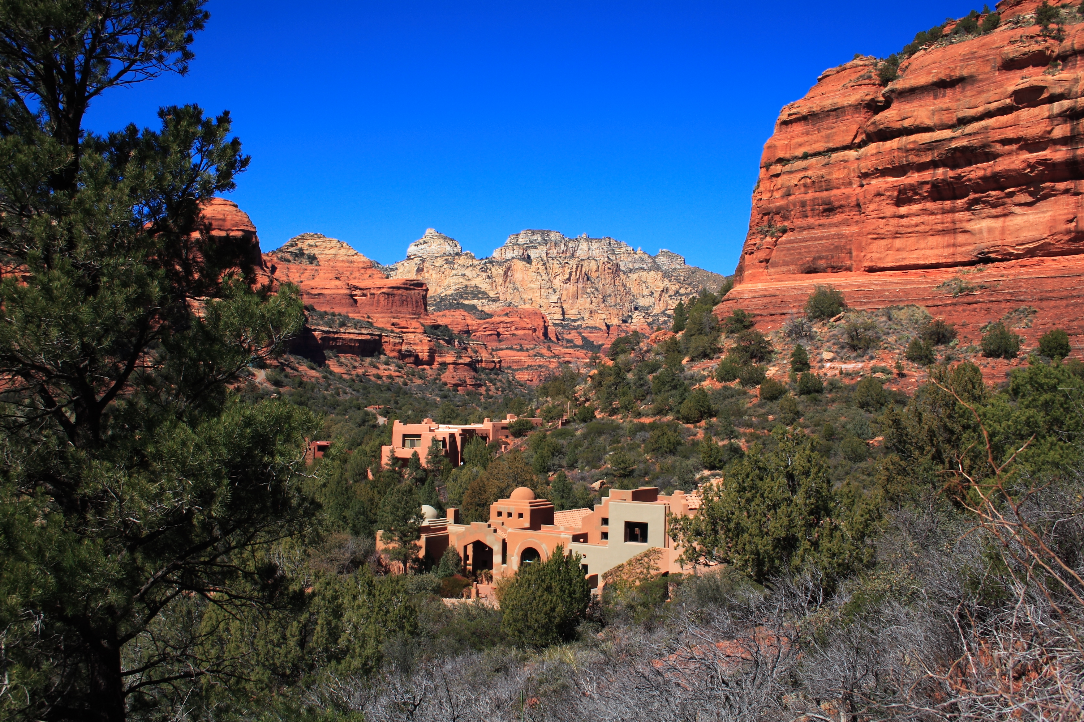

Enchantment Resort near Sedona
Yavapai County is home to Arcosanti, a prototype arcology, developed by Paolo Soleri, and under construction since 1970. Arcosanti is just north of Cordes Junction, Arizona.
Out of Africa Wildlife Park is a private zoo. The park moved to the Camp Verde area from the East Valley in 2005.
Approximately 10 miles (16 km) northwest of the town of Bagdad lies the Upper Burro Creek Wilderness Area, a 27,440-acre (11,105 ha) protected area home to at least 150 species of birds and featuring one of the Arizona desert's few undammed perennial streams.
Demographics[]
| Historical populations | |||
|---|---|---|---|
| Census | Pop. | %± | |
| 1870 | 2,142 | ||
| 1880 | 5,013 | 134.0% | |
| 1890 | 8,685 | 73.2% | |
| 1900 | 13,799 | 58.9% | |
| 1910 | 15,996 | 15.9% | |
| 1920 | 24,016 | 50.1% | |
| 1930 | 28,470 | 18.5% | |
| 1940 | 26,511 | −6.9% | |
| 1950 | 24,991 | −5.7% | |
| 1960 | 28,912 | 15.7% | |
| 1970 | 36,733 | 27.1% | |
| 1980 | 68,145 | 85.5% | |
| 1990 | 107,714 | 58.1% | |
| 2000 | 167,517 | 55.5% | |
| 2010 | 211,033 | 26.0% | |
| U.S. Decennial Census[6] 1790–1960[7] 1900–1990[8] 1990–2000[9] 2010–2020[1] | |||
2000 census[]
As of the 2000 census, there were 167,517 people, 70,171 households, and 46,733 families living in the county. The population density was 21 inhabitants per square mile (8.1 /km2). There were 81,730 housing units at an average density of 10 per square mile (3.9 /km2). The racial makeup of the county was 91.9% White, 0.4% Black or African American, 1.6% Native American, 0.5% Asian, 0.1% Pacific Islander, 3.6% from other races, and 2.0% from two or more races. 9.8% of the population were Hispanic or Latino of any race.
There were 70,171 households, out of which 23.8% had children under the age of 18 living with them, 55.0% were married couples living together, 8.1% had a female householder with no husband present, and 33.4% were non-families. 26.7% of all households were made up of individuals, and 12.4% had someone living alone who was 65 years of age or older. The average household size was 2.33 and the average family size was 2.79.
In the county, the population was spread out, with 21.1% under the age of 18, 7.1% from 18 to 24, 22.4% from 25 to 44, 27.4% from 45 to 64, and 22.0% who were 65 years of age or older. The median age was 44 years. For every 100 females there were 96.2 males. For every 100 females age 18 and over, there were 93.5 males.
The median income for a household in the county was $34,901, and the median income for a family was $40,910. Males had a median income of $30,738 versus $22,114 for females. The per capita income for the county was $19,727. About 7.9% of families and 11.9% of the population were below the poverty line, including 15.9% of those under age 18 and 6.7% of those age 65 or over.
By 2017 Census Bureau Estimates placed the population of Yavapai County at 228,168. This represented a 24.2% growth in the population since 2000.[10]
Yavapai County is defined as the Prescott Metropolitan Statistical Area by the United States Census Bureau.[11]
2010 census[]
As of the 2010 census, there were 211,033 people, 90,903 households, and 57,597 families living in the county.[12] The population density was 26.0 inhabitants per square mile (10.0 /km2). There were 110,432 housing units at an average density of 13.6 per square mile (5.3 /km2).[13] The racial makeup of the county was 89.3% white, 1.7% American Indian, 0.8% Asian, 0.6% black or African American, 0.1% Pacific islander, 4.9% from other races, and 2.5% from two or more races. Those of Hispanic or Latino origin made up 13.6% of the population.[12] The largest ancestry groups were:[14]
Of the 90,903 households, 22.8% had children under the age of 18 living with them, 50.3% were married couples living together, 9.0% had a female householder with no husband present, 36.6% were non-families, and 29.1% of all households were made up of individuals. The average household size was 2.28 and the average family size was 2.78. The median age was 49.2 years.[12]
The median income for a household in the county was $43,290 and the median income for a family was $53,499. Males had a median income of $40,854 versus $31,705 for females. The per capita income for the county was $25,527. About 8.8% of families and 13.7% of the population were below the poverty line, including 20.1% of those under age 18 and 6.1% of those age 65 or over.[15]
Politics[]
Yavapai has historically been the most Republican county in Arizona, though it has become rivalled by Graham and exceeded by Mohave since the turn of the century. No Democratic presidential nominee has won Yavapai County since Harry S. Truman in 1948, and even when the county did go Democratic in the Truman and Roosevelt eras, it typically did so by a smaller margin than any other county in the state.
| Year | Republican | Democratic | Third party | |||
|---|---|---|---|---|---|---|
| No. | % | No. | % | No. | % | |
| 2020 | 91,527 | 63.72% | 49,602 | 34.53% | 2,511 | 1.75% |
| 2016 | 71,330 | 62.32% | 35,590 | 31.10% | 7,530 | 6.58% |
| 2012 | 64,468 | 64.04% | 33,918 | 33.69% | 2,281 | 2.27% |
| 2008 | 61,192 | 61.08% | 36,889 | 36.82% | 2,104 | 2.10% |
| 2004 | 53,468 | 61.05% | 33,127 | 37.82% | 988 | 1.13% |
| 2000 | 40,144 | 58.84% | 24,063 | 35.27% | 4,021 | 5.89% |
| 1996 | 29,921 | 50.29% | 21,801 | 36.64% | 7,773 | 13.06% |
| 1992 | 23,419 | 39.42% | 18,268 | 30.75% | 17,728 | 29.84% |
| 1988 | 27,842 | 64.44% | 14,514 | 33.59% | 850 | 1.97% |
| 1984 | 24,802 | 70.89% | 9,609 | 27.46% | 577 | 1.65% |
| 1980 | 19,823 | 68.37% | 6,664 | 22.98% | 2,507 | 8.65% |
| 1976 | 12,998 | 60.18% | 7,685 | 35.58% | 917 | 4.25% |
| 1972 | 12,277 | 65.77% | 3,977 | 21.30% | 2,413 | 12.93% |
| 1968 | 8,296 | 58.44% | 3,989 | 28.10% | 1,911 | 13.46% |
| 1964 | 7,749 | 57.16% | 5,747 | 42.39% | 60 | 0.44% |
| 1960 | 6,813 | 61.12% | 4,325 | 38.80% | 9 | 0.08% |
| 1956 | 6,339 | 65.66% | 3,315 | 34.34% | 0 | 0.00% |
| 1952 | 6,567 | 64.41% | 3,628 | 35.59% | 0 | 0.00% |
| 1948 | 4,287 | 48.05% | 4,439 | 49.75% | 196 | 2.20% |
| 1944 | 3,529 | 44.33% | 4,395 | 55.21% | 36 | 0.45% |
| 1940 | 3,987 | 38.78% | 6,217 | 60.46% | 78 | 0.76% |
| 1936 | 2,794 | 28.15% | 6,628 | 66.77% | 504 | 5.08% |
| 1932 | 2,626 | 28.73% | 6,326 | 69.20% | 189 | 2.07% |
| 1928 | 4,507 | 57.83% | 3,285 | 42.15% | 2 | 0.03% |
| 1924 | 2,827 | 41.80% | 1,800 | 26.62% | 2,136 | 31.58% |
| 1920 | 3,625 | 61.69% | 2,251 | 38.31% | 0 | 0.00% |
| 1916 | 1,716 | 34.44% | 2,893 | 58.06% | 374 | 7.51% |
| 1912 | 445 | 18.84% | 1,001 | 42.38% | 916 | 38.78% |
Communities[]


Former Superintendent's Residence, UVX Smelter, Cottonwood. Listed on the National Register of Historic Places.
Cities[]
- Cottonwood
- Peoria (partly in Maricopa County)
- Prescott (county seat)
- Sedona (partly in Coconino County)
Towns[]
- Camp Verde
- Chino Valley
- Clarkdale
- Dewey-Humboldt
- Jerome
- Prescott Valley
- Wickenburg (partly in Maricopa County)
Census-designated places[]
- Ash Fork
- Bagdad
- Black Canyon City
- Congress
- Cordes Lakes
- Cornville
- Lake Montezuma
- Mayer
- Paulden
- Peeples Valley
- Seligman
- Spring Valley
- Verde Village
- Village of Oak Creek
- Wilhoit
- Williamson
- Yarnell
Indian communities[]
- Yavapai-Apache Nation
- Yavapai-Prescott Tribe
Unincorporated communities[]
- Arcosanti
- Bumble Bee
- Cherry
- Cleator
- Clemenceau
- Cordes
- Crown King
- Drake
- Iron Springs
- Kirkland
- Ponderosa Park
- Skull Valley
- Tip Top
Ghost towns[]
- Alexandra
- American Ranch
- Apron Crossing
- Big Bug
- Bradshaw City
- Bumble Bee
- Chaparral
- Catoctin
- Cherry
- Cleator
- Clemenceau
- Congress
- Cordes
- Curtis
- Gillett
- Jerome
- Octave
- Piedmont
- Simmons
- Stanton
- Stoddard
- Tip Top
- Weaver
Geographic features[]
- Sunset Point is a cliff adjacent to Interstate 17. It has an elevation of 3,091 ft (942 m).[17] The Sunset Point Rest Area, located at the top of the cliff, provides travelers with a scenic view.[18]
County population ranking[]
The population ranking of the following table is based on the 2010 census of Yavapai County.[19][20]
† county seat
| Rank | City/Town/etc. | Population (2010 Census) | Municipal type | Incorporated |
|---|---|---|---|---|
| 1 | Peoria (most of population in Maricopa County) | 154,065 | City | 1954 |
| 2 | † Prescott | 39,843 | City | 1883 |
| 3 | Prescott Valley | 38,822 | Town | 1978 |
| 4 | Verde Village | 11,605 | CDP | |
| 5 | Cottonwood | 11,265 | City | 1960 |
| 6 | Camp Verde | 10,873 | Town | 1986 |
| 7 | Chino Valley | 10,817 | Town | 1970 |
| 8 | Sedona (partly in Coconino County) | 10,031 | City | 1988 |
| 9 | Wickenburg (Most of population in Maricopa County) | 6,363 | Town | 1909 |
| 10 | Village of Oak Creek (Big Park) | 6,147 | CDP | |
| 11 | Williamson | 5,438 | CDP | |
| 12 | Paulden | 5,231 | CDP | |
| 13 | Lake Montezuma | 4,706 | CDP | |
| 14 | Clarkdale | 4,097 | Town | 1957 |
| 15 | Dewey-Humboldt | 3,894 | Town | 2004 |
| 16 | Cornville | 3,280 | CDP | |
| 17 | Black Canyon City | 2,837 | CDP | |
| 18 | Cordes Lakes | 2,633 | CDP | |
| 19 | Congress | 1,975 | CDP | |
| 20 | Bagdad | 1,876 | CDP | |
| 21 | Mayer | 1,497 | CDP | |
| 22 | Spring Valley | 1,148 | CDP | |
| 23 | Wilhoit | 868 | CDP | |
| 24 | Yarnell | 649 | CDP | |
| 25 | Seligman | 445 | CDP | |
| 26 | Jerome | 444 | Town | 1899 |
| 27 | Peeples Valley | 428 | CDP | |
| 28 | Ash Fork | 396 | CDP |
See also[]
- National Register of Historic Places listings in Yavapai County, Arizona
References[]
- ^ a b "State & County QuickFacts". https://www.census.gov/quickfacts/fact/table/yavapaicountyarizona/POP010220.
- ^ "Find a County". National Association of Counties. http://www.naco.org/Counties/Pages/FindACounty.aspx.
- ^ Wagoner, Jay J. (1970). Arizona Territory 1863–1912: A Political history. Tucson: University of Arizona Press. pp. 58. ISBN 0-8165-0176-9. https://archive.org/details/arizonaterritory00wago/page/58.
- ^ "2010 Census Gazetteer Files". United States Census Bureau. August 23, 2012. http://www2.census.gov/geo/docs/maps-data/data/gazetteer/counties_list_04.txt.
- ^ Yavapai County Profile
- ^ "U.S. Decennial Census". United States Census Bureau. https://www.census.gov/programs-surveys/decennial-census.html.
- ^ "Historical Census Browser". University of Virginia Library. http://mapserver.lib.virginia.edu.
- ^ "Population of Counties by Decennial Census: 1900 to 1990". United States Census Bureau. https://www.census.gov/population/cencounts/az190090.txt.
- ^ "Census 2000 PHC-T-4. Ranking Tables for Counties: 1990 and 2000". United States Census Bureau. https://www.census.gov/population/www/cen2000/briefs/phc-t4/tables/tab02.pdf.
- ^ "Yavapai County QuickFacts from the US Census Bureau". http://quickfacts.census.gov/qfd/states/04/04025.html.
- ^ "OMB Bulletin No. 07-01: Update of Statistical Area Definitions and Guidance on Their Uses". United States Office of Management and Budget. December 18, 2006. https://www.whitehouse.gov/omb/bulletins/fy2007/b07-01.pdf.
- ^ a b c "DP-1 Profile of General Population and Housing Characteristics: 2010 Demographic Profile Data". United States Census Bureau. http://factfinder.census.gov/bkmk/table/1.0/en/DEC/10_DP/DPDP1/0500000US04025.
- ^ "Population, Housing Units, Area, and Density: 2010 – County". United States Census Bureau. http://factfinder.census.gov/bkmk/table/1.0/en/DEC/10_SF1/GCTPH1.CY07/0500000US04025.
- ^ "DP02 Selected Social Characteristics in the United States – 2006–2010 American Community Survey 5-Year Estimates". United States Census Bureau. http://factfinder.census.gov/bkmk/table/1.0/en/ACS/10_5YR/DP02/0500000US04025.
- ^ "DP03 Selected Economic Characteristics – 2006–2010 American Community Survey 5-Year Estimates". United States Census Bureau. http://factfinder.census.gov/bkmk/table/1.0/en/ACS/10_5YR/DP03/0500000US04025.
- ^ "Dave Leip's Atlas of United States Presidential Elections". http://uselectionatlas.org/RESULTS/.
- ^ USGS GNIS: Sunset Point (cliff)
- ^ USGS GNIS: Sunset Point Rest Area
- ^ CNMP, US Census Bureau. "This site has been redesigned and relocated. - U.S. Census Bureau". https://www.census.gov/programs-surveys/decennial-census/decade.2010.html.
- ^ Geography, US Census Bureau. "2010 Census Block Maps". https://www.census.gov/geo/maps-data/maps/block/2010/.
Sources[]
- Fuis, G. S. (1996). The geology and mechanics of formation of the Fort Rock dome, Yavapai County, Arizona [U.S. Geological Survey Professional Paper 1266]. Washington, D.C.: U.S. Geological Survey, U.S. Department of the Interior.
External links[]
- Geographic data related to Yavapai County, Arizona at OpenStreetMap
- Yavapai County Profile by Arizona Department of Commerce
- Prescott eNews – original local news Web site for Prescott (the county seat) and the surrounding communities.
- Yavapai County government website
| ||||||||||||||||||||

.jpg)
.jpg)
| ||||||||||||||||||||
|
| This page uses content from the English language Wikipedia. The original content was at Yavapai County, Arizona. The list of authors can be seen in the page history. As with this Familypedia wiki, the content of Wikipedia is available under the Creative Commons License. |