| Main | Births etc |
|---|
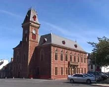
Wigtownshire's former seat of government, the County Buildings in Machars. photo by Shaun Bythell
Scotland's largest second-hand bookshop. photo by Shaun Bythell
| Wigtown | |
| Scottish Gaelic: Baile na h-Ùige | |
| Scots: Wigtoun | |

Wigtown | |
| Population | 987 (2001 Census) |
|---|---|
| OS grid reference | |
| Council area | Dumfries and Galloway |
| Lieutenancy area | Wigtown |
| Country | Scotland |
| Sovereign state | United Kingdom |
| Post town | NEWTON STEWART |
| Postcode district | DG8 |
| Dialling code | 01988 |
| Police | Dumfries and Galloway |
| Fire | Dumfries and Galloway |
| Ambulance | Scottish |
| EU Parliament | Scotland |
| UK Parliament | Dumfries and Galloway |
| Scottish Parliament | Galloway and West Dumfries |
| List of places: UK • Scotland • | |
Wigtown (Scots: Wigtoun,[1] Scottish Gaelic: Baile na h-Ùige) is a town and former royal burgh in Wigtownshire in the District Council Region of Dumfries and Galloway in Scotland. It lies east of Stranraer and south of Newton Stewart.[2] It is well known today as Scotland's National Book Town with a concentration of second-hand book shops. It has a population of about 1,000.
Wigtown is also the name of a ward, a government district in the region of Dumfries and Galloway council. The ward covers a larger area than the town, about six miles long and four miles wide, comprising about 7000 acres bounded on the east by Wigtown bay and on the south by the river Bladnoch.
Wigtown is the gateway to and main centre of the Machars.
Due to the North Atlantic Drift (Gulf Stream) the climate is mild and plants normally associated with the Southern Hemisphere can successfully be grown here.
Scotland's National Book Town[]
The town now also plays host to an annual Wigtown Book Festival. http://www.wigtown-booktown.co.uk/
Today Wigtown is known as Scotland's "book town" and compared to Hay-on-Wye in Wales for the same reason. There is a significant difference from Hay-on-Wye: Wigtown's status as a book town was planned, in order to regenerate a very depressed town (the main employers, the creamery and distillery, having closed in the 1990s), although the distillery (Bladnoch) has now re-opened and is distilling its own malt whisky. There was a national search (in Scotland) for a candidate town.
Wigtown once boasted over 20 book-related businesses including bookshops and publishers, but has seen a decline in recent years to barely 12. Some of the bookshops are to be found in surrounding villages, in industrial units and in people's homes.
The Town[]
One 18th-century historian of the county Samuel Robinson noted that ‘the greatest number of houses were of a homely character, thatched and one storey high’. Each house, he continued, had a midden in front of it. Bishop Pococke in 1760 also noted the existence of thatched houses. By the end of the 19th century it was said that two houses in the town were hardly the same; some had gable ends, others had large fronts pierced by pigeon-hole windows, while still others had outside stairs. Wigtown was described as the quaintest county town in Scotland [3]
Town Council improvements in the early 19th century greatly altered the face of Main Street. In 1809 town magistrates resolved to improve the main street at a moderate expense by lifting the pavement and making a gravel road around each side of the street, the outer edge of which was to be 44 feet from the edge of the houses. A ‘plantation’ was to be left in the centre of the thoroughfare, which was later laid out with shrubs and enclosed by a rail. In 1830, the Wigtown Bowling club obtained a footing in the ‘plantation’ and by the turn of the 20th century, the square was used largely by bowlers and tennis players. Much of the square was planted up in the mid-20th century, but in 2002 it was restored to the elegant Georgian open plan fringed by trees.
The Newton Stewart to Whithorn Branch Line Railway stopped at Wigtown Station (the first train ran on 2 March 1875). The service ceased in 1950. The closure of the railway service led directly to the decline of the town's main industry - the Bladnoch Creamery.
Schools[]
Wigtown’s grammar school is the oldest in Wigtownshire. Until 1712 the school does not appear to have been conducted in a building set aside for that purpose, and it was in that century that the council ordered all inhabitants owning horses to bring a draught of timber from a nearby wood to help in the construction of a schoolhouse. Near the end of the century the council noted that the schoolhouse was overcrowded and needed improvement, but because of the poor state of the town’s finances, the magistrates could do little to help at that time. The schoolmaster was urged to find more room in the town at the expense of the ‘stranger scholaris’.
A Roman Catholic primary school was built opposite the school but closed in 2004.
Church[]
The parish church of Wigtown was dedicated to an obscure 6th-century British saint, [Machutus]. On display within the modern parish church is a Celtic interlaced cross shaft of the Whithorn School dating back to approximately 1000 AD. Precisely how old the church is remains a mystery, and although at one time it belonged to the priory of Whithorn, Wigtown parish church was afterwards set up as a free rectory with the king as patron. A church was erected on the site of the medieval parish church in 1730, and almost within a century that church was ruinous, for a third parish church was built close by in 1850. Portions of the 1730 church survive, although fragments of this may, in fact, be older than that date, for there is a window, on the south side aisle ornamented with trefoiled heads and stone mullions with shields carved on them. Some residents of Wigtown maintain that the ruins date back to the 13th century. A Catholic Church church was built in the town in 1879.
Places of interest[]
Wigtown lies less than a mile from Bladnoch, a village with a distillery producing malt whisky of the same name. The River Bladnoch can be fished for Atlantic salmon and has historically been well known as one of Scotland's finest rivers producing spring fish. It meets the River Cree in Wigtown Bay, meandering through a large area of salt marsh which has been designated as a Local Nature Reserve (LNR). Wigtown Bay is the largest LNR in Britain, and is home to a wealth of wildlife, particularly birds. Some people come to admire them from the comfort of the viewing huts situated near the harbour, others come to shoot them. The first pair of ospreys to return to Galloway in over 100 years arrived in 2004. A live camera link to their nest was created and can be viewed in the County Buildings.
The Wigtown and Bladnoch Golf Club has a nine hole golf course on the outskirts of Wigtown.
To the East of Wigtown is The Martyr's Stake, a monument marking the traditional site where the two Margarets were drowned in the 17th century. Their graves are in the Parish Church cemetery. There is a small cell in the County Buildings in which they were imprisoned prior to their execution. This cell is all that remains of a much older building which was largely destroyed to make way for the County Buildings (built in 1862). A larger monument to the Covenanters stands on Windy Hill in the town.
Name origins[]
W.F.H. Nicolaisen offered two explanations for the place-name Wigtown. One theory was that is meant ‘dwelling place’, from the Old English 'wic-ton'; however, if it is the same as Wigton in Cumbria, which was 'Wiggeton' in 1162 and 'Wigeton' in 1262, it may be ‘Wigca’s farm'. Other sources have suggested a Norse root with 'Wic' or 'Wig' meaning 'bay', giving the origin as a translation of 'The town on the bay'.
Bronze Age[]


Torehousekie Stone Circle dating from 2nd millennium BC, is one of the best preserved sites in Britain. It is approx. 60ft in diameter. photo by Ronnie Leask
The surrounding area (the Machars peninsula) is rich in prehistoric remains, most notably the Torhousekie Standing Stones, a Neolithic stone circle set on a raised platform of smaller stones. It consists of nineteen boulders up to 5 feet high aligned to the winter solstice, surrounding a ring cairn on which there are 3 large stones (flankers), two upright and one recumbent. On a low ridge across the road from the circle there are another three stones.
The Burgh - Medieval period[]
Andrew Symson, a 17th-century minister, suggested the first settlement would have stood on low-lying sands between the present-day Wigtown and Creetown.[4]
A large, broad street was the focal point of settlement in the medieval town, but it was greatly altered at the beginning of the main street which in turn terminated in the latter-day Bank Street. High Vennel and low vennel are both early thoroughfares.
The burgh appeared briefly in the customs report for 1330 and 1331, but the amount collected was small and its hey-day as a port was principally in the 15th century. Even at the best of times, trade in the south-west of Scotland was small in quantity.
The royal burgh was granted to Sir Malcom Fleming by David II in 1341. In 1372 Wigtown passed to the Earls of Douglas, upon the sale of the Earldom to Archibald the Grim, but was restored to its former tenure as a royal burgh as a result of the forfeiture of the Douglases in 1455. Its status was formally recognised be a royal charter in 1457 and from then the burgh was firmly fixed by a feud-charter at the old figure of £20 per annum.
Wigtown was made a royal burgh in 1469 although a settlement here existed long before this. Wigtown attended Parliament regularly from 1469 and the Convention of Royal Burghs from 1575.
In 1500-1 only two ships called at Wigtown and Kirkcudbright, and at other times there was no overseas trade at all.
"Two Gates"[]
Wigtown had two ports [gates] which some writers have asserted were closed at night to form a large cattle enclosure. Andrew Symson referred to the East Port, which stood near NX 4352 5545 (Ordnance Survey Record Cards, NX 45 NW 18), The West Port stood opposite the mouth of the High Vennel and traces of it were still to be seen in the 1930s. The ports of the town were formed by projecting houses stretching across the street from both sides and a gate being placed in the centre. In the late 19th century, one of these projecting houses still stood at the site of the West Port, and was a thing, in his opinion, ‘anything but ornamental to the town’. The West Port can be seen on the map at the Cross, on the junction of North and South Mount Streets. (To view, hold down (Shift) key, and move your cursor on map at http://maps.nls.uk/townplans/view/?sid=74417072&mid=wigtown_2#sid=74417072&mid=wigtown_2&zoom=6&lat=8105.5&lon=11493.5&layers=BT )
In 1742 there is a reference to digging a well outside the west Port. This well would probably have been the one known as the White Pump.
The town council in 1761 decided that the ports were ‘hurtful to the place’ in that they ‘greatly incommode the carrying of corps of the deceased through the same’. Stone from the ports, which were ordered to be pulled down to their foundations, was ordered to be stored in a most secure manner, so that ‘they may answer the uses of the burgh when they have the occasion’.
13th century Burgh[]
The burgh is mentioned in an indenture of 1292, and the fact that the sheriffdom was in existence at the time of the Largs campaign of 1263 suggests that the burgh may also have been recognised as such during the reign of Alexander III.
13th century Friary and Wells[]
Two wells were supposed to have been at the castle and friary respectively.
Blackfriars, the Dominican friary, was founded at "Friarland" north of the mouth of the Bladnoch, south-east of the town of Wigtown, by Devorgilla, half-sister of Thomas McDowell of Garthland Stoneykirk in 1267 Clan Macdowall. Dervorgilla married John Balliol, 5th Baron de Balliol and was mother of King John Balliol. Thomas McDowell claimed the Kingdom of Galloway and may have been in custody at "Friarland" in later life.
The friars had been granted the fishings on the south side of the Bladnoch and in 1526 James V gave them those on the north side as well in a 13-year lease which was subsequently turned into a gift. On this fishing stood the town’s mill.
13th-century castle[]
The castle of Wigtown was in existence by AD1291 located on flat land down by the River Bladnoch, (outlines clearly seen on an aerial view), whilst the town and church were on a hill, ‘an inversion of the usual arrangements’.[5] Nothing remains of the castle, although a strong natural site and indication of a large enclosed and defended area seems to point to a castle of the Edwardian type, (Edward I) [6] dating from the ending of the 13th century. The site of the castle was excavated after a fashion about 1830, by a Captain Robert M’Kerlie and a team of volunteers. The outlines of a building were clearly traced on this occasion and a ditch, which had been broad, was distinctly seen on the north where there was also a semi-circular ridge of considerable elevation said to be the remains of the castle's outer wall. Within a matter of years following the ‘excavation’, the reporter in the New Statistical Account wrote that a fosse was quite discernible, although ‘the foundations of the walls cannot now be traced'. Mortar and ‘other remains indicative of an ancient building’ were still to be observed.
The castle's history is virtually unknown, but it may have been used by the leaders of Clan MacDowall. The Adair history relates that their ancestor slew the commander of Wigtown Castle. Bruce may have issued orders for its demolition. The only known hint of its existence after the period of the Wars of Independence occurs in a charter of 1451 when a turris (tower) of Wigtown is mentioned. Its convenience as a local quarry undoubtedly accounts for its total disappearance.
15th and 16th centuries[]
Among the five west coast trading ports, Kirkcudbright and Wigtown were the great rivals. In 1471 Wigtown exported £17 10s 0d worth of goods and Kirkcudbright £23 15s 0d. A few years later in Wigtown exported 1,250 hides as opposed to 1,000 for Kirkcudbright. Naturally, the emergence of Wigtown hurt Kirkcudbright as a trading port; however, as Kirkcudbright declined so in time did Wigtown. Part of Wigtown’s decline may be attributed to the fact that she did not get involved in the herring trade, which was the major export for a number of west coast ports such as Ayr and Irvine in the 15th century. Moreover, Wigtown was a conservative merchant community, and its exclusive trading privileges granted to them by James II increasingly became threatened by Whithorn.
The earliest reference to the market cross and tron of Wigtown occurs in the 1457 charter. It appears that the market cross stood in front of the old court house and was removed for a short time in the 18th century. While the square was under construction, the market cross was stored in the jail, A second market cross was erected in the main street in 1816, and at some point the original was brought out of its confinement and placed to the west of it. At some time later the older market cross was repaired, re-painted, and re-sited to the east of the second.
An early reference to a tollbooth in Wigtown occurs in 1591, and it is possible that this structure was blown up by gunpowder in the 18th century to make way for the Market (or Court) house mentioned by Bishop Pococke in 1760 and another 18th-century writer, Samuel Robinson. This municipal building is its turn gave way to the current County Buildings which were erected in 1862, a with its unusual French-style architecture. The county buildings were restored in 2002/2003 following decades of neglect.
17th century[]
Andrew Symson, a 17th-century minister of the church at Kirkinner, left a description of Wigtown. Writing in 1684 he described Wigtown as an indifferently, but well-built town with a large, broad street. By the late 17th and early 18th centuries, Wigtown Market does not appear to have been regularly attended. The town council in 1683 was forced to take steps in an effort to encourage attendance at the weekly market and to discourage forestallers and regraters, i.e., those who would sell goods before the official market time, or ones who would later re-sell items at a profit. The legislation seems to have had little effect, for in the following year, Andrew Symson noted that the town was of ‘small trading…. Their market day is Monday; but it is not frequent’. The 1692 report to the Convention of Royal Burghs also made the observation that the town had no weekly Market, but did maintain four yearly fairs. Market facilities also appear to have been poor, with no covered area. In recent years Wigtown has held a market in the square on Saturdays during the summer and in the County buildings in Winter.
From Wigtown’s position on the stent rolls, a steady decline is shown in her economic position during the 17th century. In 1597, Wigtown was set tax at 15 shillings, Dumfries paid 36 shillings and eight pence, Whithorn, five shillings and Kirkcudbright, 18 shillings. In 1649, Dumfries had shown a marked increase, but the rest had all declined. Wigtown paid a set rate of 14 shillings in 1649, and the figure remained the same in 1670, but slumped dramatically to six shillings in 1692. The report to the Convention of Royal Burghs in that same year pessimistically reported that there was no foreign trade and that the town owned no ships or boats. Existing inland trade was ‘very considerable’ and came in from Ayr, Glasgow and Dumfries.
Wigtown Martyrs[]
Monuments to the 'Wigtown Martyrs' exist in Wigtown. During "The Killing Times" of the Covenanters in the 17th century, Margaret McLachlan, an elderly woman in her 60s, and Margaret Wilson, a teenager, were sentenced to be tied to stakes in the tidal channel of the River Bladnoch near its entrance to Wigtown Bay to be drowned by the incoming tide. The ploy was that the younger woman might be persuaded to change her mind after watching the older woman drown. The strategy failed and both died. This execution was carried out by dragoons under the command of Major Windram in the presence of Sir Robert Grierson of Lag who held the King's Commission to suppress the rebels in the South West. Their story, as told in various sources, tells how the women were betrayed by an informer. After about a month in prison they were tried as rebels and sentenced to death by drowning. The story of the Wigtown Martyrs was among those collected by Robert Wodrow and published in his History of the Sufferings of the Church of Scotland from the Restoration to the Revolution. The Church of Scotland synod had decided in 1708 to collect accounts of persecution under the Stuart monarchs, and persuaded Wodrow to take on the research. He wrote that Thomas Wilson "lives now in his father's room, and is ready to attest all I am writing." [7]
18th century[]
Throughout the 18th century, Wigtown remained primarily an agricultural town, serving an intensely rural area. Like other towns in Galloway, Wigtown did not grow to any appreciable size. The population of the parish was 1,032 in 1755, while in 1739, it stood at 1,350. The reporter in the Statistical Account noted that the population was declining in the rural parish and increasing in the town for two reasons: one, because of the enlargement of the farms which forced farms servants to seek employment in the town, and secondly, because of the Irish immigrants.
Residents of Wigtown and the surrounding area earned their livings in a variety of ways. One 18th century observer commented that from its ‘peculiar position in relation to the sea’, the county of Wigtown offered ‘many singular advantages to the landing of smuggled goods and smugglers were not slow in taking advantage of smuggled goods and smugglers were not slow in taking advantage of this’. Wigtown town council in July 1774 recognised the ‘pernicious and fatal consequences’ of smuggling all types of prohibited goods, particularly tea, from the Isle of Man. The council further denounced the drinking of tea and brandy as their purchase drained specie from the county which could be more naturally employed in the manufacture of their own wool. Despite this plea, it was only at the end of the century that the town appears to have adopted industry. The reporter in the Statistical Account noted that in Wigtown, as in almost all the other towns in Galloway, there was a want of industry; however, ‘something of a manufacturing spirit has arisen in this part of the county’. Two small wool and cotton manufactures were introduced into the town in the early 1790s, and although the woollen industry was much healthier than the cotton, both exported goods to England.
One 18th-century historian of the county Samuel Robinson noted that ‘the greatest number of houses were of a homely character, thatched and one storey high’. Each house, he continued, had a midden in front of it. Bishop Pococke in 1760 also noted the existence of thatched houses. By the end of the 19th century it was said that two houses in the town were hardly the same; some had gable ends, others had large fronts pierced by pigeon-hole windows, while still others had outside stairs.
Use in popular culture[]
Within the fictional Harry Potter universe, Wigtown is the home of a Quidditch team, the Wigtown Wanderers.
Notable people[]
- Margaret Wilson (Scottish martyr), a 17th-century Covenanter and martyr for the Free Church in Scotland.
- Dave Kevan, professional footballer for Notts County and Stoke City between 1985-1994. Current caretaker-manager at Notts County.
- Louis McGuffie, Victoria Cross holder. He was aged 24 and the son of Mrs Catherine McGuffie of 1 North Main Street, Wigtown. He is buried at the Zandvoorde British Cemetery, Zonnebeke, Belgium.
Local connection[]
- Although the actor James Robertson Justice was not (as he claimed) born at Wigtown, he did have ancestral links with the area.
- Paul Laverty, Ken Loach's preferred screenwriter (The Wind that Shakes the Barley, Carla's Song, etc.), was educated at All Souls' School in Wigtown.
See also[]
- List of listed buildings in Wigtown, Dumfries and Galloway
References[]
- ^ Scots Language Centre: Scottish Place Names in Scots
- ^ http://www.scottish-places.info/parishes/parmap1071.html
- ^ http://archive.org/stream/kirkcudbrightshi00learuoft#page/50/mode/2up
- ^ http://books.google.com.au/books/about/A_large_description_of_Galloway.html?id=4mYLAAAAYAAJ&redir_esc=y
- ^ Wigtown and Whithorn Historical and Descriptive Sketches by Gordon Fraser, pp.17-19 http://archive.org/stream/wigtownwhithornh00frasrich#page/18/mode/2up/search/Wallace
- ^ Wigtown Castle http://www.archive.org/stream/hereditarysherif01agneuoft#page/88/mode/2up
- ^ Galloway and the Covenanters. p.409 Wodrow's narative. http://archive.org/stream/cu31924029476003#page/n411/mode/2up
External links[]
Gallery (click on photos)[]
")
")
")
")
")
")
")
")
| This page uses content from the English language Wikipedia. The original content was at Wigtown. The list of authors can be seen in the page history. As with this Familypedia wiki, the content of Wikipedia is available under the Creative Commons License. |