m (Copy from Wikipedia) Tag: apiedit |
m (update from Wikipedia) Tag: apiedit |
||
| Line 1: | Line 1: | ||
{{bdm}} |
{{bdm}} |
||
| − | {{redirect|West Hartford|the unincorporated community in Vermont|West Hartford, Vermont}} |
+ | {{redirect|West Hartford|the unincorporated community in Missouri|West Hartford, Missouri|the community in Vermont|West Hartford, Vermont}} |
{{Infobox settlement |
{{Infobox settlement |
||
| − | |official_name = West Hartford, Connecticut |
+ | |official_name = West Hartford, Connecticut |
|settlement_type = [[Town]] |
|settlement_type = [[Town]] |
||
|motto = ''Where City Style meets Village Charm'' |
|motto = ''Where City Style meets Village Charm'' |
||
| Line 20: | Line 20: | ||
|subdivision_type1 = [[U.S. state|State]] |
|subdivision_type1 = [[U.S. state|State]] |
||
|subdivision_name1 = [[Connecticut]] |
|subdivision_name1 = [[Connecticut]] |
||
| − | |subdivision_type2 = [[NECTA]] |
+ | |subdivision_type2 = [[New England city and town area|NECTA]] |
|subdivision_name2 = Hartford |
|subdivision_name2 = Hartford |
||
|subdivision_type3 = Region |
|subdivision_type3 = Region |
||
| Line 28: | Line 28: | ||
|leader_name = Ronald F. Van Winkle; |
|leader_name = Ronald F. Van Winkle; |
||
|leader_title1 = Town council |
|leader_title1 = Town council |
||
| − | |leader_name1 = |
+ | |leader_name1 = [[Shari Cantor]] (D), Mayor<br>[[Leon Davidoff]] (D), Deputy Mayor<br>[[Beth Kerrigan]] (D)<br>Ben Wenograd (D)<br>Judy Casperson (D)<br>Dallas Dodge (D)<br>Denise B. Hall (R), Minority Leader<br>Chris Barnes (R)<br>Chris Williams (R) |
|established_title = Incorporated |
|established_title = Incorporated |
||
|established_date = 1854 |
|established_date = 1854 |
||
| Line 65: | Line 65: | ||
|footnotes = |
|footnotes = |
||
}} |
}} |
||
| − | '''West Hartford''' is a town located in [[Hartford County, Connecticut |
+ | '''West Hartford''' is a town located in [[Hartford County, Connecticut]], United States. Located {{convert|5|mi|km}} west of downtown [[Hartford, Connecticut|Hartford]], is an [[upmarket]] [[inner suburb|inner-ring suburb]] located in [[Greater Hartford]]. The population was 63,268 at the [[2010 United States Census|2010 census]].<ref name="Census 2010">{{Cite web| url=http://factfinder2.census.gov/bkmk/table/1.0/en/DEC/10_DP/G001/0600000US0900382590| title=Geographic Identifiers: 2010 Demographic Profile Data (G001): West Hartford town, Hartford County, Connecticut| publisher=U.S. Census Bureau, American Factfinder| accessdate=November 28, 2012}}</ref> |
| − | The town |
+ | The town is known for its popular downtown area colloquially known as "West Hartford Center," or simply "The Center," which is centered on Farmington Avenue and South/North Main Street. West Hartford Center has been the community's main hub since the late 17th century. In 2008, [[Blue Back Square]] opened as a new addition to the central area.<ref>[[Blue Back Square]]</ref> Blue Back includes a bookstore, a movie theater, two parking garages, various physician and medical offices, and several restaurants. |
| − | + | Incorporated as a town in 1854, the town was previously a parish of [[Hartford, Connecticut|Hartford]], founded in 1672.<ref>https://www.noahwebsterhouse.org/discover/</ref> Among the southernmost of the communities encompassed within the [[Hartford-Springfield Knowledge Corridor]] metropolitan region, West Hartford is home to [[University of Hartford]] and the [[University of Saint Joseph (Connecticut)|University of Saint Joseph]]. |
|
In 2010, ''[[Kiplinger's Personal Finance]]'' magazine listed West Hartford as one of the nation's "10 Great Cities for Raising Families."<ref>{{cite web|url=http://www.kiplinger.com/features/archives/10-great-cities-for-raising-families.html#ixzz0yCGo1cPY |title=10 Great Cities for Raising Families |publisher=Kiplinger.com |date=August 31, 2010 |accessdate=March 17, 2011}}</ref> In 2010, ''Kiplinger's'' ranked West Hartford #9 on its "10 Best Cities for the Next Decade" list.<ref>{{cite web|url=http://www.kiplinger.com/magazine/archives/10-best-cities-2010-for-the-next-decade.html |title=10 Best Cities for the Next Decade |publisher=Kiplinger.com |date= |accessdate=March 17, 2011}}</ref> In 2010, [[CNN Money]] ranked West Hartford as the 55th best small city in America.<ref>{{cite news| url=http://money.cnn.com/magazines/moneymag/bplive/2010/top100/index3.html | work=CNN | title=Best Places to Live 2010}}</ref> In 2010, the national online magazine ''Travelandleisure.com'' cited West Hartford as one of 10 "coolest" suburbs in the nation. The magazine called the [[West Hartford Reservoir]] off Farmington Avenue "West Hartford's version of [[Central Park]],"<ref>{{cite web|url=http://www.travelandleisure.com/articles/coolest-suburbs-worth-a-visit/9 |title=Coolest Suburbs Worth a Visit- Page 9 – Articles | Travel + Leisure |publisher=Travelandleisure.com |date= |accessdate=March 17, 2011}}</ref> and it also noted the town's "vacation-worthy hot spots, with cutting-edge restaurants, great shopping, and plenty of parking."<ref>{{cite web|url=http://www.courant.com/community/west-hartford/hc-west-hartford-another-award-0805-20100804,0,1350520.story |title=Magazine Cites West Hartford As One Of The Coolest Suburbs – Hartford Courant |publisher=Courant.com |date=August 4, 2010 |accessdate=March 17, 2011}}</ref> |
In 2010, ''[[Kiplinger's Personal Finance]]'' magazine listed West Hartford as one of the nation's "10 Great Cities for Raising Families."<ref>{{cite web|url=http://www.kiplinger.com/features/archives/10-great-cities-for-raising-families.html#ixzz0yCGo1cPY |title=10 Great Cities for Raising Families |publisher=Kiplinger.com |date=August 31, 2010 |accessdate=March 17, 2011}}</ref> In 2010, ''Kiplinger's'' ranked West Hartford #9 on its "10 Best Cities for the Next Decade" list.<ref>{{cite web|url=http://www.kiplinger.com/magazine/archives/10-best-cities-2010-for-the-next-decade.html |title=10 Best Cities for the Next Decade |publisher=Kiplinger.com |date= |accessdate=March 17, 2011}}</ref> In 2010, [[CNN Money]] ranked West Hartford as the 55th best small city in America.<ref>{{cite news| url=http://money.cnn.com/magazines/moneymag/bplive/2010/top100/index3.html | work=CNN | title=Best Places to Live 2010}}</ref> In 2010, the national online magazine ''Travelandleisure.com'' cited West Hartford as one of 10 "coolest" suburbs in the nation. The magazine called the [[West Hartford Reservoir]] off Farmington Avenue "West Hartford's version of [[Central Park]],"<ref>{{cite web|url=http://www.travelandleisure.com/articles/coolest-suburbs-worth-a-visit/9 |title=Coolest Suburbs Worth a Visit- Page 9 – Articles | Travel + Leisure |publisher=Travelandleisure.com |date= |accessdate=March 17, 2011}}</ref> and it also noted the town's "vacation-worthy hot spots, with cutting-edge restaurants, great shopping, and plenty of parking."<ref>{{cite web|url=http://www.courant.com/community/west-hartford/hc-west-hartford-another-award-0805-20100804,0,1350520.story |title=Magazine Cites West Hartford As One Of The Coolest Suburbs – Hartford Courant |publisher=Courant.com |date=August 4, 2010 |accessdate=March 17, 2011}}</ref> |
||
| Line 75: | Line 75: | ||
== History == |
== History == |
||
| − | According to |
+ | According to new archaeological evidence, the [[Wampanoag people]] used West Hartford as one of their winter camps. Fishing and hunting along the [[Connecticut River]], the area of West Hartford offered the Wampanoag people a refuge from the cold winter wind and the river's severe spring flooding. In 1636 Reverend [[Thomas Hooker]] led a group of followers from what is now [[Cambridge, Massachusetts]] to the "Great River" and eventually established the [[Hartford Colony]]. As the colony grew, additional land was needed. In 1672 the Proprietors of Hartford ordered that a Division be created to the West. A total of "72 Long Lots" were laid out between today's Quaker Lane in the East and Mountain Road in the West. The northern boundary was Bloomfield, and the Southern, present day New Britain Avenue. (The western boundary was extended in 1830 to include part of [[Farmington, Connecticut|Farmington]]). In the 1670s the area was referred to as the "West Division" of Hartford. This remained the official name until 1806 when [[Connecticut General Assembly]] started referring to it as "the Society of West Hartford." |
| − | It is believed that the first homesteader to West Hartford was Stephen Hosmer whose father was in Hooker's first group of Hartford settlers and who later owned {{convert|300|acre|m2}} just north of the present Center. In 1679, Stephen Hosmer's father sent him to establish a [[sawmill]] on the property. Young Hosmer would go back to live in Hartford, but in his 1693 estate inventory, {{convert|310|acre|m2}} in West Hartford along with a house and a sawmill are listed. For nearly a century the property would be handed down |
+ | It is believed that the first homesteader to West Hartford was Stephen Hosmer whose father was in Hooker's first group of Hartford settlers and who later owned {{convert|300|acre|m2}} just north of the present day Center. In 1679, Stephen Hosmer's father sent him to establish a [[sawmill]] on the property. Young Hosmer would eventually go back to live in Hartford, but in his 1693 estate inventory, {{convert|310|acre|m2}} in West Hartford along with a house and a sawmill are listed. For nearly a century the property would be handed down throughout the family. Evidence still remains of the Town's first industry, as Stephen Hosmer's mill pond and dam can still be found today on the westernmost side of North Main Street. |
| − | By the time of the American Revolution, the once rugged wilderness had been largely clear and |
+ | By the time of the American Revolution, the once rugged wilderness had been largely clear and a new agricultural-based community had developed with a population of just over 1,000 residents and 3,000 sheep. At its core was the parish meeting house. The First Congregational Meeting House was built around 1712 and still stands proudly today at what is now the northwest corner of Main Street and Farmington Avenue. As the focus of early religious, political, and social life, the meeting house helped to provide this area with a name, a title that it still holds today – "The Center." |
Evidence in the [[Hartford Courant]] and in the 1790s census show that some of the more prosperous households relied on laborers and slaves for fieldwork and domestic help. The [[Sarah Whitman Hooker House]] was one such residence and still stands on New Britain Avenue. Evidence shows that the Hookers owned several slaves. One such slave, Bristow, bought his freedom in 1775 to fight in the [[Revolutionary War]]. slave for whom one of West Hartford's middle schools is named, Bristow bought his freedom from Thomas Hart Hooker in April 1775 as Hooker set off to fight in the Revolutionary War. Bristow continued to live with the family after Thomas Hart Hooker was killed in the war. Bristow became an agricultural expert and left his property to the Hookers' two children when he died. He is the only known African American to be buried in West Hartford's Old Center Burial Yard.<ref>{{cite news|last1=Stagis|first1=Julia|title=Study: Historic House Needs $200,000 Of Work|url=http://articles.courant.com/2013-07-10/community/hc-west-hartford-sarah-hooker-house-0703-20130701_1_historic-house-noah-webster-house-boarding-house|accessdate=5 April 2015|publisher=The Hartford Courant|date=10 July 2013}}</ref> |
Evidence in the [[Hartford Courant]] and in the 1790s census show that some of the more prosperous households relied on laborers and slaves for fieldwork and domestic help. The [[Sarah Whitman Hooker House]] was one such residence and still stands on New Britain Avenue. Evidence shows that the Hookers owned several slaves. One such slave, Bristow, bought his freedom in 1775 to fight in the [[Revolutionary War]]. slave for whom one of West Hartford's middle schools is named, Bristow bought his freedom from Thomas Hart Hooker in April 1775 as Hooker set off to fight in the Revolutionary War. Bristow continued to live with the family after Thomas Hart Hooker was killed in the war. Bristow became an agricultural expert and left his property to the Hookers' two children when he died. He is the only known African American to be buried in West Hartford's Old Center Burial Yard.<ref>{{cite news|last1=Stagis|first1=Julia|title=Study: Historic House Needs $200,000 Of Work|url=http://articles.courant.com/2013-07-10/community/hc-west-hartford-sarah-hooker-house-0703-20130701_1_historic-house-noah-webster-house-boarding-house|accessdate=5 April 2015|publisher=The Hartford Courant|date=10 July 2013}}</ref> |
||
| Line 85: | Line 85: | ||
[[File:Noah Webster House (West Hartford, CT) - front facade.jpg|thumb|Noah Webster House (West Hartford, CT) - front facade]] |
[[File:Noah Webster House (West Hartford, CT) - front facade.jpg|thumb|Noah Webster House (West Hartford, CT) - front facade]] |
||
| − | === Coming of |
+ | === Coming of industry === |
| − | One of the first major industries to arise centered on the pottery and brick works. Extending from Hartford to [[Berlin, Connecticut|Berlin]] is a sizable deposit of fine clay. In 1770, Ebenezer Faxon came from [[Massachusetts]] and settled in what would become the [[Elmwood, West Hartford|Elmwood]] section of West Hartford. There he established a pottery on South Road (what is today New Britain Avenue) which took advantage of the local geological landscape. It was Seth Goodwin, however, who helped to establish a pottery dynasty. Goodwin started his pottery works around 1798. For over a hundred years, the Goodwin name would be associated with West Hartford pottery. Producing utilitarian items such as jugs for the gin manufactured in local distilleries, to terra cotta designs and fine china, the Goodwin Company employed up to 75 people in its heyday. The Goodwin Brothers Pottery Company (as it came to be known) burned for the third time in 1908 and never recovered.<ref group=1>{{cite book|last1=Faude|first1=Wilson|title=West Hartford|date=2004|publisher=Arcadia Publishing|isbn=0738534862|page=64 |
+ | One of the first major industries to arise centered on the pottery and brick works. Extending from Hartford to [[Berlin, Connecticut|Berlin]] is a sizable deposit of fine clay. In 1770, Ebenezer Faxon came from [[Massachusetts]] and settled in what would become the [[Elmwood, West Hartford|Elmwood]] section of West Hartford. There he established a pottery on South Road (what is today New Britain Avenue) which took advantage of the local geological landscape. It was Seth Goodwin, however, who helped to establish a pottery dynasty. Goodwin started his pottery works around 1798. For over a hundred years, the Goodwin name would be associated with West Hartford pottery. Producing utilitarian items such as jugs for the gin manufactured in local distilleries, to terra cotta designs and fine china, the Goodwin Company employed up to 75 people in its heyday. The Goodwin Brothers Pottery Company (as it came to be known) burned for the third time in 1908 and never recovered.<ref group=1>{{cite book|last1=Faude|first1=Wilson|title=West Hartford|date=2004|publisher=Arcadia Publishing|isbn=0738534862|page=64}}</ref> |
[[File:Sarah Whitman Hooker House in West Hartford, August 22, 2008.jpg|thumb|Sarah Whitman Hooker House in West Hartford, August 22, 2008]] |
[[File:Sarah Whitman Hooker House in West Hartford, August 22, 2008.jpg|thumb|Sarah Whitman Hooker House in West Hartford, August 22, 2008]] |
||
| − | In 1879 Edwin Arnold established the Trout Brook Ice & Feed Company. Ice from Trout Brook, a stream that runs through the middle of West Hartford, was harvested in the winter, sawn into blocks, and placed into a series of ice houses through an escalator system. Insulated in sawdust, the blocks of ice were used as refrigeration locally and shipped as far away as New York City. By the late 19th century, the [[New York, New Haven & Hartford Railroad]] ran through part of Elmwood in the southeast corner of town. A variety of companies cropped up in this area including Whitlock Coil Pipe Company in 1891, and later [[Royal Typewriter Company|Royal Typewriter]], Wiremold, Abbot Ball, [[Colt's Manufacturing]] and Uncle Bill's Silver Grippers (producer of tweezers). The largest of West Hartford manufacturers was [[Pratt & Whitney |
+ | In 1879 Edwin Arnold established the Trout Brook Ice & Feed Company. Ice from Trout Brook, a stream that runs through the middle of West Hartford, was harvested in the winter, sawn into blocks, and placed into a series of ice houses through an escalator system. Insulated in sawdust, the blocks of ice were used as refrigeration locally and shipped as far away as New York City. By the late 19th century, the [[New York, New Haven & Hartford Railroad]] ran through part of Elmwood in the southeast corner of town. A variety of companies cropped up in this area including Whitlock Coil Pipe Company in 1891, and later [[Royal Typewriter Company|Royal Typewriter]], Wiremold, Abbot Ball, [[Colt's Manufacturing]] and Uncle Bill's Silver Grippers (producer of tweezers). The largest of West Hartford manufacturers was [[Pratt & Whitney]]. In 1940 it built a plant on {{convert|20|acre|m2}} and at the height of World War II it employed over 7,000 people. It would stand until 1991, when Pratt & Whitney was acquired and operations were relocated to [[Plainville, Connecticut|Plainville]].<ref>{{cite web|author1=Pratt & Whitney|title=History|url=http://www.prattandwhitney.com/Content/History.asp|accessdate=5 April 2015}}</ref> |
=== A new town === |
=== A new town === |
||
| − | In 1792 a committee of residents was appointed to ask permission from Hartford to secede, and were denied. Five years later they petitioned again and again were denied. |
+ | In 1792 a committee of residents was appointed to ask permission from Hartford to secede, and were denied. Five years later they petitioned again and again were denied. In the spring of 1854, the Connecticut General Assembly was meeting in [[New Haven]] (co-capitol with Hartford at the time). Most likely taking advantage of the distance from Hartford, a petition dated March 21 was delivered to the General Assembly by delegates from West Hartford. Signed by 153 residents, the petition claimed that residences were "subjected to many inconveniences on account of their present connection with the town and city of Hartford and that their convenience and prosperity would be essentially promoted by being set off as a separate town." On April 26, about 100 residents from West Hartford presented their own case against secession. After review and an opportunity for Hartford to make an argument for keeping West Hartford, the General Assembly voted on May 3 for West Hartford's independence. |
The 1854 vote was not however the end of the debate. In 1895 wealthy residents from the "East Side" of West Hartford petitioned Hartford for annexation. Their call was rebuffed by other West Hartford residents. Then in 1923 and 1924 Hartford wanted to annex West Hartford back so that it could achieve a "Greater Hartford Plan." Town residents rallied in opposition and the plan was defeated by a vote of 2,100 to 6137.<ref name=Burr>{{cite book|last1=Burr|first1=Nelson|title=From Colonial Parish to Modern Suburb: Brief Appreciation of West Hartford|date=1976|publisher=The Noah Webster Foundation and Historical Society of West Hartford|pages=42–45|edition=1st|accessdate=5 April 2015}}</ref> |
The 1854 vote was not however the end of the debate. In 1895 wealthy residents from the "East Side" of West Hartford petitioned Hartford for annexation. Their call was rebuffed by other West Hartford residents. Then in 1923 and 1924 Hartford wanted to annex West Hartford back so that it could achieve a "Greater Hartford Plan." Town residents rallied in opposition and the plan was defeated by a vote of 2,100 to 6137.<ref name=Burr>{{cite book|last1=Burr|first1=Nelson|title=From Colonial Parish to Modern Suburb: Brief Appreciation of West Hartford|date=1976|publisher=The Noah Webster Foundation and Historical Society of West Hartford|pages=42–45|edition=1st|accessdate=5 April 2015}}</ref> |
||
| Line 101: | Line 101: | ||
=== Emergence as a streetcar suburb === |
=== Emergence as a streetcar suburb === |
||
| − | It is transportation that has had the biggest impact on West Hartford and its evolution from sleepy crossroads to modern suburb. In the late 18th and early 19th century three [[turnpikes]] ran through West Hartford. Around these roads, taverns, blacksmith and wheelwright shops, general stores and many other places of businesses sprang up. Early maps provide a sense of how important these byways were in the development of commerce and industry. Then came the |
+ | It is transportation that has had the biggest impact on West Hartford and its evolution from sleepy crossroads to modern suburb. In the late 18th and early 19th century three [[turnpikes]] ran through West Hartford. Around these roads, taverns, blacksmith and wheelwright shops, general stores and many other places of businesses sprang up. Early maps provide a sense of how important these byways were in the development of commerce and industry. Then came the trolleys – starting in 1845, Fred Brace began running a horse-drawn omnibus from his home on the corner of Farmington Avenue and Dale Street into downtown Hartford. Even more significant were the horse-drawn trolley lines and later electric trolleys that in 1889 began to weave their way from the inner city of Hartford to the countryside of West Hartford. Trolley lines opened up a land that had been inaccessible to many, and made it possible for professionals and their families to settle along Prospect Avenue, then north of Farmington Avenue. |
| − | By the 1880s, Hartford began to experience an economic boom. As such Hartford’s business leaders began building their mansions along [[Prospect Avenue Historic District|Prospect Avenue]]. Prospect Hill, situated on a mile-long ridge boasting impressive views of the burgeoning city, became the area's most prestigious address. Homes are characteristic of the architectural styles popular in that period are represented, particularly [[Late 19th and 20th Century Revivals architecture|Late 19th and 20th Century Revivals]]. Many homes in the area on the National Register of Historic Places, including the [[Connecticut Governor's Residence]], built in 1908. Prospect Avenue is adjacent to [[Elizabeth Park, Hartford|Hartford]], designed by acclaimed landscape architect [[Frederick Law Olmsted]] in 1896 and named for the wife of Governor [[Charles H. Pond]], who bequeathed the land to the City of [[Hartford, Connecticut|Hartford]]. In 1900, the Hartford Golf Club opened its links on the other side of Asylum Avenue just west of Prospect Avenue, adding to the area's ideal suburban sensibility.<ref>{{cite journal|last1=Felch Farrand|first1=William|last2=Atwell|first2=George C.|last3=Arms|first3=H. Phelps|last4=Trevelyan Miller|first4=Frances|title=The Connecticut Magazine|journal=The Connecticut Quarterly Company |
+ | By the 1880s, Hartford began to experience an economic boom. As such Hartford’s business leaders began building their mansions along [[Prospect Avenue Historic District|Prospect Avenue]]. Prospect Hill, situated on a mile-long ridge boasting impressive views of the burgeoning city, became the area's most prestigious address. Homes are characteristic of the architectural styles popular in that period are represented, particularly [[Late 19th and 20th Century Revivals architecture|Late 19th and 20th Century Revivals]]. Many homes in the area on the National Register of Historic Places, including the [[Connecticut Governor's Residence]], built in 1908. Prospect Avenue is adjacent to [[Elizabeth Park, Hartford|Hartford]], designed by acclaimed landscape architect [[Frederick Law Olmsted]] in 1896 and named for the wife of Governor [[Charles H. Pond]], who bequeathed the land to the City of [[Hartford, Connecticut|Hartford]]. In 1900, the Hartford Golf Club opened its links on the other side of Asylum Avenue just west of Prospect Avenue, adding to the area's ideal suburban sensibility.<ref>{{cite journal|last1=Felch Farrand|first1=William|last2=Atwell|first2=George C.|last3=Arms|first3=H. Phelps|last4=Trevelyan Miller|first4=Frances|title=The Connecticut Magazine|journal=The Connecticut Quarterly Company|date=1895|volume=1|issue=2|pages=132–135|url=https://books.google.com/books?id=thY9AQAAIAAJ&pg=PA132&lpg=PA132&dq=prospect+hill+west+hartford&source=bl&ots=eYQ0p3c4_M&sig=Eq14UzFn34mUZTEGWTkl_fbpI2c&hl=en&sa=X&ei=FQshVc7bM8X6sAWAuIGYCQ&ved=0CFcQ6AEwCTge#v=onepage&q&f=false|accessdate=5 April 2015}}</ref> |
In 1895, Wood, Harmon and Company created one of the town's first subdivisions on property known as Stanley Farm, a tract sloping upward from the trolley line that then ran along Farmington Avenue, across from Reservoir No. 1. Called Buena Vista, it was promoted it "Hartford's New and Handsome Suburb." Their literature highlighted "splendid suburban electric car service" and proximity to Reservoir No. 1.<ref>{{cite news|last1=Jacobs|first1=Gerald|title=West Hartford Subdivision Reaches Milestone|url=http://articles.courant.com/1995-10-21/news/9510210504_1_real-estate-lots-buyers|accessdate=5 April 2015|publisher=The Hartford Courant|date=21 Oct 1995}}</ref> |
In 1895, Wood, Harmon and Company created one of the town's first subdivisions on property known as Stanley Farm, a tract sloping upward from the trolley line that then ran along Farmington Avenue, across from Reservoir No. 1. Called Buena Vista, it was promoted it "Hartford's New and Handsome Suburb." Their literature highlighted "splendid suburban electric car service" and proximity to Reservoir No. 1.<ref>{{cite news|last1=Jacobs|first1=Gerald|title=West Hartford Subdivision Reaches Milestone|url=http://articles.courant.com/1995-10-21/news/9510210504_1_real-estate-lots-buyers|accessdate=5 April 2015|publisher=The Hartford Courant|date=21 Oct 1995}}</ref> |
||
| Line 113: | Line 113: | ||
=== The automobile === |
=== The automobile === |
||
[[File:Old Noah Webster Memorial Library building, August 14, 2008.jpg|thumb|Old Noah Webster Memorial Library building, August 14, 2008]] |
[[File:Old Noah Webster Memorial Library building, August 14, 2008.jpg|thumb|Old Noah Webster Memorial Library building, August 14, 2008]] |
||
| − | By the 1920s and 30s the impact of the automobile was felt in West Hartford as the town became more accessible to Hartford's middle and working |
+ | By the 1920s and 30s the impact of the automobile was felt in West Hartford as the town became more accessible to Hartford's middle and working class citizens. Between 1910 and 1930 the population of West Hartford grew from 4,808 to 24,941 residents. Then with the end of the Great Depression, World War II, and the exodus from urban centers, West Hartford witnessed a tremendous influx of people as its population swelled from 33,776 in 1940 to 62,382 people by 1960. This era ushered in major housing developments and retail spaces throughout the community. |
| − | In the 50s, the primary avenues — Albany, Asylum and Farmington — became important arteries for commuters, and the access made West Hartford attractive to middle-class families. In the 1960s, construction began on [[Interstate 84 in Connecticut|Interstate 84]], completed in 1969. The interstate had many ramifications on the community |
+ | In the 50s, the primary avenues — Albany, Asylum and Farmington — became important arteries for commuters, and the access made West Hartford attractive to middle-class families. During the decade, the town built one new elementary school each year to accommodate the growing population. In the 1960s, construction began on [[Interstate 84 in Connecticut|Interstate 84]], completed in 1969. The interstate had many ramifications on the community, the most visible was that it bisected the town, isolating the more industrial and ethnically diverse neighborhood of Elmwood with a physical barrier from the rest of West Hartford.<ref>{{cite news|last1=Prevost|first1=Lisa|title=A Revival in a Run-Down Part of Town|url=http://www.nytimes.com/2008/05/04/realestate/04wczo.html|accessdate=5 April 2015|publisher=The New York Times|date=4 May 2008}}</ref> Furthermore, The interstate allowed for increased accessibility as the population increased with the Baby Boom and development, and recalibrated the traditional retail sites. |
| − | Subsequent residential development continued |
+ | Subsequent residential development continued on through the late '70s, particularly in the town's northern, western and far southwestern fringes, as evidenced by the many large ranch, colonial and split level-style homes in these areas. In 1971, the [[Bishops Corner, West Hartford|Bishops Corner]] development was inaugurated. Housing tenants such as Lord & Taylor, F.W. Woolworth, and Doubleday Book Shop drew shoppers from across the region; the Center with its largely independently owned stores, were negatively impacted by the new retail traffic patterns.<ref>{{cite news|last1=Adam|first1=Stuhlman|title=The story behind Bishops Corner|url=http://www.westhartfordnews.com/articles/2011/03/25/news/doc4d8c3765233bc681432156.txt?viewmode=fullstory|accessdate=5 April 2015|publisher=West Hartford News|date=25 March 2011}}</ref> |
| − | Towards the town's southwest fringe |
+ | Towards the town's southwest fringe lies [[Westfarms Mall]]. Opened in 1974 with original anchors [[JC Penney]], [[G. Fox & Co.]], and [[Sage-Allen]], the mall further recalibrated retail in West Hartford. It became well known for its lavish ceilings and waterfall-style fountain. Sitting astride I-84, conveniently connected to the town’s main internal arteries, and comprising more than {{convert|1,300,000|sqft}} of stores and restaurants, it is the third largest indoor mall in Connecticut.<ref>http://www.easternct.edu/~pocock/MallsConn.htm</ref> |
[[File:Outside the library at Blue Back Square in West Hartford, Connecticut, August 10, 2008.jpg|thumb|Outside the library at Blue Back Square in West Hartford, Connecticut, August 10, 2008]] |
[[File:Outside the library at Blue Back Square in West Hartford, Connecticut, August 10, 2008.jpg|thumb|Outside the library at Blue Back Square in West Hartford, Connecticut, August 10, 2008]] |
||
=== Blue Back Square === |
=== Blue Back Square === |
||
| − | In recent years, large areas of the community have gone through significant transformations. Opening in 2007, [[Blue Back Square]] was a pioneer |
+ | In recent years, large areas of the community have gone through significant transformations. Opening in 2007, [[Blue Back Square]] was a pioneer mixed-use development in the Center that blended retail and residential living space on a large scale. The five-building complex contains {{convert|220,000|sqft}} of ground floor retail space and 120 luxury space. Medical office space encompasses {{convert|137,000|sqft}}, and other professional offices will total another {{convert|62,500|sqft}} square feet. A six-screen movie theatre as well as two 500-space parking garages were also built.<ref>{{cite news|last1=Gordon|first1=Jane|title=A Suburb’s Big Project Is Outpacing Hartford’s|url=http://www.nytimes.com/2006/12/20/realestate/commercial/20conn.html|accessdate=5 April 2015|publisher=The New York Times|date=20 Dec 2006}}</ref> Named after [[Noah Webster]]'s popular spelling book, Blue-Back Speller, the development has significantly altered the Center and furthered West Hartford's status as a regional dining and shopping destination.<ref>{{cite news|last1=Seay|first1=Gregory|title=Blue Back's success secret | An old-style village repackaged as 'new urbanism'|url=http://www.hartfordbusiness.com/article/20110919/PRINTEDITION/309199992/blue-backs-success-secret--an-old-style-village-repackaged-as-new-urbanism|accessdate=5 April 2015|publisher=Hartford Business Journal|date=1 June 2012}}</ref> |
== Geography == |
== Geography == |
||
| Line 200: | Line 200: | ||
As of the [[2010 United States Census|2010 Census]],<ref name="GR2">{{cite web|url=http://factfinder2.census.gov|publisher=[[United States Census Bureau]]|accessdate=2008-01-31|title=American FactFinder}}</ref> there were 63,268 people, 25,258 households, and 16,139 families residing in the town. The population density was 2,888.9 people per square mile (1,117.0/km²). There were 25,332 housing units at an average density of 1,152.3/square mile (445.0/km²). The racial makeup of the town was 79.6% [[White (U.S. Census)|White]], 6.3% [[African American]], 0.2% [[Native American (U.S. Census)|Native American]], 7.4% [[Asian (U.S. Census)|Asian]], 0.03% [[Pacific Islander (U.S. Census)|Pacific Islander]], 3.8% from [[Race (U.S. Census)|other races]], and 2.7% from two or more races. [[Race and ethnicity in the United States Census|Hispanic]] or [[Race and ethnicity in the United States Census|Latino]] of any race were 9.8% of the population. |
As of the [[2010 United States Census|2010 Census]],<ref name="GR2">{{cite web|url=http://factfinder2.census.gov|publisher=[[United States Census Bureau]]|accessdate=2008-01-31|title=American FactFinder}}</ref> there were 63,268 people, 25,258 households, and 16,139 families residing in the town. The population density was 2,888.9 people per square mile (1,117.0/km²). There were 25,332 housing units at an average density of 1,152.3/square mile (445.0/km²). The racial makeup of the town was 79.6% [[White (U.S. Census)|White]], 6.3% [[African American]], 0.2% [[Native American (U.S. Census)|Native American]], 7.4% [[Asian (U.S. Census)|Asian]], 0.03% [[Pacific Islander (U.S. Census)|Pacific Islander]], 3.8% from [[Race (U.S. Census)|other races]], and 2.7% from two or more races. [[Race and ethnicity in the United States Census|Hispanic]] or [[Race and ethnicity in the United States Census|Latino]] of any race were 9.8% of the population. |
||
| + | |||
| + | Of West Hartford residents, 49.85% are religious. Out of all residents, 31.74% are Catholic, 3.29% are Presbyterian, 2.19% are Baptist, 2.19% are Methodist, 1.59% are Jewish, 1.39% are Lutheran, 1.31% are Episcopalian, 1.19% are Pentecostal, .4% are Mormon, 3.38% are another Christian denomination, and .34% are Muslim.<ref>{{Cite web|url=http://www.bestplaces.net/religion/city/connecticut/west_hartford|title=West Hartford, Connecticut Religion|website=www.bestplaces.net|access-date=2017-01-22}}</ref> |
||
There were 25,258 households out of which 30.5% had children under the age of 18 living with them, 50.7% were [[Marriage|married couples]] living together, 10.3% had a female householder with no husband present, and 36.1% were non-families. 29.1% of all households were made up of individuals and 13.1% had someone living alone who was 65 years of age or older. The average household size was 2.42 and the average family size was 3.06. |
There were 25,258 households out of which 30.5% had children under the age of 18 living with them, 50.7% were [[Marriage|married couples]] living together, 10.3% had a female householder with no husband present, and 36.1% were non-families. 29.1% of all households were made up of individuals and 13.1% had someone living alone who was 65 years of age or older. The average household size was 2.42 and the average family size was 3.06. |
||
| − | In the town the population was spread out with 23.3% under the age of 18, 9.8% from 18 to 24, 24.2% from 25 to 44, 28.1% from 45 to 64, and 17.1% who were 65 years of age or older. The median age was 41.5 years. For every 100 females there were 86.5 males. For every 100 females age 18 and over, there were 82.2 males. |
+ | In the town, the population was spread out with 23.3% under the age of 18, 9.8% from 18 to 24, 24.2% from 25 to 44, 28.1% from 45 to 64, and 17.1% who were 65 years of age or older. The median age was 41.5 years. For every 100 females there were 86.5 males. For every 100 females age 18 and over, there were 82.2 males. |
The median income for a household in the town was $80,061, and the median income for a family was $106,089 as of a 2011 estimate.<ref>{{cite web|url=http://factfinder2.census.gov/faces/tableservices/jsf/pages/productview.xhtml?pid=ACS_11_5YR_DP03 |title=United States – Fact Sheet – American FactFinder |publisher=Factfinder.census.gov |date= |accessdate=Feb 27, 2013}}</ref> Males had a median income of $69,888 versus $56,162 for females. The [[per capita income]] for the town was $45,453. About 3.7% of families and 6.1% of the population were below the [[poverty line]], including 5.3% of those under the age of 18 and 9.6% ages 65 or older. |
The median income for a household in the town was $80,061, and the median income for a family was $106,089 as of a 2011 estimate.<ref>{{cite web|url=http://factfinder2.census.gov/faces/tableservices/jsf/pages/productview.xhtml?pid=ACS_11_5YR_DP03 |title=United States – Fact Sheet – American FactFinder |publisher=Factfinder.census.gov |date= |accessdate=Feb 27, 2013}}</ref> Males had a median income of $69,888 versus $56,162 for females. The [[per capita income]] for the town was $45,453. About 3.7% of families and 6.1% of the population were below the [[poverty line]], including 5.3% of those under the age of 18 and 9.6% ages 65 or older. |
||
| Line 221: | Line 223: | ||
=== Railroad === |
=== Railroad === |
||
| + | Although [[Amtrak]] does not currently serve West Hartford directly, the town center is located approximately {{convert|5|mi|km}} west of Hartford's [[Hartford Union Station|Union Station]]. |
||
| − | Amtrak's [[Hartford Union Station|Union Station]] in Hartford is approximately ten minutes from the center of town by way of Farmington Avenue. The [[Flatbush Avenue (CDOT station)|Flatbush Ave]], at the corner of Flatbush Avenue and New Park Avenue, is a planned stop for the [[New Haven–Hartford–Springfield commuter rail line]]. |
||
| + | |||
| + | Additionally, West Hartford is a planned stop along the [[Hartford Line]], a [[commuter rail]] service from [[New Haven, Connecticut|New Haven]] to [[Springfield, Massachusetts (Amtrak station)|Springfield]] that will use the current Amtrak line, with a possible shuttle bus connection in [[Windsor Locks, Connecticut|Windsor Locks]] for [[Bradley International Airport]]. As of December 2015, funding has been secured to finance the construction of the new line, with service scheduled to begin in early 2018.<ref>{{cite news|last1=Stacom|first1=Dan|title=Springfield-To-New Haven Commuter Rail Cost Increases, Service Begins In 2018|url=http://www.courant.com/news/connecticut/hc-amtrak-hartford-line-1204-20151204-story.html|accessdate=5 December 2015|publisher=Hartford Courant|date=4 December 2015}}</ref> The State of Connecticut has secured funding for the construction of a new train station at [[Flatbush Avenue (CDOT station)|Flatbush Ave]], at the corner of Flatbush Avenue and New Park Avenue.<ref>{{cite news|last1=Newton|first1=Ronnie|title=Rail Station To Be Built in West Hartford|url=http://we-ha.com/rail-station-to-be-built-in-west-hartford/|accessdate=5 December 2015|publisher=We-Ha.com|date=13 January 2015}}</ref> |
||
=== Bus rapid transit=== |
=== Bus rapid transit=== |
||
| Line 229: | Line 233: | ||
=== Buses === |
=== Buses === |
||
| − | West Hartford is served by several bus routes of [[Connecticut Transit]]. Major roads served are Albany Avenue (Route 58), New Britain Avenue (Routes 37 and |
+ | West Hartford is served by several bus routes of [[Connecticut Transit]]. Major roads served are Albany Avenue (Route 58), New Britain Avenue (Routes 37, 39, and 128), Park Street (Routes 31 and 33), South/North Main Street (Route 153) Farmington Avenue (Routes 60, 62, 64, and 66), Asylum Avenue (Route 72), Hillside Avenue (Route 63), and Boulevard/South Quaker Lane (Route 69). |
=== Highways === |
=== Highways === |
||
| Line 300: | Line 304: | ||
===Public schools=== |
===Public schools=== |
||
| − | [[ |
+ | [[File:American School for the Deaf, August 10, 2008.jpg|thumb|The [[American School for the Deaf]]]] |
The town is home to two public high schools, [[Conard High School]] (home of the Conard Chieftains) and [[Hall High School (Connecticut)|Hall High School]] (home of the Hall Warriors), as well as 11 elementary schools and three middle schools in the [[West Hartford Public Schools]]. The elementary schools are Aiken, Braeburn, Bugbee, Charter Oak, Duffy, Morley, Norfeldt, Smith, Webster Hill, Whiting Lane and Wolcott. The three middle schools are [[King Philip Middle School|King Philip]], [[Sedgwick Middle School|Sedgwick]], and the newest, [[Bristow Middle School]], located where Kingswood-Oxford Middle School was formerly located. The eleven elementary schools are evenly distributed to either King Philip or Sedgwick, and those that enroll at Bristow are chosen by lottery. After middle school, students continue onto high school with their same student body. Those at Sedgwick go on to Conard High School, while those at King Philip go to Hall High School, and students at Bristow return to the same school district they were in during elementary school. |
The town is home to two public high schools, [[Conard High School]] (home of the Conard Chieftains) and [[Hall High School (Connecticut)|Hall High School]] (home of the Hall Warriors), as well as 11 elementary schools and three middle schools in the [[West Hartford Public Schools]]. The elementary schools are Aiken, Braeburn, Bugbee, Charter Oak, Duffy, Morley, Norfeldt, Smith, Webster Hill, Whiting Lane and Wolcott. The three middle schools are [[King Philip Middle School|King Philip]], [[Sedgwick Middle School|Sedgwick]], and the newest, [[Bristow Middle School]], located where Kingswood-Oxford Middle School was formerly located. The eleven elementary schools are evenly distributed to either King Philip or Sedgwick, and those that enroll at Bristow are chosen by lottery. After middle school, students continue onto high school with their same student body. Those at Sedgwick go on to Conard High School, while those at King Philip go to Hall High School, and students at Bristow return to the same school district they were in during elementary school. |
||
| Line 318: | Line 322: | ||
===Colleges and universities=== |
===Colleges and universities=== |
||
| + | [[File:White Oak Tree, West Hartford, CT - June 17, 2013.jpg|White Oak Tree, West Hartford, CT|thumb|300px|right]] |
||
Institutions of higher learning located in town include the following colleges and universities: |
Institutions of higher learning located in town include the following colleges and universities: |
||
* [[University of Hartford]] |
* [[University of Hartford]] |
||
| Line 331: | Line 336: | ||
;Radio |
;Radio |
||
| − | * [[ |
+ | * [[WNWW]] |
* [[WWUH]] |
* [[WWUH]] |
||
* [[WNPR]] |
* [[WNPR]] |
||
| Line 344: | Line 349: | ||
*Water: [[Metropolitan District Commission]] |
*Water: [[Metropolitan District Commission]] |
||
*Natural gas: [[Connecticut Natural Gas]] |
*Natural gas: [[Connecticut Natural Gas]] |
||
| − | *Telephone, ADSL/Fiber internet, IPTV television: [[ |
+ | *Telephone, ADSL/Fiber internet, IPTV television: [[Frontier Communications]] |
*Cable television/Cable internet: [[Comcast]] |
*Cable television/Cable internet: [[Comcast]] |
||
{{Div col end}} |
{{Div col end}} |
||
== Notable people == |
== Notable people == |
||
| − | [[ |
+ | [[File:Noah Webster statue by Korczak Ziółkowski.jpg|thumb|250px|upright|right|[[Noah Webster]] statue by West Hartford sculptor [[Korczak Ziółkowski]]]] |
In alphabetical order: |
In alphabetical order: |
||
* [[Chip Arndt]], gay rights activist, philanthropist, and co-winner of ''[[The Amazing Race 4]]'' |
* [[Chip Arndt]], gay rights activist, philanthropist, and co-winner of ''[[The Amazing Race 4]]'' |
||
| Line 362: | Line 367: | ||
* [[Dominick Dunne]] (1925–2009) and [[John Gregory Dunne]], (1932–2003), writers, were born in Hartford and grew up in West Hartford |
* [[Dominick Dunne]] (1925–2009) and [[John Gregory Dunne]], (1932–2003), writers, were born in Hartford and grew up in West Hartford |
||
* [[John Franklin Enders]], [[Nobel Prize in Physiology or Medicine|Nobel Laureate 1954 for Medicine]] |
* [[John Franklin Enders]], [[Nobel Prize in Physiology or Medicine|Nobel Laureate 1954 for Medicine]] |
||
| + | *[[Joe Furey]], Chief Meteorologist Fox61 |
||
| + | *[[Adam Greenberg (chef)|Adam Greenberg]], 2-time Chopped champion |
||
* [[Martin Hayes (musician)|Martin Hayes]], Six Time All Ireland Fiddle Champion |
* [[Martin Hayes (musician)|Martin Hayes]], Six Time All Ireland Fiddle Champion |
||
* [[Katharine Martha Houghton Hepburn|Katharine Houghton Hepburn]] (1878–1951), social activist |
* [[Katharine Martha Houghton Hepburn|Katharine Houghton Hepburn]] (1878–1951), social activist |
||
| Line 392: | Line 399: | ||
* [[Matt Sinatro]], class of 1978, [[Major League Baseball]] player and coach |
* [[Matt Sinatro]], class of 1978, [[Major League Baseball]] player and coach |
||
* [[Jack Sonni]], guitarist from [[Dire Straits]] (1985–1988) |
* [[Jack Sonni]], guitarist from [[Dire Straits]] (1985–1988) |
||
| − | * [[Brett Michael Wilson]], class of 2006, actor/musician |
||
=== Hall graduates === |
=== Hall graduates === |
||
{{Main|Hall High School (Connecticut)#Notable alumni}} |
{{Main|Hall High School (Connecticut)#Notable alumni}} |
||
* [[David Alan Basche]], actor (''[[United 93 (film)|United 93]]'', ''[[War of the Worlds (2005 film)|War of the Worlds]]'') |
* [[David Alan Basche]], actor (''[[United 93 (film)|United 93]]'', ''[[War of the Worlds (2005 film)|War of the Worlds]]'') |
||
| − | * Debora Cahn, writer and producer |
+ | * [[Debora Cahn]], writer and producer |
* [[Wavy Gravy]], peace activist and "official clown" of the [[Grateful Dead]] |
* [[Wavy Gravy]], peace activist and "official clown" of the [[Grateful Dead]] |
||
| − | * [[Grayson Hugh]], singer/songwriter, pianist, "Blind To Reason" (RCA 1988), "Road To Freedom" (MCA 1992), "An American Record" (Swamp Yankee Records 2010), songs in movies [[Thelma and Louise]] and [[Fried Green Tomatoes]] |
+ | * [[Grayson Hugh]], singer/songwriter, pianist, "Blind To Reason" (RCA 1988), "Road To Freedom" (MCA 1992), "An American Record" (Swamp Yankee Records 2010), "Back To The Soul" (Swamp Yankee Records 2015), songs in movies [[Thelma and Louise]] and [[Fried Green Tomatoes]] |
* [[Charlie Kaufman]], [[Academy Awards|Academy Award]]-winning screenwriter (''[[Eternal Sunshine of the Spotless Mind]]'', ''[[Adaptation]]'', ''[[Being John Malkovich]]'') |
* [[Charlie Kaufman]], [[Academy Awards|Academy Award]]-winning screenwriter (''[[Eternal Sunshine of the Spotless Mind]]'', ''[[Adaptation]]'', ''[[Being John Malkovich]]'') |
||
* [[Brad Mehldau]], jazz pianist |
* [[Brad Mehldau]], jazz pianist |
||
| Line 405: | Line 411: | ||
* [[Sara Roy]], Middle East scholar |
* [[Sara Roy]], Middle East scholar |
||
* [[Michael Schur]], writer and producer (''[[The Office (US TV series)|The Office]]'', ''[[Saturday Night Live]]'', ''[[Parks & Rec]]'') |
* [[Michael Schur]], writer and producer (''[[The Office (US TV series)|The Office]]'', ''[[Saturday Night Live]]'', ''[[Parks & Rec]]'') |
||
| + | * [[Scott Slifka]], West Hartford mayor |
||
| − | * [[Roger Sperry]] |
+ | * [[Roger Sperry]] (1913–94), neuropsychologist and [[Nobel Prize]] laureate |
* [[David H. Steinberg]], screenwriter (''[[Slackers (film)|Slackers]]'', ''[[National Lampoon's Barely Legal]]'') |
* [[David H. Steinberg]], screenwriter (''[[Slackers (film)|Slackers]]'', ''[[National Lampoon's Barely Legal]]'') |
||
== Points of interest == |
== Points of interest == |
||
| − | [[ |
+ | [[File:Blue Back Square in West Hartford, Connecticut 2, August 10, 2008.jpg|thumb|Blue Back Square]] |
* [[Bishops Corner, West Hartford|Bishops Corner]] |
* [[Bishops Corner, West Hartford|Bishops Corner]] |
||
* [[Blue Back Square]] |
* [[Blue Back Square]] |
||
| Line 443: | Line 450: | ||
==External links== |
==External links== |
||
{{Commons category}} |
{{Commons category}} |
||
| + | {{wikivoyage|West Hartford}} |
||
* [https://www.noahwebsterhouse.org/discover/index.htm West Hartford History] |
* [https://www.noahwebsterhouse.org/discover/index.htm West Hartford History] |
||
* [http://www.westhartfordct.gov/ Town of West Hartford official website] |
* [http://www.westhartfordct.gov/ Town of West Hartford official website] |
||
| Line 450: | Line 458: | ||
{{Connecticut}} |
{{Connecticut}} |
||
{{Hartford County, Connecticut}} |
{{Hartford County, Connecticut}} |
||
| + | {{Greater Hartford}} |
||
[[Category:West Hartford, Connecticut| ]] |
[[Category:West Hartford, Connecticut| ]] |
||
| Line 457: | Line 466: | ||
[[Category:Towns in Hartford County, Connecticut]] |
[[Category:Towns in Hartford County, Connecticut]] |
||
[[Category:Ukrainian communities in the United States]] |
[[Category:Ukrainian communities in the United States]] |
||
| − | [[Category: |
+ | [[Category:Regions of Connecticut]] |
| + | [[Category:Greater Hartford]] |
||
{{usedwp|West Hartford, Connecticut}} |
{{usedwp|West Hartford, Connecticut}} |
||
Latest revision as of 05:21, 6 February 2017
| Main | Births etc |
|---|
| West Hartford, Connecticut | |||
|---|---|---|---|
| — Town — | |||
 |
|||
|
|||
| Motto: Where City Style meets Village Charm | |||
 |
|||
| Coordinates: Coordinates: | |||
| Country | United States | ||
| State | Connecticut | ||
| NECTA | Hartford | ||
| Region | Capitol Region | ||
| Incorporated | 1854 | ||
| Government | |||
| • Type | Council-manager | ||
| • Town manager | Ronald F. Van Winkle; | ||
| • Town council | Shari Cantor (D), Mayor Leon Davidoff (D), Deputy Mayor Beth Kerrigan (D) Ben Wenograd (D) Judy Casperson (D) Dallas Dodge (D) Denise B. Hall (R), Minority Leader Chris Barnes (R) Chris Williams (R) |
||
| Area | |||
| • Total | 22.3 sq mi (57.7 km2) | ||
| • Land | 21.9 sq mi (56.6 km2) | ||
| • Water | 0.4 sq mi (1.1 km2) | ||
| Elevation | 164 ft (50 m) | ||
| Population (2010) | |||
| • Total | 63,268 | ||
| • Density | 2,800/sq mi (1,100/km2) | ||
| Time zone | Eastern (UTC-5) | ||
| • Summer (DST) | Eastern (UTC-4) | ||
| ZIP code | 06107, 06117, 06119, 06110 | ||
| Area code(s) | 860 | ||
| FIPS code | 09-82590 | ||
| GNIS feature ID | 0213529 | ||
| Website | westhartfordct.gov | ||
West Hartford is a town located in Hartford County, Connecticut, United States. Located 5 miles (8.0 km) west of downtown Hartford, is an upmarket inner-ring suburb located in Greater Hartford. The population was 63,268 at the 2010 census.[1]
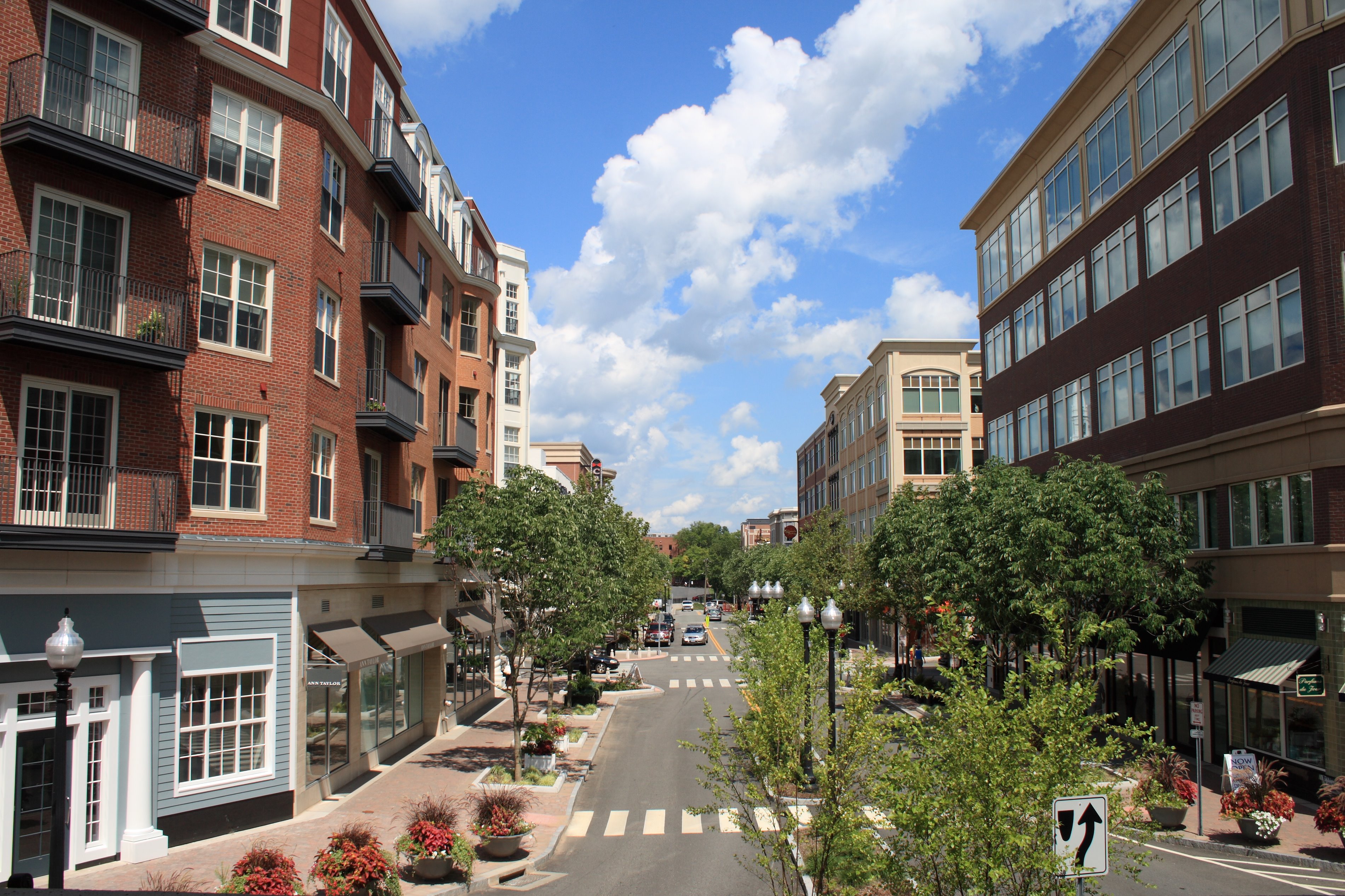
The town is known for its popular downtown area colloquially known as "West Hartford Center," or simply "The Center," which is centered on Farmington Avenue and South/North Main Street. West Hartford Center has been the community's main hub since the late 17th century. In 2008, Blue Back Square opened as a new addition to the central area.[2] Blue Back includes a bookstore, a movie theater, two parking garages, various physician and medical offices, and several restaurants.
Incorporated as a town in 1854, the town was previously a parish of Hartford, founded in 1672.[3] Among the southernmost of the communities encompassed within the Hartford-Springfield Knowledge Corridor metropolitan region, West Hartford is home to University of Hartford and the University of Saint Joseph.
In 2010, Kiplinger's Personal Finance magazine listed West Hartford as one of the nation's "10 Great Cities for Raising Families."[4] In 2010, Kiplinger's ranked West Hartford #9 on its "10 Best Cities for the Next Decade" list.[5] In 2010, CNN Money ranked West Hartford as the 55th best small city in America.[6] In 2010, the national online magazine Travelandleisure.com cited West Hartford as one of 10 "coolest" suburbs in the nation. The magazine called the West Hartford Reservoir off Farmington Avenue "West Hartford's version of Central Park,"[7] and it also noted the town's "vacation-worthy hot spots, with cutting-edge restaurants, great shopping, and plenty of parking."[8]
History[]
According to new archaeological evidence, the Wampanoag people used West Hartford as one of their winter camps. Fishing and hunting along the Connecticut River, the area of West Hartford offered the Wampanoag people a refuge from the cold winter wind and the river's severe spring flooding. In 1636 Reverend Thomas Hooker led a group of followers from what is now Cambridge, Massachusetts to the "Great River" and eventually established the Hartford Colony. As the colony grew, additional land was needed. In 1672 the Proprietors of Hartford ordered that a Division be created to the West. A total of "72 Long Lots" were laid out between today's Quaker Lane in the East and Mountain Road in the West. The northern boundary was Bloomfield, and the Southern, present day New Britain Avenue. (The western boundary was extended in 1830 to include part of Farmington). In the 1670s the area was referred to as the "West Division" of Hartford. This remained the official name until 1806 when Connecticut General Assembly started referring to it as "the Society of West Hartford."
It is believed that the first homesteader to West Hartford was Stephen Hosmer whose father was in Hooker's first group of Hartford settlers and who later owned 300 acres (1,200,000 m2) just north of the present day Center. In 1679, Stephen Hosmer's father sent him to establish a sawmill on the property. Young Hosmer would eventually go back to live in Hartford, but in his 1693 estate inventory, 310 acres (1,250,000 m2) in West Hartford along with a house and a sawmill are listed. For nearly a century the property would be handed down throughout the family. Evidence still remains of the Town's first industry, as Stephen Hosmer's mill pond and dam can still be found today on the westernmost side of North Main Street.
By the time of the American Revolution, the once rugged wilderness had been largely clear and a new agricultural-based community had developed with a population of just over 1,000 residents and 3,000 sheep. At its core was the parish meeting house. The First Congregational Meeting House was built around 1712 and still stands proudly today at what is now the northwest corner of Main Street and Farmington Avenue. As the focus of early religious, political, and social life, the meeting house helped to provide this area with a name, a title that it still holds today – "The Center."
Evidence in the Hartford Courant and in the 1790s census show that some of the more prosperous households relied on laborers and slaves for fieldwork and domestic help. The Sarah Whitman Hooker House was one such residence and still stands on New Britain Avenue. Evidence shows that the Hookers owned several slaves. One such slave, Bristow, bought his freedom in 1775 to fight in the Revolutionary War. slave for whom one of West Hartford's middle schools is named, Bristow bought his freedom from Thomas Hart Hooker in April 1775 as Hooker set off to fight in the Revolutionary War. Bristow continued to live with the family after Thomas Hart Hooker was killed in the war. Bristow became an agricultural expert and left his property to the Hookers' two children when he died. He is the only known African American to be buried in West Hartford's Old Center Burial Yard.[9]
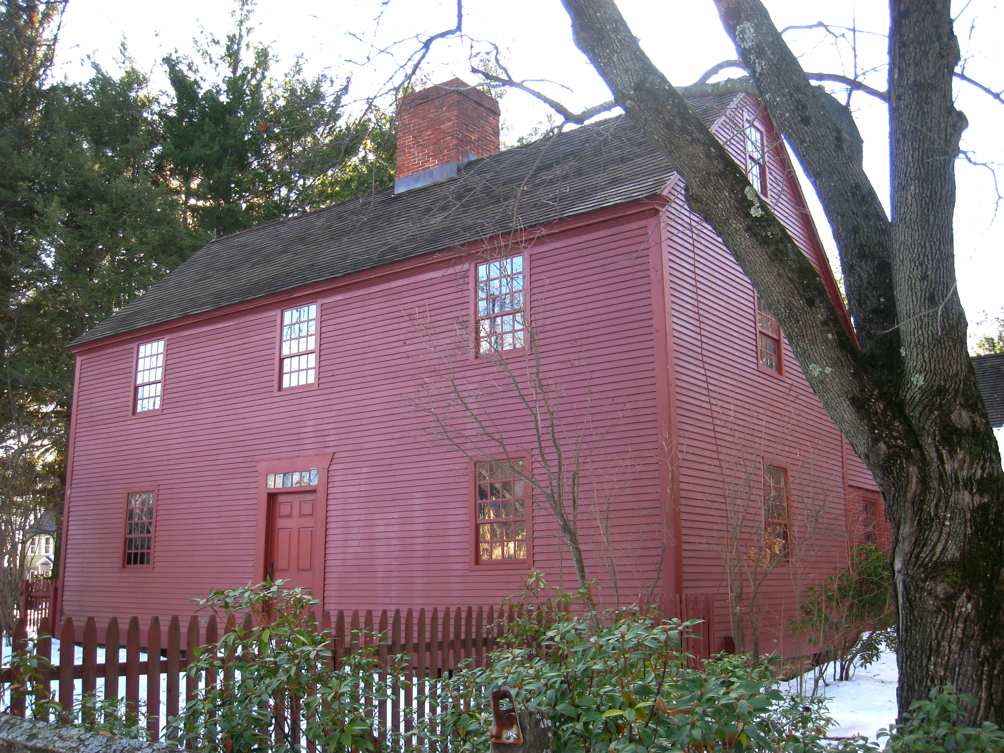
Noah Webster House (West Hartford, CT) - front facade
Coming of industry[]
One of the first major industries to arise centered on the pottery and brick works. Extending from Hartford to Berlin is a sizable deposit of fine clay. In 1770, Ebenezer Faxon came from Massachusetts and settled in what would become the Elmwood section of West Hartford. There he established a pottery on South Road (what is today New Britain Avenue) which took advantage of the local geological landscape. It was Seth Goodwin, however, who helped to establish a pottery dynasty. Goodwin started his pottery works around 1798. For over a hundred years, the Goodwin name would be associated with West Hartford pottery. Producing utilitarian items such as jugs for the gin manufactured in local distilleries, to terra cotta designs and fine china, the Goodwin Company employed up to 75 people in its heyday. The Goodwin Brothers Pottery Company (as it came to be known) burned for the third time in 1908 and never recovered.[1 1]


Sarah Whitman Hooker House in West Hartford, August 22, 2008
In 1879 Edwin Arnold established the Trout Brook Ice & Feed Company. Ice from Trout Brook, a stream that runs through the middle of West Hartford, was harvested in the winter, sawn into blocks, and placed into a series of ice houses through an escalator system. Insulated in sawdust, the blocks of ice were used as refrigeration locally and shipped as far away as New York City. By the late 19th century, the New York, New Haven & Hartford Railroad ran through part of Elmwood in the southeast corner of town. A variety of companies cropped up in this area including Whitlock Coil Pipe Company in 1891, and later Royal Typewriter, Wiremold, Abbot Ball, Colt's Manufacturing and Uncle Bill's Silver Grippers (producer of tweezers). The largest of West Hartford manufacturers was Pratt & Whitney. In 1940 it built a plant on 20 acres (81,000 m2) and at the height of World War II it employed over 7,000 people. It would stand until 1991, when Pratt & Whitney was acquired and operations were relocated to Plainville.[10]
A new town[]
In 1792 a committee of residents was appointed to ask permission from Hartford to secede, and were denied. Five years later they petitioned again and again were denied. In the spring of 1854, the Connecticut General Assembly was meeting in New Haven (co-capitol with Hartford at the time). Most likely taking advantage of the distance from Hartford, a petition dated March 21 was delivered to the General Assembly by delegates from West Hartford. Signed by 153 residents, the petition claimed that residences were "subjected to many inconveniences on account of their present connection with the town and city of Hartford and that their convenience and prosperity would be essentially promoted by being set off as a separate town." On April 26, about 100 residents from West Hartford presented their own case against secession. After review and an opportunity for Hartford to make an argument for keeping West Hartford, the General Assembly voted on May 3 for West Hartford's independence.
The 1854 vote was not however the end of the debate. In 1895 wealthy residents from the "East Side" of West Hartford petitioned Hartford for annexation. Their call was rebuffed by other West Hartford residents. Then in 1923 and 1924 Hartford wanted to annex West Hartford back so that it could achieve a "Greater Hartford Plan." Town residents rallied in opposition and the plan was defeated by a vote of 2,100 to 6137.[11]
Emergence as a streetcar suburb[]
It is transportation that has had the biggest impact on West Hartford and its evolution from sleepy crossroads to modern suburb. In the late 18th and early 19th century three turnpikes ran through West Hartford. Around these roads, taverns, blacksmith and wheelwright shops, general stores and many other places of businesses sprang up. Early maps provide a sense of how important these byways were in the development of commerce and industry. Then came the trolleys – starting in 1845, Fred Brace began running a horse-drawn omnibus from his home on the corner of Farmington Avenue and Dale Street into downtown Hartford. Even more significant were the horse-drawn trolley lines and later electric trolleys that in 1889 began to weave their way from the inner city of Hartford to the countryside of West Hartford. Trolley lines opened up a land that had been inaccessible to many, and made it possible for professionals and their families to settle along Prospect Avenue, then north of Farmington Avenue.
By the 1880s, Hartford began to experience an economic boom. As such Hartford’s business leaders began building their mansions along Prospect Avenue. Prospect Hill, situated on a mile-long ridge boasting impressive views of the burgeoning city, became the area's most prestigious address. Homes are characteristic of the architectural styles popular in that period are represented, particularly Late 19th and 20th Century Revivals. Many homes in the area on the National Register of Historic Places, including the Connecticut Governor's Residence, built in 1908. Prospect Avenue is adjacent to Hartford, designed by acclaimed landscape architect Frederick Law Olmsted in 1896 and named for the wife of Governor Charles H. Pond, who bequeathed the land to the City of Hartford. In 1900, the Hartford Golf Club opened its links on the other side of Asylum Avenue just west of Prospect Avenue, adding to the area's ideal suburban sensibility.[12]
In 1895, Wood, Harmon and Company created one of the town's first subdivisions on property known as Stanley Farm, a tract sloping upward from the trolley line that then ran along Farmington Avenue, across from Reservoir No. 1. Called Buena Vista, it was promoted it "Hartford's New and Handsome Suburb." Their literature highlighted "splendid suburban electric car service" and proximity to Reservoir No. 1.[13]


West Hill Historic District in West Hartford 2
Other developments followed including "Elmhurst" in Elmwood (1901), and Sunset Farm (1917). One of the most exclusive of these early developments was West Hill. Located on the former estate of Cornelius Vanderbilt, son of the famous financier and transportation magnet, it was the brainchild of Horace R. Grant. Designed by some of Hartford's best architects in the 1920s, West Hill is significant historically because it is an excellent example of a planned real estate development of the early 1920s that proceeded under specific design restrictions to achieve outstanding success as a well-crafted and prestigious neighborhood. The architecture is characteristic of the Colonial Revival and Tudor Revival styles popular in the period. It was declared a National Historic District in 1996.[14]
The automobile[]

Old Noah Webster Memorial Library building, August 14, 2008
By the 1920s and 30s the impact of the automobile was felt in West Hartford as the town became more accessible to Hartford's middle and working class citizens. Between 1910 and 1930 the population of West Hartford grew from 4,808 to 24,941 residents. Then with the end of the Great Depression, World War II, and the exodus from urban centers, West Hartford witnessed a tremendous influx of people as its population swelled from 33,776 in 1940 to 62,382 people by 1960. This era ushered in major housing developments and retail spaces throughout the community.
In the 50s, the primary avenues — Albany, Asylum and Farmington — became important arteries for commuters, and the access made West Hartford attractive to middle-class families. During the decade, the town built one new elementary school each year to accommodate the growing population. In the 1960s, construction began on Interstate 84, completed in 1969. The interstate had many ramifications on the community, the most visible was that it bisected the town, isolating the more industrial and ethnically diverse neighborhood of Elmwood with a physical barrier from the rest of West Hartford.[15] Furthermore, The interstate allowed for increased accessibility as the population increased with the Baby Boom and development, and recalibrated the traditional retail sites.
Subsequent residential development continued on through the late '70s, particularly in the town's northern, western and far southwestern fringes, as evidenced by the many large ranch, colonial and split level-style homes in these areas. In 1971, the Bishops Corner development was inaugurated. Housing tenants such as Lord & Taylor, F.W. Woolworth, and Doubleday Book Shop drew shoppers from across the region; the Center with its largely independently owned stores, were negatively impacted by the new retail traffic patterns.[16]
Towards the town's southwest fringe lies Westfarms Mall. Opened in 1974 with original anchors JC Penney, G. Fox & Co., and Sage-Allen, the mall further recalibrated retail in West Hartford. It became well known for its lavish ceilings and waterfall-style fountain. Sitting astride I-84, conveniently connected to the town’s main internal arteries, and comprising more than 1,300,000 square feet (120,000 m2) of stores and restaurants, it is the third largest indoor mall in Connecticut.[17]


Outside the library at Blue Back Square in West Hartford, Connecticut, August 10, 2008
Blue Back Square[]
In recent years, large areas of the community have gone through significant transformations. Opening in 2007, Blue Back Square was a pioneer mixed-use development in the Center that blended retail and residential living space on a large scale. The five-building complex contains 220,000 square feet (20,000 m2) of ground floor retail space and 120 luxury space. Medical office space encompasses 137,000 square feet (12,700 m2), and other professional offices will total another 62,500 square feet (5,810 m2) square feet. A six-screen movie theatre as well as two 500-space parking garages were also built.[18] Named after Noah Webster's popular spelling book, Blue-Back Speller, the development has significantly altered the Center and furthered West Hartford's status as a regional dining and shopping destination.[19]
Geography[]


American Beech Tree, West Hartford, CT
According to the United States Census Bureau, the town has a total area of 22.3 square miles (57.7 km2), of which 21.9 square miles (56.6 km2) is land and 0.42 square miles (1.1 km2), or 1.91%, is water.[1]
The west side of West Hartford is flanked by the Metacomet Ridge, a mountainous trap rock ridgeline that stretches from Long Island Sound to nearly the Vermont border. Notable features of the Metacomet Ridge in West Hartford include Talcott Mountain and a number of highland water reservoirs belonging to the Metropolitan District, which maintains watershed and recreation resources on the property. The 51-mile-long (82 km) Metacomet Trail traverses the ridge. The town's web site indicates that the highest point in town is 778 feet (237 m) above sea level on Talcott (Avon) Mountain. The altitude at Town Hall is 120 feet (37 m).
West Hartford is adjacent to and west of Hartford, the state capital, and borders Bloomfield, Newington, New Britain, Farmington, and Avon. West Hartford is approximately 100 miles (160 km) southwest of Boston and 120 miles (190 km) northeast of New York City. Interstate 84 runs through West Hartford.
Demographics[]
| Historical populations | |||
|---|---|---|---|
| Census | Pop. | %± | |
| 1860 | 1,296 | ||
| 1870 | 1,533 | 18.3% | |
| 1880 | 1,828 | 19.2% | |
| 1890 | 1,930 | 5.6% | |
| 1900 | 3,186 | 65.1% | |
| 1910 | 4,808 | 50.9% | |
| 1920 | 8,854 | 84.2% | |
| 1930 | 24,941 | 181.7% | |
| 1940 | 33,776 | 35.4% | |
| 1950 | 44,402 | 31.5% | |
| 1960 | 62,382 | 40.5% | |
| 1970 | 68,031 | 9.1% | |
| 1980 | 61,301 | −9.9% | |
| 1990 | 60,110 | −1.9% | |
| 2000 | 63,589 | 5.8% | |
| 2010 | 63,268 | −0.5% | |
| Est. 2014 | 63,324 | [20] | −0.4% |
| Historical population of West Hartford[22] | |
| 1850 | 4,411[23] |
| 1860 | 1,296 |
| 1870 | 1,533 |
| 1880 | 1,828 |
| 1890 | 1,930 |
| 1900 | 3,186 |
| 1910 | 4,808 |
| 1920 | 8,854 |
| 1930 | 24,941 |
| 1940 | 33,776 |
| 1950 | 32,402 |
| 1960 | 62,382 |
| 1970 | 68,031 |
| 1980 | 61,310 |
| 1990 | 60,421 |
| 2000 | 63,589 |
| 2010 | 63,268 |
As of the 2010 Census,[24] there were 63,268 people, 25,258 households, and 16,139 families residing in the town. The population density was 2,888.9 people per square mile (1,117.0/km²). There were 25,332 housing units at an average density of 1,152.3/square mile (445.0/km²). The racial makeup of the town was 79.6% White, 6.3% African American, 0.2% Native American, 7.4% Asian, 0.03% Pacific Islander, 3.8% from other races, and 2.7% from two or more races. Hispanic or Latino of any race were 9.8% of the population.
Of West Hartford residents, 49.85% are religious. Out of all residents, 31.74% are Catholic, 3.29% are Presbyterian, 2.19% are Baptist, 2.19% are Methodist, 1.59% are Jewish, 1.39% are Lutheran, 1.31% are Episcopalian, 1.19% are Pentecostal, .4% are Mormon, 3.38% are another Christian denomination, and .34% are Muslim.[25]
There were 25,258 households out of which 30.5% had children under the age of 18 living with them, 50.7% were married couples living together, 10.3% had a female householder with no husband present, and 36.1% were non-families. 29.1% of all households were made up of individuals and 13.1% had someone living alone who was 65 years of age or older. The average household size was 2.42 and the average family size was 3.06.
In the town, the population was spread out with 23.3% under the age of 18, 9.8% from 18 to 24, 24.2% from 25 to 44, 28.1% from 45 to 64, and 17.1% who were 65 years of age or older. The median age was 41.5 years. For every 100 females there were 86.5 males. For every 100 females age 18 and over, there were 82.2 males.
The median income for a household in the town was $80,061, and the median income for a family was $106,089 as of a 2011 estimate.[26] Males had a median income of $69,888 versus $56,162 for females. The per capita income for the town was $45,453. About 3.7% of families and 6.1% of the population were below the poverty line, including 5.3% of those under the age of 18 and 9.6% ages 65 or older.
Government[]
West Hartford has been governed via the council–manager government since 1919. West Hartford was the first town in the state and one of the first in the country to adopt this form of government where the council acts as the elected policy board and the town manager serves as the chief executive officer responsible for carrying out the policies of the council. Town Council members are elected at large for two years and represent all of West Hartford and the town clerk is elected for four years. Elected by the Town Council in 2008, Ronald F. Van Winkle is the Town Manager.[27]
Connecticut municipalities (like those of neighboring states Massachusetts and Rhode Island) provide nearly all local services (such as fire and rescue, education, snow removal, etc.), as county government has been abolished since 1960.[28]
Transportation[]
Airports[]
Bradley International Airport, in Windsor Locks, Connecticut, is twenty minutes north of downtown Hartford. It features over 150 daily departures to over 30 destinations on nine airlines. Other airports serving the Hartford area include:[29]
- Hartford-Brainard Airport, located in Hartford off I-91 and close to Wethersfield, serves charter flights and local flights.
- Westover Metropolitan Airport, located in Chicopee, Massachusetts, 27 miles (43 km) north of Hartford, serves commercial, local, charter, and military flights.
- Tweed New Haven Regional Airport, located in New Haven, Connecticut, is served by US Airways Express.
Railroad[]
Although Amtrak does not currently serve West Hartford directly, the town center is located approximately 5 miles (8.0 km) west of Hartford's Union Station.
Additionally, West Hartford is a planned stop along the Hartford Line, a commuter rail service from New Haven to Springfield that will use the current Amtrak line, with a possible shuttle bus connection in Windsor Locks for Bradley International Airport. As of December 2015, funding has been secured to finance the construction of the new line, with service scheduled to begin in early 2018.[30] The State of Connecticut has secured funding for the construction of a new train station at Flatbush Ave, at the corner of Flatbush Avenue and New Park Avenue.[31]
Bus rapid transit[]
In March 2015, CTfastrak, Connecticut's first bus rapid transit corridor opened, providing a separated right-of-way between Hartford and New Britain.[32] West Hartford is served by two stations:
- Elmwood - Corner of New Park Avenue and New Britain Avenue
- Flatbush Ave - Corner of Flatbush Avenue and New Park Avenue
Buses[]
West Hartford is served by several bus routes of Connecticut Transit. Major roads served are Albany Avenue (Route 58), New Britain Avenue (Routes 37, 39, and 128), Park Street (Routes 31 and 33), South/North Main Street (Route 153) Farmington Avenue (Routes 60, 62, 64, and 66), Asylum Avenue (Route 72), Hillside Avenue (Route 63), and Boulevard/South Quaker Lane (Route 69).
Highways[]
I-84, which runs from Scranton, to its intersection with I-90 in Sturbridge, just over the Massachusetts border passing through West Hartford. In addition, Hartford is served by the following:
 US 44
US 44- Template:Jct/2
- [[Template:Infobox road/CT/link Route|Template:Infobox road/CT/abbrev Route]]
- [[Template:Infobox road/CT/link Route|Template:Infobox road/CT/abbrev Route]]
- [[Template:Infobox road/CT/link Route|Template:Infobox road/CT/abbrev Route]]
- [[Template:Infobox road/CT/link Route|Template:Infobox road/CT/abbrev Route]]
- [[Template:Infobox road/CT/link Route|Template:Infobox road/CT/abbrev Route]]
- [[Template:Infobox road/CT/link Route|Template:Infobox road/CT/abbrev Route]]
- [[Template:Infobox road/CT/link Route|Template:Infobox road/CT/abbrev Route]]
Economy[]
Top employers[]
According to the town's 2010 Comprehensive Annual Financial Report,[33] the top employers in the city are:
| # | Employer | # of Employees |
|---|---|---|
| 1 | Town of West Hartford | 1,000–2,000 |
| 2 | University of Hartford | 1,000–2,000 |
| 3 | Hebrew Health Care | 500–999 |
| 4 | Wiremold | 500–999 |
| 5 | Goodrich | 250–499 |
| 6 | University of Connecticut | 250–499 |
| 7 | American Medical Response | 250–499 |
| 8 | The Cheesecake Factory | 250–499 |
| 9 | Saint Mary Home | 250–499 |
| 10 | Colt's Manufacturing Company | 250–499 |
Educational institutions[]
In 2006 Money magazine ranked West Hartford as the 10th most educated town in the United States, as measured by the percentage of town residents holding graduate or professional degrees.[34] Connecticut Magazine 2006 rankings put West Hartford Public School education in the top three among all cities and towns in Connecticut for its population class of greater than 50,000 people, behind only Greenwich and Fairfield.[35]
Public schools[]

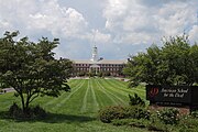
The American School for the Deaf
The town is home to two public high schools, Conard High School (home of the Conard Chieftains) and Hall High School (home of the Hall Warriors), as well as 11 elementary schools and three middle schools in the West Hartford Public Schools. The elementary schools are Aiken, Braeburn, Bugbee, Charter Oak, Duffy, Morley, Norfeldt, Smith, Webster Hill, Whiting Lane and Wolcott. The three middle schools are King Philip, Sedgwick, and the newest, Bristow Middle School, located where Kingswood-Oxford Middle School was formerly located. The eleven elementary schools are evenly distributed to either King Philip or Sedgwick, and those that enroll at Bristow are chosen by lottery. After middle school, students continue onto high school with their same student body. Those at Sedgwick go on to Conard High School, while those at King Philip go to Hall High School, and students at Bristow return to the same school district they were in during elementary school.
Private schools[]
- Saint Thomas the Apostle Elementary School
- Saint Timothy Middle School
- Northwest Catholic High School
- Saint Brigid Elementary School
- American School for the Deaf
- Kingswood-Oxford School
- Renbrook School
- Hebrew High School of New England
- Solomon Schechter Day School
- German School of Connecticut
Colleges and universities[]


White Oak Tree, West Hartford, CT
Institutions of higher learning located in town include the following colleges and universities:
- University of Hartford
- University of Saint Joseph
- University of Connecticut Greater Hartford Campus
Media[]
- The Jewish Ledger, weekly newspaper
- West Hartford Life, monthly newspaper
- West Hartford News, weekly newspaper
- West Hartford Press, weekly newspaper
- Radio
- WNWW
- WWUH
- WNPR
- TV
Utilities serving the town[]
- Electricity: Connecticut Light & Power
- Water: Metropolitan District Commission
- Natural gas: Connecticut Natural Gas
- Telephone, ADSL/Fiber internet, IPTV television: Frontier Communications
- Cable television/Cable internet: Comcast
Notable people[]


Noah Webster statue by West Hartford sculptor Korczak Ziółkowski
In alphabetical order:
- Chip Arndt, gay rights activist, philanthropist, and co-winner of The Amazing Race 4
- Stephen Barnett (1935–2009), legal scholar who opposed the Newspaper Preservation Act of 1970[36]
- Michelle Beadle, Sports Reporter and NBC Universal Host
- E. Alexander Bergstrom (1919–73), conservationist
- Manute Bol (1962–2010), NBA player
- Ben Bova, science fact and fiction author
- Chris Carrabba, singer–songwriter from Dashboard Confessional
- Joyce Cohen, actress
- John Droney, politician and lawyer
- Dominick Dunne (1925–2009) and John Gregory Dunne, (1932–2003), writers, were born in Hartford and grew up in West Hartford
- John Franklin Enders, Nobel Laureate 1954 for Medicine
- Joe Furey, Chief Meteorologist Fox61
- Adam Greenberg, 2-time Chopped champion
- Martin Hayes, Six Time All Ireland Fiddle Champion
- Katharine Houghton Hepburn (1878–1951), social activist
- Liz Janangelo, professional golfer on the LPGA Tour
- Jared Jordan, drafted 45th by Los Angeles Clippers in the 2007 NBA Draft
- Tim Brennan, guitar player and songwriter for Dropkick Murphys
- Edward Lorenz, mathematician and meteorologist, early pioneer of chaos theory, inventor of the strange attractor notion, made the term "butterfly effect" popular
- Frank Luntz, Republican pollster
- Joseph Mascolo, actor and soap opera veteran
- Brett H. McGurk, Special Adviser to the United States Ambassador to Iraq
- Edward Morley, namesake of Morley Elementary School, scientist best known for the Michelson–Morley experiment
- John O'Hurley, actor on Seinfeld television series
- Peter Paige, actor
- John P. Reese, money manager and financial columnist
- William Thompson Sedgwick, professor at the Massachusetts Institute of Technology and a key figure in shaping U.S. public health
- Noah Webster, lexicographer, textbook author, Bible translator, spelling reformer, writer, and editor
- John Woodruff, congressman
- Korczak Ziolkowski (1908–82), sculptor of Crazy Horse Memorial in South Dakota
Conard graduates[]
- Veronica Belmont, online media personality
- Marcus Camby, professional basketball player (attended Conard but graduated from Hartford High School)
- Peter Dante, actor
- Kevin Galvin, business/health care advocate
- David Naughton, class of 1969, actor (An American Werewolf in London)
- James Naughton, actor, winner of the Tony Award for Best Performance by a Leading Actor in a Musical (1990, 1997)
- Robert Romanus, actor (Fast Times at Ridgemont High), class of 1974
- Jimmy Shea, class of 1987, gold medalist in the 2002 Winter Olympics
- Matt Sinatro, class of 1978, Major League Baseball player and coach
- Jack Sonni, guitarist from Dire Straits (1985–1988)
Hall graduates[]
- David Alan Basche, actor (United 93, War of the Worlds)
- Debora Cahn, writer and producer
- Wavy Gravy, peace activist and "official clown" of the Grateful Dead
- Grayson Hugh, singer/songwriter, pianist, "Blind To Reason" (RCA 1988), "Road To Freedom" (MCA 1992), "An American Record" (Swamp Yankee Records 2010), "Back To The Soul" (Swamp Yankee Records 2015), songs in movies Thelma and Louise and Fried Green Tomatoes
- Charlie Kaufman, Academy Award-winning screenwriter (Eternal Sunshine of the Spotless Mind, Adaptation, Being John Malkovich)
- Brad Mehldau, jazz pianist
- Brian Rosenworcel, musician and member of the band Guster
- Sara Roy, Middle East scholar
- Michael Schur, writer and producer (The Office, Saturday Night Live, Parks & Rec)
- Scott Slifka, West Hartford mayor
- Roger Sperry (1913–94), neuropsychologist and Nobel Prize laureate
- David H. Steinberg, screenwriter (Slackers, National Lampoon's Barely Legal)
Points of interest[]

Blue Back Square
- Bishops Corner
- Blue Back Square
- Elizabeth Park
- Elmwood
- Fern Park
- Noah Webster House
- Park Road
- West Hartford Center
- Westfarms Mall
- Westmoor Park

|
Avon | Bloomfield |
| |
| Farmington | Hartford | |||
 West Hartford, Connecticut | ||||
| New Britain | Newington |
See also[]
- National Register of Historic Places listings in West Hartford, Connecticut
References[]
- ^ a b "Geographic Identifiers: 2010 Demographic Profile Data (G001): West Hartford town, Hartford County, Connecticut". U.S. Census Bureau, American Factfinder. http://factfinder2.census.gov/bkmk/table/1.0/en/DEC/10_DP/G001/0600000US0900382590. Retrieved November 28, 2012.
- ^ Blue Back Square
- ^ https://www.noahwebsterhouse.org/discover/
- ^ "10 Great Cities for Raising Families". Kiplinger.com. August 31, 2010. http://www.kiplinger.com/features/archives/10-great-cities-for-raising-families.html#ixzz0yCGo1cPY. Retrieved March 17, 2011.
- ^ "10 Best Cities for the Next Decade". Kiplinger.com. http://www.kiplinger.com/magazine/archives/10-best-cities-2010-for-the-next-decade.html. Retrieved March 17, 2011.
- ^ "Best Places to Live 2010". CNN. http://money.cnn.com/magazines/moneymag/bplive/2010/top100/index3.html.
- ^ "Coolest Suburbs Worth a Visit- Page 9 – Articles | Travel + Leisure". Travelandleisure.com. http://www.travelandleisure.com/articles/coolest-suburbs-worth-a-visit/9. Retrieved March 17, 2011.
- ^ "Magazine Cites West Hartford As One Of The Coolest Suburbs – Hartford Courant". Courant.com. August 4, 2010. http://www.courant.com/community/west-hartford/hc-west-hartford-another-award-0805-20100804,0,1350520.story. Retrieved March 17, 2011.
- ^ Stagis, Julia (10 July 2013). "Study: Historic House Needs $200,000 Of Work". The Hartford Courant. http://articles.courant.com/2013-07-10/community/hc-west-hartford-sarah-hooker-house-0703-20130701_1_historic-house-noah-webster-house-boarding-house. Retrieved 5 April 2015.
- ^ Pratt & Whitney. "History". http://www.prattandwhitney.com/Content/History.asp. Retrieved 5 April 2015.
- ^ Burr, Nelson (1976). From Colonial Parish to Modern Suburb: Brief Appreciation of West Hartford (1st ed.). The Noah Webster Foundation and Historical Society of West Hartford. pp. 42–45.
- ^ (1895) "The Connecticut Magazine". The Connecticut Quarterly Company 1 (2): 132–135. Retrieved on 5 April 2015.
- ^ Jacobs, Gerald (21 Oct 1995). "West Hartford Subdivision Reaches Milestone". The Hartford Courant. http://articles.courant.com/1995-10-21/news/9510210504_1_real-estate-lots-buyers. Retrieved 5 April 2015.
- ^ Clark, Marlene (12 Mar 2008). "A Place Grand Enough For The Vanderbilts To Call Home". The Hartford Courant. http://articles.courant.com/2008-03-12/news/0803110681_1_hartford-area-fortune-s-children-mansion. Retrieved 5 April 2015.
- ^ Prevost, Lisa (4 May 2008). "A Revival in a Run-Down Part of Town". The New York Times. http://www.nytimes.com/2008/05/04/realestate/04wczo.html. Retrieved 5 April 2015.
- ^ Adam, Stuhlman (25 March 2011). "The story behind Bishops Corner". West Hartford News. http://www.westhartfordnews.com/articles/2011/03/25/news/doc4d8c3765233bc681432156.txt?viewmode=fullstory. Retrieved 5 April 2015.
- ^ http://www.easternct.edu/~pocock/MallsConn.htm
- ^ Gordon, Jane (20 Dec 2006). "A Suburb’s Big Project Is Outpacing Hartford’s". The New York Times. http://www.nytimes.com/2006/12/20/realestate/commercial/20conn.html. Retrieved 5 April 2015.
- ^ Seay, Gregory (1 June 2012). "Blue Back's success secret | An old-style village repackaged as 'new urbanism'". Hartford Business Journal. http://www.hartfordbusiness.com/article/20110919/PRINTEDITION/309199992/blue-backs-success-secret--an-old-style-village-repackaged-as-new-urbanism. Retrieved 5 April 2015.
- ^ "Annual Estimates of the Resident Population for Incorporated Places: April 1, 2010 to July 1, 2014". http://www.census.gov/popest/data/cities/totals/2014/SUB-EST2014.html. Retrieved June 4, 2015.
- ^ "Census of Population and Housing". Census.gov. http://www.census.gov/prod/www/decennial.html. Retrieved June 4, 2015.
- ^ [1][2][3]
- ^ Figure represents population in the Town of Hartford outside the City of Hartford.
- ^ "American FactFinder". United States Census Bureau. http://factfinder2.census.gov. Retrieved 2008-01-31.
- ^ "West Hartford, Connecticut Religion". http://www.bestplaces.net/religion/city/connecticut/west_hartford.
- ^ "United States – Fact Sheet – American FactFinder". Factfinder.census.gov. http://factfinder2.census.gov/faces/tableservices/jsf/pages/productview.xhtml?pid=ACS_11_5YR_DP03. Retrieved Feb 27, 2013.
- ^ "Town Council". West Hartford. https://www.westhartfordct.gov/gov/town_council/default.asp. Retrieved 5 April 2015.
- ^ "Connecticut Ends County Rule Oct. 1; State to Take Over Historic Government Units – Minor Court System Also to Go". The New York Times. 1960-08-14. http://select.nytimes.com/gst/abstract.html?res=F70A10FA355A1A7A93C6A81783D85F448685F9. Retrieved 2010-05-20.
- ^ "Destinations". Bradleyairport.com. 2010-04-05. http://www.bradleyairport.com/Flights/destinations.aspx. Retrieved 2012-06-09.
- ^ Stacom, Dan (4 December 2015). "Springfield-To-New Haven Commuter Rail Cost Increases, Service Begins In 2018". Hartford Courant. http://www.courant.com/news/connecticut/hc-amtrak-hartford-line-1204-20151204-story.html. Retrieved 5 December 2015.
- ^ Newton, Ronnie (13 January 2015). "Rail Station To Be Built in West Hartford". We-Ha.com. http://we-ha.com/rail-station-to-be-built-in-west-hartford/. Retrieved 5 December 2015.
- ^ Staggs, Julie (14 Mar 2013). "Busway Construction Will Impact Traffic On Flatbush Avenue". The Hartford Courant. http://articles.courant.com/2013-03-14/community/hc-west-hartford-busway-0315-20130314_1_ctfastrak-million-busway-michael-mendick. Retrieved 5 April 2015.
- ^ "Microsoft Word – {330929A0-A9BC-48EC-BF82-26592FDE0A9B}.doc" (PDF). http://www.west-hartford.com/TownServices/BUDGET/OTHER_FINANCIAL_INFO/2010_CAFR.pdf. Retrieved March 17, 2011.
- ^ "Best Places to Live– Most educated". CNN Money (Cable News Network). 2006. http://money.cnn.com/magazines/moneymag/bplive/2006/top25s/educated.html. Retrieved June 11, 2007.
- ^ "Rating the Towns 2006: Population Over 50,000". Connecticut Magazine. December 4, 2006. http://www.zwire.com/site/news.cfm?newsid=17547448&BRD=2329&PAG=461&dept_id=487245&rfi=6. Retrieved June 11, 2007.
- ^ Grimes, William. "Stephen Barnett, a Leading Legal Scholar, Dies at 73", The New York Times, October 21, 2009. Accessed October 22, 2009.
- ^ Faude, Wilson (2004). West Hartford. Arcadia Publishing. p. 64. ISBN 0738534862.
External links[]
| Wikivoyage has a travel guide for West Hartford. |
- West Hartford History
- Town of West Hartford official website
- West Hartford Center
- West Hartford Community Television
- Yearbook Pictures of Conard and Hall High School Famous Alumni
| ||||||||||||||||||||
| |||||||||||||

_-_front_facade.jpg)
| ||||||||||||||||||||
| This page uses content from the English language Wikipedia. The original content was at West Hartford, Connecticut. The list of authors can be seen in the page history. As with this Familypedia wiki, the content of Wikipedia is available under the Creative Commons License. |