| ||||||||||||||
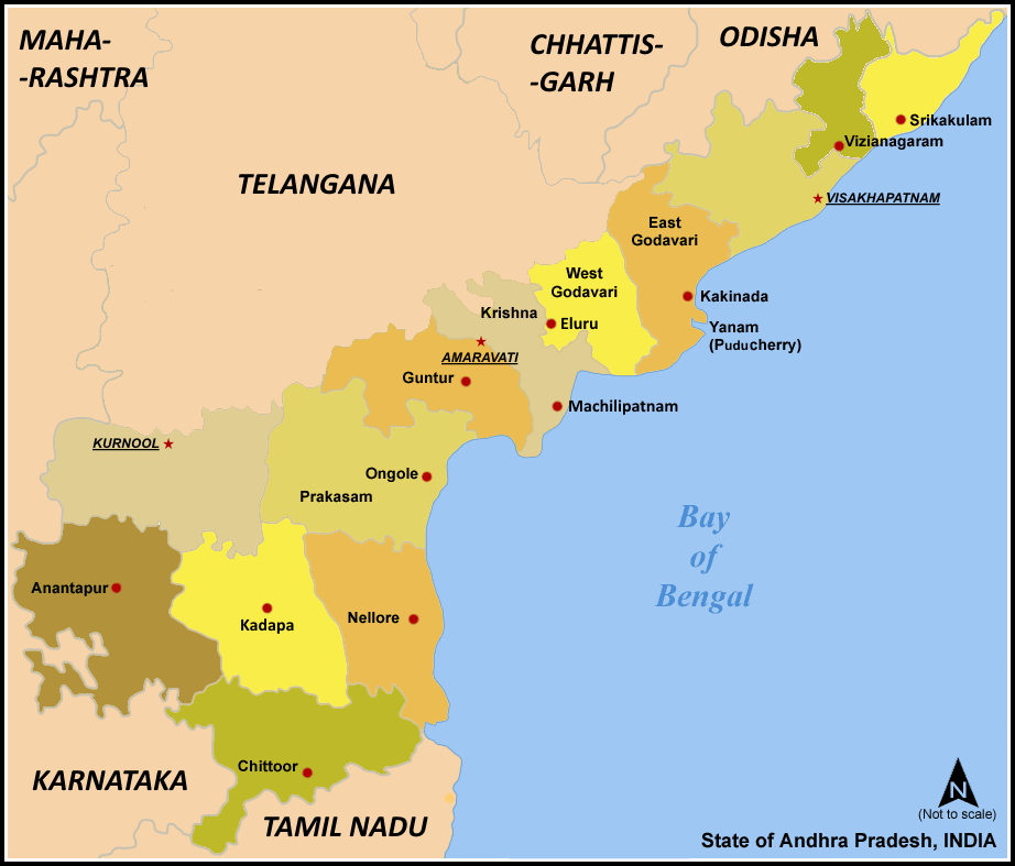
Warangal District (Telugu: వరంగల్ జిల్లా, Urdu: وارنگل ضلع) is located in the northern area in the state of Andhra Pradesh, India. The administrative seat is Warangal.
Warangal District has an area of 12,846 km², and a population of 3,246,004 of which 19.20% was urban as of 2001.[1] The district is bounded by Karimnagar District to the north, Khammam District to the east and southeast, Nalgonda District to the southwest, and Medak District to the west. Warangal is well known for its granite quarries (notably the black and brown varieties) and as a market for rice, chilies, cotton, and tobacco.
The Warangal district headquarter is Warangal city. This city is also called as tri-city, as it includes Warangal, Hanamkonda and Kazipet cities.
Warangal has been recently in the news because of the Separate Telangana issue. It has been a major centre for the movement and its rebirth. Kaloji Narayana Rao is a freedom fighter and a well known writer from Telangana.
History[]

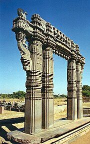
One of the Kirti toranas of Kakatiya Dynasty

1000 pillar temple at Warangal
Warangal was the capital of Kakatiya kingdom ruled by the Kakatiya dynasty from the 12th to the 14th centuries. The old name of this newly formed city is Orugallu. Oru means one and Kallu means stone.
Kakatiya sculpture at Warangal
The Kakatiyas left many monuments, including an impressive fortress, four massive stone gateways, the Swayambhu temple dedicated to Shiva, and the Ramappa temple situated near Ramappa Lake. The cultural and administrative distinction of the Kakatiyas was mentioned by the famous traveller Marco Polo. Famous or well-known rulers included Ganapathi Deva, Prathapa Rudra, and Rani (queen) Rudrama Devi. After the defeat of PratapaRudra, the Musunuri Nayaks united seventy two Nayak chieftains and captured Warangal from Delhi sultanate and ruled for fifty years. Jealousy and mutual rivalry between Nayaks ultimately led to the downfall of Hindus in 1370 A.D. and success of Bahmanis. Bahmani Sultanate later broke up into several smaller sultanates, of which the Golconda sultanate ruled Warangal. The Mughal emperor Aurangzeb conquered Golconda in 1687, and it remained part of the Mughal empire until the southern provinces of the empire split away to become the state of Hyderabad in 1724 which included the Telangana region and some parts of Maharashtra and Karnataka. Hyderabad was annexed to India in 1948, and became an Indian state. In 1956 Hyderabad was partitioned as part of the States Reorganization Act, and Telangana, the Telugu-speaking region of Hyderabad state which includes Warangal, became part of Andhra Pradesh.
Warangal District is currently a part of the Red Corridor.[2]
Geography[]
Warangal district occupies an area of 12,846 square kilometres (4,960 sq mi),[3] comparatively equivalent to the Phillippines' Samar Island.[4]
Economy[]
In 2006 the Indian government named Warangal one of the country's 250 most backward districts (out of a total of 640).[5] It is one of the thirteen districts in Andhra Pradesh currently receiving funds from the Backward Regions Grant Fund Programme (BRGF).[5]
Power sector[]
APGENCO has set up a 500 MW (and another unit of 1x600MW unit is under construction, thus the total capacity will become 1100MW) super thermal power plant in the Chelpur/ Bhupalpally area. Power Grid Corporation of India Limited is having a 630MVA, 400/220KV Substation in the Oglapur village in Atmakur mandal.,
Business and industry[]
- IT/ITES hardware
In 2001 Software Technology Parks of India started its branch in NIT Warangal premises to issue single window facilities, fast track permissions to IT, ITES companies & hardware parks so that IT/ITES parks can be established easily.
IT SEZ is also being set up by APIIC and K Raheja Group in Madikonda/Rampur area on the outskirts of Kazipet Town
Singareni coalaries have vast coal fields in the northern part of the district.
- Textiles
This district is famous for producing cotton. Cotton ginning is done here and supplied to places like Mumbai and Coimbatore.
This Place is Famous For textile production in Ancient times By the then ruler As AZAM jahi Spinning mills Which were later closed Due To HUge Commercial LOSS
- Food processing
The district is home to the Regional Research Center of the Acharya N. G. Ranga Agricultural University. This district is famous for red chilly exports. Most of the chilly exports go to Nagpur, Mumbai and Pune. Watermelon, Musk melon and Gherkins are grown in the district. Nekkonda, Dornakal, Torrur and Mahabubabad are known for Mango gardens. Vegetables are supplied to Visakhapatnam, Chennai, Vijayawada, Bangalore, Nagpur and Hyderabad.
Household indicators[]
In 2007–2008 the International Institute for Population Sciences interviewed 956 households in 40 villages across the district.[6] They found that 94.1% had access to electricity, 94.3% had drinking water, 40.6% toilet facilities, and 30.4% lived in a pucca (permanent) home.[6] 17.5% of girls wed before the legal age of 18[7] and 87.2% of interviewees carried a BPL card.[6]
Divisions[]
One of the Kirti toranas of Kakatiya Dynasty
Mandals include:
|
1. Cheriyal |
18. Thorrur |
36. Duggondi |
Transport[]
- Road transport
National Highway 202 (India) between Hyderabad - Bhopalpatnam (Chhattisgarh) connecting the district through Jangaon, Kazipet, Hanamkonda, Mulug, Eturnagaram. Warangal city is surrounded with towns like Bhoopalpally , Parkal, Mahabubabad, Narsampet, Torrur and Jangaon each 30-90 kilometers.
Warangal is about 140 km by road from Hyderabad (capital of Andhra Pradesh).
- Rail transport
The city has to Railway stations called (Warangal and Kazipet) which connects south and north India and the Kazipet is major railway junction.
- Airport
Hyderabad International Airport is about 3 ½ hours by road from Warangal city. This district has a small airport in Mamnoor, which can accommodate small aircraft like the ATR 42. This airport is currently used by police.
Demographics[]
According to the 2011 census Warangal district has a population of 3,522,644 ,[8] roughly equal to the nation of Lithuania[9] or the US state of Connecticut.[10] This gives it a ranking of 82nd in India (out of a total of 640).[8] The district has a population density of 274 inhabitants per square kilometre (710 /sq mi) .[8] Its population growth rate over the decade 2001-2011 was 8.52 %.[8] Warangal has a sex ratio of 994 females for every 1000 males,[8] and a literacy rate of 66.16 %.[8]
Culture[]
The district hosts the Samakka-Saramma Jatara (congregation). Every two years, approximately ten million people converge over three days around the small village of Tadvai, 90 km from Warangal city. This fair commemorates the valiant fight put up by a mother-daughter combination with the reigning rulers over an unjust law.
Warangal is an excellent abode of fine arts and literature. Many art forms from folklore to the modern arts of singing, dance, painting, poetry and films have been flourished in the land.
Education[]
Some of the major educational institutions in this district are:
- Kakatiya University(Official Website)
- National Institute of Technology, Warangal (formerly REC Warangal — One of the top ranked advanced premium technical education institutes in India)
- Kakatiya Medical College – A medical education institute which has a 1000 bed general hospital attached to it.
There are several engineering colleges situated around the city, producing thousands of engineering students every year.
Schools[]
- St. Paul's High School, Hanamkonda
- Sabarmathi School, Vidyanagar/Vishnupuri, Kazipet(jn)
- BLUE BIRDS HIGH SCHOOL,Raipura,Hanmkonda,Warangal,Telangana.
- Rosary High School, Reddy Colony, Hanamkonda, Warangal, AP
- Mahboobia Panjetan High School [Girls], Matwada, Warangal, Telangana
- Mahboobia Panjetan High School [Boys], Matwada, Warangal, Telangana
- Bharateeya Vidya Kendra High School, Kasibugga
- St. Peter Public School
- Warangal Public School
- Warangal Central Public School
- Fathima High School
- Platinum Jubile High School
- Bishop Beretta High School
- St. Anns High School
- Rising Sun High School
- St. Gabriels High School
- St. Peter's Public School(ref by D.Bhupal Reddy)
- Greenwood High School ref by (Vinay krishna)
- Children's World Montessori School (Ramnagar, Hanamkonda)
- sr national high school/advocates colony hanomkonda
- Sri.R.N.REDDY MEMORIAL SCHOOL (DHARMASAGAR)
- Saketha High School, Bheemaram, Hasanparthy, Warangal
- Geethanjali High School ashalapally,sangem,warangal(ref by Venkanna Nasam).
References[]
- ^ "Census GIS India". Censusindiamaps.net. http://www.censusindiamaps.net/page/India_WhizMap/IndiaMap.htm. Retrieved 2010-12-09.
- ^ "83 districts under the Security Related Expenditure Scheme". IntelliBriefs. 2009-12-11. http://intellibriefs.blogspot.com/2009/12/naxal-menace-83-districts-under.html. Retrieved 2011-09-17.
- ^ Srivastava, Dayawanti et al. (ed.) (2010). "States and Union Territories: Andhra Pradesh: Government". India 2010: A Reference Annual (54th ed.). New Delhi, India: Additional Director General, Publications Division, Ministry of Information and Broadcasting (India), Government of India. pp. 1111–1112. ISBN 978-81-230-1617-7.
- ^ "Island Directory Tables: Islands by Land Area". United Nations Environment Program. 1998-02-18. http://islands.unep.ch/Tiarea.htm. Retrieved 2011-10-11. "Samar 12,849km2"
- ^ a b Ministry of Panchayati Raj (September 8, 2009). "A Note on the Backward Regions Grant Fund Programme". National Institute of Rural Development. http://www.nird.org.in/brgf/doc/brgf_BackgroundNote.pdf. Retrieved September 27, 2011.
- ^ a b c "District Level Household and Facility Survey (DLHS-3), 2007-08: India. Andhra Prades" (PDF). International Institute for Population Sciences and Ministry of Health and Family Welfare. 2010. http://www.rchiips.org/pdf/rch3/report/AP.pdf. Retrieved 2011-10-03.
- ^ "How Do I? : Obtain Marriage Certificate". National Portal Content Management Team, National Informatics Centre. 2005. http://india.gov.in/howdo/howdoi.php?service=3. Retrieved 2011-10-03. "To be eligible for marriage, the minimum age limit is 21 for males and 18 for females."
- ^ a b c d e f "District Census 2011". Census2011.co.in. 2011. http://www.census2011.co.in/district.php. Retrieved 2011-09-30.
- ^ US Directorate of Intelligence. "Country Comparison:Population". https://www.cia.gov/library/publications/the-world-factbook/rankorder/2119rank.html. Retrieved 2011-10-01. "Lithuania 3,535,547 July 2011 est."
- ^ "2010 Resident Population Data". U. S. Census Bureau. http://2010.census.gov/2010census/data/apportionment-pop-text.php. Retrieved 2011-09-30. "Connecticut 3,574,097"
External links[]

|
Karimnagar district | Bijapur district, Chhattisgarh |
| |
| Medak district | Khammam district | |||
 Warangal district | ||||
| Nalgonda district |
| |||||||||||||||||
| This page uses content from the English language Wikipedia. The original content was at Warangal district. The list of authors can be seen in the page history. As with this Familypedia wiki, the content of Wikipedia is available under the Creative Commons License. |