| ||||||||||||||
| Virudhunagar district விருதுநகர் மாவட்டம் |
|
|---|---|
| — District — | |
 |
|
 |
|
| Coordinates: Coordinates: | |
| Country | |
| State | Tamil Nadu |
| Metro | |
| Taluks | 8 |
| Panchayat Unions (Blocks) | 11 |
| Municipalities | 7 |
| Headquarters | Virudhunagar |
| Talukas | Aruppukkottai, Kariapatti, Rajapalayam, Sattur, Sivakasi, Srivilliputhur, Tiruchuli, Virudhunagar. |
| Government | |
| • Collector | M Balaji , IAS |
| Time zone | IST (UTC+5:30) |
| PIN | 626xxx |
| Telephone code | 04562 |
| ISO 3166 code | [[ISO 3166-2:IN|]] |
| Vehicle registration | TN-67[1] |
| IUCN category | |
| Central location: | |
| Website | virudhunagar.nic.in |
Virudhunagar District is an administrative district of Tamil Nadu state in southern India. Virudhunagar is the district headquarters. Virudhunagar district was formed by the separation of Old Ramanathapuram District on 1987 into Ramanathapuram District, Sivagangai District and the west part as Virudhunagar District. Virudhunagar District was formerly called Karmavirer Kamarajar District.
Demographics[]
According to the 2011 census Virudhunagar district has a population of 1,943,309,[2] roughly equal to the nation of Lesotho[3] or the US state of West Virginia.[4] This gives it a ranking of 242nd in India (out of a total of 640).[2] The district has a population density of 454 inhabitants per square kilometre (1,180 /sq mi) .[2] Its population growth rate over the decade 2001-2011 was 10.96%.[2] Virudhunagar has a sex ratio of 1009 females for every 1000 males,[2] and a literacy rate of 80.75%.[2] It is 44.39% urbanised.[5] Majority of the population are involved in Industries and agriculture. The total area of Virudhunagar District is 3445.73 (km2)
Location[]
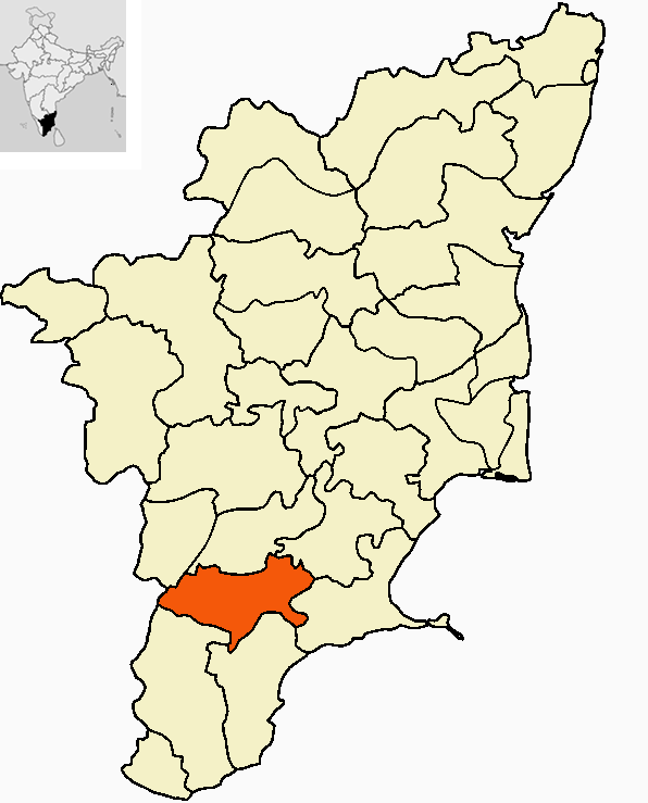
The district is bounded by Sivagangai district and Madurai district on the north, Tirunelveli district and Tuticorin District to the south and Ramanathapuram District on east and Kerala state to the west and Theni district to the northwest.
Administration[]
The district is divided into 2 revenue divisions - Sivakasi and Aruppukottai.
The district comprises eight taluks: Aruppukkottai, Kariapatti, Rajapalayam, Sattur, Sivakasi, Srivilliputhur, Tiruchuli and Virudhunagar. Totally there are 600 revenue villages in this district.
This district has 9 Town Panchayats - Seithur, Vathirairuppu, Chettiarpatti, Kariapatti, Mamsapuram, Sundarapandiam, Mallankinaru, S.Kodikulam and V.Pudupatti
The Parliamentary Constituency number of Virudhunagar District is 34.
Places[]
Shenbagathoppu (Srivilliputtur) Grizzled Squirrel Sanctuary[]


Shenbagathoppu, with its calm and serene ambiance, is a favorite spot for tourists.
Shenbaga Thoppu, a forest area about 8 km west from Srivilliputtur is a very good option for trekking. There is no proper bus service to reach here though. However, the place can be reached by two-wheeler or even cycle. The forests are found on the eastern slopes of the Western Ghats. Only 6.3% of the total geographical area of Virudhunagar district is under forests.
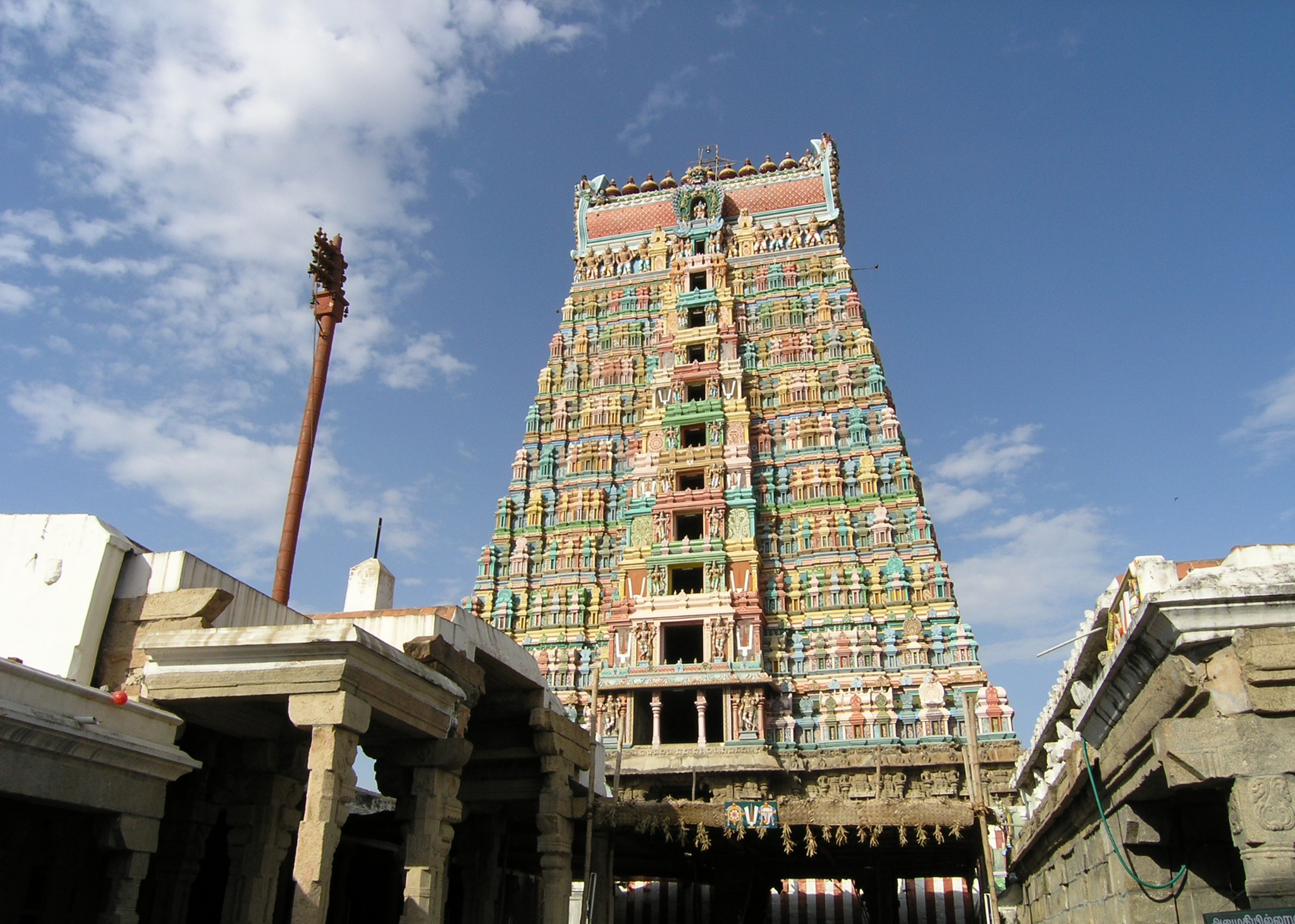
Srivilliputtur is very famous for Temples and Palkova.
Economy[]
Virudhunagar district is leading in the country in the match industry, fireworks and printing, mostly concentrated in and around Sivakasi. Virudhunagar is the main market for oil, chicory, coffee seeds, dry chillies and pulses. There are two trade centres (Godowns) in the District one in Virudhunagar and another in Rajapalayam. Ginning factories, spinning mills, power loom and hand loom industries are also present in the district at Rajapalayam the second big weaving town in the state after Coimbatore. One of the cement plants of Madras Cements Ltd is located in RR Nagar near Viudhunagar another one located at Alankulam of SIvakasi Taluk.
See also[]
- Villages in Virudhunagar district
References[]
- ^ www.tn.gov.in
- ^ a b c d e f "District Census 2011". Census2011.co.in. 2011. http://www.census2011.co.in/district.php. Retrieved 2011-09-30.
- ^ US Directorate of Intelligence. "Country Comparison:Population". https://www.cia.gov/library/publications/the-world-factbook/rankorder/2119rank.html. Retrieved 2011-10-01. "Lesotho1,924,886"
- ^ "2010 Resident Population Data". U. S. Census Bureau. http://2010.census.gov/2010census/data/apportionment-pop-text.php. Retrieved 2011-09-30. " West Virginia1,852,994"
- ^ census India
External links[]

|
Theni district | Madurai district | Sivaganga district |
|
| Idukki district, Kerala | Ramanathapuram district | |||
 Virudhunagar district | ||||
| Tirunelveli district | Thoothukudi district |
Template:Virudhunagar district
| ||||||||||||||||||||||||||||||||||||||||
| This page uses content from the English language Wikipedia. The original content was at Virudhunagar district. The list of authors can be seen in the page history. As with this Familypedia wiki, the content of Wikipedia is available under the Creative Commons License. |