m (AWB cleanup- template:wp) |
m (update from Wikipedia) |
||
| Line 4: | Line 4: | ||
| county = Utah County |
| county = Utah County |
||
| state = Utah |
| state = Utah |
||
| − | | seal |
+ | | seal = |
| − | | seallink |
+ | | seallink = |
| map size = 150 |
| map size = 150 |
||
| founded year = 1852 |
| founded year = 1852 |
||
| Line 17: | Line 17: | ||
| area_water_km2 = 369 |
| area_water_km2 = 369 |
||
| area percentage = 6.66% |
| area percentage = 6.66% |
||
| − | | |
+ | | pop = 530499 |
| + | | census estimate yr = 2011 |
||
| − | | pop = 368536 |
||
| + | | density_sq_mi = 258.5 |
||
| − | | density mi |
||
| + | | time zone = Mountain |
||
| − | | density km |
||
| − | | |
+ | | UTC offset = -7 |
| − | | |
+ | | DST offset = -6 |
| ⚫ | |||
| − | | DST offset |
||
| + | | web = www.utahcountyonline.org |
||
| ⚫ | |||
| ⚫ | |||
| − | | web = www.co.utah.ut.us |
||
| ⚫ | |||
}} |
}} |
||
| − | '''Utah County''' is a [[ |
+ | '''Utah County''' is a [[County (United States)|county]] in the US state of [[Utah]]. As of the [[2010 United States Census|2010 census]], the population was 516,564.<ref name="Census 2010">{{Cite web| url=http://factfinder2.census.gov| title=Profile of General Population and Housing Characteristics: 2010 Demographic Profile Data (DP-1): Utah County, Utah| publisher=U.S. Census Bureau, American Factfinder| accessdate=March 6, 2012}}</ref> It was named for the Spanish name (''Yuta'') for the [[Ute people|Ute]] [[Native Americans in the United States|Indians]]. The [[county seat]] and largest city is [[Provo, Utah|Provo]], which is the third-largest city in the state. The [[center of population]] of the state is located within this county, in the city of [[Lehi, Utah|Lehi]].<ref>[http://www.census.gov/geo/www/cenpop/statecenters.txt Population and Population Centers by State: 2000]</ref> Utah County is part of the [[Provo-Orem metropolitan area|Provo-Orem Metropolitan Statistical Area]]. |
| + | |||
| + | Utah County is one of seven counties in the United States to share the same name as their states (the other six counties are [[Arkansas County, Arkansas|Arkansas County]], [[Hawaii County, Hawaii|Hawaii County]], [[Idaho County, Idaho|Idaho County]], [[Iowa County, Iowa|Iowa County]], [[Manhattan|New York County]], and [[Oklahoma County, Oklahoma|Oklahoma County]]). |
||
==Geography== |
==Geography== |
||
| − | According to the [[United States Census Bureau|U.S. Census Bureau]], the county has a total area of |
+ | According to the [[United States Census Bureau|U.S. Census Bureau]], the county has a total area of {{convert|2141|sqmi|km2}}, of which {{convert|1998|sqmi|km2}} is land and {{convert|143|sqmi|km2}} (6.66%) is water. |
| ⚫ | [[Utah Valley]] lies at the center of the county, lined by the mountains of the [[Wasatch Range]] on the east. [[Utah Lake]] occupies a large part of the valley. The elevation ranges from {{convert|4487|ft}} above sea level at the lake to {{convert|11928|ft}} at the peak of [[Mount Nebo (Utah)|Mount Nebo]]. |
||
| + | |||
| ⚫ | |||
| ⚫ | |||
| ⚫ | |||
| ⚫ | |||
| ⚫ | |||
| ⚫ | |||
| ⚫ | |||
| ⚫ | |||
| + | |||
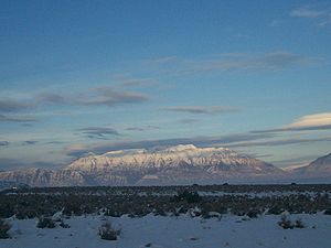
| + | [[Image:Baled hay in Utah Valley.jpg|250px|thumb|A partial view of [[Utah Valley]] seen here from outside of [[Salem, Utah|Salem]]]] |
||
| + | ===National protected areas=== |
||
| ⚫ | [[ |
||
| + | * [[Ashley National Forest]] (part) |
||
| + | * [[Manti-La Sal National Forest]] (part) |
||
| + | * [[Timpanogos Cave National Monument]] |
||
| + | * [[Uinta-Wasatch-Cache National Forest]] (part) |
||
| ⚫ | |||
| ⚫ | |||
| ⚫ | |||
| ⚫ | |||
| ⚫ | |||
| ⚫ | |||
| ⚫ | |||
| ⚫ | |||
==Government== |
==Government== |
||
| − | The government is an elected [[ |
+ | The government is an elected [[county commission]] made up of three [[commissioner]]s. Other elected officials include the county [[sheriff]], the [[county clerk]], and the [[county attorney]]. As of 2011, the three county commissioners are Gary Anderson, Doug Witney, and Larry Ellertson. Commissioner Ellertson's position will be up for election in 2012, with the other two seats decided in 2014. |
| ⚫ | |||
| ⚫ | |||
| + | Utah County's growth was recognized by the state legislature in 2011 by adding one new state Senate seat and two House district seats.<ref>{{cite web|last=Hesterman|first=Billy|title=Lawmakers say Utah County did well in redistricting process|url=http://www.heraldextra.com/news/local/govt-and-politics/legislature/article_f8184661-d34c-5959-bcf8-280bb2fedf5c.html|work=Daily Herald|accessdate=October 19, 2011}}</ref> |
||
| ⚫ | |||
| + | Utah County saw 43 of the state's 100 cases of [[West Nile virus]] in 2006. Following two deaths from the disease and requests from residents, the Utah County Health Department hired additional staff for their [[mosquito]] abatement program. Despite their efforts, 20% of the mosquito species that carry the virus in the county are infected.<ref>{{cite news|last=Page|first=Jared|title=Utah County to hire skeeter fighter|url=http://www.deseretnews.com/article/1,5143,645201051,00.html|accessdate=July 22, 2010|newspaper=Deseret News|date=September 13, 2006}}</ref> |
||
| ⚫ | As of the |
||
| ⚫ | |||
| ⚫ | |||
| − | * [[Wikipedia:Danish people|Danish]]-7% |
||
| ⚫ | |||
| − | * [[Wikipedia:Scottish people|Scottish]]-4% |
||
| + | ==Infrastructure== |
||
| − | By 2005 non-Hispanic whites were 87.7% of the county population. 0.4% of the population was African-American. The Native American population was holding steady at 0.6%, but it should be remembered with the county population growing quite fast, this meant the number of Native Americans was on the rise. Pacific Islanders were still 0.6% of the population. Latinos were now 8.4% of the population.<ref>[http://quickfacts.census.gov/qfd/states/49/49049.html U.S.Census Bureau, State & County QuickFacts, Utah County, Utah]</ref> |
||
| + | ===I-15 CORE=== |
||
| ⚫ | |||
| + | The I-15 CORE project is an expansion project that is adding multiple lanes on [[Interstate 15]] through all of Utah County. This expands {{convert|24|mi}} of freeway and is scheduled for completion in December 2012, but with a major protion by June 2012.<ref>{{cite web|title=New changes on I-15 in Utah County|url=http://www.deseretnews.com/article/705393062/New-changes-on-I-15-in-Utah-County.html|accessdate=October 28, 2011}}</ref> |
||
| ⚫ | |||
| ⚫ | In the county, the population was spread out with |
||
| ⚫ | Utah County has been referred to as "the most [[Republican Party (United States)|Republican]] county in the most Republican state in the United States."<ref>Krakauer, Jon. ''Under the Banner of Heaven''. Doubleday. New York, 2003. p.78.</ref> In the [[United States presidential election, 1992|1992 presidential election]], [[George H. W. Bush]] received the most votes and [[Bill Clinton]] was third in votes received. In the [[United States presidential election, 2004|2004 presidential election]], 85.99% voted for [[George W. Bush]].<ref>[http://www.co.utah.ut.us/Dept/ClerkAud/Elections/ElectRslts/2004_gen/index.htm#1 Utah County General Election, Official Results, November 2, 2004]</ref> In the [[United States presidential election, 2008|2008 U.S. presidential election]], the county voted for [[John McCain]] by a 58.9% margin over [[Barack Obama]], with McCain winning by 28.1% statewide.<ref>[http://www.uselectionatlas.org/RESULTS/ U.S. Election Atlas]</ref> Eight other Utah counties voted more strongly in favor of McCain.<ref>[http://www-cdn.npr.org/news/specials/election2008/presCounty.php?state=Utah State of Utah County Election Results, November 21, 2008]</ref> |
||
| ⚫ | |||
| ⚫ | |||
| + | {{US Census population |
||
| + | |1850= 2026 |
||
| + | |1860= 8248 |
||
| + | |1870= 12203 |
||
| + | |1880= 17973 |
||
| + | |1890= 23768 |
||
| + | |1900= 32456 |
||
| + | |1910= 37942 |
||
| + | |1920= 40792 |
||
| + | |1930= 49021 |
||
| + | |1940= 57382 |
||
| + | |1950= 81912 |
||
| + | |1960= 106991 |
||
| + | |1970= 137776 |
||
| + | |1980= 218106 |
||
| + | |1990= 263590 |
||
| + | |2000= 368540 |
||
| + | |2010= 516564 |
||
| + | |estimate= 530499 |
||
| + | |estyear= 2011 |
||
| + | |footnote=<center>[http://www.census.gov/prod/www/abs/decennial/ U.S. Decennial Census]<br>[http://www.census.gov/popest/data/counties/totals/2011/tables/CO-EST2011-01-49.csv 2011 estimate]</center>ref> |
||
| + | |}} |
||
| ⚫ | As of the census of 2010, there were 516,564 people, 140,602 households, and 114,350 families residing in the county. The population density was 259 people per square mile (100/km²). There were 148,350 housing units, at an average density of 74 per square mile (29/km²). The racial makeup of the county was 89.4% [[Race (United States Census)|White]], 0.5% Black or African American, 0.6% American Indian or Alaska Native, 1.4% Asian, 0.8% Native Hawaiian or other Pacific Islander, 4.6% some other race, and 2.7% from two or more races. 10.8% of the population were Hispanic or Latino of any race.<ref name="Census 2010"/> |
||
| ⚫ | There were 140,602 households, out of which 47.7% had children under the age of 18 living with them, 69.9% were headed by married couples living together, 8.0% had a female householder with no husband present, and 18.7% were non-families. 11.6% of all households were made up of individuals, and 4.4% were someone living alone who was 65 years of age or older. The average household size was 3.57, and the average family size was 3.88.<ref name="Census 2010"/> |
||
| − | By 2006 the population had risen 26.1% to 464,760. |
||
| ⚫ | In the county, the population was spread out with 35.2% under the age of 18, 15.8% from 18 to 24, 28% from 25 to 44, 14.5% from 45 to 64, and 6.5% who were 65 years of age or older. The median age was 24.6 years. For every 100 females there were 100.3 males. For every 100 females age 18 and over, there were 97.7 males.<ref name="Census 2010"/> |
||
| − | ===Happy Valley=== |
||
| ⚫ | At the 2000 census, the median income for a household in the county was $45,833, and the median income for a family was $50,196. Males had a median income of $37,878 versus $22,656 for females. The per capita income for the county was $15,557. About 6.80% of families and 12.00% of the population were below the poverty line, including 8.40% of those under age 18 and 4.80% of those age 65 or over. |
||
| − | About 88% of Utah County residents are [[Wikipedia:Latter Day Saint|LDS]].<ref>[http://deseretnews.com/dn/view/0%2C1249%2C455030805%2C00.html]<!-- Outdated, broken link --></ref> "Happy Valley" is a common [[Wikipedia:nickname|nickname]] for the region. The term is sometimes used in a [[Wikipedia:pejorative|pejorative]] or [[Wikipedia:irony|ironic]] sense. |
||
| + | |||
| + | The top 5 reported ancestries<ref>These should not be described as ethnic groups, because the question was not about what ethnicity someone had but what ancestry they had. Only two ancestries were allowed to be reported, but unlike reports of race there is no distinction made between those who reported only one and those who reported multiple.</ref> in Utah County are:<ref>[http://www.epodunk.com/cgi-bin/genealogyInfo.php?locIndex=22854 Utah County, Utah, Ancestry & Family History]</ref> |
||
| + | * English-30% |
||
| ⚫ | |||
| ⚫ | |||
| ⚫ | |||
| + | * Scottish-4% |
||
| + | |||
| + | '''Religion'''<br /> |
||
| + | 88.1% Mormon<br /> |
||
| + | 10.1% Non Religious<br /> |
||
| + | 1.8% Other<br /><ref>[http://www.city-data.com/county/religion/Utah-County-UT.html Utah County Religion]</ref> |
||
| + | |||
| + | ==Schools== |
||
| + | Utah County has three school districts, [[Alpine School District|Alpine]], [[Provo School District|Provo]], and [[Nebo School District|Nebo]].<ref>http://www.schools.utah.gov/pr/edinfo/default.htm</ref> It also has two universities: [[Brigham Young University]] and [[Utah Valley University]]. |
||
==In popular culture== |
==In popular culture== |
||
| + | * The 2003 book ''[[Under the Banner of Heaven]]'' written by [[Jon Krakauer]] discusses locations throughout Utah County. |
||
| − | * The 2007 film [http://www.imdb.com/title/tt0790612/ American Fork] was filmed in that city. |
||
| + | * The 2007 film ''American Fork'' (later known as ''Humble Pie'') was filmed in [[American Fork, Utah|that city]].<ref>http://www.imdb.com/title/tt0790612/</ref> |
||
| − | * The film [[ |
+ | * The film ''[[Brigham City (film)|Brigham City]]'' was filmed in [[Mapleton, Utah|Mapleton]]. Despite the name of the film, [[Richard Dutcher]] had Mapleton, not [[Brigham City, Utah|Brigham City]], in mind in making the film. |
| + | * The 1984 film ''[[Footloose (1984 film)|Footloose]]'' was filmed at various locations in Utah County: American Fork, [[Lehi, Utah|Lehi]], [[Orem, Utah|Orem]], [[Payson, Utah|Payson]], and [[Provo, Utah|Provo]]. |
||
| + | * The 1985 film ''[[Fletch (film)|Fletch]]'' is set in part in Provo. The dialogue makes frequent reference to the city.<ref>[http://www.ldsfilm.com/movies/Fletch.html]</ref> |
||
| + | * The 2008 documentary ''Happy Valley'' is about drug abuse in Utah County.<ref>http://www.amazon.com/dp/B001CK7OOW</ref> |
||
| + | *The book ''Social Welfare: Politics and Public Policy'', by Diana DiNitto, mentions Utah County as one of the three most generous counties in philanthropic donations in the U.S., based on an article in ''Giving USA 2003'' (the other two were [[San Juan County, Utah]] and [[Madison County, Idaho]]).<ref>AAFRC Trust for Philanthropy, Giving USA 2003</ref> |
||
==Cities and towns== |
==Cities and towns== |
||
| − | [[Image:Phone 006.jpg|right|300px|thumb|Utah Valley, Utah County as seen from Traverse Ridge in Lehi |
+ | [[Image:Phone 006.jpg|right|300px|thumb|Utah Valley, Utah County as seen from Traverse Ridge in Lehi]] |
| − | [[ |
+ | [[File:Mt. Timpanogos (2007).jpg|right|300px|thumb|Mount Timpanogos in the Wasatch Range is visible from much of Utah County.]] |
| − | *[[ |
+ | *[[Alpine, Utah|Alpine]], incorporated in 1855 |
| − | *[[ |
+ | *[[American Fork, Utah|American Fork]], incorporated in 1853 |
| − | *[[ |
+ | *[[Cedar Fort, Utah|Cedar Fort]], incorporated in 1965 |
| − | *[[ |
+ | *[[Cedar Hills, Utah|Cedar Hills]], incorporated in 1976 |
| − | *[[ |
+ | *[[Draper, Utah|Draper]], incorporated in 1978 and annexed land in Utah County in 2004 |
| − | *[[ |
+ | *[[Eagle Mountain, Utah|Eagle Mountain]], incorporated in 1996 |
| − | *[[ |
+ | *[[Elk Ridge, Utah|Elk Ridge]], incorporated in 1976 |
| − | *[[ |
+ | *[[Fairfield, Utah|Fairfield]], incorporated in 2004 |
| − | *[[ |
+ | *[[Genola, Utah|Genola]], incorporated in 1935 |
| − | *[[ |
+ | *[[Goshen, Utah|Goshen]], incorporated in 1910 |
| − | *[[ |
+ | *[[Highland, Utah|Highland]], incorporated in 1977 |
| − | *[[ |
+ | *[[Lehi, Utah|Lehi]], incorporated in 1852 |
| − | *[[ |
+ | *[[Lindon, Utah|Lindon]], incorporated in 1924 |
| − | *[[ |
+ | *[[Mapleton, Utah|Mapleton]], incorporated in 1948 |
| − | *[[ |
+ | *[[Orem, Utah|Orem]], incorporated in 1919 |
| − | *[[ |
+ | *[[Payson, Utah|Payson]], incorporated in 1853 |
| − | *[[ |
+ | *[[Pleasant Grove, Utah|Pleasant Grove]], incorporated in 1855 |
| − | *[[ |
+ | *[[Provo, Utah|Provo]], incorporated in 1849 |
| − | *[[ |
+ | *[[Salem, Utah|Salem]], incorporated in 1920 |
| − | *[[ |
+ | *[[Santaquin, Utah|Santaquin]], incorporated in 1932 |
| − | *[[ |
+ | *[[Saratoga Springs, Utah|Saratoga Springs]], incorporated in 1997 |
| − | *[[ |
+ | *[[Spanish Fork, Utah|Spanish Fork]], incorporated in 1855 |
| − | *[[ |
+ | *[[Springville, Utah|Springville]], incorporated in 1853 |
| − | *[[ |
+ | *[[Vineyard, Utah|Vineyard]], incorporated in 1989 |
| − | *[[ |
+ | *[[Woodland Hills, Utah|Woodland Hills]] |
| + | ===Census-designated places=== |
||
| ⚫ | |||
| − | *[[ |
+ | * [[Benjamin, Utah|Benjamin]] |
| − | *[[ |
+ | * [[Elberta, Utah|Elberta]] |
| − | *[[ |
+ | * [[Lake Shore, Utah|Lake Shore]] |
| − | *[[ |
+ | * [[Palmyra, Utah|Palmyra]] |
| − | *[[ |
+ | * [[Spring Lake, Utah|Spring Lake]] |
| ⚫ | |||
| − | *[[Wikipedia:Thistle, Utah|Thistle]] ([[Wikipedia:ghost town|ghost town]]) |
||
| ⚫ | |||
| ⚫ | |||
| ⚫ | |||
| + | * [[Vivian Park, Utah|Vivian Park]] |
||
| ⚫ | |||
| + | |||
| − | *[http://www.SugarHouseTrolley Utah County Trolley] An alternative to TRAX (in the preliminary stages). |
||
| + | ==See also== |
||
| − | *[http://www.utah-county-jail.com Utah County Jail] Information about the Utah County Jail. |
||
| + | *[[National Register of Historic Places listings in Utah County, Utah]] |
||
== References == |
== References == |
||
| + | {{cleanup-link rot|date=October 2011}} |
||
| − | {{reflist}} |
+ | {{reflist|2}} |
| + | |||
| ⚫ | |||
| + | {{commons category}} |
||
| + | *[http://www.utahcountyonline.org/ Utah County official website] |
||
| ⚫ | |||
| + | |||
| + | {{Geographic Location |
||
| + | |Centre = Utah County, Utah |
||
| + | |North = [[Salt Lake County, Utah|Salt Lake County]] |
||
| + | |Northeast = [[Wasatch County, Utah|Wasatch County]] |
||
| + | |East = [[Duchesne County, Utah|Duchesne County]] |
||
| + | |Southeast = [[Carbon County, Utah|Carbon County]] |
||
| + | |South = [[Sanpete County, Utah|Sanpete County]] |
||
| + | |Southwest = [[Juab County, Utah|Juab County]] |
||
| + | |West = [[Tooele County, Utah|Tooele County]] |
||
| + | |Northwest = |
||
| + | }} |
||
| + | {{Utah County, Utah}} |
||
{{Utah}} |
{{Utah}} |
||
| − | {{ |
+ | {{Coord|40.12|-111.67|display=title|type:adm2nd_region:US-UT_source:UScensus1990}} |
[[Category:Counties of Utah]] |
[[Category:Counties of Utah]] |
||
[[Category:Utah County, Utah| ]] |
[[Category:Utah County, Utah| ]] |
||
| + | [[Category:Established in 1852]] |
||
| − | <noinclude><small>{{usedwp|Utah County, Utah}}</small></noinclude> |
||
| + | [[Category:Provo–Orem metropolitan area]] |
||
| + | |||
| + | {{usedwp}} |
||
Revision as of 06:42, 12 September 2012
| ||||||||||||||
| Utah County, Utah | |
 Location in the state of Utah | |
 Utah's location in the U.S. | |
| Founded | 1852 |
|---|---|
| Named for | The Ute Native Americans |
| Seat | Provo |
| Largest city | Provo |
| Area - Total - Land - Water |
2,141 sq mi (5,545 km²) 1,998 sq mi (5,176 km²) 143 sq mi (369 km²), 6.66% |
| PopulationEst. - (2011) - Density |
530,499 258.5/sq mi (100/km²) |
| Time zone | Mountain: UTC-7/-6 |
| Website | www.utahcountyonline.org |
Utah County is a county in the US state of Utah. As of the 2010 census, the population was 516,564.[1] It was named for the Spanish name (Yuta) for the Ute Indians. The county seat and largest city is Provo, which is the third-largest city in the state. The center of population of the state is located within this county, in the city of Lehi.[2] Utah County is part of the Provo-Orem Metropolitan Statistical Area.
Utah County is one of seven counties in the United States to share the same name as their states (the other six counties are Arkansas County, Hawaii County, Idaho County, Iowa County, New York County, and Oklahoma County).
Geography
According to the U.S. Census Bureau, the county has a total area of 2,141 square miles (5,550 km2), of which 1,998 square miles (5,170 km2) is land and 143 square miles (370 km2) (6.66%) is water. Utah Valley lies at the center of the county, lined by the mountains of the Wasatch Range on the east. Utah Lake occupies a large part of the valley. The elevation ranges from 4,487 feet (1,368 m) above sea level at the lake to 11,928 feet (3,636 m) at the peak of Mount Nebo.
Adjacent counties
- Salt Lake – (north)
- Tooele – (west)
- Wasatch – (east)
- Juab – (south and west)
- Sanpete – (south central)
- Carbon – (south on east)
- Duchesne – (southeast)

A partial view of Utah Valley seen here from outside of Salem
National protected areas
- Ashley National Forest (part)
- Manti-La Sal National Forest (part)
- Timpanogos Cave National Monument
- Uinta-Wasatch-Cache National Forest (part)
Government
The government is an elected county commission made up of three commissioners. Other elected officials include the county sheriff, the county clerk, and the county attorney. As of 2011, the three county commissioners are Gary Anderson, Doug Witney, and Larry Ellertson. Commissioner Ellertson's position will be up for election in 2012, with the other two seats decided in 2014.
Utah County's growth was recognized by the state legislature in 2011 by adding one new state Senate seat and two House district seats.[3]
Utah County saw 43 of the state's 100 cases of West Nile virus in 2006. Following two deaths from the disease and requests from residents, the Utah County Health Department hired additional staff for their mosquito abatement program. Despite their efforts, 20% of the mosquito species that carry the virus in the county are infected.[4]
Infrastructure
I-15 CORE
The I-15 CORE project is an expansion project that is adding multiple lanes on Interstate 15 through all of Utah County. This expands 24 miles (39 km) of freeway and is scheduled for completion in December 2012, but with a major protion by June 2012.[5]
Politics
Utah County has been referred to as "the most Republican county in the most Republican state in the United States."[6] In the 1992 presidential election, George H. W. Bush received the most votes and Bill Clinton was third in votes received. In the 2004 presidential election, 85.99% voted for George W. Bush.[7] In the 2008 U.S. presidential election, the county voted for John McCain by a 58.9% margin over Barack Obama, with McCain winning by 28.1% statewide.[8] Eight other Utah counties voted more strongly in favor of McCain.[9]
Demographics
| Historical populations | |||
|---|---|---|---|
| Census | Pop. | %± | |
| 1850 | 2,026 | ||
| 1860 | 8,248 | 307.1% | |
| 1870 | 12,203 | 48.0% | |
| 1880 | 17,973 | 47.3% | |
| 1890 | 23,768 | 32.2% | |
| 1900 | 32,456 | 36.6% | |
| 1910 | 37,942 | 16.9% | |
| 1920 | 40,792 | 7.5% | |
| 1930 | 49,021 | 20.2% | |
| 1940 | 57,382 | 17.1% | |
| 1950 | 81,912 | 42.7% | |
| 1960 | 106,991 | 30.6% | |
| 1970 | 137,776 | 28.8% | |
| 1980 | 218,106 | 58.3% | |
| 1990 | 263,590 | 20.9% | |
| 2000 | 368,540 | 39.8% | |
| 2010 | 516,564 | 40.2% | |
| Est. 2011 | 530,499 | 43.9% | |
2011 estimate | |||
As of the census of 2010, there were 516,564 people, 140,602 households, and 114,350 families residing in the county. The population density was 259 people per square mile (100/km²). There were 148,350 housing units, at an average density of 74 per square mile (29/km²). The racial makeup of the county was 89.4% White, 0.5% Black or African American, 0.6% American Indian or Alaska Native, 1.4% Asian, 0.8% Native Hawaiian or other Pacific Islander, 4.6% some other race, and 2.7% from two or more races. 10.8% of the population were Hispanic or Latino of any race.[1]
There were 140,602 households, out of which 47.7% had children under the age of 18 living with them, 69.9% were headed by married couples living together, 8.0% had a female householder with no husband present, and 18.7% were non-families. 11.6% of all households were made up of individuals, and 4.4% were someone living alone who was 65 years of age or older. The average household size was 3.57, and the average family size was 3.88.[1]
In the county, the population was spread out with 35.2% under the age of 18, 15.8% from 18 to 24, 28% from 25 to 44, 14.5% from 45 to 64, and 6.5% who were 65 years of age or older. The median age was 24.6 years. For every 100 females there were 100.3 males. For every 100 females age 18 and over, there were 97.7 males.[1]
At the 2000 census, the median income for a household in the county was $45,833, and the median income for a family was $50,196. Males had a median income of $37,878 versus $22,656 for females. The per capita income for the county was $15,557. About 6.80% of families and 12.00% of the population were below the poverty line, including 8.40% of those under age 18 and 4.80% of those age 65 or over.
The top 5 reported ancestries[10] in Utah County are:[11]
- English-30%
- German-10%
- Danish-7%
- Mexican-5%
- Scottish-4%
Religion
88.1% Mormon
10.1% Non Religious
1.8% Other
[12]
Schools
Utah County has three school districts, Alpine, Provo, and Nebo.[13] It also has two universities: Brigham Young University and Utah Valley University.
In popular culture
- The 2003 book Under the Banner of Heaven written by Jon Krakauer discusses locations throughout Utah County.
- The 2007 film American Fork (later known as Humble Pie) was filmed in that city.[14]
- The film Brigham City was filmed in Mapleton. Despite the name of the film, Richard Dutcher had Mapleton, not Brigham City, in mind in making the film.
- The 1984 film Footloose was filmed at various locations in Utah County: American Fork, Lehi, Orem, Payson, and Provo.
- The 1985 film Fletch is set in part in Provo. The dialogue makes frequent reference to the city.[15]
- The 2008 documentary Happy Valley is about drug abuse in Utah County.[16]
- The book Social Welfare: Politics and Public Policy, by Diana DiNitto, mentions Utah County as one of the three most generous counties in philanthropic donations in the U.S., based on an article in Giving USA 2003 (the other two were San Juan County, Utah and Madison County, Idaho).[17]
Cities and towns

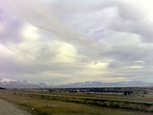
Utah Valley, Utah County as seen from Traverse Ridge in Lehi
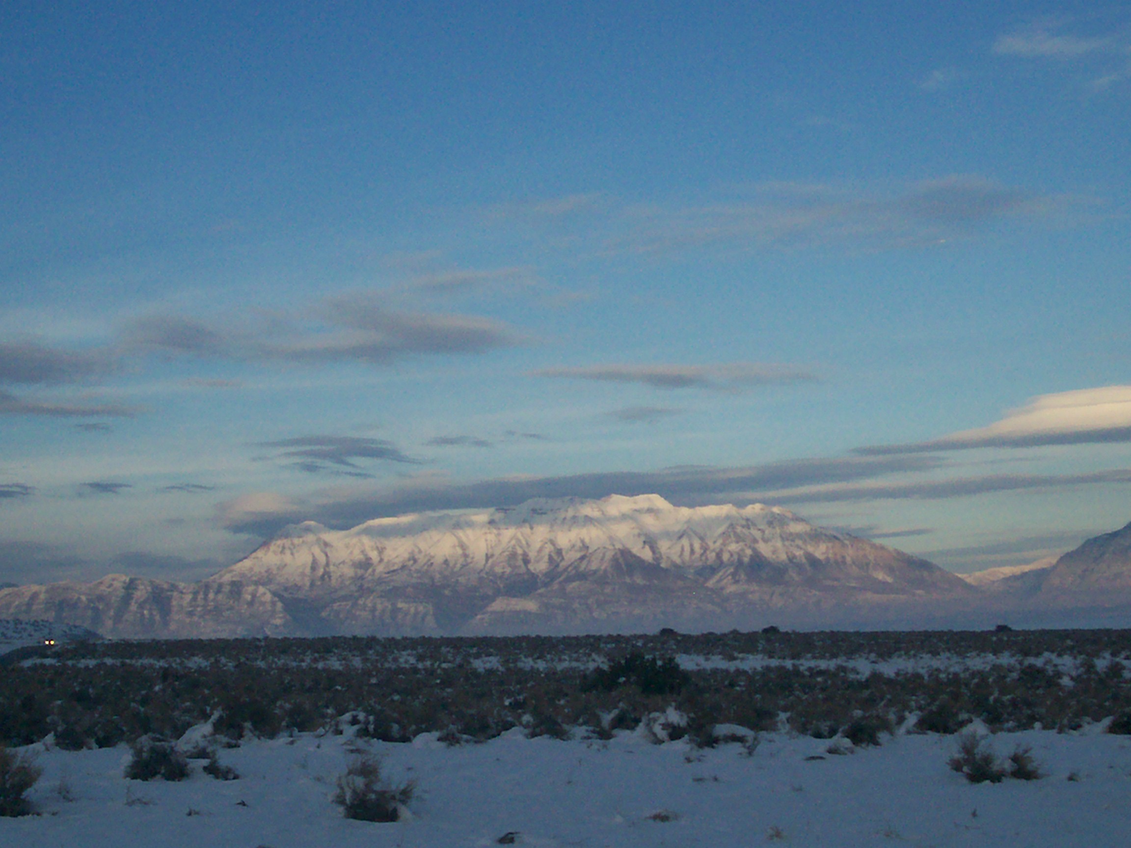
Mount Timpanogos in the Wasatch Range is visible from much of Utah County.
- Alpine, incorporated in 1855
- American Fork, incorporated in 1853
- Cedar Fort, incorporated in 1965
- Cedar Hills, incorporated in 1976
- Draper, incorporated in 1978 and annexed land in Utah County in 2004
- Eagle Mountain, incorporated in 1996
- Elk Ridge, incorporated in 1976
- Fairfield, incorporated in 2004
- Genola, incorporated in 1935
- Goshen, incorporated in 1910
- Highland, incorporated in 1977
- Lehi, incorporated in 1852
- Lindon, incorporated in 1924
- Mapleton, incorporated in 1948
- Orem, incorporated in 1919
- Payson, incorporated in 1853
- Pleasant Grove, incorporated in 1855
- Provo, incorporated in 1849
- Salem, incorporated in 1920
- Santaquin, incorporated in 1932
- Saratoga Springs, incorporated in 1997
- Spanish Fork, incorporated in 1855
- Springville, incorporated in 1853
- Vineyard, incorporated in 1989
- Woodland Hills
Census-designated places
- Benjamin
- Elberta
- Lake Shore
- Palmyra
- Spring Lake
- West Mountain
Unincorporated communities
- Vivian Park
See also
- National Register of Historic Places listings in Utah County, Utah
References
- ^ a b c d "Profile of General Population and Housing Characteristics: 2010 Demographic Profile Data (DP-1): Utah County, Utah". U.S. Census Bureau, American Factfinder. http://factfinder2.census.gov. Retrieved March 6, 2012.
- ^ Population and Population Centers by State: 2000
- ^ Hesterman, Billy. "Lawmakers say Utah County did well in redistricting process". Daily Herald. http://www.heraldextra.com/news/local/govt-and-politics/legislature/article_f8184661-d34c-5959-bcf8-280bb2fedf5c.html. Retrieved October 19, 2011.
- ^ Page, Jared (September 13, 2006). "Utah County to hire skeeter fighter". Deseret News. http://www.deseretnews.com/article/1,5143,645201051,00.html. Retrieved July 22, 2010.
- ^ "New changes on I-15 in Utah County". http://www.deseretnews.com/article/705393062/New-changes-on-I-15-in-Utah-County.html. Retrieved October 28, 2011.
- ^ Krakauer, Jon. Under the Banner of Heaven. Doubleday. New York, 2003. p.78.
- ^ Utah County General Election, Official Results, November 2, 2004
- ^ U.S. Election Atlas
- ^ State of Utah County Election Results, November 21, 2008
- ^ These should not be described as ethnic groups, because the question was not about what ethnicity someone had but what ancestry they had. Only two ancestries were allowed to be reported, but unlike reports of race there is no distinction made between those who reported only one and those who reported multiple.
- ^ Utah County, Utah, Ancestry & Family History
- ^ Utah County Religion
- ^ http://www.schools.utah.gov/pr/edinfo/default.htm
- ^ http://www.imdb.com/title/tt0790612/
- ^ [1]
- ^ http://www.amazon.com/dp/B001CK7OOW
- ^ AAFRC Trust for Philanthropy, Giving USA 2003
External links

|
Salt Lake County | Wasatch County |
| |
| Tooele County | Duchesne County | |||
 Utah County, Utah | ||||
| Juab County | Sanpete County | Carbon County |
| ||||||||||||||||||||||||||

.jpg)
| |||||||||||||||||||||||
| This page uses content from the English language Wikipedia. The original content was at Utah County, Utah. The list of authors can be seen in the page history. As with this Familypedia wiki, the content of Wikipedia is available under the Creative Commons License. |