| Main | Births etc |
|---|
| City of University City | |
|---|---|
| — City — | |
 |
|
 |
|
| Coordinates: | |
| Country | United States of America |
| State | Missouri |
| County | St. Louis |
| Area[1] | |
| • Total | 5.90 sq mi (15.28 km2) |
| • Land | 5.90 sq mi (15.28 km2) |
| • Water | 0 sq mi (0 km2) |
| Elevation | 528 ft (161 m) |
| Population (2010)[2] | |
| • Total | 35,371 |
| • Estimate (2012[3]) | 35,228 |
| • Density | 5,995.1/sq mi (2,314.7/km2) |
| Time zone | Central (CST) (UTC-6) |
| • Summer (DST) | CDT (UTC-5) |
| FIPS code | 29-75220[4] |
| GNIS feature ID | 0756828[5] |
University City (colloquially, U. City) is an inner-ring suburb of the city of St. Louis in St. Louis County, in the U.S. state of Missouri. The population was 35,371 in 2010 census.
The city is one of the older suburbs in the St. Louis area, having been a streetcar suburb in the late nineteenth and early twentieth centuries; much historic architecture remains in the southern, older portion of the city, particularly along Delmar Boulevard. The northern portions of the city, mostly developed after World War II, have more of a suburban feel with many shopping centers and other automobile-centered development.
University City has much municipal open space, dominated by 85-acre (344,000 m2) Heman Park (which includes recreation and community centers and public pool facilities) and Ruth Park (a public golf course and nature trails). The city has four elementary schools, one middle school and one high school. The University City school district is separately managed from other school districts in the area.
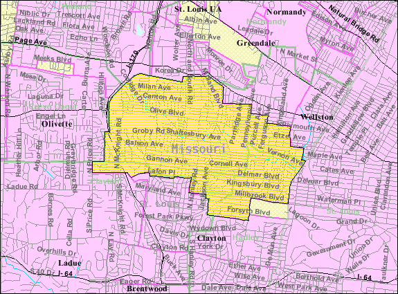
Geography[]
University City's southern border is approximated by Northmoor. The eastern border is approximated by Skinker Boulevard. The western border is approximated by old McKnight (some of which is now Interstate 170).
According to the United States Census Bureau, the city has a total area of 5.90 square miles (15.28 km2), all of it land.[1]
The Delmar Loop, an entertainment, cultural and restaurant district, is located along Delmar Boulevard, parallel with and six blocks north of the northern boundary of the university. The city is also home to the University City Olive Link, known for its high concentration of East Asian businesses and considered as a replacement for Chinatown, St. Louis. The highest point of University City is the Western terminus of Delmar Boulevard, at the tri-border of University City, Ladue, and Olivette.
The city also contains part of Midland Boulevard, which divides the watersheds of the Mississippi River and the Missouri River. Headwaters of the River Des Peres start in the hills near the University City and Clayton boundary, which flows north, takes a strong turn at Ruth Park, then is controlled through underground tunnels as it passes through the city of St. Louis.
Highways[]
Major roads and highways in University City are I-170, MO-340, Delmar Blvd, Forest Park Pkwy, and Skinker Pkwy.
Demographics[]
| Historical populations | |||
|---|---|---|---|
| Census | Pop. | %± | |
| 1910 | 2,417 | ||
| 1920 | 6,792 | 181.0% | |
| 1930 | 25,809 | 280.0% | |
| 1940 | 33,023 | 28.0% | |
| 1950 | 39,892 | 20.8% | |
| 1960 | 51,249 | 28.5% | |
| 1970 | 47,527 | −7.3% | |
| 1980 | 42,690 | −10.2% | |
| 1990 | 40,087 | −6.1% | |
| 2000 | 37,428 | −6.6% | |
| 2010 | 35,371 | −5.5% | |
| Est. 2012 | 35,228 | −5.9% | |
The city has long had a large middle-class Jewish presence. Jewish cemeteries and religious centers dot the city, such as Young Israel of St. Louis and Agudas Israel of St. Louis, serving University City residents and those of nearby Clayton, which also has a high concentration of Jewish residents.
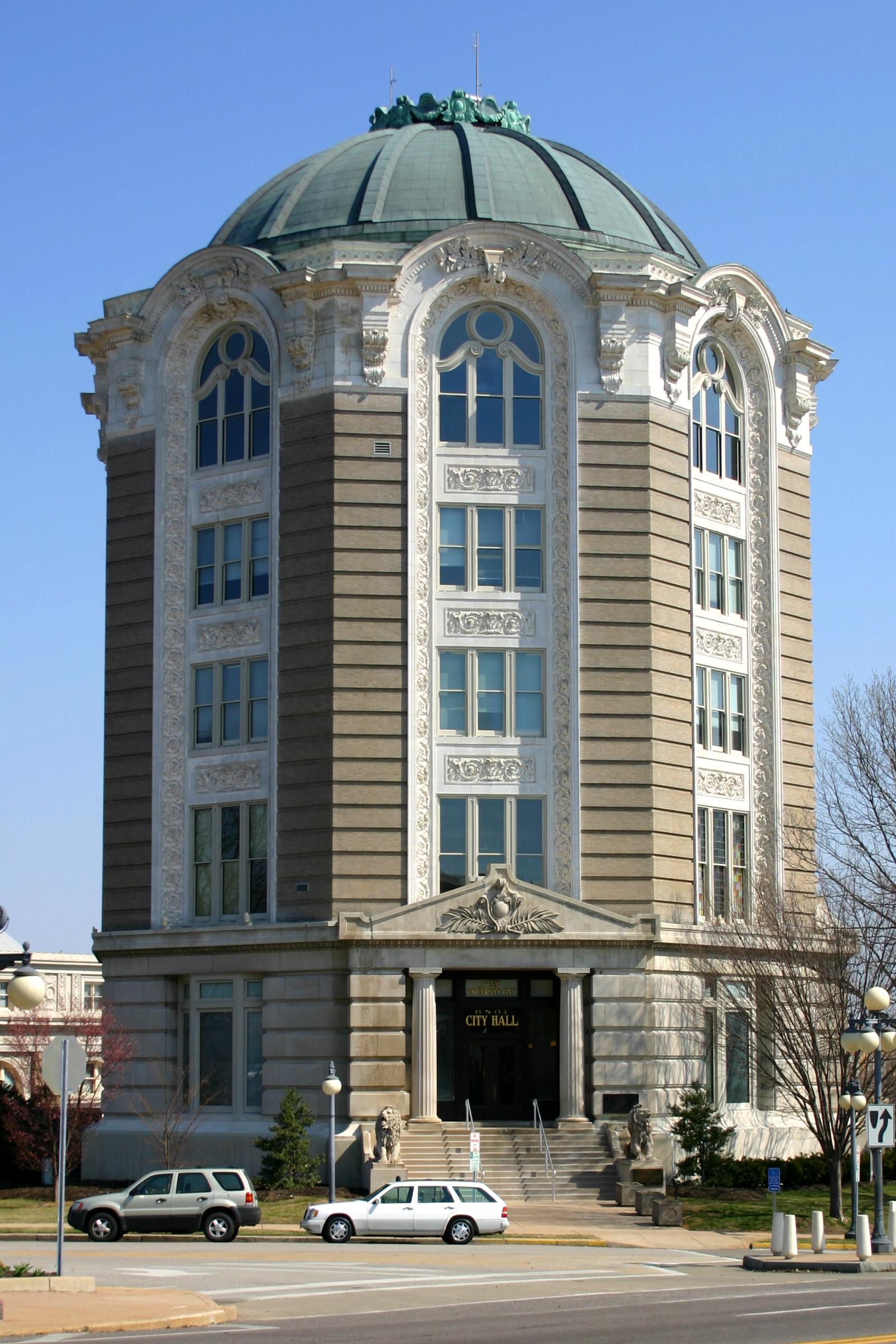
The University City City Hall building
2010 census[]
As of the census[2] of 2010, there were 35,371 people, 16,154 households, and 8,484 families residing in the city. The population density was 5,995.1 inhabitants per square mile (2,314.7 /km2). There were 18,021 housing units at an average density of 3,054.4 per square mile (1,179.3 /km2). The racial makeup of the city was 50.8% White, 41.1% African American, 0.3% Native American, 4.3% Asian, 0.9% from other races, and 2.7% from two or more races. Hispanic or Latino of any race were 2.8% of the population.
There were 16,154 households of which 23.8% had children under the age of 18 living with them, 33.8% were married couples living together, 15.0% had a female householder with no husband present, 3.7% had a male householder with no wife present, and 47.5% were non-families. 36.5% of all households were made up of individuals and 12.7% had someone living alone who was 65 years of age or older. The average household size was 2.18 and the average family size was 2.90.
The median age in the city was 37.4 years. 19.5% of residents were under the age of 18; 11.3% were between the ages of 18 and 24; 28.5% were from 25 to 44; 24.7% were from 45 to 64; and 16% were 65 years of age or older. The gender makeup of the city was 46.6% male and 53.4% female.
2000 census[]
As of the census[4] of 2000, there were 37,428 people, 16,453 households, and 9,114 families residing in the city. The population density was 6,363.1 people per square mile (2,457.7/km²). There were 17,485 housing units at an average density of 2,972.6 per square mile (1,148.1/km²). The racial makeup of the city was 49.26% White, 45.35% African American, 0.16% Native American, 2.85% Asian, 0.03% Pacific Islander, 0.56% from other races, and 1.80% from two or more races. Hispanic or Latino of any race were 1.56% of the population. The city is considered (by inhabitants) to be divided roughly into three zones from north to south. North of Olive is predominantly Black, from Olive to Delmar is mixed, and south of Delmar is predominantly White. Because of the city's racial composition, it has not been part of the integration busing program between the City of St. Louis and St. Louis County.
There were 16,453 households out of which 23.7% had children under the age of 18 living with them, 36.3% were married couples living together, 16.3% had a female householder with no husband present, and 44.6% were non-families. 34.2% of all households were made up of individuals and 10.2% had someone living alone who was 65 years of age or older. The average household size was 2.25 and the average family size was 2.96.
In the city the population was spread out with 21.8% under the age of 18, 11.3% from 18 to 24, 31.1% from 25 to 44, 22.4% from 45 to 64, and 13.3% who were 65 years of age or older. The median age was 35 years. For every 100 females there were 84.1 males. For every 100 females age 18 and over, there were 80.1 males.
The median income for a household in the city was $75,902, and the median income for a family was $52,539. Males had a median income of $55,588 versus $45,440 for females. The per capita income for the city was $26,901. About 9.5% of families and 14.7% of the population were below the poverty line, including 19.1% of those under age 18 and 12.1% of those age 65 or over.
History[]
University City was founded by publisher Edward Gardner Lewis, who began developing the location in 1903 around his publishing complex for Woman's Magazine and Woman's Farm Journal.[6] Historic buildings associated with municipal operations, including today's City Hall, were built by Lewis as facilities for his magazine enterprise. In 1906, the city incorporated and Lewis served as its first mayor.
Education[]
The School District of University City operates public schools.
University City has one high school: University City High School. The city also has one middle school, Brittany Woods Middle School, and four elementary schools: Flynn Park, Barbara C. Jordan, Pershing and Jackson Park.
The district web site is http://www.ucityschools.org/
Culture[]
University City is home to the COCA, a center for contemporary arts that has a nationally recognized pre-professional dance training program, with alumni dancing for Trisha Brown, Cecil Slaughter, Houston Ballet, Ballet Hispanico New York, Mark Morris, Alvin Ailey, the national tours of Wicked and Cinderella, and Tarzan on Broadway.[7]
University City has a public library, established in 1939, located at 6701 Delmar Boulevard. The library houses more than 150,000 volumes as well as music and spoken recordings, videotape and DVD collections, and numerous works of art. The library is open seven days a week, including five evenings.[8]
Politics[]
- Mayor: Shelley Welsch
- City Manager: Lehman Walker
- Boards and Commissions
- City Council:
In July 2009, a group of residents calling themselves "University City citizens for Transparency and Accountability" said they would begin collecting the 2,233 signatures necessary to have the State of Missouri audit the City's finances.[11] The City has been facing severe financial woes over the last few years and an attempt to balance the 2010 budget by creating a 0.25% sales tax was defeated by city voters on August 4, 2009.[12] On February 25, 2012, the International City/County Management Association (ICMA) censured University City's City Manager Lehman Walker and barred him from future membership. According to the ICMA, the "Board found that Mr. Walker violated Tenets 2, 3, and 4 of the ICMA Code of Ethics."[13]
Notable past and current residents[]
- Hallowell Davis (1896–1992), pioneer in studying the physiology of hearing, at the Central Institute for the Deaf [14]
- Stanley Elkin, novelist[15]
- Dave Garroway, host of many national TV shows in the '50's and '60' such as "The Today Show" and "Wide Wide World."
- Bernard Gilkey, New York Mets slugger
- Ken Hitchcock, head coach of the St. Louis Blues
- Ken Holtzman, Chicago Cubs pitcher who threw two no-hitters and won 174 games, the most by a Jewish pitcher
- Nelly, rapper
- Howard Nemerov, poet
- Robert Person, Mets pitcher
- Art Shamsky, Mets slugger
- Tennessee Williams, Pulitzer Prize-winning playwright
- Ike Willis, singer and sideman for Frank Zappa from 1978 to 1988
See also[]
- Delmar Loop Trolley
- Louisiana Purchase Exposition, also known as the 1904 World's Fair
- 1904 Summer Olympics, held a short distance from University City, on the Washington University Campus
References[]
- ^ a b "US Gazetteer files 2010". United States Census Bureau. http://www.census.gov/geo/www/gazetteer/files/Gaz_places_national.txt. Retrieved 2012-07-08.
- ^ a b "American FactFinder". United States Census Bureau. http://factfinder2.census.gov/faces/nav/jsf/pages/index.xhtml. Retrieved 2012-07-08.
- ^ "Population Estimates". United States Census Bureau. http://www.census.gov/popest/data/cities/totals/2012/SUB-EST2012.html. Retrieved 2013-05-30.
- ^ a b "American FactFinder". United States Census Bureau. http://factfinder2.census.gov. Retrieved 2008-01-31.
- ^ "US Board on Geographic Names". United States Geological Survey. 2007-10-25. http://geonames.usgs.gov. Retrieved 2008-01-31.
- ^ Edward Garden Lewis and University City http://history.ucpl.lib.mo.us/ Retrieved 2008-04-24
- ^ http://www.cocastl.org/subpage.cfm?vSection=about&vPage=alumni
- ^ http://www.ucpl.lib.mo.us/doc/libraryhistory.htm
- ^ "http://www.crowforucity.com/." Crow for University City. Retrieved on July 16, 2010.
- ^ http://universitycity.patch.com/articles/carr-crow-to-be-sworn-in-tonight
- ^ "Group says University City will be audited." KSDK. December, 2009. Retrieved July 16, 2010.
- ^ http://www.stltoday.com/stltoday/news/stories.nsf/stlouiscitycounty/story/EE30B24511B113D0862576020080EA31?OpenDocument
- ^ http://universitycity.patch.com/articles/icma-censures-bars-walker-for-ethics-violations
- ^ Saxon, Wolfgang. "Hallowell Davis, 96, an Explorer Who Charted the Inner Ear, Dies", The New York Times, September 10, 1992. Accessed July 15, 2010
- ^ "Widely acclaimed author, professor Stanley Elkin dies". Washington University in St. Louis. June 22, 1995. http://wupa.wustl.edu/record_archive/1995/06-22-95/7205.html. Retrieved December 23, 2012.
External links[]
| |||||||||||||||||||||||

| ||||||||||||||||||||||
| This page uses content from the English language Wikipedia. The original content was at University City, Missouri. The list of authors can be seen in the page history. As with this Familypedia wiki, the content of Wikipedia is available under the Creative Commons License. |