| Main | Births etc |
|---|
| Trois-Rivières | |||
|---|---|---|---|
| — City — | |||
| Ville de Trois-Rivières | |||
 |
|||
|
|||
| Motto: Deus nobiscum quis contra ("If God is with us, who can be against us") |
|||
 |
|||

Trois-Rivières |
|||
| Coordinates: Coordinates: [1] | |||
| Country | Canada | ||
| Province | Quebec | ||
| Region | Mauricie | ||
| RCM | None | ||
| Founded | July 4, 1634 by Laviolette | ||
| Incorporated | June 10, 1857 | ||
| Constituted | January 1, 2002 | ||
| Boroughs | Cap-de-la-Madeleine, Trois-Rivières-Ouest, Saint-Louis-de-France, Pointe-du-Lac, Sainte-Marthe-du-Cap |
||
| Government[2] | |||
| • Type | Trois-Rivières City Council | ||
| • Mayor | Yves Lévesque | ||
| • Federal riding | Berthier—Maskinongé and Trois-Rivières | ||
| • Prov. riding | Champlain and Maskinongé and Trois-Rivières | ||
| Area[2][3] | |||
| • City | 333.70 km2 (128.84 sq mi) | ||
| • Land | 288.90 km2 (111.54 sq mi) | ||
| • Urban[4] | 177.25 km2 (68.44 sq mi) | ||
| • Metro[5] | 1,041.15 km2 (401.99 sq mi) | ||
| Elevation | 61 m (200 ft) | ||
| Population [3] | |||
| • City | 137,026[6] | ||
| • Density | 1,581.2/km2 (4,095/sq mi) | ||
| • Urban[4] | 126,460 | ||
| • Urban density | 713.5/km2 (1,848/sq mi) | ||
| • Metro[5] | 151,773 | ||
| • Metro density | 145.8/km2 (378/sq mi) | ||
| • Pop 2006-2011 | |||
| • Dwellings | 65,528 | ||
| Demonym | Trifluvians | ||
| Time zone | EST (UTC−5) | ||
| • Summer (DST) | EDT (UTC−4) | ||
| Postal code(s) | G8T to G8Z, G9A to G9C | ||
| Area code | 819 | ||
| Website | v3r.net | ||

Trois-Rivières (French pronunciation: [tʁwɑ.ʁi.vjɛʁ], local pronunciation: [tʁwɔ.ʁi.vjaɛ̯ʁ](![]() listen)) is a city in the Mauricie administrative region of Quebec, Canada, at the confluence of the Saint-Maurice and Saint Lawrence rivers, on the north shore of the Saint Lawrence River across from the city of Bécancour. It is part of the densely populated Quebec City–Windsor Corridor and is approximately halfway between Montreal and Quebec City. Trois-Rivières is the economic and cultural hub of the Mauricie region.[7] The settlement was founded by French colonists on July 4, 1634, as the second permanent settlement in New France,[8] after Quebec City in 1608.
listen)) is a city in the Mauricie administrative region of Quebec, Canada, at the confluence of the Saint-Maurice and Saint Lawrence rivers, on the north shore of the Saint Lawrence River across from the city of Bécancour. It is part of the densely populated Quebec City–Windsor Corridor and is approximately halfway between Montreal and Quebec City. Trois-Rivières is the economic and cultural hub of the Mauricie region.[7] The settlement was founded by French colonists on July 4, 1634, as the second permanent settlement in New France,[8] after Quebec City in 1608.
The city's name, which is French for three rivers, is named for the fact the Saint-Maurice River has three mouths at the Saint Lawrence River; it is divided by two islands in the river. Historically, in the English language this city was known as Three Rivers. Since the late 20th century, when there has been more recognition of Quebec and French speakers, and French was made an official language, the city is generally referred to as Trois-Rivières in both English and French. The anglicized name still appears in many areas of the town (e.g., the city's Three Rivers Academy), bearing witness to the influence of English settlers in the town. The city's inhabitants are known as Trifluviens (Trifluvians).
Trois-Rivières is also the name of a territory equivalent to a regional county municipality (TE) of Quebec, coextensive with the city of Trois-Rivières. Its geographical code is 371. Together with the regional county municipality of Les Chenaux, it forms the census division (CD) of Francheville (37). The municipalities within Les Chenaux and the former municipalities that were amalgamated into Trois-Rivières formerly constituted the regional county municipality of Francheville. Trois-Rivières is the seat of the judicial district of the same name.[9] The Trois-Rivières metropolitan area also includes the city of Bécancour, which is situated on the south shore of the St. Lawrence River across the Laviolette Bridge.
Origin of name[]
The name of Trois-Rivières, which dates from the end of the 16th century, was used by French explorers in reference to the three channels in the Saint-Maurice River formed at its mouth with the Saint Lawrence, as it is divided by two islands, Potherie and Saint-Quentin island. The city occupies a location known to the French since 1535, when Jacques Cartier, in a trip along the St. Lawrence, stopped to plant a cross on Saint-Quentin island. But the Three Rivers name is used for the first time in 1599 by Sieur François Gravé Du Pont, a geographer under Champlain, whose records confirmed the name in 1603. As Sieur Gravé Du Pont sailed upriver toward Montreal, he saw what appeared to be three separate tributaries. He did not know two large islands divide the course of the Saint-Maurice River in three parts where the latter flows into the St. Lawrence River.
History[]
For thousands of years, the area that would later become known as Trois-Rivières was frequented by Indigenous peoples. The historic Algonquin and Abenaki peoples used it as a summer stopping place. They would fish and hunt here, as well as gather roots and nuts. The area was rich in resources. The French explorer Jacques Cartier described the site while on his second journey to the New World in 1535. The name "Trois-Rivières", however, was not given until 1599, by Captain Dupont-Gravé, and first appeared on maps of the area dated 1601.[10]
In 1603, while surveying the Saint-Lawrence River, Samuel de Champlain recommended establishing a permanent settlement in the area. Such a village was started on July 4, 1634, by the Sieur de Laviolette. Additional inhabitants of the early city of Trois-Rivières include: Quentin Moral, Sieur de St. Quentin; Pierre Boucher, Jacques Le Neuf, Jean Godefroy de Lintot, Michel Le Neuf du Hérisson, François Hertel, François Marguerie, René Robineau, and Jean Sauvaget.[11] The city was the second to be founded in New France (after Quebec City, before Montreal). Given its strategic location, it played an important role in the colony and in the fur trade with First Nations peoples. The settlement became the seat of a regional government in 1665. Ursuline nuns first arrived at the settlement in 1697, where they founded the first school and helped local missionaries to Christianize the local Aboriginals and developing class of Métis.
French sovereignty in Trois-Rivières continued until 1760, when the city was captured as part of the British conquest of Canada during the Seven Years' War. Sixteen years later, on June 8, 1776, it was the theatre of the Battle of Trois-Rivières (part of the ill-fated invasion of the province of Quebec by les Bostonnais, Americans from the Boston area) during the American Revolutionary War.
Trois-Rivières continued to grow in importance throughout this period and beyond. In 1792 it was designated as the seat of a judicial district. In 1852, the Roman Catholic church made this the see of the Diocese of Trois-Rivières.
In 1816, Captain A.G. Douglas, a former adjutant at the British military college at Great Marlow, recommended a military college for Catholic and Protestant boys be established at Trois-Rivières. He proposed it operate in a disused government house and he would be superintendent. Douglas' college was intended as a boarding school to educate the young sons of officers, amongst others, in Latin, English language, French Language, History, Geography, Drawing and Mathematics. This preceded the founding of the Royal Military College of Canada in 1876.[12]
In 1908, the greater part of the city of Trois-Rivières was destroyed by a fire; most of the city's original buildings, many dating to the French colonial years, were destroyed. Among the surviving buildings were the Ursuline Monastery and the De Tonnancour Manor. As a result of the destruction, a major redesign and renovation of the city was undertaken, including the widening and renewal of many of the city's roads. Many new businesses and industries became established in the town, attracting additional residents.
During the mid-century, the city became heavily industrialized and lost jobs during the later restructuring. In the 1960s, Trois-Rivières undertook a large-scale project of economic diversification, including founding several cultural institutions and attractions. The Old City of Trois-Rivières was declared an "historic sector" in 1964. The Laviolette Bridge, linking Trois-Rivières to Bécancour and the south shore of the Saint-Lawrence River, was opened officially on December 20, 1967. In 1969, the city founded the Université du Québec à Trois-Rivières, known for its chiropractic school, its podiatric medical education, and its programs for primary and secondary school education.
Although historically an important centre of commerce, trade and population, Trois-Rivières has been superseded by the two major cities of Quebec: the metropolis of Montreal and the capital of Quebec City. It remains as one of the principal medium-sized cities of Quebec, along with Saguenay, Sherbrooke, and Gatineau.
")
")
")
Cityscape[]
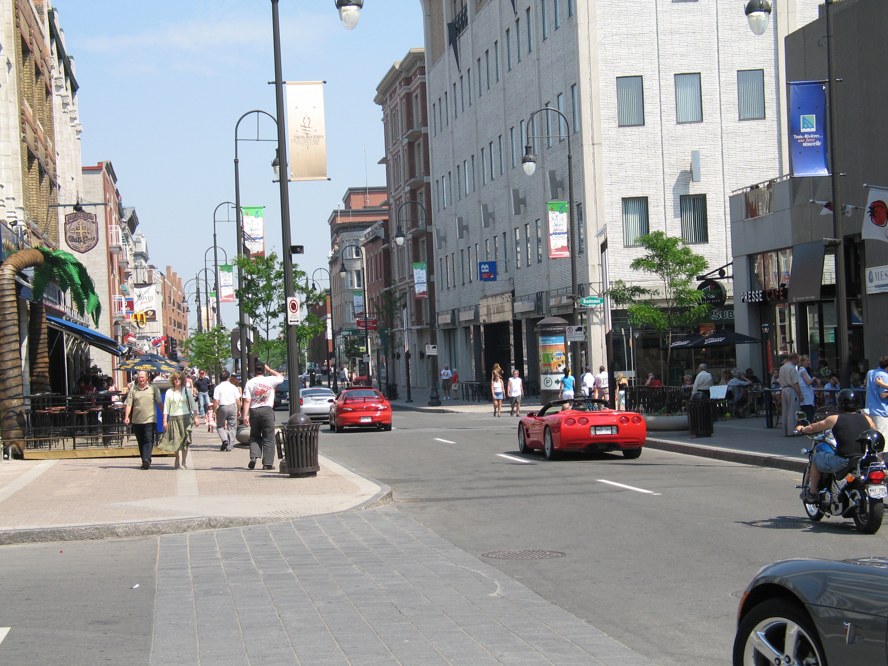
The city's main thoroughfare is Boulevard des Forges, an area several blocks long in the heart of the Old Town composed of century-old buildings housing a great variety of cafés, restaurants, clubs, bars, and shops. In the warmer months, the area is regularly closed to vehicular traffic to accommodate various festivals and events, turning the downtown core into a pedestrian mall.
Notable landmarks include the Forges du Saint-Maurice, a foundry dating back to the 1730s, the Ursulines Monastery, and Notre-Dame-du-Cap Basilica.
Economy[]


Trois-Rivières, 1760.
Trois-Rivières is Canada's oldest industrial city, with its first foundry established in 1738.[13] The forge produced iron and cast for 150 years, much of it being shipped to France to be used in French navy ships.[14] The first port facility was built in 1818 near rue Saint-Antoine, and today handles 2.5 million tonnes of cargo annually.[15] The first railway was built in 1879 to support the growing lumber industry.[16]
From the late 1920s until the early 1960s, the city was known as the pulp and paper industry capital of the world.[17] The city once had five mills in operation (Trois-Rivières Ouest, Wayagamack, C.I.P., and St-Maurice Paper). Today, there are three mills left operating (Kruger Trois-Rivières Ouest, Kruger Wayagamack and Cascades Lupel ex-St-Maurice Paper); the closures resulted largely to a decline in newsprint demand and globalization. The closures were not limited to just the pulp and paper industry. Trois-Rivières had an industrial decline in the 1980s and 1990s, when several textile mills were closed after owners moved jobs offshore. Unemployment rose to 14 percent in the 1990s.[18]
Trois-Rivières is attempting an industrial revitalization by establishing technology parks and taking advantage of its central location to both Montreal and Quebec City, its university and port. An example of the new economy is Marmen Incorporated, which manufactures wind turbine towers and employs 1,000 people between its operations in Trois-Rivières and Matane.
The city's other prominent industries include metal transformation, electronics, thermoplastics, and cabinet making. An industrial park adjoining Trois-Rivières Airport serves also as a major centre for the aeronautical industry. Also, the production of food crops is still important to the economy.
Climate[]
The area has a humid continental climate (Köppen Dfb). Winters are long, cold, and snowy: the January high is −7.1 °C (19.2 °F), with lows dropping to −20 °C (−4.0 °F) on 27 nights per year and to −30 °C (−22.0 °F) on 2.9 nights.[19] Snowfall averages 259 centimetres (102 in), with reliable snow cover from December to March.[19] Summers are warm, with an average July high of 25.5 °C (77.9 °F), and high temperatures reach 30 °C (86 °F) on 5.5 days per summer.[19] Spring and autumn are short and crisp. Precipitation averages 1,123 millimetres (44.2 in), and is the greatest during summer.
The highest temperature ever recorded in Trois-Rivières was 37.8 °C (100 °F) on 17 July 1953.[20] The coldest temperature ever recorded was −41.7 °C (−43 °F) on 5 February 1923.[21]
| Climate data for Trois-Rivières, 1981−2010 normals, extremes 1920−present[lower-alpha 1] | |||||||||||||
|---|---|---|---|---|---|---|---|---|---|---|---|---|---|
| Month | Jan | Feb | Mar | Apr | May | Jun | Jul | Aug | Sep | Oct | Nov | Dec | Year |
| Record high °C (°F) | 13.0 (55.4) |
11.1 (52.0) |
20.0 (68.0) |
31.5 (88.7) |
33.3 (91.9) |
34.5 (94.1) |
37.8 (100.0) |
36.1 (97.0) |
32.5 (90.5) |
28.9 (84.0) |
22.2 (72.0) |
14.6 (58.3) |
37.8 (100.0) |
| Average high °C (°F) | −7.1 (19.2) |
−4.4 (24.1) |
1.4 (34.5) |
9.9 (49.8) |
18.2 (64.8) |
23.3 (73.9) |
25.5 (77.9) |
24.4 (75.9) |
19.4 (66.9) |
11.9 (53.4) |
4.1 (39.4) |
−3.1 (26.4) |
10.3 (50.5) |
| Daily mean °C (°F) | −12.1 (10.2) |
−9.7 (14.5) |
−3.6 (25.5) |
4.8 (40.6) |
12.3 (54.1) |
17.6 (63.7) |
20.0 (68.0) |
18.9 (66.0) |
14.2 (57.6) |
7.4 (45.3) |
0.5 (32.9) |
−7.4 (18.7) |
5.2 (41.4) |
| Average low °C (°F) | −17.1 (1.2) |
−14.9 (5.2) |
−8.6 (16.5) |
−0.3 (31.5) |
6.3 (43.3) |
11.8 (53.2) |
14.4 (57.9) |
13.4 (56.1) |
8.9 (48.0) |
2.8 (37.0) |
−3.1 (26.4) |
−11.6 (11.1) |
0.2 (32.4) |
| Record low °C (°F) | −41.1 (−42.0) |
−41.7 (−43.1) |
−35 (−31.0) |
−20 (−4.0) |
−7.8 (18.0) |
−1.5 (29.3) |
3.5 (38.3) |
0.0 (32.0) |
−7.2 (19.0) |
−11.7 (10.9) |
−27.2 (−17.0) |
−35.6 (−32.1) |
−41.7 (−43.1) |
| Precipitation mm (inches) | 82.9 (3.264) |
68.8 (2.709) |
75.6 (2.976) |
79.2 (3.118) |
96.3 (3.791) |
107.0 (4.213) |
116.8 (4.598) |
101.3 (3.988) |
100.6 (3.961) |
98.4 (3.874) |
102.4 (4.031) |
93.4 (3.677) |
1,122.8 (44.205) |
| Rainfall mm (inches) | 24.5 (0.965) |
19.5 (0.768) |
32.0 (1.26) |
66.8 (2.63) |
96.3 (3.791) |
107.0 (4.213) |
116.8 (4.598) |
101.3 (3.988) |
100.6 (3.961) |
95.7 (3.768) |
75.4 (2.969) |
28.1 (1.106) |
863.9 (34.012) |
| Snowfall cm (inches) | 58.5 (23.03) |
49.3 (19.41) |
43.6 (17.17) |
12.5 (4.92) |
0.0 (0) |
0.0 (0) |
0.0 (0) |
0.0 (0) |
0.0 (0) |
2.8 (1.1) |
27.1 (10.67) |
65.3 (25.71) |
259.0 (101.97) |
| Avg. precipitation days (≥ 0.2 mm) | 13.9 | 11.9 | 11.1 | 11.9 | 14.4 | 14.4 | 15.0 | 12.8 | 12.8 | 14.3 | 14.4 | 14.2 | 161.1 |
| Avg. rainy days (≥ 0.2 mm) | 2.9 | 2.6 | 5.4 | 10.5 | 14.4 | 14.4 | 15.0 | 12.8 | 12.8 | 14.2 | 10.4 | 4.0 | 119.5 |
| Avg. snowy days (≥ 0.2 cm) | 12.3 | 10.3 | 7.0 | 2.7 | 0.07 | 0.0 | 0.0 | 0.0 | 0.0 | 0.65 | 5.6 | 11.5 | 50.2 |
| Mean monthly sunshine hours | 84.5 | 110.4 | 157.3 | 166.9 | 208.7 | 220.9 | 257.9 | 205.3 | 158.2 | 121.3 | 69.3 | 62.2 | 1,823.1 |
| Percent possible sunshine | 30.1 | 37.9 | 42.7 | 41.1 | 45.0 | 46.9 | 54.1 | 46.8 | 41.9 | 35.8 | 24.4 | 23.1 | 39.1 |
| Source: Environment Canada[19][22][23][24] (Sunshine data recorded at Nicolet)[25] | |||||||||||||
Culture[]
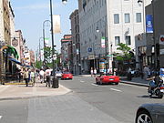
Downtown Trois-Rivières in June 2006.
Trois-Rivières hosts the FestiVoix de Trois-Rivières, a 10-day summer music festival which attracts in excess of 300,000 visitors annually.[26] The city also hosts the Festival International de la Poésie – an international poetry festival – as well as the Festival International Danse Encore,[27] and the MetalFest de Trois-Rivières every November. In 2009, Trois-Rivières was designated as the 2009 Cultural Capital of Canada for cities having a population of 125,000 or more.[28]
Trois-Rivières is officially the "Poetry Capital of Quebec".[29][30] Numerous plaques displaying poetic verses are installed throughout the centre of the city. An International Festival of Poetry is held annually in the first week of October.
Demographics[]
| Trois-Rivières | ||
|---|---|---|
| Year | Pop. | ±% |
| 1871 | 11,107 | — |
| 1881 | 12,340 | +11.1% |
| 1891 | 11,784 | −4.5% |
| 1901 | 13,540 | +14.9% |
| 1911 | 18,445 | +36.2% |
| 1921 | 33,072 | +79.3% |
| 1931 | 48,699 | +47.3% |
| 1941 | 59,685 | +22.6% |
| 1951 | 72,154 | +20.9% |
| 1956 | 83,189 | +15.3% |
| 1961 | 93,451 | +12.3% |
| 1966 | 99,974 | +7.0% |
| 1971 | 103,703 | +3.7% |
| 1976 | 106,031 | +2.2% |
| 1981 | 111,453 | +5.1% |
| 1986 | 114,675 | +2.9% |
| 1991 | 121,483 | +5.9% |
| 1996 | 124,417 | +2.4% |
| 2001 | 122,395 | −1.6% |
| 2006 | 126,323 | +3.2% |
| 2011 | 131,338 | +4.0% |
| 2014[31] | 134,802 | +2.6% |
| [32][33] | ||
Prior to amalgamation in 2001, the new city of Trois-Rivières was divided among six municipalities. The largest visible minority groups in Trois-Rivières are Blacks (2.2%) and Asians (1.4%).
Municipal population, pre-amalgamation (December 14, 2000)[34]
| Municipality | Population |
|---|---|
| Trois-Rivières | 48,285 |
| Cap-de-la-Madeleine | 32,927 |
| Trois-Rivières-Ouest | 24,170 |
| Saint-Louis-de-France | 7,798 |
| Pointe-du-Lac | 6,846 |
| Sainte-Marthe-du-Cap | 6,428 |
| Total | 126,454 |
Age structure[]
- 0–14 years: 16.1%
- 15–64 years: 68.6%
- 65 years and over: 15.3%
Religious groups[]
- Catholic: 93.7%
- Protestant and other Christian: 2.7%
- No religious affiliation: 3.3%
Administration[]
City Council[]
Since its incorporation in 1845, the city has had thirty-six mayors. The mayor presides over the Trois-Rivières City Council.
Municipal reorganization[]
On January 1, 2002, the former city of Trois-Rivières along with its neighbouring towns of Cap-de-la-Madeleine, Sainte-Marthe-du-Cap, Saint-Louis-de-France, Trois-Rivières-Ouest, and the municipality of Pointe-du-Lac, were combined to form the new city of Trois-Rivières.
Sport[]
Trois-Rivières has an internationally known racetrack named Circuit Trois-Rivières. The track hosts American Le Mans Series, SCCA Pro Racing Trans-Am Series, Star Mazda Series, World RX of Canada and the NASCAR Canadian Tire Series events.[35]
In baseball, Trois-Rivières is represented by the Canadian American Association of Professional Baseball's Trois-Rivières Aigles which play their home games at Stade Stereo+. In ice hockey, Trois-Rivières has had several teams in the Ligue Nord-Américaine de Hockey, typically with home games at the Colisée de Trois-Rivières. The city is also the site of the only remaining pari-mutuel (wagering) harness racing track in Quebec, Hippodrome de Trois-Rivières, which operates live standardbred racing from May through October. In 2014, the hippodrome has resurrected the Prix d'Été, a once major Canadian race for four-year-old pacers that had been contested in Montreal until 1992.
Transportation[]


Trois-Rivières aerial view.
Local bus service is provided by the Société de transport de Trois-Rivières. The Laviolette Bridge links Trois-Rivières to Bécancour of the Centre-du-Québec administrative region on the south shore of the Saint Lawrence River. The Laviolette Bridge is the only bridge across the Saint Lawrence River between Montreal and Quebec City; therefore it provides an important connection between the north and south shores of the river. Known for its impressive structure, its elegant aesthetics, the bridge has become a major landmark of Trois-Rivières and the Mauricie region. Approximately 40,000 vehicles cross the bridge each day. An airport also serves the city.
On April 8, 2014 during morning commute an SUV fell into a giant pothole in Trois-Rivières caused by heavy rain accumulation. Nobody was injured during the incident.[36]
The city hosts a major ice-free port on the Saint Lawrence River, handling about 300 ships per annum.[37]
Media[]
Islands[]

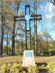
Cross Jacques Cartier on Saint-Quentin Island.
Saint-Quentin Island lies at the confluence of the Saint-Maurice River and St. Lawrence River, where the city of Trois-Rivières developed. With the islands Saint-Christophe and De La Poterie, it creates three channels at the mouth of the Saint-Maurice River, whee it flows into St. Lawrence River. The island was named in honor of judge Quentin Moral, also said to be a fur trader and one of the first dealers on this island.[38] It is now a centre of popular outdoor activities and relaxation at the hearth of city. The patron saint of the island is Quentin de Rome.
It was first inhabited by an Algonquin tribe who cultivate corn in the bottomlands of the river. On October 7, 1535, Jacques Cartier planted a cross on the island and proclaimed sovereignty of French on this territory. A commemorative wrought iron cross was erected at the site associated with Cartier's claim. The natural environment of Saint-Quentin has remained virtually unchanged. For nearly a century, it was not developed or cultivated.
Since 1930, the island has become more important as a destination for recreation. The island belonged at the time to Quebec Savings and Trust Company Limited and the Canada Power and Paper Corporation. The city bid for the land in 1933, but did not take ownership until November 3, 1947. During World War II, it was the site of a training camp for the Royal Canadian Navy. Services were gradually introduced in 1950.
The park and the beach on the island Saint-Quentin were officially inaugurated on June 24, 1962, in the presence of 5,000 people. There wee moee than 100 000 visitors that year.[39] Since then, many facilities have been developed on the island, including a marina, a bike path, an interpretative trail, an ice rink, and camping ground. Several happenings and festivals are held annually on the island.
Notable people[]

Historical marker commemorating the Sieur de Laviolette, founder of Trois-Rivières in Trois-Rivières.
- Jean Victor Allard, first francophone Chief of the Defence Staff
- Jean-Christophe Beaulieu, Canadian football player
- Steve Bégin, NHL hockey player
- Jean Béliveau, retired NHL hockey player for the Montreal Canadiens, inducted into the Hockey Hall of Fame in 1972
- Marc-André Bergeron, NHL hockey player
- Guy Bertrand, radio-TV personality and CBC French Radio and Television official linguistic advisor (French links:fr:C'est bien meilleur le matin)[40]
- Pierre Boucher, 1654 Governor of Trois Rivieres, Quebec, Canada and the official interpreter and agent to the Indian Tribes
- John Conley, politician
- Gilles Courteau, president of the Quebec Major Junior Hockey League
- Jacques De Noyon, worked in the fur trade as a coureur de bois, in 1688 he led an expedition beyond Lake Superior into territory previously unknown to fur traders, he was the first white man to explore this region[41]
- Médard Des Groseilliers and Pierre-Esprit Radisson, explorers, fur traders, founders of the Hudson's Bay Company[42]
- Maurice Duplessis, former Premier of Quebec (1936–39, 1944–59)
- André Dupont, former NHL hockey player
- Madeleine Ferron, writer
- Gérald Godin, politician and poet
- Annie Groovie, children's book author
- Jean Grou, an original settler of Trois-Rivières with a national monument localized at his original farm Coulèe Grou
- Aaron Hart, businessman
- Ezekiel Hart, entrepreneur and politician, and the first Jew to be elected to public office in Canada
- Norman Iceberg, a Canadian singer-songwriter
- Simon Kean, super heavyweight boxer who qualified to represent Canada in the 2012 Olympics
- Claude G. Lajoie, federal liberal politician (elected in 1971, 1972, 1974, 1979, 1980), building contractor, businessman
- Félix Leclerc, songwriter; worked in a Trois-Rivières radio station
- Eisha Marjara, Indo-Canadian filmmaker[43]
- Martyr, a technical death metal band
- The New Cities, a Canadian rock band, notable for their song "Dead End Countdown"
- Ghyslain Raza, president of the Trois-Rivieres Heritage Society, one of the first "internet celebrities" (the Star Wars Kid)[44]
- René Robert, former NHL hockey player
- Jean-Guy Talbot, former NHL hockey player, an arena with his name
- Éric Thériault, comic book artist and writer
- Luc Tousignant, the only French Canadian to start as quarterback in the Canadian Football League (Montreal Concordes)
- Denis Villeneuve, critically acclaimed, Oscar-nominated film director. Notable movies include Arrival, Blade Runner 2049, Sicario, Incendies, Prisoners and Enemy.
- Henri Wittmann, linguist
- Mikaël Zewski, light middleweight professional boxer
- Claude-Jean Allouez
- Jean-Baptiste Badeaux
- George Baptist
- Guillaume Baudry
- Jacques Baudry de Lamarche
- Jean-Baptiste Baudry
- Pierre-Stanislas Bédard
- Claude-Michel Bégon de la Cour
- Mathew Bell
- Amable Berthelot
- François Bigot (royal notary)
- Raymond Blaise Des Bergères de Rigauville
- Louis-Charles Boucher de Niverville
- Jean Bouillet de la Chassaigne
- Marc-Antoine Bras-De-Fer de Chateaufort
- François-Joseph Bressani
- Ralph Burton
- Jacques Buteux
- Edward Carter (Canadian politician)
- François de Champflour
- Pierre Chastellain
- Henry Edward Clarke
- Thomas Coffin (pre-confederation Canadian politician)
- Thomas Cooke (bishop)
- Guillaume Couture
- Antoine de Crisafy
- Lemuel Cushing
- Joseph Denis
- Jean Desfossés
- François Desjordy Moreau de Cabanac
- Jean-Baptiste-Éric Dorion
- Josué Dubois Berthelot de Beaucours
- Pierre-Benjamin Dumoulin
- Marie-Anne Gaboury
- François de Galiffet de Caffin
- Pierre Gaultier de Varennes, sieur de La Vérendrye
- René Gaultier de Varennes
- Charles-Borromée Genest
- Samuel Genest
- René Godefroy, sieur de Linctot
- William Grant (fur trader)
- François Gravé Du Pont
- Edward Greive
- Bartholomew Gugy
- Conrad Gugy
- Louis Gugy
- Guillaume Guillemot
- Jean-Baptiste Hertel de Rouville
- Jean-Baptiste-Melchior Hertel de Rouville
- Frederick Haldimand
- Peter Frederick Haldimand
- Benjamin Hart (businessman)
- Moses Hart
- Joseph-François Hertel de la Fresnière
- Henry Judah
- René-Joseph Kimber
- Joseph de La Roche Daillon
- Nicolas-Eustache Lambert Dumont
- Sieur de Laviolette
- Étienne Le Blanc
- Joseph-Dominique-Emmanuel Le Moyne de Longueuil
- Paul-Joseph Le Moyne de Longueuil
- William Henry Lee
- John Lees (politician)
- Charles Legardeur de Tilly
- Michel Leneuf de la Vallière de Beaubassin
- Jacques Leneuf de La Poterie
- Thomas-Jean-Jacques Loranger
- Louis-Philippe Mariauchau d'Esgly
- Alexander MacKay (fur trader)
- Constant le Marchand de Lignery
- Dominique Mondelet (seigneur)
- Jean-Marie Mondelet
- Nicholas Montour
- Charles le Moyne de Longueuil et de Châteauguay
- Charles le Moyne de Longueuil, Baron de Longueuil
- Louis-Philippe Normand
- Charles Richard Ogden
- Édouard-Louis Pacaud
- Joseph-François Perrault
- Étienne Pézard de la Tousche Champlain
- Phillip Louis (Phil) Perew
- Antoine Polette
- François Poulin de Francheville
- François Provost
- Claude de Ramezay
- Étienne Ranvoyzé
- Louis-François Richer Laflèche
- Pierre de Rigaud, Marquis de Vaudreuil-Cavagnial
- François-Pierre Rigaud de Vaudreuil
- Frederika Charlotte Riedesel
- Pierre de Sales Laterrière
- James Smith (1806–68)
- William Thompson (general)
- Joseph-Édouard Turcotte
- Joseph-Rémi Vallières de Saint-Réal
- Pierre Vézina
Sister city[]
 Châteaudun, France
- Tours, France
See also[]
- List of regional county municipalities and equivalent territories in Quebec
- 1925 Charlevoix–Kamouraska earthquake
- École secondaire Chavigny
- Marcel-Léger Ecological Reserve
- List of governors of Trois-Rivières
- List of towns in New France
- List of population centres in Quebec
- List of towns in Quebec
References[]
- ^ Reference number 63803 of the Commission de toponymie du Québec (French)
- ^ a b Geographic code 37067 in the official Répertoire des municipalités (French)
- ^ a b "Census Profile — Trois-Rivières". Canada 2011 Census. Statistics Canada. 2012-02-08. http://www12.statcan.gc.ca/census-recensement/2011/dp-pd/prof/details/page.cfm?Lang=E&Geo1=CSD&Code1=2437067&Geo2=PR&Code2=24&Data=Count&SearchText=Trois-Rivieres&SearchType=Begins&SearchPR=01&B1=All&Custom=. Retrieved 24 May 2012.
- ^ a b "Census Profile — Trois-Rivières, Population Centre". Canada 2011 Census. Statistics Canada. 2012-02-08. http://www12.statcan.gc.ca/census-recensement/2011/dp-pd/prof/details/page.cfm?Lang=E&Geo1=POPC&Code1=0953&Geo2=PR&Code2=24&Data=Count&SearchText=Trois-Rivieres&SearchType=Begins&SearchPR=01&B1=All&GeoLevel=PR&GeoCode=0953&TABID=1. Retrieved 24 May 2012.
- ^ a b "Census Profile — Trois-Rivières, Census Metropolitan Area". Canada 2011 Census. Statistics Canada. 2012-02-08. http://www12.statcan.gc.ca/census-recensement/2011/dp-pd/prof/details/page.cfm?Lang=E&Geo1=CMA&Code1=442&Geo2=PR&Code2=24&Data=Count&SearchText=Trois-Rivieres&SearchType=Begins&SearchPR=01&B1=All&GeoLevel=PR&GeoCode=442&TABID=1. Retrieved 24 May 2012.. The census metropolitan area consists of Trois-Rivières, Bécancour, Champlain, Saint-Luc-de-Vincennes, Saint-Maurice, Wôlinak, Yamachiche. In the 2006 census, the census metropolitan area had not included Saint-Luc-de-Vincennes or Yamachiche.
- ^ http://www12.statcan.gc.ca/census-recensement/2016/dp-pd/prof/details/page.cfm?Lang=E&Geo1=CSD&Code1=2437067&Geo2=CD&Code2=2437&Data=Count&SearchText=Trois-Rivieres&SearchType=Begins&SearchPR=01&B1=All&TABID=1%7Cpopulation_as_of = 2016
- ^ https://www.thecanadianencyclopedia.ca/fr/article/trois-rivieres
- ^ Roy-Sole, Monique. "A Tale of Tenacity", Canadian Geographic Magazine, April 2009, Vol. 129, No. 2, p. 31.
- ^ Territorial Division Act. Revised Statutes of Quebec D-11.
- ^ untitled
- ^ Report Concerning the Archives of Canada for the year 1905. Vol I. of III., p. li.
- ^ Richard Preston, Canada's RMC: A History of the Royal Military College of Canada, U of Toronto Press for RMC Club.
- ^ "Forges du Saint-Maurice National Historic Site of Canada". Parks Canada. Archived from the original on 2007-11-20. https://web.archive.org/web/20071120041617/http://www.pc.gc.ca/lhn-nhs/qc/saintmaurice/index_e.asp. Retrieved 2009-03-27.
- ^ Roy-Sole, Monique. "A Tale of Tenacity", Canadian Geographic Magazine, April 2009, Vol. 129, No. 2, p. 32
- ^ "Le Port de Trois-Rivières". http://www.porttr.com/en/?faq.html#6. Retrieved 2009-03-27.
- ^ Roy-Sole, Monique. "A Tale of Tenacity", Canadian Geographic Magazine, April 2009, Vol. 129, No. 2, p. 35
- ^ Roy-Sole, Monique. "A Tale of Tenacity", Canadian Geographic Magazine, April 2009, Vol. 129, No. 2, p. 36
- ^ Roy-Sole, Monique. "A Tale of Tenacity", Canadian Geographic Magazine, April 2009, Vol. 129, No. 2, p. 37
- ^ a b c d "Trois-Rivières". Canadian Climate Normals 1981–2010. Environment Canada. http://climate.weather.gc.ca/climate_normals/results_1981_2010_e.html?stnID=5201&lang=e&dCode=1&province=QUE&provBut=Go&month1=0&month2=12. Retrieved May 12, 2014.
- ^ "Daily Data Report for July 1953". Canadian Climate Data. Environment Canada. http://climate.weather.gc.ca/climate_data/daily_data_e.html?hlyRange=%7C&dlyRange=1934-11-01%7C1986-08-31&mlyRange=1934-01-01%7C1986-12-01&StationID=5292&Prov=QC&urlExtension=_e.html&searchType=stnName&optLimit=specDate&StartYear=1840&EndYear=2017&selRowPerPage=25&Line=0&searchMethod=contains&Month=7&Day=1&txtStationName=trois&timeframe=2&Year=1953. Retrieved 11 January 2017.
- ^ "Daily Data Report for February 1923". Canadian Climate Data. Environment Canada. http://climate.weather.gc.ca/climate_data/daily_data_e.html?hlyRange=%7C&dlyRange=1920-12-01%7C1932-04-30&mlyRange=1920-01-01%7C1932-12-01&StationID=5209&Prov=QC&urlExtension=_e.html&searchType=stnName&optLimit=yearRange&StartYear=1840&EndYear=2017&selRowPerPage=25&Line=0&searchMethod=contains&Month=2&Day=11&txtStationName=cap+de+la&timeframe=2&Year=1923. Retrieved 11 January 2017.
- ^ "Cap De La Madeleine". Canadian Climate Data. Environment Canada. http://climate.weather.gc.ca/historical_data/search_historic_data_stations_e.html?searchType=stnName&timeframe=1&txtStationName=cap+de+la&searchMethod=contains&optLimit=yearRange&StartYear=1840&EndYear=2017&Year=2017&Month=1&Day=11&selRowPerPage=25. Retrieved 11 January 2017.
- ^ "Trois Rivieres". Canadian Climate Data. Environment Canada. http://climate.weather.gc.ca/historical_data/search_historic_data_stations_e.html?searchType=stnName&timeframe=1&txtStationName=trois&searchMethod=contains&StartYear=1840&EndYear=2017&optLimit=specDate&Year=1934&Month=11&Day=1&selRowPerPage=25. Retrieved 11 January 2017.
- ^ "Daily Data Report for December 2015". Canadian Climate Data. Environment Canada. http://climate.weather.gc.ca/climate_data/daily_data_e.html?hlyRange=1963-09-03%7C2017-01-10&dlyRange=2004-11-02%7C2017-01-08&mlyRange=%7C&StationID=8321&Prov=QC&urlExtension=_e.html&searchType=stnProx&optLimit=specDate&Month=12&Day=10&StartYear=1840&EndYear=2017&Year=2015&selRowPerPage=25&Line=2&txtRadius=25&optProxType=navLink&selCity=&selPark=&txtCentralLatDeg=46&txtCentralLatMin=22&txtCentralLatSec=0&txtCentralLongDeg=72&txtCentralLongMin=36&txtCentralLongSec=0&txtLatDecDeg=46.353611111111&txtLongDecDeg=72.516111111111&timeframe=2. Retrieved 11 January 2017.
- ^ "Nicolet". Canadian Climate Normals 1981–2010. Environment Canada. ftp://ftp.tor.ec.gc.ca/Pub/Normals/English/QUE/QUE_L'AL-QUEB_ENG.csv. Retrieved 11 January 2017.
- ^ "Le FestiVoix de Trois-Rivières". http://www.festivoix.com. Retrieved 2009-04-03.
- ^ "Accueil". Festival encore. http://www.festival-encore.com. Retrieved 2012-07-07.
- ^ Roy-Sole, Monique. "A Tale of Tenacity", Canadian Geographic Magazine, April 2009, Vol. 129, No. 2, p. 38
- ^ "Tourisme Trois-Rivières". http://www.tourismetroisrivieres.com/fr/evenements/festival-international-de-la-poesie.aspx.
- ^ "Festival International de la Poésie". http://www.fiptr.com/propos_historique.html.
- ^ "Page inexistante : Erreur 404 - MAMOT - Ministère des Affaires municipales et de l'Occupation du territoire". http://www.mamrot.gouv.qc.ca/repertoire-des-municipalites/fiche/municipalite/37067/.
- ^ "Évolution démographique des 10 principales villes du Québec (sur la base de 2006) selon leur limites territoriales actuelles1, Recensements du Canada de 1871 à 2006" (in French). Institut de la statistique du Québec. 2008-02-01. Archived from the original on 2013-10-06. https://web.archive.org/web/20131006173408/http://www.stat.gouv.qc.ca/donstat/societe/demographie/dons_regnl/regional/Tableau_top_10.htm. Retrieved 2012-02-08.
- ^ These figures correspond to the territory of the city of Trois-Rivières following the municipal reorganizations of 2002 and 2006.
- ^ "Ville de Trois-Rivières". Laville.v3r.net. Archived from the original on 2012-06-09. https://web.archive.org/web/20120609005739/http://laville.v3r.net/portail/index.aspx?sect=0&module=5&module2=1&MenuID=201&CPage=1. Retrieved 2012-07-07.
- ^ "Grand Prix de Trois-Rivières". Gp3r.com. http://www.gp3r.com/. Retrieved 2012-07-07.
- ^ "Giant pothole swallows SUV". http://www.cbc.ca/news/canada/montreal/giant-pothole-swallows-suv-in-trois-rivi%C3%A8res-1.2602793?cmp=fbtl.
- ^ "Port of Trois Riviere". Shipping Guides Limited. https://www.findaport.com/port-of-trois-rivieres. Retrieved 13 December 2018.
- ^ "Parc de l'île Saint-Quentin (Québec, Canada)". https://www.facebook.com/pages/Parc-de-l%C3%AEle-Saint-Quentin-%C3%A0-Trois-Rivi%C3%A8res/212154122147344.
- ^ Trois-Rivières, Ville de. "Accueil - Site officiel de la Ville de Trois-Rivières". http://www.v3r.net/.
- ^ "Le français au micro | zone radio". Radio-Canada.ca. http://www.radio-canada.ca/radio/francaisaumicro/. Retrieved 2012-01-02.
- ^ "Jacques de Noyon 1668-1745". Ontarioplaques.com. Archived from the original on 2012-03-25. https://web.archive.org/web/20120325212313/http://www.ontarioplaques.com/Plaques_PQR/Plaque_RainyRiver04.html. Retrieved 2012-07-07.
- ^ http://www.cbc.ca/history/EPCONTENTSE1EP6CH1PA5LE.html Hudson's Bay Company Beginnings. Retrieved on 2015-02-11.
- ^ Black, Barbara. "Air India disaster hit Concordia hard" (Archive). Conordia's Thursday Report. April 21, 2005. Volume 29, No. 14. Retrieved on November 22, 2014.
- ^ WHERE ARE THEY NOW? The 'Star Wars Kid' Sued The People Who Made Him Famous. Business Insider (2010-05-12). Retrieved on 2013-07-12.
- ^ Climate data was recorded at Cap-de-la-Madeleine from December 1920 to April 1932 and at Trois-Rivières from November 1934 to present.
External links[]
| Wikivoyage has a travel guide for Trois-Rivières. |
- (French) Official site of Trois-Rivières
- Tourisme Trois-Rivières Municipal tourist office
- Pictures of Trois-Rivières (2001 to date)

|
Saint-Étienne-des-Grès | Notre-Dame-du-Mont-Carmel / Saint-Maurice | Champlain |
|
| Yamachiche | ||||
 Trois-Rivières | ||||
| Lake Saint Pierre | Saint Lawrence River Nicolet |
Saint Lawrence River Bridge to: Bécancour |
Template:Administrative divisions of Quebec region
| |||||
Template:Chemin du Roy
| This page uses content from the English language Wikipedia. The original content was at Trois-Rivières. The list of authors can be seen in the page history. As with this Familypedia wiki, the content of Wikipedia is available under the Creative Commons License. |