| ||||||||||||||
| Thomas County, Kansas | |
 Location in the state of Kansas | |
 Kansas's location in the U.S. | |
| Founded | 8 October 1885 |
|---|---|
| Named for | George Henry Thomas[1] |
| Seat | Colby |
| Area - Total - Land - Water |
1,074.90 sq mi (2,784 km²) 1,074.78 sq mi (2,784 km²) 0.11 sq mi (0 km²), 0.01% |
| Population - (2010) - Density |
7,900 7.1/sq mi (2.7/km²) |
| Time zone | Central: UTC-6/-5 |
| Website | ThomasCountyKS.com |
Thomas County (standard abbreviation: TH) is a county located in the U.S. state of Kansas. As of the 2010 census, the county population was 7,900.[2] Its county seat is Colby.[3]
History[]
The county was founded in October 8, 1885. It was named for George Henry Thomas, a Union General during the American Civil War, hero of the Battle of Chickamauga. The townships of the county were named after the soldiers that died at the Battle of Chickamauga.[4]
Law and government[]
Thomas County was a prohibition, or "dry", county until the Kansas Constitution was amended in 1986 and voters approved the sale of alcoholic liquor by the individual drink with a 30% food sales requirement.[5]
Geography[]
According to the 2000 census, the county has a total area of 1,074.90 square miles (2,784.0 km2), of which 1,074.78 square miles (2,783.7 km2) (or 99.99%) is land and 0.11 square miles (0.28 km2) (or 0.01%) is water.[6]
Adjacent counties[]
- Rawlins County (north)
- Decatur County (northeast)
- Sheridan County (east)
- Gove County (southeast)
- Logan County (south)
- Sherman County (west)
Demographics[]
| Historical populations | |||
|---|---|---|---|
| Census | Pop. | %± | |
| 1900 | 4,112 | ||
| 1910 | 5,455 | 32.7% | |
| 1920 | 5,517 | 1.1% | |
| 1930 | 7,334 | 32.9% | |
| 1940 | 6,425 | −12.4% | |
| 1950 | 7,572 | 17.9% | |
| 1960 | 7,358 | −2.8% | |
| 1970 | 7,501 | 1.9% | |
| 1980 | 8,451 | 12.7% | |
| 1990 | 8,258 | −2.3% | |
| 2000 | 8,180 | −0.9% | |
| 2010 | 7,900 | −3.4% | |

Age pyramid
As of the census[7] of 2000, there were 8,180 people, 3,226 households, and 2,125 families residing in the county. The population density was 8 people per square mile (3/km²). There were 3,562 housing units at an average density of 3 per square mile (1/km²). The racial makeup of the county was 97.14% White, 0.43% Black or African American, 0.33% Native American, 0.27% Asian, 0.02% Pacific Islander, 0.95% from other races, and 0.86% from two or more races. 1.85% of the population were Hispanic or Latino of any race.
There were 3,226 households out of which 32.90% had children under the age of 18 living with them, 56.10% were married couples living together, 6.90% had a female householder with no husband present, and 34.10% were non-families. 28.40% of all households were made up of individuals and 11.70% had someone living alone who was 65 years of age or older. The average household size was 2.45 and the average family size was 3.04.
In the county the population was spread out with 26.30% under the age of 18, 13.50% from 18 to 24, 24.40% from 25 to 44, 21.20% from 45 to 64, and 14.60% who were 65 years of age or older. The median age was 35 years. For every 100 females there were 94.60 males. For every 100 females age 18 and over, there were 91.50 males.
The median income for a household in the county was $37,034, and the median income for a family was $45,931. Males had a median income of $33,833 versus $21,310 for females. The per capita income for the county was $19,028. About 6.60% of families and 9.70% of the population were below the poverty line, including 5.90% of those under age 18 and 7.50% of those age 65 or over.
Cities and towns[]
Incorporated cities[]
Name and population (2004 estimate):
- Colby, 5,145 (county seat)
- Brewster, 268
- Rexford, 153
- Gem, 93
- Menlo, 56
- Oakley (only a small portion)
Townships[]
Thomas County is divided into thirteen townships. The city of Colby is considered governmentally independent and is excluded from the census figures for the townships. Geographically, Colby is surrounded by Morgan Township. In the following table, the population center is the largest city (or cities) included in that township's population total, if it is of a significant size.
| Township | FIPS | Population center |
Population | Population density /km² (/sq mi) |
Land area km² (sq mi) |
Water area km² (sq mi) |
Water % | Geographic coordinates |
|---|---|---|---|---|---|---|---|---|
| Barrett | 04325 | 124 | 0 (1) | 276 (107) | 0 (0) | 0.01% | ||
| East Hale | 19475 | 137 | 1 (3) | 140 (54) | 0 (0) | 0% | ||
| Kingery | 36925 | 93 | 0 (1) | 373 (144) | 0 (0) | 0% | ||
| Lacey | 37425 | Gem | 132 | 1 (4) | 92 (36) | 0 (0) | 0% | |
| Menlo | 45775 | Menlo | 112 | 1 (2) | 140 (54) | 0 (0) | 0% | |
| Morgan | 48200 | Colby outskirts | 755 | 3 (7) | 271 (105) | 0 (0) | 0% | |
| North Randall | 51300 | 107 | 1 (2) | 138 (53) | 0 (0) | 0.03% | ||
| Rovohl | 61525 | 143 | 1 (1) | 277 (107) | 0 (0) | 0% | ||
| Smith | 65900 | Rexford | 213 | 2 (6) | 93 (36) | 0 (0) | 0.03% | |
| South Randall | 66875 | Oakley outskirts | 267 | 1 (2) | 279 (108) | 0 (0) | 0.04% | |
| Summers | 68975 | 197 | 1 (1) | 373 (144) | 0 (0) | 0% | ||
| Wendell | 76650 | 84 | 0 (1) | 183 (71) | 0 (0) | 0.02% | ||
| West Hale | 76975 | Brewster | 366 | 3 (7) | 140 (54) | 0 (0) | 0% |
Education[]
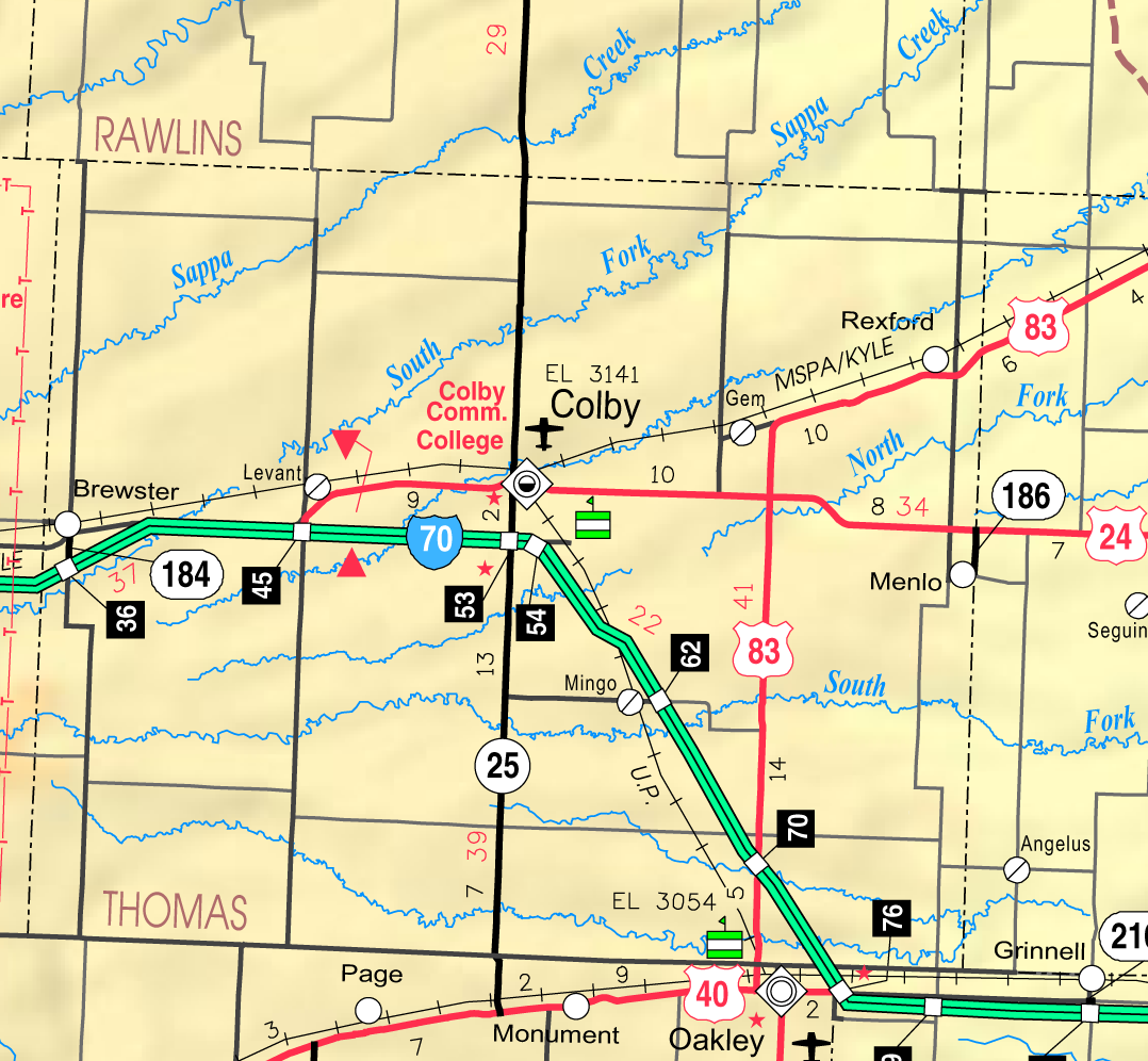

2005 KDOT Map of Thomas County from KDOT (map legend)
Unified school districts[]
See also[]
Information on this and other counties in Kansas
- List of counties in Kansas
- List of Kansas county name etymologies
- National Register of Historic Places listings in Kansas
- Kansas locations by per capita income
Other information for Kansas
- List of cities in Kansas
- List of unified school districts in Kansas
- List of colleges and universities in Kansas
References[]
- ^ "A Brief History of Thomas County, Kansas and the Thomas County Courthouse". Thomas County, Kansas. http://thomascountyks.com/About/History/tabid/10272/Default.aspx. Retrieved 2012-11-4.
- ^ "2010 County Population and Housing Occupancy Status". U.S. Census Bureau. http://factfinder2.census.gov/faces/tableservices/jsf/pages/productview.xhtml?pid=DEC_10_PL_GCTPL2.ST05&prodType=table. Retrieved April 9, 2011.
- ^ "Find a County". National Association of Counties. http://www.naco.org/Counties/Pages/FindACounty.aspx. Retrieved 2011-06-07.
- ^ A Brief History of Thomas County, Kansas
- ^ "Map of Wet and Dry Counties". Alcoholic Beverage Control, Kansas Department of Revenue. November 2006. http://www.ksrevenue.org/abcwetdrymap.htm. Retrieved 2007-12-28.
- ^ "Census 2000 U.S. Gazetteer Files: Counties". United States Census. http://www.census.gov/tiger/tms/gazetteer/county2k.txt. Retrieved 2011-02-13.
- ^ "American FactFinder". United States Census Bureau. http://factfinder.census.gov. Retrieved 2008-01-31.
Further reading[]
- History of the State of Kansas; William G. Cutler; A.T. Andreas Publisher; 1883. (Online HTML eBook)
- Kansas : A Cyclopedia of State History, Embracing Events, Institutions, Industries, Counties, Cities, Towns, Prominent Persons, Etc; 3 Volumes; Frank W. Blackmar; Standard Publishing Co; 944 / 955 / 824 pages; 1912. (Volume1 - Download 54MB PDF eBook),(Volume2 - Download 53MB PDF eBook), (Volume3 - Download 33MB PDF eBook)
External links[]
- Official
- General Information
- Kansas County Data
- Thomas County local history and genealogy
- Maps
- Thomas County Map, KDOT
- Kansas Highway Map, KDOT
- Kansas Railroad Map, KDOT
- Kansas School District Boundary Map, KSDE
+

|
Rawlins County | Decatur County |
| |
| Sherman County | Sheridan County | |||
 Thomas County, Kansas | ||||
| Logan County | Gove County |
| |||||
| This page uses content from the English language Wikipedia. The original content was at Thomas County, Kansas. The list of authors can be seen in the page history. As with this Familypedia wiki, the content of Wikipedia is available under the Creative Commons License. |