| ||||||||||||||
| Tangipahoa Parish, Louisiana | |
 Location in the state of Louisiana | |
 Louisiana's location in the U.S. | |
| Founded | 1868 |
|---|---|
| Named for | Acolapissa word meaning ear of corn or those who gather corn |
| Seat | Amite |
| Largest city | Hammond |
| Area - Total - Land - Water |
823 sq mi (2,132 km²) 790 sq mi (2,047 km²) 33 sq mi (85 km²), 3.99% |
| Population - (2000) - Density |
100,588 127/sq mi (49/km²) |
| Time zone | Central: UTC-6/-5 |
| Website | www.tangipahoa.org |
Tangipahoa Parish is a parish located in the U.S. state of Louisiana. The parish seat is Amite and as of 2000, the population was 100,588. Tangipahoa comes from an Acolapissa word meaning "ear of corn" or "those who gather corn."
Geography
The parish has a total area of 2,132 km² (823 sq mi). 2,047 km² (790 sq mi) of it is land and 85 km² (33 sq mi) of it (3.99%) is water.
Major Highways
 Interstate 12
 Interstate 55
- U.S. Route 51
- Louisiana Highway 10
- Louisiana Highway 16
- Louisiana Highway 22
- Louisiana Highway 38
- Louisiana Highway 40
- U.S. Route 190
Adjacent counties, parishes and features
- Amite County (northwest)
- Pike County (northeast)
- St. Tammany Parish and Washington Parish (east)
- Lake Pontchartrain (southeast)
- St. John the Baptist Parish (south)
- Livingston Parish and St. Helena Parish (west)
Demographics
As of the census² of 2000, there were 100,588 people, 36,558 households, and 25,773 families residing in the parish. The population density was 49/km² (127/sq mi). There were 40,794 housing units at an average density of 20/km² (52/sq mi). The racial makeup of the parish was 69.76% White, 28.35% Black or African American, 0.24% Native American, 0.39% Asian, 0.01% Pacific Islander, 0.46% from other races, and 0.78% from two or more races. 1.53% of the population were Hispanic or Latino of any race.
There were 36,558 households out of which 35.30% had children under the age of 18 living with them, 49.90% were married couples living together, 16.20% had a female householder with no husband present, and 29.50% were non-families. 24.00% of all households were made up of individuals and 8.40% had someone living alone who was 65 years of age or older. The average household size was 2.66 and the average family size was 3.19.
In the parish the population was spread out with 27.70% under the age of 18, 12.70% from 18 to 24, 27.70% from 25 to 44, 21.20% from 45 to 64, and 10.60% who were 65 years of age or older. The median age was 32 years. For every 100 females there were 93.00 males. For every 100 females age 18 and over, there were 88.60 males.
The median income for a household in the parish was $29,412, and the median income for a family was $36,731. Males had a median income of $31,576 versus $20,066 for females. The per capita income for the parish was $14,461. About 18.00% of families and 22.70% of the population were below the poverty line, including 28.60% of those under age 18 and 20.10% of those age 65 or over.
Cities and towns
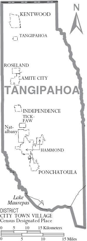
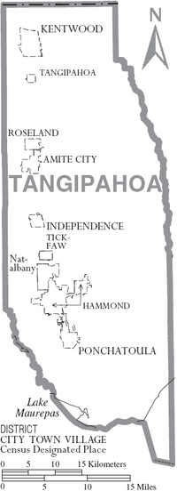
Map of Tangipahoa Parish, Louisiana With Municipal Labels
Education
The parish is served by the Tangipahoa Parish School System [1].
External links
| |||||||||||||||||

| ||||||||||||||||||||||||||
| This page uses content from the English language Wikipedia. The original content was at Tangipahoa Parish, Louisiana. The list of authors can be seen in the page history. As with this Familypedia wiki, the content of Wikipedia is available under the Creative Commons License. |