| Sylva, North Carolina | |
|---|---|
| — Town — | |
 |
|
| Coordinates: Coordinates: | |
| Country | United States |
| State | North Carolina |
| County | Jackson |
| Incorporated | 1889 |
| Government | |
| • Mayor | Maurice Moody |
| Area | |
| • Total | 3.2 sq mi (8.3 km2) |
| • Land | 3.2 sq mi (8.3 km2) |
| • Water | 0 sq mi (0 km2) 0% |
| Elevation | 2,036 ft (839 m) |
| Population (2000) | |
| • Total | 2,435 |
| • Density | 1,191.8/sq mi (293.3/km2) |
| Time zone | Eastern (UTC-5) |
| • Summer (DST) | EDT (UTC-4) |
| ZIP code | 28779 |
| Area code(s) | 828 |
| FIPS code | 37-66500[1] |
| GNIS feature ID | 0995798[2] |
| Website | Town of Sylva, NC |
Sylva is an incorporated town located in central Jackson County, in the Great Smoky Mountains of Western North Carolina, United States of America. As of the 2000 census, the town had a total population of 2,435. It is the county seat[3], having taken over from nearby Webster in 1913.
Geography[]
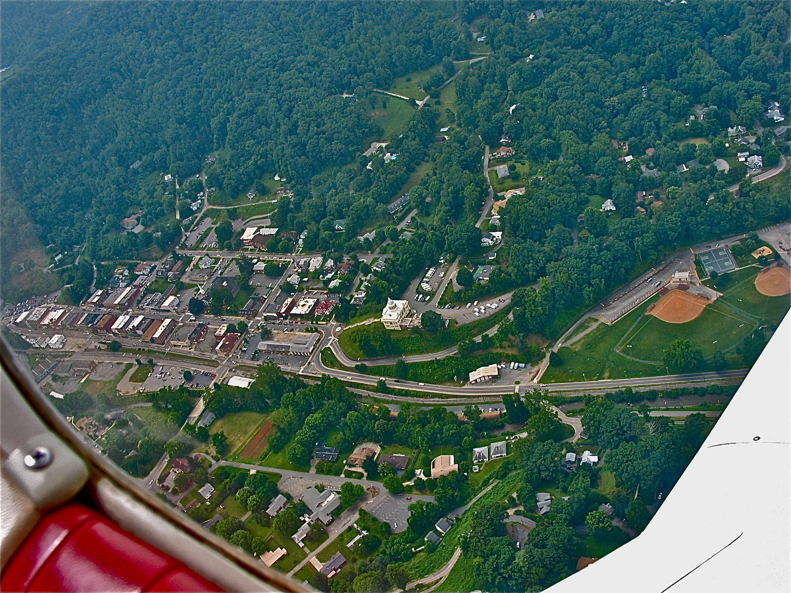
Downtown Sylva from an airplane in 2003
Sylva is located at .[4] The town's altitude above sea level is 2,051 feet (625 meters.)
According to the United States Census Bureau, the town has a total area of 3.2 square miles (8.3 km2), all of it land.
Demographics[]
As of the census[1] of 2000, there were 2,435 people, 1,137 households, and 608 families residing in the town. The population density was 759.7 people per square mile (292.9/km2). There were 1,283 housing units at an average density of 400.3 per square mile (154.3/km2). The racial makeup of the town was 89.16% White, 4.68% African American, 1.60% Native American, 1.31% Asian, 0.82% from other races, and 2.42% from two or more races. Hispanic or Latino of any race were 2.51% of the population.
There were 1,137 households out of which 21.7% had children under the age of 18 living with them, 37.1% were married couples living together, 12.5% had a female householder with no husband present, and 46.5% were non-families. 39.6% of all households were made up of individuals and 16.2% had someone living alone who was 65 years of age or older. The average household size was 2.04 and the average family size was 2.74.
In the town the population was spread out with 18.4% under the age of 18, 12.0% from 18 to 24, 26.7% from 25 to 44, 22.6% from 45 to 64, and 20.3% who were 65 years of age or older. The median age was 39 years. For every 100 females, there were 89.2 males. For every 100 females age 18 and over, there were 84.1 males.
The median income for a household in the town was $26,432, and the median income for a family was $36,711. Males had a median income of $25,526 versus $22,401 for females. The per capita income for the town was $17,348. About 13.9% of families and 19.6% of the population were below the poverty line, including 26.9% of those under age 18 and 18.6% of those age 65 or over.
History[]

The endangered CJ Harris Sylva Supply Company Building from 1902 on Main Street predates most other downtown buildings by 20 years.
Sylva is named for William D. Sylva, a Danish handyman who spent a month in the home of General E. R. Hampton, whom owned much of the land where Downtown Sylva now sits. When the town applied for a post office, Hampton asked his young daughter Mae what the town's name should be. She liked the handyman so much she said, "Sylva."[5] This is disputed, as its investigation has turned up that William D. Sylva wasn't Danish, and likely didn't have the last name of Sylva. His last name was "Selvey," the letter that he wrote to the town was likely Spanish, not Danish, and he was probably from the Little Canada Community. To support this, his daughter's maiden last name was Selvey according to genealogical archives, and her daughter who recently came to the town also said the real last name of "William D. Sylva" was "Selvey" instead.[6] The town became the county seat in 1913 after the county voted to move from Webster to Sylva. Subsequently, Webster declined because the railroad didn't come to that town and all the business left. The Jackson County Courthouse sits dramatically on a hill at the end of Main Street. It is slated to become part of the new Jackson County Library, which will be housed in a 20,000sq ft addition at the back of the building. The town has within its limits the main county high school, Smoky Mountain High School, the county Library, county Hospital, Justice Center, and two K-8 Elementary Schools in the vicinity of the town, Scotts Creek east of town, and Fairview located behind the High School. The town was also once the only town in the United States with a waterfall within its incorporated limits, Dills Falls, but the waterfall was destroyed to make way for the 4-lane Sylva Bypass US 74/23 in 1973. The town had the first municipally owned swimming pool west of Asheville, built by the WPA of Stone and Concrete in 1938, it was demolished in 1969 to make way for the current pool. Franklin D. Roosevelt and Thomas Edison both traveled through Sylva, Edison in 1911 and FDR in 1936, respectively.
Parks[]
The town has four parks, Poteet and Bridge Park, both along Scotts Creek and connected by a bridge over the creek. Mark Watson Park, located in a depression behind the historic courthouse that once was the campus for Sylva High School and Sylva Elementary School and before that, fairgrounds, and Bryson Park on Chipper Curve Road across from the Jackson Paper Recycling Plant. Poteet Park has a large playground, sand volleyball court, basketball court, picnic pavilion, and is located in close proximity to Roscoe Poteet Pool, which serves the community as a community pool and the county swim team as a 6-lane competition pool. The Bridge Park has a small stage pavilion for outdoor concerts, as well as a bridge spanning Scotts Creek and connecting to Poteet Park. Mark Watson Park has a picnic shelter, playground, two baseball fields, two basketball courts, and four tennis courts. It also has two old abandoned buildings, a large stone two story structure built in 1938 as an agricultural/vocational shops building for Sylva High School, and a metal garage building that once housed Jackson County Rescue Squad. Bryson Park has a picnic shelter, basketball court, and a playground.
Neighborhoods[]
The Sylva Area has many defined and named neighborhoods. They are as follows:

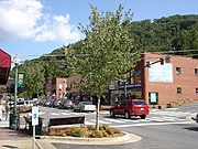
Downtown Sylva, corner of Main Street and Spring Street
-Downtown: The historical center of Sylva, was at one time home to many businesses, homes, people, the central High School, depot, some industry, and many churches. Today it is a historic and picturesque area defined by Main Street and Mill Street, which run as BUS 23 through the middle of the downtown area, as well as Cowan Street on the lower part of Kings Mountain, and Municipal Drive, at the base of College Hill, both of which define the southern and northern borders of the central downtown area. The intersection of Chipper Curve Road, BUS 23/East Main Street, and Municipal Drive as well as Keener Street define the eastern and western boundaries of the central business district. Mark Watson Park and US 23 Business/West Main Street West of Downtown are also considered part of Downtown, as the High School and many industries were once located in the area. The area is also defined by several buildings and parks, notably the Sylva First Baptist Church (1965), The C.J. Harris Building (1902), First Citizens Bank (1928), Sylva Fire Department (1980), all on Main Street, Roscoe Poteet Public Pool (1969) on Municipal Drive, the Hooper House (1906), the last remaining historic home on Main Street, and the Sylva First United Methodist Church (1917) on Jackson Street.
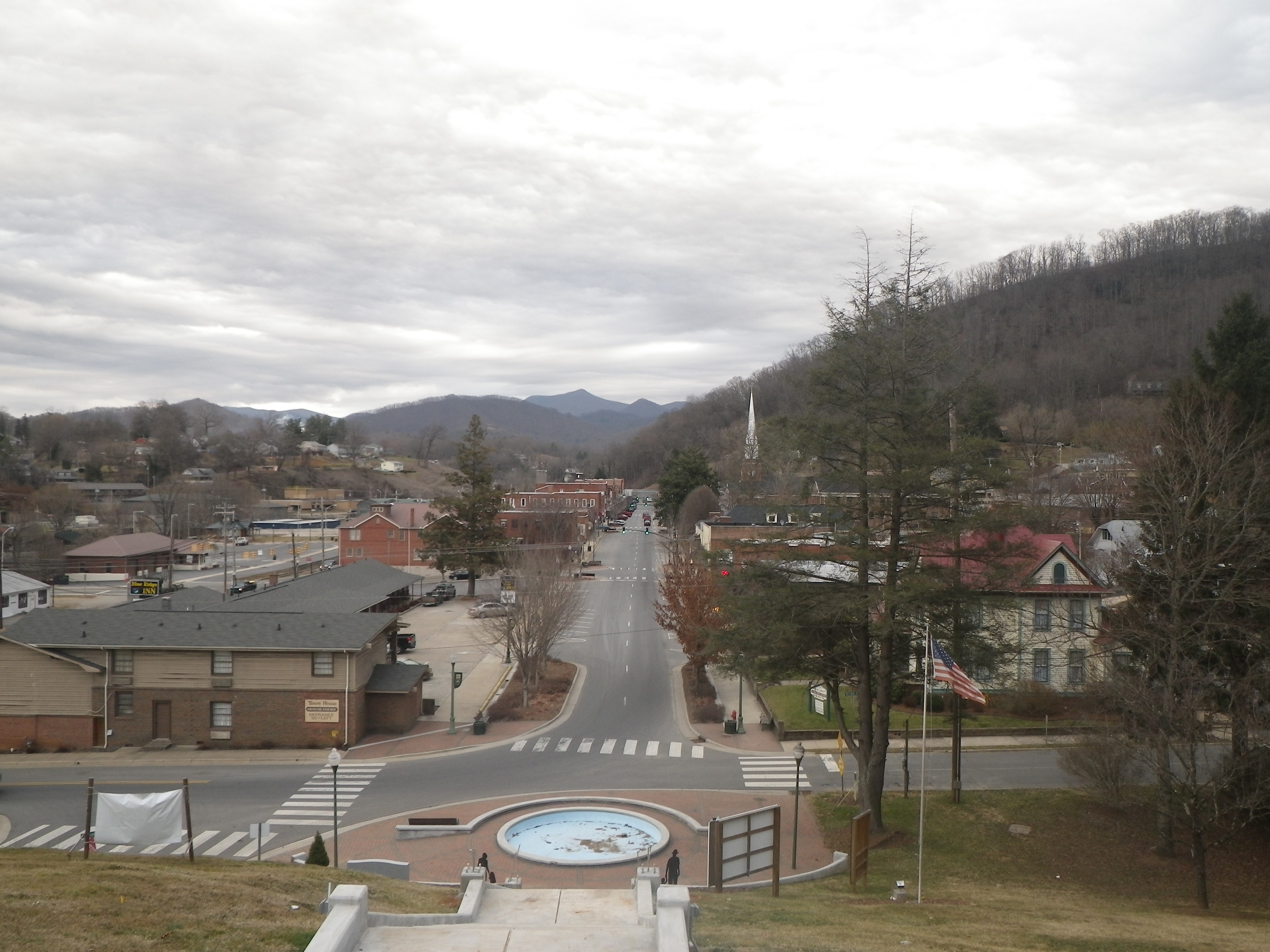

Downtown Sylva from the old Jackson County Courthouse
-Court House Hill: Named for the 1913 Jackson County Courthouse which sits at the end of Main Street, Court House Hill was once home to many working and middle class families, and was within walking distance to the old Central High and Elementary Schools at what is now Mark Watson Park. It extends up onto Kings Mountain from Savannah Drive, and back to Savannah Drive from the Courthouse and Main Street. It is defined by the historic Jackson County Court House (1913), new Jackson County Public Library (opening in May 2011, on the back of the historic court house), Sylva's Bicentennial Park (1976), and the old C.J. Harris Hospital (1920). Many older homes survive alongside newer ones, and there are many inexpensive rental units in the neighborhood, including the infamous Court House Hill Inn Apartments, in the old Hospital.


Sunrise Park from Wilkesdale Baptist Church.
-Sunrise Park: Located across Cope Creek from the US 23 Business/NC 107 Intersection, Sunrise Park is a large neighborhood that is barely visible until entered. It was historically a working class neighborhood, but has had many middle class homes added over the past 50 years. The neighborhood is defined by Cherry Street and Sunrise Park Road, which both allow access to the neighborhood, as well as Wilkesboro Baptist Church, which is the most prominent and easily viewed building in the neighborhood from the outside.

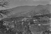
Downtown Sylva from Sylvan Heights in the 1920s
-Dills Cove: Once the location of Dills Falls, the neighborhood and Falls were cut in half by the construction of the Sylva Bypass, which is also known as the Great Smoky Mountains Expressway and US 74/23 in 1973. It occupies a hollow that extends a little over a mile from Dillsboro Road and also includes the sub-neighborhoods of Grindstaff Cove, Dillsboro Road, and the Sylvan Heights Subdivision. St. Mary's Catholic Church (1953), the Jackson County Justice Center (1994), and Jackson Plaza (1978) all define the neighborhood. It is also the location of the Sylva Post Office and the main entrance to downtown from US 74/23.
College Hill in the 1920s, prior to the closure of Sylva Collegiate Institute and construction of the water tower
-College Hill: Named for the former Sylva Collegiate Institute, a private Baptist Boarding School, which once occupied a campus on the very top of the hill in the middle of the neighborhood from 1910 until 1932. All traces of the former institution have all but vanished but a few photographs, records, stories, and a plaque that commemorates the location of the sign. There are many older homes located within the neighborhood, along with a few newer ones on the former campus of the institute. Many old working and middle class homes sit empty or neglected, and many apartment complexes and a sea kudzu are now located on the hill. It is home to a large, 50 foot tall water tower with a lighted star on top, a landmark for those entering Sylva on NC 107/US 23 Business from the south.


Fairview Elementary School, which serves Sylva, Webster, and Savannah.
-Lovedale/Love's Field/Fairview: Located near Webster, the neighborhood is centered around parts of NC 116, Fairview Road, and NC 107. Smoky Mountain High School and Fairview Elementary are located here, and it is one of the most southernly located neighborhoods to downtown. It has several big box stores and supermarkets, notably WalMart, Lowe's Home Improvement Warehouse, and an Ingles Supermarket, said to be the worst Ingles in North Carolina besides the store in Hazelwood.
-Hall Heights: Located along US 23 Business and NC 107, the neighborhood has two separate residential areas and lots of businesses located along the highways. The neighborhood's residential areas are an area on a hill known as Hall Heights, and a trailer park near Scotts Creek known as the Bridge Street Trailer Park. Prominent buildings include Ensley's Store, Bogarts, and the Sylva KFC.
-Cope Creek: Located along Cope Creek Road and between NC 107 and US 74/23, Cope Creek neighborhood is mostly residential, with a few commercial areas near the highways, including several gas stations, strip malls, fast food restaurants, and banks. Major landmarks include Cody's Hot Spot Gas Station (1998) on the corner of NC 107 and Cope Creek Road (A gas station under the name of Cody's has been located there since the 1950s), the Old Field Church and Cemetery (1830, the church later became Scotts Creek Baptist Church in Beta), and an historic victorian house that serves as a bed & breakfast. It also appears that more development is about to happen on two hills on the NC 107 end of Cope Creek, due to the fact that a network of roadways have been built on the sides of them and the trees on the hills have largely been cut down.
-Dillardtown: Located along Dillardtown Road and extending to US 23 Business, Dillardtown was the original homestead of the Dillard Family, whom later started a construction company and built the neighborhood between 1948 and 1970. The East Sylva Baptist Church is the dominant building of the neighborhood, with a tall spire and three floors, built in the mid-1950s and replaced an earlier stone church nearby. Dillardtown is home to working and middle class families and has a large stock of brick and wood-frame ranch houses from the 1950s and 1960s.
-Tannery Flats: Located East of Downtown Sylva, Tannery Flats is named for the Harris-Rees Tannery, which operated on the location until 1953. The Mead Corporation also opened a factory next to the tannery in 1928, and later bought the old tannery. In 1955, Mead expanded and relocated NC 107 and Scotts Creek about 100 feet. This called for the demolition of several buildings, and an A&P Supermarket was built on the "reclaimed" land. Mead closed in the mid-1980s, and Jackson Paper opened a few years later. The neighborhood extends along Chipper Curve Road and Skyland Drive (Both old US 19/23), and is where Bryson Park is located as well.
-Beta: (Pronounced "Beeta") Located above Tannery Flats, Beta at one time boasted several stores, a church, two-story wood frame graded school, and several industries. The area has been partially annexed by Sylva over the years, and hasn't seen much commercial development outside of a restaurant, strip malls, and thrift stores. Several industries were once located in Beta, and several homes are located in the area, along with Scotts Creek Elementary School (1951), in an area that lies within both Beta and neighboring Addie. Beta is home to Scotts Creek Church and is full of both lower class, working class, and middle class homes, with a few upper class homes located in the area as well. It is one of the most rural areas in what is considered Sylva. US 74/23 runs around the edge of Beta, and forms the boundary between it and Cope Creek.
-Locust Creek: Located the farthest south in Sylva, Locust Creek is right below Fairview and is accessed via Old Cullowhee Road and Locust Creek Road. Locust Creek has semi-dense development in the lowest areas and gets more rural father up. Locust Creek could also be considered to be located in Webster or Cullowhee. Locust Creek is one of the roads that may be accessible from the future Southern Loop/NC 107 Connector, and is part of the study corridor, but the more direct route to Cullowhee of Cane Creek Road is being considered more seriously. The neighborhood is mostly full of middle class families, and most of it in the lower area was built in the 1960s and 1970s.


The old East Sylva Baptist Church, used from 1940 until the late 1950s. Now a private residence.
-East Sylva: Located East of Downtown Sylva, East Sylva encompasses an area along US 23 Business and the beginning of Skyland Drive (Old US 19-23). It is home to many shopping centers, strip malls, two supermarkets, the town's Movie Theater, known as Quinn Theaters (1980), gas stations, and fast food restaurants, playing off of its close proximity to the US 23 Business exit off of US 74/23 in Sylva. The county's C.J. Harris Regional Hospital (1959) is also located here. A few homes are in the area, but East Sylva is largely commercial development.
Colleges[]
Sylva is home to Southwestern Community College (North Carolina) and is the closest town of size to nearby (6 miles / 9.7 kilometers) Western Carolina University, one of the seventeen schools of the University of North Carolina system. The town has the only real shopping in the county besides Dillsboro and Cashiers, and it has been that way for a long time, so the college students really haven't ever had a choice. This may change if Cullowhee were to incorporate and build its own downtown, but that likely won't be for at least a decade or two.
Popular culture[]
Several movies have been filmed in Sylva including the 1993 blockbuster The Fugitive (at Harris Regional Hospital, a scene where the town is seen from Sylvan Heights right after the train wreck, and along Scotts Creek where it crosses West Main St.) and the 1972 movie Deliverance (along Mill Street). The train wreck scene in The Fugitive was filmed two miles (3 km) west of Sylva in the town of Dillsboro.
Famous residents[]
Johnny Oates, baseball player and manager
Joe Torres, actor on Nickelodeon's Hey Dude
Nick Searcy, actor in Cast Away
Matt Stillwell, Country Music singer
See also[]
- Smoky Mountain High School
- National Register of Historic Places listings in Jackson County, North Carolina
- Jackson County, North Carolina
- Jackson County Courthouse
References[]
- ^ a b "American FactFinder". United States Census Bureau. http://factfinder.census.gov. Retrieved 2008-01-31.
- ^ "US Board on Geographic Names". United States Geological Survey. 2007-10-25. http://geonames.usgs.gov. Retrieved 2008-01-31.
- ^ "Find a County". National Association of Counties. http://www.naco.org/Counties/Pages/FindACounty.aspx. Retrieved 2011-06-07.
- ^ "US Gazetteer files: 2010, 2000, and 1990". United States Census Bureau. 2011-02-12. http://www.census.gov/geo/www/gazetteer/gazette.html. Retrieved 2011-04-23.
- ^ Bob Terrell, "Photographs Bring to Life the History of Scenic, Storied Sylva," Asheville Citizen-Times, September 11, 2008.
- ^ Lynn Hotaling, "Ruralite Cafe," The Sylva Herald, January 20, 2011.
External links[]
- Official website of Sylva, NC
- Downtown Sylva Webcam - courtesy of The Sylva Herald
- The Sylva Herald - Newspaper of Sylva, NC
- Sylva Live
- Tuckasegee Reader- Community, Culture, and Outdoors
- Sylva City Data
- Downtown Sylva Association
- Jackson County Rescue Squad
- Western Carolina University in nearby Cullowhee, North Carolina
- Southwestern Community College
| |||||||||||||||||||||||

| This page uses content from the English language Wikipedia. The original content was at Sylva, North Carolina. The list of authors can be seen in the page history. As with this Familypedia wiki, the content of Wikipedia is available under the Creative Commons License. |