| ||||||||||||||
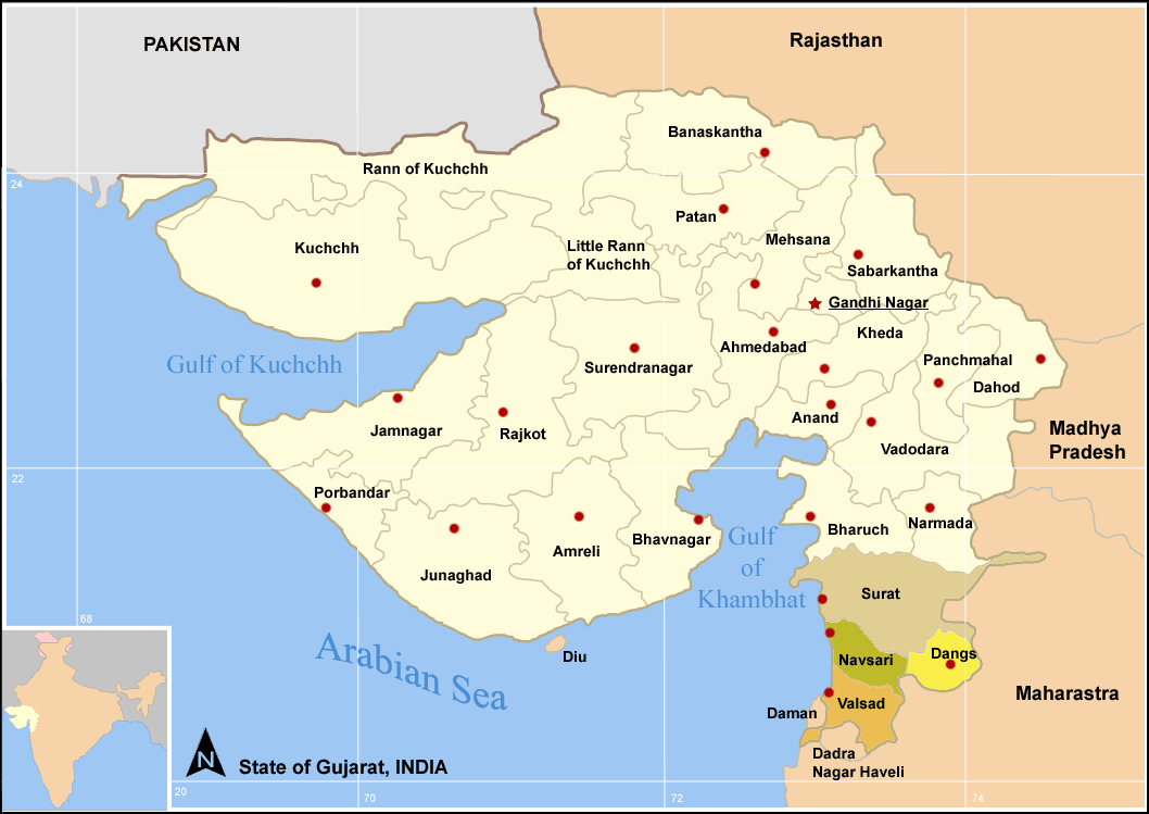
Districts of South Gujarat
Surat is a district in the state of Gujarat India with Surat city as the administrative headquarters of this district. It is surrounded by Bharuch, Narmada (North), Navsari and Dang (South) districts. To the west is the Gulf of Cambay. It is the second-most advanced district in Gujarat. It had a population of 4,995,174 of which 59.97% were urban as of 2001. On 2 October 2007 Surat district was parted in to two by forming of Tapi district under the Surat district re-orgenisation act 2007.
As of 2011 it is the second most populous district of Gujarat (out of 26), after Ahmadabad.[1]
History[]
Surat has been an important trading center since ancient times. The existence of this city can be traced back to the Vedic age. Its medieval name was Suryapur. The name, Surat, was used by the Muslim rulers or it may be derived from Persian 'Bunder-e Khoobsurat' (beautiful port).
Geography[]
Climate[]
| Climate data for Surat, Gujarat (1932-1980) | |||||||||||||
|---|---|---|---|---|---|---|---|---|---|---|---|---|---|
| Month | Jan | Feb | Mar | Apr | May | Jun | Jul | Aug | Sep | Oct | Nov | Dec | Year |
| Record high °C (°F) | 37.8 (100.0) |
39.4 (102.9) |
43.3 (109.9) |
45.0 (113.0) |
45.0 (113.0) |
45.6 (114.1) |
38.9 (102.0) |
37.2 (99.0) |
38.9 (102.0) |
41.1 (106.0) |
38.9 (102.0) |
36.7 (98.1) |
45.6 (114.1) |
| Average high °C (°F) | 30.6 (87.1) |
33.3 (91.9) |
36.7 (98.1) |
39.4 (102.9) |
40.6 (105.1) |
35.0 (95.0) |
31.7 (89.1) |
31.7 (89.1) |
31.7 (89.1) |
32.8 (91.0) |
30.6 (87.1) |
29.4 (84.9) |
33.6 (92.5) |
| Average low °C (°F) | 15.6 (60.1) |
17.8 (64.0) |
21.1 (70.0) |
24.4 (75.9) |
25.0 (77.0) |
23.3 (73.9) |
22.2 (72.0) |
21.7 (71.1) |
21.7 (71.1) |
20.6 (69.1) |
17.2 (63.0) |
15.0 (59.0) |
20.5 (68.9) |
| Record low °C (°F) | 4.4 (39.9) |
5.6 (42.1) |
10.6 (51.1) |
15.0 (59.0) |
19.4 (66.9) |
21.7 (71.1) |
20.6 (69.1) |
21.1 (70.0) |
20.6 (69.1) |
14.4 (57.9) |
10.6 (51.1) |
6.7 (44.1) |
4.4 (39.9) |
| Rainfall mm (inches) | 3.0 (0.118) |
3.0 (0.118) |
2.0 (0.079) |
2.0 (0.079) |
5.0 (0.197) |
218.0 (8.583) |
442.0 (17.402) |
191.0 (7.52) |
150.0 (5.906) |
38.0 (1.496) |
8.0 (0.315) |
3.0 (0.118) |
1,065.0 (41.929) |
| Mean monthly sunshine hours | 279.0 | 282.4 | 279.0 | 300.0 | 310.0 | 210.0 | 124.0 | 93.0 | 210.0 | 279.0 | 270.0 | 279.0 | 2,915.4 |
| Source #1: Sistema de Clasificación Bioclimática Mundial [2] | |||||||||||||
| Source #2: World Climate Guide (sunshine only)[3] | |||||||||||||
Demographics[]
According to the 2011 census Surat district has a population of 6,079,231,[1] roughly equal to the nation of El Salvador[4] or the US state of Missouri.[5] This gives it a ranking of 12th in India (out of a total of 640).[1] The district has a population density of 1,376 inhabitants per square kilometre (3,560 /sq mi) .[1] Its population growth rate over the decade 2001-2011 was 42.19 %.[1] Surat has a sex ratio of 788 females for every 1000 males,[1] and a literacy rate of 86.65 %.[1]
Culture[]
Places of tourist interest in Surat are the old fort build by Muhammad- Bin- Tughlaq, the Unai hot spring, the beautiful beaches of Ubharat and Tilhat, the villages of Bardoli and Dandi where Gandhiji started Satyagraha movement and Dandi march respectively. The Vansada National Park in Surat is famous for the wild boars, leopards, tigers, panther it houses.[6]
Notable personalities[]
- Narmadashankar Dave (1833–1886) Author, poet, scholar and public speaker. Born in Surat.
- Navalram (1836–1888) Author and literary critic. Born in Surat.
- Ranjitram Mehta (1881–1917) Author. Born in Surat.
- Gunvant Shah (1937- ) Author. Born in Rander.[7]
References[]
- ^ a b c d e f g "District Census 2011". Census2011.co.in. 2011. http://www.census2011.co.in/district.php. Retrieved 2011-09-30.
- ^ "INDIA - SURAT". Centro de Investigaciones Fitosociológicas. http://www.ucm.es/info/cif/station/in-surat.htm. Retrieved 2011-09-24.
- ^ "Surat Climate Guide". World Climate Guide. http://www.worldclimateguide.co.uk/climateguides/india/surat.php. Retrieved 2011-09-24.
- ^ US Directorate of Intelligence. "Country Comparison:Population". https://www.cia.gov/library/publications/the-world-factbook/rankorder/2119rank.html. Retrieved 2011-10-01. "El Salvador 6,071,774 July 2011 est."
- ^ "2010 Resident Population Data". U. S. Census Bureau. http://2010.census.gov/2010census/data/apportionment-pop-text.php. Retrieved 2011-09-30. "Missouri 5,988,927"
- ^ http://www.censusindiamaps.net/page/India_WhizMap/IndiaMap.htm
- ^ {{Basic Information about Gunvant Shah}}
External links[]

|
Gulf of Khambhat | Bharuch district | Narmada district |
|
| Tapi district | ||||
 Surat district | ||||
| Arabian Sea | Navsari district |
| ||||||||||||||||||||||||||||||
| This page uses content from the English language Wikipedia. The original content was at Surat district. The list of authors can be seen in the page history. As with this Familypedia wiki, the content of Wikipedia is available under the Creative Commons License. |