m (wp xfer) |
m (update from Wikipedia) |
||
| (4 intermediate revisions by 3 users not shown) | |||
| Line 1: | Line 1: | ||
| − | |||
{{Navbox county-india}}<!--copy this line to other articles for this county! --> |
{{Navbox county-india}}<!--copy this line to other articles for this county! --> |
||
{{Perspective-Place article}} <!--delete this warning if the article has reached minimal family history standards --> |
{{Perspective-Place article}} <!--delete this warning if the article has reached minimal family history standards --> |
||
| + | {{Infobox settlement |
||
| ⚫ | |||
| + | | name = Sundergarh district |
||
| − | '''Sundergarh District''', also known as '''Sundargarh District''', is a {{wp|Districts of Orissa|district}} in northwestern {{wp|Orissa}} {{wp|States and territories of India|state}} in eastern {{wp|India}}. The city of {{wp|Sundergarh}} is the district headquarters. |
||
| + | | native_name = |
||
| + | | native_name_lang = |
||
| + | | other_name = |
||
| + | | nickname = |
||
| + | | settlement_type = District |
||
| + | | image_skyline = |
||
| + | | image_alt = |
||
| + | | image_caption = |
||
| + | | image_map = OrissaSundargarh.png |
||
| + | | latd = 22.116 |
||
| + | | latm = |
||
| + | | lats = |
||
| + | | latNS = N |
||
| + | | longd = 84.016 |
||
| + | | longm = |
||
| + | | longs = |
||
| + | | longEW = E |
||
| + | | coordinates_display = inline,title |
||
| + | |map_caption = Location in Odisha, India |
||
| + | | subdivision_type = Country |
||
| + | | subdivision_name = {{flag|India}} |
||
| + | | subdivision_type1 = [[States and territories of India|State]] |
||
| + | | subdivision_name1 = [[Odisha]] |
||
| + | | established_title = <!-- Established --> |
||
| + | | established_date = |
||
| + | | founder = |
||
| + | | named_for = |
||
| + | | seat_type = Headquarters |
||
| + | | seat = [[Sundargarh]] |
||
| + | | government_type = |
||
| + | | governing_body = |
||
| + | | leader_title1 = [[District collector|Collector]] |
||
| + | | leader_name1 = Smt. Shalini Pandit, [[Indian Administrative Service|IAS]] |
||
| + | | leader_title2 = Member of [[Lok Sabha]] |
||
| + | | leader_name2 = [[Hemananda Biswal]], [[Indian National Congress|INC]] |
||
| + | | unit_pref = Metric |
||
| + | | area_footnotes = |
||
| + | | area_rank = |
||
| + | | area_total_km2 = 9712 |
||
| + | | elevation_footnotes = |
||
| + | | elevation_m = |
||
| + | | population_total = 1830673 |
||
| + | | population_as_of = 2001 |
||
| + | | population_rank = |
||
| + | | population_density_km2 = 188 |
||
| + | | population_demonym = |
||
| + | | population_footnotes = |
||
| + | | demographics_type1 = Languages |
||
| + | | demographics1_title1 = Official |
||
| + | | demographics1_info1 = [[Oriya language|Oriya]], [[Sundargadi]], English |
||
| + | | timezone1 = [[Indian Standard Time|IST]] |
||
| + | | utc_offset1 = +5:30 |
||
| + | | postal_code_type = [[Postal Index Number|PIN]] |
||
| + | | postal_code = 769 xxx |
||
| + | | registration_plate = OD-16 |
||
| + | | blank1_name_sec1 = Literacy |
||
| + | | blank1_info_sec1 = 65.22% |
||
| + | | blank2_name_sec1 = [[Lok Sabha]] constituency |
||
| + | | blank2_info_sec1 = [[Sundargarh (Lok Sabha constituency)|Sundargarh]] |
||
| + | | blank4_name_sec1 = [[Odisha Legislative Assembly|Vidhan Sabha]] constituency |
||
| + | | blank4_info_sec1 = 7 {{collapsible list|title={{nbsp}}|[[Biramitrapur]]<br /> [[Bonai]]<br /> [[Raghunathpali]]<br /> [[Rajgangpur]]<br /> [[Rourkela]]<br /> [[Sundergarh]]<br /> [[Talsara]]}} |
||
| + | | blank1_name_sec2 = [[Climate of India|Climate]] |
||
| + | | blank1_info_sec2 = [[Climatic regions of India|Aw]] <small>([[Köppen climate classification|Köppen]])</small> |
||
| + | | blank2_name_sec2 = [[Precipitation (meteorology)|Precipitation]] |
||
| + | | blank2_info_sec2 = {{convert|1657.1|mm|in}} |
||
| + | | website = {{URL|www.sundergarh.nic.in}} |
||
| + | | footnotes = |
||
| + | }} |
||
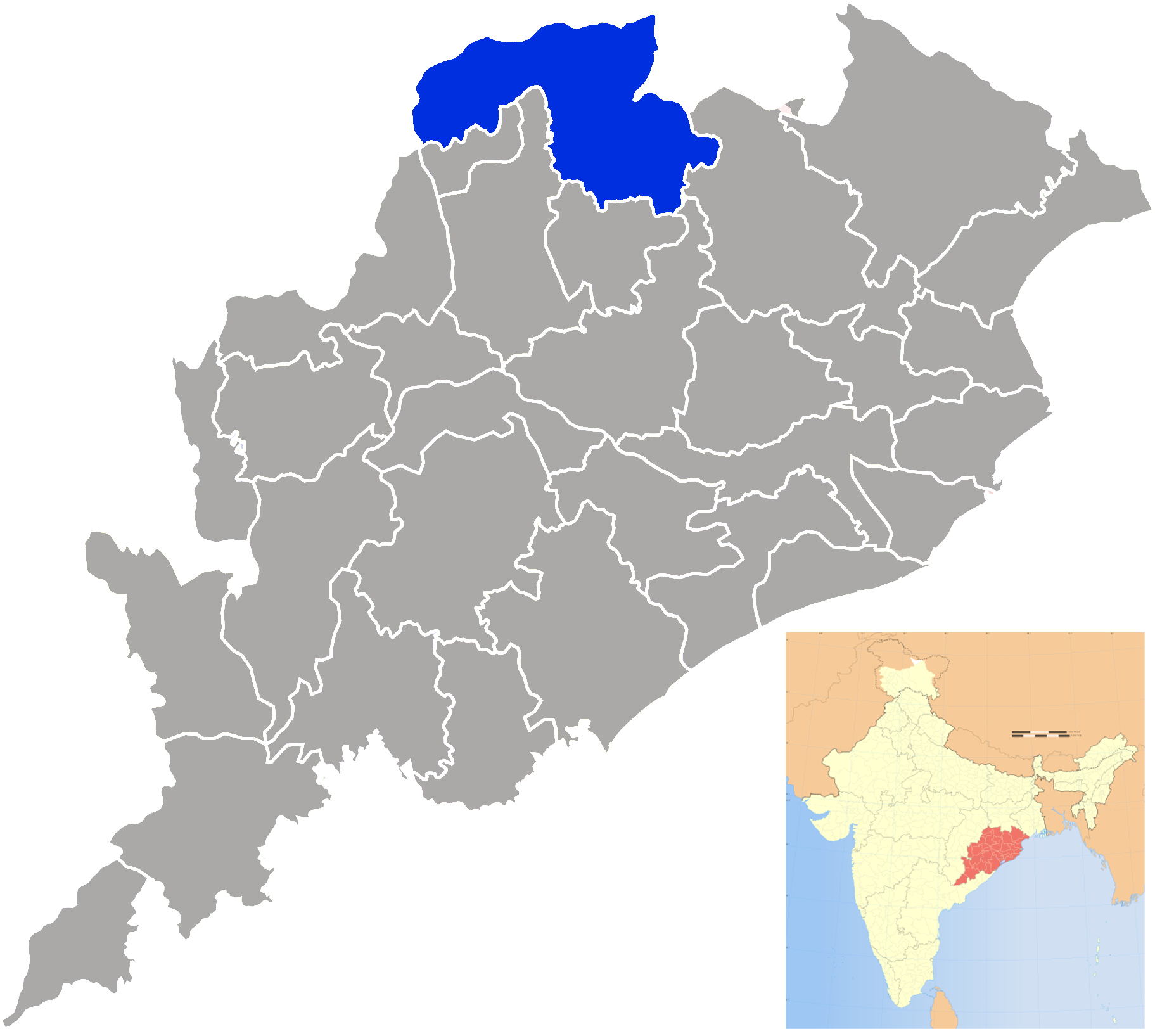
| + | '''Sundergarh District''', also spelled '''Sundargarh District''', is a [[Districts of Odisha|district]] in the northwestern part of [[Odisha]] [[States and territories of India|state]] in eastern [[India]]. Sundargarh district is bound by [[Raigarh district]] of [[Chhattisgarh]] in the west, [[Jashpur district]] of Chhattisgarh in the North-West, [[Simdega district]] of [[Jharkhand]] in the North, [[West Singhbhum district]] of Jharkhand and [[Keonjhar district]] of Odisha in the east and [[Jharsuguda district|Jharsuguda]], [[Sambalpur district|Sambalpur]] and [[Deogarh district|Deogarh]] districts of Odisha in the South. The town of [[Sundergarh]] is the district headquarters. |
||
| ⚫ | |||
| + | ==Geography== |
||
| ⚫ | |||
| + | Sundargarh district forms the North western part of Odisha state and is the Second largest district in the state accounting for 6.23% of the total area. Geographical Area of the district is 9712 km<sup>2</sup>. The district spreads from 21°36′N to 22°32′N and from 83°32′E to 85°22′E.<ref>http://sundergarh.nic.in/Introduction.htm</ref> |
||
| + | ==History== |
||
| − | Rajgangpur is an important town situated between Rourkela and sunderagrh. It has a cement plant and many small industries. Many important villages dot the route between Sundergarh and Rajgangpur. Kutra is an important village, Kutra Block has many Schools and some medical fecility. The Toppo's are the main inhabitants of this village. |
||
| + | Two princely States of [[Gangpur]] and Bonaigarh constitute the present district of Sundargarh, consequent upon merger of the princely States in 1 January 1948. It is understood that, in ancient times, this district was under the rulers of South Kosala. However, divergent views are available regarding the origin of the ruling family. Bonaigarh was known as Bonai Mandala and was ruled by Mayura dynasty as a feudetory of Bhoumakara dynasty of Utkala. The present royal family of Gangpur belongs to the Parmar dynasty and Bonaigarh belongs to Kadamba dynasty. These ex-states were under the suzerainty of Sambalpur which formed part of the dominion of the Maratha Rajas of Nagpur. They were ceded to the British Government in 1803 by the Maratha Chief Raghuji Bhonsla of Nagpur under the treaty of Deogaon(near Rourkela). But they were restored to him by special engagement in 1806. They were finally ceded in 1826. In 1905, these two princly states were transferred from the control of the commissioner of Chhotanagur to that of Odisha Division and a separate Political Agent was appointed. |
||
| + | The district is currently a part of the [[Red Corridor]].<ref>{{cite web|url=http://intellibriefs.blogspot.com/2009/12/naxal-menace-83-districts-under.html |title=83 districts under the Security Related Expenditure Scheme |publisher=IntelliBriefs |date= 11 December 2009 |accessdate=17 September 2011}}</ref> |
||
| − | Along with that there is another place known as Bonai |
||
| + | |||
| + | ==Demographics== |
||
| + | According to the [[2011 census of India|2011 census]] Sundergarh district has a [[Demographics of India|population]] of 2,080,664,<ref name=districtcensus>{{cite web | url = http://www.census2011.co.in/district.php | title = District Census 2011 | accessdate =30 September 2011 |year=2011 | publisher = Census2011.co.in}}</ref> roughly equal to the nation of [[Republic of Macedonia|Macedonia]]<ref name="cia">{{cite web | author = US Directorate of Intelligence | title = Country Comparison:Population | url = https://www.cia.gov/library/publications/the-world-factbook/rankorder/2119rank.html | accessdate =1 October 2011 | quote = |
||
| + | Macedonia |
||
| + | 2,077,328 |
||
| + | July 2011 est. |
||
| + | }}</ref> or the US state of [[New Mexico]].<ref>{{cite web|url=http://2010.census.gov/2010census/data/apportionment-pop-text.php|title=2010 Resident Population Data|publisher=U.S. Census Bureau|accessdate=30 September 2011| quote =New Mexico – 2,059,179 }}</ref> This gives it a ranking of 221st in India (out of a total of [[Districts of India|640]]).<ref name=districtcensus/> The district has a population density of {{convert| 214 |PD/sqkm|PD/sqmi}} .<ref name=districtcensus/> Its [[Family planning in India|population growth rate]] over the decade 2001–2011 was 13.66%.<ref name=districtcensus/> Sundargarh has a [[sex ratio]] of 971 [[Women in India|females]] for every 1000 males,<ref name=districtcensus/> and a [[Literacy in India|literacy rate]] of 74.13%.<ref name=districtcensus/> |
||
| + | |||
| ⚫ | The Tribals are a major part of the population of this district. According to Census of India report, percentage of tribal population of this district was 50.19 in the 2001 census. The malaria infection of this district is three times the national average. Many children die due to apathy of government medical officials. |
||
| + | * Kisan tribe |
||
| + | |||
| + | [[Kisan Tribe]] are the major inhabitants of this district along with Oram, Gond etc. They are Farmers and Food gatherers by profession. They are famous for their Singing and Dancing along with their hospitality. They speak the kisan language along with Sadri, Sambalpuri, Oriya, Hindi and English. Kutra is a very well known Kisan Village. |
||
| + | |||
| + | Kutra is a modern village situated on the State Highway between Rajgangpur and Sundergarh. It is the Block Head Quarters under Sundergarh District. It has Police Station, Fire Station, Hospital and Schools. '''Kutra Commercial Complex''' is a major identification at Kutra Bus Stand. The [[Toppo]]'s are the main residents of this village. The Tribals are the major community in this area. The Tribals are famous for their Songs and Dance along with their Hospitality. Bus is the main source of Transport and the nearest Train Station is at Rajgangpur. |
||
| + | |||
| + | The main language spoken in this region is [[Oriya language|Oriya]] which is known as '''Sundargadia Oriya''' with a variation to other major dialects of Oriya spoken in Western part of Odisha. |
||
| + | People of [[Agariya people|Agariya]] community speak [[Agariya language]], this language is a mix of Oriya and Hindi language. |
||
| + | In village areas that borders [[Jharsuguda district]] of Odisha and [[Raigarh district]] of [[Chhattisgarh]], the main language is [[Agariya language|Agariya]], as most of the total population is [[Agariya people|Agariya]]. |
||
| + | As Sundargarh is a tribal dominated district [[Mundari language|Mundari]], [[Kurukh language|Kurukh]], [[Ho language|Ho]], [[Kharia language|Kharia]], [[Santali language|Santali]] languages are spoken as mother tongue by the concerned tribal people. Santali is written in [[Ol Chiki script]]. |
||
| + | [[Sadri language]] is the lingua franca among tribal people of this district. |
||
| + | [[Hindi]] is understood and spoken by people of the district due to its close proximity with [[Jharkhand]] & [[Chhattisgarh]]. |
||
| + | Due to cosmopolitan character, people of [[Rourkela]] use Standard Oriya or Standard Hindi as medium of communication. |
||
| + | However English and [[Oriya language|Oriya]] languages are used for all official purpose. |
||
| + | |||
| + | ==Culture== |
||
| + | [[Nuakhai]] is one of the most important festivals of this district. Both Hindus and Christians celebrate "Nuakhai". |
||
| + | |||
| + | Karma is also celebrated by both Hindus and Christians. |
||
| + | |||
| + | [[Rath Yatra]] of Lord Jagannath is celebrated by non tribal people, in places having Jagannath temple. |
||
| + | * Ramnavami Festival |
||
| + | |||
| + | Bargaon in Sundargarh district of Odisha is famous for ”Ramnavami Yatra” and “Nama Sankirtana”. The place in Bargaon where the festival and cultural programs are performed is known as “Deva Mandapa”. The Deva Mandapa is surrounded by “Lord Jagannath Temple”, “Sri Hanuman Temple” and a “Dharma Sala” in three sides and the other side is a wide road connecting to the streets of Bargaon-Basti. |
||
| + | |||
| + | The theme of Ramnavami Yatra is the ‘Ramlila’. Performers of the village enact the entire story of Ramayana in open\multiple stages. The whole village is involved in facilitating and welcoming the visitors of that region. Thousands of visitors visit Bargaon during Ramnavami. Ramlila is performed at night, so security and other facilities are provided by local volunteers. |
||
| + | |||
| + | Rajgangpur is also famous for its Ramnavami Festival. |
||
| + | * Nama Sankirtana |
||
| + | |||
| + | "Nama Sankirtana" is a form of worshiping Lord Krishna and Lord Rama as per Oriya Vashnavite philosophy in a gathering. The mantra “Hare Rama, Hare Rama, Rama Rama, Hare Hare. Hare Krushna, Hare Krushna, Krushna Krushna, Hare Hare” is enchanted by the worshippers for number of times till Purnahuti (closing ceremony). It is commemorate for 1, 3, 9, 21, 56, 156 days. The highest was 156 days Nama Sankirtana in Bargaon. |
||
| + | |||
| + | ==Economy== |
||
| + | Sundargarh district does have big industries at Rourkela, Rajgangpur and Kansbahal. |
||
| + | * Rourkela |
||
| ⚫ | |||
| + | * Rajgangpur |
||
| + | Rajgangpur is an important town situated between Rourkela and Sundergarh. It has a cement plant (OCL India Limited) and many small industries and Taran Textiles. |
||
| + | * Kansbahal |
||
| + | A fabrication plant (L&T) exists at Kansbahal. |
||
| + | |||
| + | Sundargarh is going to have 2 [[umpp]],<ref>http://www.projectstoday.com/News/NewsDetails.aspx?smid=24&nid=25095</ref> one at [[Darlipali]] ([[NTPC Limited|NTPC]]) another one at [[Bhedabahal]]. Along with that there is another place known as Bonai. |
||
| + | |||
| + | In 2006 the [[Ministry of Panchayati Raj]] named Sundergarh one of the country's 250 [[Poverty in India|most backward districts]] (out of a total of [[Districts of India|640]]).<ref name=brgf/> It is one of the 19 districts in Odisha currently receiving funds from the Backward Regions Grant Fund Programme (BRGF).<ref name=brgf>{{cite web|author=Ministry of Panchayati Raj|date=8 September 2009|title=A Note on the Backward Regions Grant Fund Programme|publisher=National Institute of Rural Development|url=http://www.nird.org.in/brgf/doc/brgf_BackgroundNote.pdf|accessdate=27 September 2011}}</ref> |
||
| + | |||
| + | ==References== |
||
| + | {{reflist|colwidth=30em}} |
||
==External links== |
==External links== |
||
| + | * [http://wikimapia.org/#lat=22.2292921&lon=84.4570327&z=18&l=0&m=a&v=2 wikimapia coord] |
||
| − | *[http://sundergarh.nic.in/ Sundergarh District website] |
||
| − | * |
+ | * {{official website|http://sundergarh.nic.in/}} |
| + | |||
| + | {{Geographic location |
||
| + | |Centre = Sundergarh district |
||
| + | |North = [[Simdega district]], Jharkhand |
||
| + | |Northeast = [[West Singhbhum district]], Jharkhand |
||
| + | |East = |
||
| + | |Southeast = [[Kendujhar district]] <br> [[Anugul district]] |
||
| + | |South = [[Debagarh district]] |
||
| + | |Southwest = [[Jharsuguda district]] <br> [[Sambalpur district]] |
||
| + | |West = [[Raigarh district]], Chhattisgarh |
||
| + | |Northwest = [[Jashpur district]], Chhattisgarh |
||
| + | }} |
||
| − | {{ |
+ | {{Sundergarh district}} |
| + | {{Western Odisha}} |
||
| ⚫ | |||
| + | {{Odisha}} |
||
| + | {{Mahanadi Basin}} |
||
| ⚫ | |||
| − | {{Orissa-geo-stub}} |
||
| + | {{DEFAULTSORT:Sundergarh District}} |
||
| + | [[Category:Sundergarh district| ]] |
||
| ⚫ | |||
| − | + | {{usedwp|Sundergarh district}} |
|
Latest revision as of 00:28, 26 February 2013
| ||||||||||||||
| Sundergarh district | |
|---|---|
| — District — | |
 |
|
| Coordinates: Coordinates: | |
| Country | |
| State | Odisha |
| Headquarters | Sundargarh |
| Government | |
| • Collector | Smt. Shalini Pandit, IAS |
| • Member of Lok Sabha | Hemananda Biswal, INC |
| Area | |
| • Total | 9,712 km2 (3,750 sq mi) |
| Population (2001) | |
| • Total | 1,830,673 |
| • Density | 188/km2 (490/sq mi) |
| Languages | |
| • Official | Oriya, Sundargadi, English |
| Time zone | IST (UTC+5:30) |
| PIN | 769 xxx |
| Vehicle registration | OD-16 |
| Literacy | 65.22% |
| Lok Sabha constituency | Sundargarh |
| Vidhan Sabha constituency | 7 Biramitrapur
Bonai Raghunathpali Rajgangpur Rourkela Sundergarh Talsara |
| Climate | Aw (Köppen) |
| Precipitation | 1,657.1 millimetres (65.24 in) |
| Website | sundergarh.nic.in |
Sundergarh District, also spelled Sundargarh District, is a district in the northwestern part of Odisha state in eastern India. Sundargarh district is bound by Raigarh district of Chhattisgarh in the west, Jashpur district of Chhattisgarh in the North-West, Simdega district of Jharkhand in the North, West Singhbhum district of Jharkhand and Keonjhar district of Odisha in the east and Jharsuguda, Sambalpur and Deogarh districts of Odisha in the South. The town of Sundergarh is the district headquarters.
Geography[]
Sundargarh district forms the North western part of Odisha state and is the Second largest district in the state accounting for 6.23% of the total area. Geographical Area of the district is 9712 km2. The district spreads from 21°36′N to 22°32′N and from 83°32′E to 85°22′E.[1]
History[]
Two princely States of Gangpur and Bonaigarh constitute the present district of Sundargarh, consequent upon merger of the princely States in 1 January 1948. It is understood that, in ancient times, this district was under the rulers of South Kosala. However, divergent views are available regarding the origin of the ruling family. Bonaigarh was known as Bonai Mandala and was ruled by Mayura dynasty as a feudetory of Bhoumakara dynasty of Utkala. The present royal family of Gangpur belongs to the Parmar dynasty and Bonaigarh belongs to Kadamba dynasty. These ex-states were under the suzerainty of Sambalpur which formed part of the dominion of the Maratha Rajas of Nagpur. They were ceded to the British Government in 1803 by the Maratha Chief Raghuji Bhonsla of Nagpur under the treaty of Deogaon(near Rourkela). But they were restored to him by special engagement in 1806. They were finally ceded in 1826. In 1905, these two princly states were transferred from the control of the commissioner of Chhotanagur to that of Odisha Division and a separate Political Agent was appointed.
The district is currently a part of the Red Corridor.[2]
Demographics[]
According to the 2011 census Sundergarh district has a population of 2,080,664,[3] roughly equal to the nation of Macedonia[4] or the US state of New Mexico.[5] This gives it a ranking of 221st in India (out of a total of 640).[3] The district has a population density of 214 inhabitants per square kilometre (550 /sq mi) .[3] Its population growth rate over the decade 2001–2011 was 13.66%.[3] Sundargarh has a sex ratio of 971 females for every 1000 males,[3] and a literacy rate of 74.13%.[3]
The Tribals are a major part of the population of this district. According to Census of India report, percentage of tribal population of this district was 50.19 in the 2001 census. The malaria infection of this district is three times the national average. Many children die due to apathy of government medical officials.
- Kisan tribe
Kisan Tribe are the major inhabitants of this district along with Oram, Gond etc. They are Farmers and Food gatherers by profession. They are famous for their Singing and Dancing along with their hospitality. They speak the kisan language along with Sadri, Sambalpuri, Oriya, Hindi and English. Kutra is a very well known Kisan Village.
Kutra is a modern village situated on the State Highway between Rajgangpur and Sundergarh. It is the Block Head Quarters under Sundergarh District. It has Police Station, Fire Station, Hospital and Schools. Kutra Commercial Complex is a major identification at Kutra Bus Stand. The Toppo's are the main residents of this village. The Tribals are the major community in this area. The Tribals are famous for their Songs and Dance along with their Hospitality. Bus is the main source of Transport and the nearest Train Station is at Rajgangpur.
The main language spoken in this region is Oriya which is known as Sundargadia Oriya with a variation to other major dialects of Oriya spoken in Western part of Odisha. People of Agariya community speak Agariya language, this language is a mix of Oriya and Hindi language. In village areas that borders Jharsuguda district of Odisha and Raigarh district of Chhattisgarh, the main language is Agariya, as most of the total population is Agariya. As Sundargarh is a tribal dominated district Mundari, Kurukh, Ho, Kharia, Santali languages are spoken as mother tongue by the concerned tribal people. Santali is written in Ol Chiki script. Sadri language is the lingua franca among tribal people of this district. Hindi is understood and spoken by people of the district due to its close proximity with Jharkhand & Chhattisgarh. Due to cosmopolitan character, people of Rourkela use Standard Oriya or Standard Hindi as medium of communication. However English and Oriya languages are used for all official purpose.
Culture[]
Nuakhai is one of the most important festivals of this district. Both Hindus and Christians celebrate "Nuakhai".
Karma is also celebrated by both Hindus and Christians.
Rath Yatra of Lord Jagannath is celebrated by non tribal people, in places having Jagannath temple.
- Ramnavami Festival
Bargaon in Sundargarh district of Odisha is famous for ”Ramnavami Yatra” and “Nama Sankirtana”. The place in Bargaon where the festival and cultural programs are performed is known as “Deva Mandapa”. The Deva Mandapa is surrounded by “Lord Jagannath Temple”, “Sri Hanuman Temple” and a “Dharma Sala” in three sides and the other side is a wide road connecting to the streets of Bargaon-Basti.
The theme of Ramnavami Yatra is the ‘Ramlila’. Performers of the village enact the entire story of Ramayana in open\multiple stages. The whole village is involved in facilitating and welcoming the visitors of that region. Thousands of visitors visit Bargaon during Ramnavami. Ramlila is performed at night, so security and other facilities are provided by local volunteers.
Rajgangpur is also famous for its Ramnavami Festival.
- Nama Sankirtana
"Nama Sankirtana" is a form of worshiping Lord Krishna and Lord Rama as per Oriya Vashnavite philosophy in a gathering. The mantra “Hare Rama, Hare Rama, Rama Rama, Hare Hare. Hare Krushna, Hare Krushna, Krushna Krushna, Hare Hare” is enchanted by the worshippers for number of times till Purnahuti (closing ceremony). It is commemorate for 1, 3, 9, 21, 56, 156 days. The highest was 156 days Nama Sankirtana in Bargaon.
Economy[]
Sundargarh district does have big industries at Rourkela, Rajgangpur and Kansbahal.
- Rourkela
The Rourkela Steel Plant at Rourkela in this district is the first government sector Steel plant built with foreign (German) collaboration and was the first in India to use LD oxygen technology.
- Rajgangpur
Rajgangpur is an important town situated between Rourkela and Sundergarh. It has a cement plant (OCL India Limited) and many small industries and Taran Textiles.
- Kansbahal
A fabrication plant (L&T) exists at Kansbahal.
Sundargarh is going to have 2 umpp,[6] one at Darlipali (NTPC) another one at Bhedabahal. Along with that there is another place known as Bonai.
In 2006 the Ministry of Panchayati Raj named Sundergarh one of the country's 250 most backward districts (out of a total of 640).[7] It is one of the 19 districts in Odisha currently receiving funds from the Backward Regions Grant Fund Programme (BRGF).[7]
References[]
- ^ http://sundergarh.nic.in/Introduction.htm
- ^ "83 districts under the Security Related Expenditure Scheme". IntelliBriefs. 11 December 2009. http://intellibriefs.blogspot.com/2009/12/naxal-menace-83-districts-under.html. Retrieved 17 September 2011.
- ^ a b c d e f "District Census 2011". Census2011.co.in. 2011. http://www.census2011.co.in/district.php. Retrieved 30 September 2011.
- ^ US Directorate of Intelligence. "Country Comparison:Population". https://www.cia.gov/library/publications/the-world-factbook/rankorder/2119rank.html. Retrieved 1 October 2011. "Macedonia 2,077,328 July 2011 est."
- ^ "2010 Resident Population Data". U.S. Census Bureau. http://2010.census.gov/2010census/data/apportionment-pop-text.php. Retrieved 30 September 2011. "New Mexico – 2,059,179"
- ^ http://www.projectstoday.com/News/NewsDetails.aspx?smid=24&nid=25095
- ^ a b Ministry of Panchayati Raj (8 September 2009). "A Note on the Backward Regions Grant Fund Programme". National Institute of Rural Development. http://www.nird.org.in/brgf/doc/brgf_BackgroundNote.pdf. Retrieved 27 September 2011.
External links[]

|
Jashpur district, Chhattisgarh | Simdega district, Jharkhand | West Singhbhum district, Jharkhand |
|
| Raigarh district, Chhattisgarh | ||||
 Sundergarh district | ||||
| Jharsuguda district Sambalpur district |
Debagarh district | Kendujhar district Anugul district |
Template:Sundergarh district Template:Western Odisha
| |||||||||||||||||||||||||||
| |||||||||||||||||||||||||||||||||||||||||||
| This page uses content from the English language Wikipedia. The original content was at Sundergarh district. The list of authors can be seen in the page history. As with this Familypedia wiki, the content of Wikipedia is available under the Creative Commons License. |