| Main | Births etc |
|---|
| Stratford | |
|---|---|
| — Minor urban area Territorial authority — |
|
 |
|
 <div style="position: absolute; top: Expression error: Missing operand for *.%; left: -1219.1%; height: 0; width: 0; margin: 0; padding: 0;">
Stratford |
|
| Country | |
| Region | Taranaki |
| Territorial authority | Stratford District |
| Government | |
| • Mayor | Neil Volzke |
| • Deputy Mayor | Alan Jamieson |
| Area | |
| • Urban | 8.54 km2 (3.30 sq mi) |
| • District | 2,163.42 km2 (835.30 sq mi) |
| Population (June 2012 estimate)[1] | |
| • Urban | 5,580 |
| • Urban density | 650/km2 (1,700/sq mi) |
| • District | 9,220 |
| • District Density | 4.3000000000000/km2 (11/sq mi) |
| Postcode | 4332 |
| Area code(s) | 06 |
Stratford (Māori: Whakaahurangi) is the only town in Stratford District, and the seat of the Taranaki Region, in New Zealand's North Island. It lies beneath the eastern slopes of Mount Taranaki/Egmont, approximately halfway between New Plymouth and Hawera, near the geographic centre of the Taranaki Region. The town has a population of 5,580, making it the 47th largest urban area in New Zealand, and the fourth largest in Taranaki (behind New Plymouth, Hawera and Waitara).
The Stratford District has a population of 9,220, and a land area of 2,163.35 km², which is divided between the Manawatu-Wanganui Region (including the settlements of Whangamomona, Marco and Tahora, 31.87% of its land area) and the Taranaki Region (68.13% of its land area).
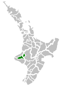
Geography[]
Location of the Stratford District
Road and rail[]
Stratford is at the junction of State Highway 3 and State Highway 43.
On State Highway 3 New Plymouth is 39 km north, Inglewood 21 km north, Eltham 11 km south and Hawera 30 km south.
On State Highway 43 Taumarunui is 146 km to the east. This road is known as "The Forgotten World Highway", due the scarcity of settlement along the road in contrast to its earlier history. A sign reads "No Petrol for 140 km".
Stratford railway station is the junction of the Marton–New Plymouth and Stratford–Okahukura lines.
Physical geography[]

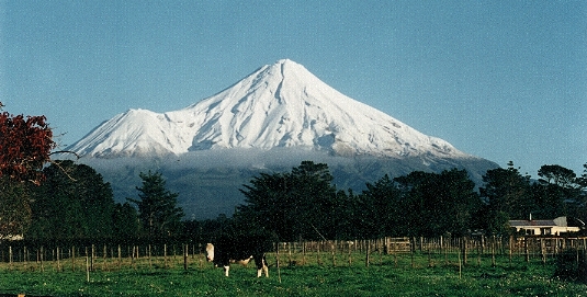
Stratford's view of Mount Taranaki (facing west), with Fanthams Peak to the left of the main peak. Stratford is a service town for the many dairy farms of Taranaki.
The Stratford District takes in about one quarter of the Taranaki Region, and includes four major geological features: the Taranaki volcanic cone, its associated ring plain, the Patea River catchment, and the eastern hill country.
Taranaki Volcanic Cone[]
The south-eastern face of Mount Taranaki is in the Stratford district, the north-westernmost point of the district being the 2518 m high peak. From the peak the boundaries run almost due east and due south.
Pembroke Road winds up the mountain slope from Stratford to a carpark and lookout at "The Plateau", at 1172 m. Manganui skifield is a short hike from the carpark, across the Manganui Gorge.
On the south-eastern face of the mountain, Manaia Road gives access to Dawson Falls and the Konini Lodge, at 890 m altitude. The natural Wilkies Pools are a short hike above the lodge.
Taranaki Volcanic Ring Plain[]
The Taranaki volcanic ring plain provides a steady contour with a subtle gradient, upon which Stratford and its environs have been settled. The easy gradient and rich volcanic soils and the high level of rainfall provide high quality pasture and agricultural land. Within this area the ring plain is drained by three river catchments: the Manganui River catchment to the north, the Waingongoro River catchment to the south, and the dominant Patea River catchment.
Patea River[]
The headwaters of the Patea River are on the eastern face of Mount Taranaki, above Stratford. From there the river flows eastwards, its upper catchment taking in a narrow area of land between the Manganui River catchment to the north and the Waingongoro River catchment to the south.
Stratford is on the banks of the Patea River, at the junction of the Patea River and Paetahi Stream, approximately 15 km east of the headwaters. Due to the narrow width of the catchment, the southern boundary of the town is on the Patea/Waingongoro divide, while 4 km to the north Midhirst is on the Patea/Manganui divide.
Beyond Stratford the catchment widens significantly to include a number of ancient swamps, including Ngaere and Toko, and also the Kahouri and Piakau ring plain streams. The river then takes in the expansive eastern hill country catchments of the Toko, Makuri, Mangaehu, Mangaotuku, Puniwhakau and Makahu Streams, before winding its way southwards through the hills of the South Taranaki district, to its mouth at Patea.
Eastern hill country[]
Beyond Stratford the district extends approximately 45 km to the east, between the Waitara River to the north and the Matemateaonga Ranges to the south, with the Whanganui River and Heao Stream constituting much of the district's eastern boundary. This area is dominated by steep sandstone, greywacke and mudstone hills and winding valleys. Much of the steep and isolated hill country is in native or exotic forestry. The remainder of the district is in sheep and/or beef pastoral farming.
Much of the eastern hill country falls within the catchment of the Patea River and its tributaries. However, to the north the district takes in Waitara River and its tributaries, including the Makara, Makino, Matau, Mangapapa and Mangaowata catchments. At its northernmost point the district also includes the Mt Damper Stream and its associated swamp and falls, which feed into the Tongaporutu River.
In the east the district takes in the Whangamomona River catchment, and also most of the Tangarakau River catchment, both of which feed into the Whanganui River. This area is separated from the west by the densely forested Whangamomona Saddle, making it an isolated and distinctive part of the district, and the area once had its own county council.
To the south-east the district also takes in the upper reaches of the Waitotara River catchment, within the Matemateaonga Ranges and the Waitotara Conservation Area.
Surrounding settlements[]
Stratford is surrounded by a number of small villages and settlements. To the north on State Highway 3 are Midhirst and beyond that Waipuku, and to the south is the locality of Ngaere. Cardiff, Mahoe, Rowan and Pembroke are beneath the mountain to the west, and Wharehuia, Tuna, Te Popo and Kupe are to the north-east.
To the east, along State Highway 43 and the Stratford-Okahukura railway, lie settlements that in their heyday were bustling villages. Toko and the renowned Whangamomona have retained their character as villages, while the settlements of Douglas, Strathmore, Huiakama, Te Wera, Pohokura, Marco, Kohuratahi and Tahora now consist of no more than a few houses. Along roads off State Highway 3 are a number of other settlements, some of which were also once bustling villages. Huiroa, Kiore, Matau and Mt. Damper are to the north and west of the highway, and Huinga, Tututawa, Puniwhakau, Makahu, Aotuhia and Tangarakau are to the south and east.
National parks[]
Stratford is the gateway to two National Parks - Egmont National Park to the west, and Whanganui National Park to the east (via Kohi Saddle, Aotuhia).
Population[]
Stratford is a rural service centre, serving the agricultural economy of its wider hinterland.
The population of the district peaked in 1961 at 11,300, and until the end of the century the town has fluctuated between 5229 (2001) and 5664 (1996).
The 21st century has seen significant economic growth and some associated population growth in the town. In the 2013 census the district population was 8988,[2] with 5466 in the township[3] and 3522 in the surrounding rural area. The 2006 census was the first time that the town had recorded population growth since the 1991 census.
Economy[]
The Egmont Ring Plain provides steady contours and fertile volcanic soils which, together with the high level of rainfall, make for some of the best dairy country in New Zealand. The district is predominantly dairying (57,300 dairy cattle), while the rolling to steep eastern hill country supports dry stock farming and forestry (42,000 beef cattle; 281,300 sheep).
The energy and tourism industries are both of growing significance to the Stratford District. The Stratford Power Station is located 3 km east of the town.
History and culture[]
Whakaahurangi[]
The Māori name for Stratford is Whakaahurangi, meaning face to the sky. The name is taken from a story of a Patea chieftainess named Ruapu-tahanga who, returning from a visit to Kawhia, camped overnight near the location of the current town. Being a clear night, Ruaputahanga lay contemplating the stars when slumber overtook her. Withdrawing in respect, her followers observed that their chieftainess slept "with her face to the sky". The site continued to be used as a camping place for Māori along what became known as the Whakaahurangi track, linking the south Taranaki tribes to those in north Taranaki, and further north to Kawhia. Each traveling party would recollect the story of Ruapu-tahanga sleeping with her face to the sky.[4] The name is fitting, given the exposure of the area to a broad horizon on the face of the mountain’s ring plain.
Surveying[]
There is no record of Māori settlement in the vicinity of Stratford. Before British settlement the area was covered in dense forest and swamp. The Vogel schemes of the 1870s provided the necessary impetus to lead to the construction of a railway line south of New Plymouth, and the creation of road access at the same time, to open up access to the rich soils under the mountain.
In 1876, Taranaki Waste Lands Board assistant surveyor Edwin Stanley Brookes, Jnr. cut a meridian line from Waitara to the site of Stratford, and oversaw the subdivision of a block between the Manganui River and the Patea River. The surveying of a new site for a town on the banks of the Patea River was authorised on 11 June 1877, and the northern half of the town (above the Patea River) was laid out by William Skinner in July. More lots were laid out by Peter Cheal in 1879, and in 1880 Skinner was directed to survey the southern half of the town.
Naming[]

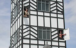
Stratford clock tower "glockenspiel"
On 3 December 1877, the name Stratford-upon-Patea was adopted, on the motion of William Crompton of the Taranaki Waste Lands Board. The supposed similarity of the Patea River to the River Avon in England led to the adoption of this name, and Crompton was known to have a literary turn of mind. There was a trend at the time to name towns after the birthplace of prominent British men. The William Shakespeare 'connection' led to the naming of 67 streets after Shakespearian characters from 27 of his plays.
Today New Zealand's only glockenspiel clock tower plays the balcony scene from Romeo and Juliet three times a day. The spoken words are provided via external loudspeakers - there is no carillon (multiple bells) as would be more typical for glockenspiels in towers.
Settlement and growth[]
Stratford was formally classified as a town in June 1878, and on 31 August 1878 an auction of 455 sections saw the first sections sold. By 1881 the population was 97, comprising 56 males and 41 females, with 22 houses. By 1891 this had grown to a population of 342 and by 1896 1,256. This growth continued steadily until the mid-late 20th century, and has since fluctuated between 5229 (2001) and 5664 (1996), numbering 5,337 at the last census.
Local government[]
Stratford District Council[]
Stratford District Council is one of 74 territorial local authorities in New Zealand. It is one of three territorial authorities in the Taranaki region, alongside New Plymouth District Council and South Taranaki District Council.
The council is led by Mayor Neil Volzke and consists of the following members:
| Councillor | Ward |
|---|---|
| John Sandford | Urban |
| Alan Jamieson | Urban |
| Viv Lett | Urban |
| Kelvin Squire | Urban |
| Suzanne Pugh | Urban |
| Robin Vickers | Rural |
| Roger Hignett | Rural |
| John Campbell | Rural |
| Rob Thomson | Rural |
History[]
The first Stratford Town Board was formed in 1882. The Stratford County Council was formed in 1890, and the Stratford Borough Council was formed on 22 July 1898. In the same year, Stratford became the third town in New Zealand to have electric street lighting, on the initiative of inventor and entrepreneur Alexander Walker Reid.[5] The county and borough councils amalgamated on 1 April 1989 to form the Stratford District Council, which was reconstituted on 1 November 1989 as part of the nationwide restructure in local government.
Past mayors, chairmen, clerks and CEOs[]
Stratford Town Chairmen[]
- George Newsham Curtis (1882–1885)
- Charles Stuart Curtis (1885–1890)
- Ebenezer Burgess (1890–1892, 1896–1898)
- William Loftus Tocker (1892–1894)
- J B Patton (1894–1896)
Stratford Borough mayors[]
- Harry Norman Liardet (1898–1899, 1902–1903)
- Frederick James Steuart (1900–1901)
- Reginald Brooking Tatton (1901–1902)
- Nathaniel John King (1903–1907)
- Pilcher Frederick Ralfe (1907–1908)
- George A Sangster (1908–1910)
- Jonas Masters (1910–1912)
- William Patrick Kirkwoord (1912–1915)
- Josephiah Wedgwood Boon (1915–1917)
- James Watson McMillan (1917–1929, 1933–1938)
- Percy Thomson (1929–1933, 1938–1947)
- Norman Harold Moss (1947–1957)
- George John Wedgwood Boon (1957–1971)
- Leo George Wellington Carrington (1971–1986)
- Lachlan Grant Bond (1986–1989)
Stratford County chairmen[]
- George Albert Marchant (1890–1892, 1905–1912)
- William Monkhouse (1892–1896)
- Joseph Mackay (1896–1899, 1900–1905)
- Richard Dingle (1900)
- William Hathaway (1912–1917)
- Edward Walter (1917–1925)
- Thomas Rheese Anderson (1925–1938)
- Joe C Best (1928–1946)
- Bruce Hutchen (1946–1970)
- Len C Harrison (1970–1977)
- HH Paul Cook (1977–1983)
- David Walter (1983–1989)
Stratford District Council mayors[]
- David Walter (1989–1998)
- Brian Robert Jeffares (1998–2007)
- John Edwards (2007–2009) (Died while in office)
- Neil Volzke (2009-)
Stratford Town Clerks[]
- Thomas Harry Penn (1898–1902)
- Ernest F Hemingway (1902–1911)
- Phillip Skogland (1911–1936)
- Gerald C Grace (1936–1975)
- P A Tourell (1975–1985)
- F W Bullen (1985–1989)
Stratford County Clerks[]
- William George Malone (1891–1900)
- Charles Penn (1900–1931)
- C L J Campbell (1931–1945)
- T A Jones (1945–1968)
- Ken J Little (1968–1975)
- MD Bell (1975–1977)
- Ross D Smith (1977–1989)
Stratford District Chief Executives[]
- Poiha Kemp Broughton (1989–2001)
- Wayne Allan Kimber (2001–2004)
- Michael Roy Freeman (2004–2011)
- Sue Davidson (2011-)
Schools[]
The Western Institute of Technology at Taranaki has a campus in Stratford,[6] established in 1989.[7]
There are two secondary schools in Stratford:
- Stratford High School is a coeducational secondary (years 9-13) school with a decile rating of 4 and a roll of 516.[8] The school was founded in 1897[9] and celebrated its centenary in 1997.[10]
- St Mary's Diocesan School is a state integrated Anglican girls' secondary (years 9-13) school with adecile rating of 6 and a roll of 159.[11] The school was founded in 1914 and moved ot its present site in 1917.[12] Most of the students are boarders.[13]
There are three primary schools within Stratford township:
- Stratford Primary School has a decile rating of 4 and a roll of 405.[14] The school was founded in 1882 and celebrated 125 years in 2007.[15]
- Avon School has a decile rating of 1 and a roll of 59.[16]
- St Joseph's School is a state integrated Catholic school with a decile rating of 6 and a roll of 232.[17]
All these primary schools are coeducational and accept students for years 1-8.
There are seven primary schools in the surrounding district. Recent years has seen the consolidation of a large number of schools into these seven schools:
- Midhirst School
- Ngaere School
- Pembroke School
- Toko School
- Huiakama School
- Marco School
- Makahu School
Parks and reserves[]
Stratford has a number of public parks and reserves, with names reflecting its English and Māori heritage;
- King Edward Park
- Victoria Park
- Windsor Park
- Kopuatama Cemetery
Born or lived in Stratford[]
Sportsplayers[]
- Mark "Bull" Allen (31 July 1967), All Black, TV host
- Christine Arthur (26 August 1963), New Zealand field hockey player
- Arthur Collins (1906–1988), All Black
- John Graham (1 January 1935), All Black, NZRU president, NZ cricket team manager, Auckland University Chancellor, Auckland Grammar School headmaster, businessman
- Stan Lay (1906–2003) Olympic Javelin thrower (born in New Plymouth)
- Dave Loveridge (born 22 April 1952), former All Black
- John McCullough (8 January 1936), All Black
- Lane Penn, representative rugby footballer, coach, All Black selector and NZRU President
- Mark Robinson (born 17 January 1974), former All Black
- John Edward (Ned) Shewry (1889–1962), world champion woodchopper
- Alan Smith (10 December 1942), All Black
- Jeremiah Trueman (born 19 May 1987), New Zealand national basketball representative
Literature, art and culture[]
- Sylvia Ashton-Warner (1908–1984), novelist, autobiographer and educational pioneer
- Michael Hight (1961), artist - painter
- Michele Leggott (1956), poet and literary scholar
- Dominic Sheehan, author of Finding Home, a novel that illustrates growing up in Stratford
- Greg Whyte (1958), Author
- Paula Parore, musician, contestant of 'The Voice Australia'
Medicine[]
- Dr John Daniel Bergin (17 January 1921 - 22 July 1995), Distinguished physician and neurologist, Catholic pro-life apologist
- Dr Mel Brieseman, missionary to India, Canterbury Medical Officer of Health
- Dr Graham Gordon (10 December 1927 - 29 February 2004), Surgeon, St John's officer, NZMA Council Chairman (1977–1988) and NZMA President (1990–1991)
Law, government and politics[]
- David Spence Thomson (1915–1999), Minister of Defence and Minister of Justice in the Third National Government of New Zealand
- Venn Young (1929–1993), Cabinet minister in the Muldoon National Government and homosexual rights activist
Academics[]
- Alice Copping (14 May 1906 - 21 August 1982), Senior lecturer in nutrition, Queen Elizabeth College, University of London
- Dr Alan Kirton (1933 - 2001), agricultural scientist
Other[]
- Brian Davis, (1934–1998), Archbishop of New Zealand
- Emily Stevens (3 September 1900 - 8 August 1967), wholesale florist, nurserywoman, iris hybridiser
Sister cities[]
 Stratford, Ontario, Canada
- Stratford, Connecticut, United States
- Stratford-upon-Avon, England
Notes[]
- ^ "Subnational population estimates at 30 June 2012". Statistics New Zealand. 23 October 2012. http://www.stats.govt.nz/browse_for_stats/population/estimates_and_projections/subnational-pop-estimates-tables.aspx. Retrieved 23 October 2012. Also "Infoshare; Group: Population Estimates - DPE; Table: Estimated Resident Population for Urban Areas, at 30 June (1996+) (Annual-Jun)". Statistics New Zealand. 19 December 2012. http://www.stats.govt.nz/infoshare/SelectVariables.aspx?pxID=2f5a6aa2-7aeb-4792-a34a-d5567eb8082f. Retrieved 23 October 2012.
- ^ Template:NZ Quickstats2013
- ^ The population is the sum of the statistical areas of Stratford West (Template:NZ Quickstats2013) and Stratford East (Template:NZ Quickstats2013)
- ^ Gordon, W.F., Battersby, J.H., Richards, J.B., Kennedy, W.L., and Kelly, C.S.. Carved from the Bush: Stratford 1878-1928. 1928.
- ^ Donald, Mary. "Alexander Walker Reid". Dictionary of New Zealand Biography. Ministry for Culture and Heritage. http://www.teara.govt.nz/en/biographies/2r12. Retrieved December 2011.
- ^ "Campus Maps". Western Institute of Technology. http://www.witt.ac.nz/Content/sub/100007551.aspx.
- ^ "WITT History". Western Institute of Technology. http://www.witt.ac.nz/Content/sub/100012417.aspx.
- ^ "Te Kete Ipurangi - Stratford High School (New Zealand)|Stratford High School". Ministry of Education. http://www.tki.org.nz/e/schools/display_school_info.php?school_id=179.
- ^ "Home Page". Stratford High School. http://www.stratfordhigh.school.nz/.
- ^ (10 March 1997) "Stratford High School" (– Scholar search). Education Gazette New Zealand 76 (4).
- ^ "Te Kete Ipurangi - St Mary's Diocesan School (New Zealand)|St Mary's Diocesan School". Ministry of Education. http://www.tki.org.nz/e/schools/display_school_info.php?school_id=180.
- ^ "About St.Marys". St Mary's Diocesan School. http://www.stmarysstratford.school.nz/index.php?option=com_content&task=category§ionid=15&id=26&Itemid=66.
- ^ "Welcome to St Mary's Diocesan School". St Mary's Diocesan School. http://www.stmarysstratford.school.nz/.
- ^ "Te Kete Ipurangi - Stratford School". Ministry of Education. http://www.tki.org.nz/e/schools/display_school_info.php?school_id=2244.
- ^ (5 February 2007) "Stratford Primary School" (– Scholar search). Education Gazette New Zealand 86 (1).
- ^ "Te Kete Ipurangi - Avon School". Ministry of Education. http://www.tki.org.nz/e/schools/display_school_info.php?school_id=2153.
- ^ "Te Kete Ipurangi - St Joseph's School, Stratford|St Joseph's School". Ministry of Education. http://www.tki.org.nz/e/schools/display_school_info.php?school_id=2238.
References[]
- The Stratford Inheritance by Ian Church, 1990, Heritage Press Ltd, Waikanae, New Zealand: ISBN 0-908708-17-3
- Stratford: Shakespearean Town Under the Mountain by David Walter, 2005, Dunmore Publishing, Wellington, New Zealand: ISBN 1-877399-05-1
External links[]
- Tourism Taranaki
- Stratford District Council
- Stratord Information Centre
- Stratford High School
- St Mary's Diocesan School
- Stratford in the 1966 Encyclopaedia of New Zealand
- The Stratfordian
- Stratford School website
| |||||||||||||||||||
| This page uses content from the English language Wikipedia. The original content was at Stratford, New Zealand. The list of authors can be seen in the page history. As with this Familypedia wiki, the content of Wikipedia is available under the Creative Commons License. |