m (cleanup- template wp) |
m (update from Wikipedia) |
||
| (3 intermediate revisions by 2 users not shown) | |||
| Line 1: | Line 1: | ||
| + | {{bdm}} |
||
{{Navbox county-uk}}<!--copy this line to other articles for this county! --> |
{{Navbox county-uk}}<!--copy this line to other articles for this county! --> |
||
{{Perspective-Place article}} <!--delete this warning if the article has reached minimal family history standards --> |
{{Perspective-Place article}} <!--delete this warning if the article has reached minimal family history standards --> |
||
| − | {{ |
+ | {{About|the county of Somerset in England}} |
{{Infobox England county |
{{Infobox England county |
||
| name = Somerset |
| name = Somerset |
||
| − | | image = |
+ | | image = [[File:Somnew.png|border|160px]] |
| − | | motto = |
+ | | motto = Sumorsǣte ealle <br />''(''<nowiki>'</nowiki>All The People of Somerset<nowiki>'</nowiki>'') |
| + | | map = [[File:Somerset UK locator map 2010.svg|200px|Somerset within England]] |
||
| − | | map = [[Image:EnglandSomerset.png]] |
||
| + | | alt=Map of England and Wales showing the position of Somerset, shaded in red, in the northern area of the south west peninsula. |
||
| − | | status = [[Wikipedia:Ceremonial counties of England|Ceremonial]] & (smaller) [[Wikipedia:Metropolitan and non-metropolitan counties of England|Non-metropolitan]] county |
||
| + | | status = [[Ceremonial counties of England|Ceremonial]] and (smaller) [[Metropolitan and non-metropolitan counties of England|non-metropolitan]] county |
||
| − | | origin = [[Wikipedia:Historic counties of England|Historic]] |
||
| − | | |
+ | | origin = [[Ancient counties of England|Historic]] |
| − | | |
+ | | region = [[South West England]] |
| + | | arearank = [[List of Ceremonial counties of England by Area|Ranked 7th]] |
||
| area_km2 = 4171 |
| area_km2 = 4171 |
||
| − | | adminarearank = [[ |
+ | | adminarearank = [[List of Administrative shire counties of England by Area|Ranked 12th]] |
| adminarea_km2 = 3451 |
| adminarea_km2 = 3451 |
||
| − | | adminhq = [[ |
+ | | adminhq = [[Taunton]] |
| iso = GB-SOM |
| iso = GB-SOM |
||
| ons = 40 |
| ons = 40 |
||
| nuts3 = UKK23 |
| nuts3 = UKK23 |
||
| − | | poprank = |
+ | | poprank = [[List of ceremonial counties of England by population|Ranked {{English cerem counties|RNK=Somerset}}]] |
| popestdate = {{English statistics year}} |
| popestdate = {{English statistics year}} |
||
| pop = {{English cerem counties|POP=Somerset}} |
| pop = {{English cerem counties|POP=Somerset}} |
||
| density_km2 = {{English cerem counties|DEN=Somerset}} |
| density_km2 = {{English cerem counties|DEN=Somerset}} |
||
| − | | adminpoprank = |
+ | | adminpoprank = [[List of non-metropolitan counties of England by population|Ranked {{English admin counties|RNK=Somerset}}]] |
| adminpop = {{English admin counties|POP=Somerset}} |
| adminpop = {{English admin counties|POP=Somerset}} |
||
| ethnicity = 98.5% White |
| ethnicity = 98.5% White |
||
| − | | council = [[ |
+ | | council = [[File:Somerset county coat of arms.png]] |alt=Coat of arms with a yellow shield with a red dragon supported by a red deer and bull with yellow crowns around their necks, above these are a grey coloured helmet surmounted by a white goat<br />Somerset County Council<br />http://www.somerset.gov.uk/irj/public |
| exec = {{English county control|CTY=Somerset}} |
| exec = {{English county control|CTY=Somerset}} |
||
| − | | mps = *[[ |
+ | | mps = *[[Jeremy Browne]] [[Liberal Democrats (UK)|(LD)]] |
| − | *[[ |
+ | * [[Donald Foster (politician)|Don Foster]] (LD) |
| − | *[[ |
+ | * [[Liam Fox]] [[Conservative Party (UK)|(C)]] |
| − | *[[ |
+ | * [[David Heath (politician)|David Heath]] (LD) |
| − | *[[ |
+ | * [[David Laws]] (LD) |
| + | * [[Ian Liddell-Grainger]] (C) |
||
| − | *[[Wikipedia:David Laws|David Laws]] (LD) |
||
| + | * [[Tessa Munt]] (LD) |
||
| − | *[[Wikipedia:Ian Liddell-Grainger|Ian Liddell-Grainger]] (C) |
||
| + | * [[Jacob Rees-Mogg]] (C) |
||
| − | *[[Wikipedia:Dan Norris|Dan Norris]] [[Wikipedia:Labour Party (UK)|(L)]] |
||
| − | *[[ |
+ | * [[John Penrose (politician)|John Penrose]] (C) |
| + | | subdivmap = [[File:Somerset Ceremonial Numbered2.gif]] |alt=map of the five non metropolitan districts and two unitary authorities in the ceremonial county |
||
| − | | subdivmap = [[Image:Somerset_Ceremonial_Numbered2.gif]] |
||
| − | | subdivs = #[[ |
+ | | subdivs = #[[South Somerset]] |
| − | #[[ |
+ | # [[Taunton Deane]] (Borough) |
| − | #[[ |
+ | # [[West Somerset]] |
| − | #[[ |
+ | # [[Sedgemoor]] |
| − | #[[ |
+ | # [[Mendip]] |
| − | #[[ |
+ | # [[Bath and North East Somerset]] (Unitary) |
| − | #[[ |
+ | # [[North Somerset]] (Unitary) |
}} |
}} |
||
| + | The [[Ceremonial counties of England|ceremonial]] and [[Metropolitan and non-metropolitan counties of England|non-metropolitan]] county of '''Somerset''' ({{IPAc-en|audio=En-uk-Somerset.ogg|ˈ|s|ʌ|m|ɚ|s|ɛ|t}} or {{IPAc-en|ˈ|s|ʌ|m|ɚ|s|ɨ|t}}) in [[South West England]] borders [[Bristol]] and [[Gloucestershire]] to the north, [[Wiltshire]] to the east, [[Dorset]] to the south-east, and [[Devon]] to the south-west. It is partly bounded to the north and west by the [[Bristol Channel]] and the [[estuary]] of the [[River Severn]]. Its traditional northern border is the [[River Avon (Bristol)|River Avon]], but the administrative boundary has crept southwards with the creation and expansion of the [[Bristol|City of Bristol]], and latterly the county of [[Avon (county)|Avon]] and its successor [[Unitary authority|unitary authorities]] to the north.<ref name="rajan"/> Somerset's [[county town]], [[Taunton]], is in the south. |
||
| + | Somerset is a rural county of rolling hills such as the [[Blackdown Hills]], [[Mendip Hills]], [[Quantock Hills]] and [[Exmoor|Exmoor National Park]], and large flat expanses of land including the [[Somerset Levels]]. There is evidence of human occupation from [[Paleolithic|Palaeolithic]] times, and of subsequent settlement in the [[Roman Empire|Roman]] and [[Anglo-Saxons|Anglo-Saxon]] periods. The county played a significant part in the consolidation of power and rise of [[Alfred the Great|King Alfred the Great]], and later in the [[English Civil War]] and the [[Monmouth Rebellion]]. |
||
| − | '''Somerset''' is a [[Wikipedia:Counties of England|county]] in the south-west of [[England|England]]. The [[Wikipedia:county town|county town]] is [[Wikipedia:Taunton|Taunton]]. The [[Wikipedia:Ceremonial counties of England|ceremonial county]] of Somerset borders the counties of [[Bristol|Bristol]] and [[Gloucestershire|Gloucestershire]] to the north, [[Wiltshire|Wiltshire]] to the east, [[Dorset|Dorset]] to the south-east, and [[Devon|Devon]] to the south-west. It is also partly bounded to the north and west by the coast of the [[Wikipedia:Bristol Channel|Bristol Channel]] and the [[Wikipedia:estuary|estuary]] of the [[Wikipedia:River Severn|River Severn]]. |
||
| + | Agriculture is a major business in the county. Farming of sheep and cattle, including for wool and the county's famous cheeses (most notably [[cheddar cheese|Cheddar]]), are traditional and contemporary, as is the more unusual cultivation of [[willow]] for [[basket weaving]]. Apple orchards were once plentiful, and Somerset is still known for the production of strong [[cider]]. Unemployment is lower than the national average; the largest employment sectors are retail, manufacturing, tourism, and health and social care. Population growth in the county is higher than the national average. |
||
| − | The traditional northern border of the county was the [[Wikipedia:River Avon, Bristol|River Avon]], but the administrative boundary has crept southwards, with the creation and expansion of the [[Bristol|City of Bristol]].<ref name="rajan"/> |
||
| + | == Toponymy == |
||
| − | Somerset is a rural county of rolling hills such as the [[Wikipedia:Mendip Hills|Mendip Hills]], [[Wikipedia:Quantock Hills|Quantock Hills]] and [[Wikipedia:Exmoor National Park|Exmoor National Park]], and large flat expanses of land including the [[Wikipedia:Somerset Levels|Somerset Levels]]. There is evidence of occupation from [[Wikipedia:Neolithic|Neolithic]] times, with subsequent [[Roman Empire|Roman]] and [[Wikipedia:Saxon people|Saxon]] occupation. Later the county played a significant part in the [[Wikipedia:English Civil War|English Civil War]] and [[Wikipedia:Monmouth Rebellion|Monmouth Rebellion]]. |
||
| + | The name derives from [[Old English]] ''[[Sumorsǣte]]'', which is short for ''[[Sumortūnsǣte]]'', meaning "the people living at or dependent upon [[Sumortūn]]."<ref name="watts1">{{cite book | last=Watts | first=Victor (Ed.) | title=The Cambridge Dictionary of English Place-Names | publisher=[[Cambridge University Press]] | year=2004 | isbn=0-521-36209-1}}</ref> The first known use of the name ''[[Somersæte]]'' was in 845, after the region fell to the Saxons.<ref name="EB1911">{{cite web |url=http://www.1911encyclopedia.org/Somersetshire |title=Somersetshire |accessdate=21 October 2007 |work=[[Encyclopædia Britannica Eleventh Edition|1911 Encyclopaedia Britannica]] }}</ref> |
||
| + | Sumortūn is modern [[Somerton]] and may mean "summer settlement," a [[farmstead]] occupied during the summer but abandoned in the winter.<ref name="name">{{cite web | title=Mesolithic hunters and fishermen | work=Somerset History |url=http://www.somerset.gov.uk/archives/ASH/Meshuntfish.htm|accessdate=28 May 2006}}</ref> However, Somerton is not down on the levels—lower ground, where only summer occupation was possible because of flooding—but on a hill where winter occupation would have been feasible. An alternative suggestion is that the name derives from ''Seo-mere-saetan'' meaning "settlers by the sea lakes."<ref>{{cite book |last=Whitlock |first=Ralph |title=Somerset |year=1975 |publisher=B.T. Batsford Ltd |location=London |isbn=978-0-7134-2905-3}}</ref> |
||
| + | The people of Somerset are first mentioned in the [[Anglo-Saxon Chronicle]]'s entry for AD 845, in the [[wikt:inflect|inflected]] form "Sumursætum," but the county is first mentioned in the entry for 1015 using the same name. The archaic county name ''Somersetshire'' is first mentioned in the Chronicle's entry for 878. Although "Somersetshire" had been in common use as an alternative name for the county, it went out of fashion in the late 19th century, and is no longer used. This is possibly due to the adoption of "Somerset" as the official name for the county through the establishment of the County Council in 1889. However, as with other counties not ending in "shire," this [[wikt:suffix|suffix]] was superfluous, as there was no need to differentiate between the county and a town within it. |
||
| + | The Old English name continues to be used in the [[motto]] of the county, ''Sumorsǣte ealle'', meaning "all the people of Somerset." Adopted as the motto in 1911, the phrase is taken from the [[Anglo-Saxon Chronicle]]. Somerset was a part of the [[Anglo-Saxon England|Anglo-Saxon]] kingdom of [[Wessex]], and the phrase refers to the wholehearted support the people of Somerset gave to [[King Alfred]] in his struggle to save Wessex from the [[Viking]] invaders.<ref>{{cite web |url=http://www.somerset.gov.uk/archives/ASH/Danishinvs.htm |title=The Danish Invasions |accessdate=18 October 2007 |work=Somerset County Council archives }}</ref><ref>{{cite web |url=http://asc.jebbo.co.uk/e/e-L.html |title=Manuscript E: Bodleian MS Laud 636. The Anglo-Saxon Chronicle: An Electronic Edition (Vol 5) literary edition |accessdate=21 January 2008 |work=The Anglo-Saxon Chronicle }}</ref><ref>{{cite web |url=http://www.gutenberg.org/ebooks/657 |title=The Anglo-Saxon Chronicle |accessdate=21 January 2008 |work=Project Gutenburg }}</ref> |
||
| − | Agriculture continues to be a major business in the county. Apple orchards were once plentiful, and to this day Somerset is linked to the production of strong cider. Population growth in the county is higher than the national average. Unemployment is lower than the national average, and the largest employment sectors are retail, manufacturing, leisure/tourism, and health/social care. |
||
| + | Somerset is ''Gwlad yr Haf'' in Welsh, ''Gwlas an Hav'' in Cornish and ''Bro an Hañv'' in Breton, which all mean "Country of the Summer". |
||
| − | ==History== |
||
| − | {{main|History of Somerset}} |
||
| + | Somerset settlement names are mostly Anglo-Saxon in origin, but a few hill names include [[British language|Celtic]] elements. For example, an [[Anglo-Saxon charters|Anglo-Saxon charter]] of 682 refers to Creechborough Hill as "the hill the British call ''Cructan'' and we call ''Crychbeorh''"<ref>{{cite book |url=http://books.google.com/?id=wA0lDM52m7MC&printsec=titlepage |title= Cartularium saxonicum: a collection of charters relating to Anglo-Saxon history |accessdate=21 April 2008 |work=Google Books |author1=Birch, Walter de Gray |year=1885 }}</ref> ("we" being the Anglo-Saxons). Some modern names are [[British language (Celtic)|Brythonic]] in origin, such as [[Tarnock]], while others have both Saxon and Brythonic elements, such as [[Pen Hill]].<ref>{{cite web |url=http://www.takeourword.com/TOW110/page2.html |title=A word to the wise |accessdate=22 January 2008 |work=Take our word for it }}</ref> |
||
| − | ===Toponymy=== |
||
| − | The name derives from [[Wikipedia:Old English language|Old English]] ''Sumorsǣte'', which is short for ''Sumortūnsǣte'', meaning "the people living at or dependent upon Sumortūn".<ref name="watts1">{{cite book | last=Watts | first=Victor (Ed.) | title=The Cambridge Dictionary of English Place-Names | publisher={{subst:#ifexist:Cambridge University Press|[[Cambridge University Press|]]|[[Wikipedia:Cambridge University Press|]]}} | date=2004 | id=ISBN 0-521-36209-1}}</ref> The first known use of the name ''Somersæte'' was in 845 after the region fell to the Saxons.<ref name="1911britanica">{{cite web |url=http://www.1911encyclopedia.org/Somersetshire |title=Somersetshire |accessdate=2007-10-21 |format= |work={{subst:#ifexist:Encyclopædia Britannica Eleventh Edition|[[Encyclopædia Britannica Eleventh Edition|1911 Encyclopaedia Britannica]]|[[Wikipedia:Encyclopædia Britannica Eleventh Edition|1911 Encyclopaedia Britannica]]}} }}</ref> |
||
| − | Sumortūn is modern [[Wikipedia:Somerton|Somerton]] and may mean "summer settlement", a [[Wikipedia:farmstead|farmstead]] tended during the summer but not occupied in winter.<ref name="name">{{cite web | title=Mesolithic hunters and fishermen | work=Somerset History |url=http://www.somerset.gov.uk/archives/ASH/Meshuntfish.htm|accessdate=2006-05-28}}</ref> However, Somerton is not down on the levels where only summer occupation was possible because of flooding, but on a hill where winter occupation would have been feasible. An alternative derivation is that the name came from ''Seo-mere-saetan'' meaning "settlers by the sea lakes".<ref>{{cite book |last=Whitlock |first=Ralph |authorlink= |coauthors= |title=Somerset |year=1975 |publisher=B.T. Batsford Ltd |location=London |isbn=0713429054 }}</ref> |
||
| + | == History == |
||
| − | The Old English name continues to be used in the [[motto|motto]] of the county, ''Sumorsaete ealle'', meaning "all the people of Somerset". It was adopted in 1911, taken from the [[Wikipedia:Anglo-Saxon Chronicle|Anglo-Saxon Chronicle]]. Somerset was a part of the [[Wikipedia:History of Anglo-Saxon England|Anglo-Saxon]] [[Wikipedia:kingdom of Wessex|kingdom of Wessex]], and the reference is thought to indicate the wholehearted support the people of Somerset gave to [[Wikipedia:King Alfred|King Alfred]] in his struggle to save Wessex from the [[Wikipedia:Viking|Viking]] invaders.<ref>{{cite web |url=http://www.somerset.gov.uk/archives/ASH/Danishinvs.htm |title=The Danish Invasions |accessdate=2007-10-18 |format= |work=Somerset County Council archives }}</ref> |
||
| + | {{Main|History of Somerset}} |
||
| + | The caves of the [[Mendip Hills]] were settled during the [[Palaeolithic]] period,<ref>{{cite web|title=Introduction|url=http://www1.somerset.gov.uk/archives/ASH/Palper.htm|publisher=Somerset Government|accessdate=29 December 2010}}</ref> and contain extensive archaeological sites such as those at [[Cheddar Gorge]]. Bones from [[Gough's Cave]] have been dated to 12,000 BC, and a complete skeleton, known as [[Cheddar Man]], dates from [[8th millennium BC|7150 BC]]. Examples of cave art have been found in caves such as [[Aveline's Hole]]. Some caves continued to be occupied until modern times, including [[Wookey Hole Caves|Wookey Hole]]. |
||
| − | Somerset settlement names are mostly Anglo-Saxon in origin. A few hill names include [[Wikipedia:Brythonic|Celtic]] elements, for example a charter of 682 concerning [[Wikipedia:Creechborough Hill|Creechborough Hill]] defines it as "the hill the British call ''Cructan'' and we call ''Crychbeorh''". A few modern names are Brythonic in origin, such as [[Wikipedia:Tarnock|Tarnock]], while a few others have both Saxon and Brythonic elements such as [[Wikipedia:Pen Hill|Pen Hill]].<ref>{{cite web |url=http://www.mendiphillsaonb.org.uk/publications/up_081015_autumn07_lo.pdf |title=Autumn newsletter 2007 |accessdate=2007-09-25 |format=PDF |work=Mendip Hills AONB }}</ref> |
||
| + | The [[Somerset Levels]]—specifically the [[dry point]]s such as [[Glastonbury]] and [[Brent Knoll]]— also have a long history of settlement, and are known to have been settled by [[Mesolithic]] hunters.<ref name="Dunning">{{cite book |last=Dunning |first=Robert |title=A History of Somerset |year=1983 |publisher=Phillimore & Co |location=Chichester |isbn= 0-85033-461-6 }}</ref><ref name="Mesolithic">{{cite web | title=Somerset | work=Camelot Village: Britain's Heritage and History |url=http://www.camelotintl.com/heritage/counties/england/somerset.html|accessdate=28 May 2006}}</ref> Travel in the area was helped by the construction of one of the world's oldest known engineered roadways, the [[Sweet Track]], which dates from 3807 BC or 3806 BC.{{#tag:ref|A 6,000 year-old trackway was discovered in [[Belmarsh prison]] in 2009.<ref>{{cite web|url=http://www.physorg.com/news169297178.html|title=London's earliest timber structure found during Belmarsh prison dig|last=Anon|date=12 August 2009|work=physorg.com News|publisher=PhysOrg.com|accessdate=10 July 2010}}</ref>|group=Note}}<ref>{{cite web | title = The day the Sweet Track was built | work=New Scientist, 16 June 1990 | url = http://www.newscientist.com/article/mg12617212.800-science-the-day-the-sweet-track-was-built.html | accessdate =13 November 2010 }}</ref><ref name=brunning>Brunning, Richard (2001). "The Somerset Levels." In: [[Current Archaeology]], '''Vol. XV''', (No. 4), Issue Number 172 (''Wetlands Special Issue''), (February 2001), Pp 139–143. [[ISSN|ISSN 0011-3212]].</ref> |
||
| − | ===Human occupation=== |
||
| − | The |
+ | The exact age of the [[henge monument]] at [[Stanton Drew stone circles]] is unknown, but it is believed to be [[Neolithic]].<ref>{{cite web | title=Stanton Drew Stone Circles | publisher=English Heritage | url=http://www.english-heritage.org.uk/daysout/properties/stanton-drew-circles-and-cove/history-and-research/ | accessdate=30 November 2011}}</ref> There are numerous [[Iron Age]] [[hill fort]]s, some of which, like [[Cadbury Castle, Somerset|Cadbury Castle]]<ref>{{cite web | title=Mendip Hills: An Archaeological Survey of the Area of Outstanding Natural Beauty | work=Somerset County Council Archaeological Projects | url=http://www1.somerset.gov.uk/archives/hes/downloads/HES_MendipAONB.pdf| format=PDF | accessdate=13 November 2010}}</ref> |
| + | and [[Ham Hill, Somerset|Ham Hill]], were later reoccupied in the [[Early Middle Ages]]. |
||
| − | and [[Wikipedia:Ham Hill, Somerset|Ham Hill]]. The age of the [[Wikipedia:henge monument|henge monument]] at [[Wikipedia:Stanton Drew stone circles|Stanton Drew stone circles]] is not known, but is believed to be Neolithic.<ref>{{cite web | title=Stanton Drew Stone Circles | work=English Heritage Archeometry | url=http://www.eng-h.gov.uk/archaeometry/StantonDrew/ | accessdate=2006-07-08}}</ref> |
||
| − | On the authority of the future emperor [[ |
+ | On the authority of the future emperor [[Vespasian]], as part of the ongoing expansion of the Roman presence in Britain, the [[Legio II Augusta|Second Legion Augusta]] invaded Somerset from the south-east in AD 47. The county remained part of the [[Roman Empire]] until around AD 409, when the Roman occupation of Britain came to an end.<ref name="rajan">{{cite news |first=Amal |last=Rajan |title=Around a county in 40 facts: A (very) brief history of Somerset |url=http://www.independent.co.uk/news/uk/this-britain/around-a-county-in-40-facts-a-very-brief-history-of-somerset-462828.html |work=Independent on Sunday |date= 24 August 2007 |accessdate=21 October 2007 |location=London}}</ref> |
| − | A variety of Roman remains have been found |
+ | A variety of Roman remains have been found, including [[Pagans Hill Roman Temple]] in [[Chew Stoke]],<ref name="hucker">{{cite book | author=Hucker, Ernest| year = 1997 | title = Chew Stoke Recalled in Old Photographs | publisher=Ernest Hucker | id = }}</ref> |
| − | [[ |
+ | [[Low Ham Roman Villa]] and the [[Roman Baths (Bath)|Roman Baths]] that gave their name to the city of [[Bath, Somerset|Bath]].<ref>{{cite web | title= Roman Baths Treatment Centre | work=Images of England | url= http://www.imagesofengland.org.uk/details/default.aspx?id=442194 | accessdate=15 November 2006}}</ref> |
| + | [[File:Map of Somerset in 1646.jpg|thumb|left|A map of the county in 1646]] |
||
| + | After the Romans left, Britain was invaded by Anglo-Saxon peoples. By AD 600 they had established control over much of what is now England, but Somerset was still in native British hands. The British held back Saxon advance into the south-west for some time longer, but by the early eighth century King [[Ine of Wessex]] had pushed the boundaries of the West Saxon kingdom far enough west to include Somerset.<ref>{{cite web |url=http://www.britannia.com/history/somerset/somhist5.html |title=Narrative History of Saxon Somerset |accessdate=21 October 2007 |last=Lewis |first=Brenda Ralph |coauthors=David Nash Ford |work=Britannia }}</ref> The Saxon royal palace in [[Cheddar]] was used several times in the 10th century to host the [[Witenagemot]].<ref>{{cite web | url= http://ads.ahds.ac.uk/catalogue/adsdata/arch-769-1/ahds/dissemination/pdf/vol06-07/6_053_066.pdf | format= PDF | last= Rahtz | first= Phillip | publisher=Archaeology Data Service | title= The Saxon and Medieval Palaces at Cheddar, Somerset: an Interim Report of Excavations in 1960–62 | accessdate=31 March 2008}}</ref> After the [[Norman Conquest]], the county was divided into 700 [[Fiefdom|fiefs]], and large areas were owned by the crown,<ref name="EB1911"/> with fortifications such as [[Dunster Castle]] used for control and defence. Somerset contains [[Shepton Mallet (HM Prison)|HMP Shepton Mallet]], England's oldest prison still in use, which opened in 1610.<ref name="Historic">{{cite web | url= http://www.sheptonmallet.info/site/index.php?page_id=189 | work=Shepton Mallet Town Council | title= Historic Buildings of Shepton Mallet | accessdate=30 August 2007 }}</ref> In the [[English Civil War]] Somerset was largely [[Roundhead|Parliamentarian]],<ref>{{cite book |title=Battles and Generals of the Civil Wars |last=Rodgers |first= Colonel H.C.B.|year=1968 |publisher=Seeley Service & Co |isbn= }}</ref> with key engagements being the [[Siege of Taunton]]<ref>{{cite web |url=http://www.ecastles.co.uk/taunton.html |title=Taunton Castle |accessdate=21 November 2010 |work=Castles and fortifications of England and Wales }}</ref> and the [[Battle of Langport]].<ref>{{cite web | url=http://www.battlefieldstrust.com/resource-centre/civil-war/battleview.asp?BattleFieldId=20 | title=Battle of Langport | publisher=UK Battlefields Resource Centre | accessdate=10 January 2011}}</ref> In 1685 the [[Monmouth Rebellion]] was played out in Somerset and neighbouring Dorset.<ref>{{cite web |url=http://www.battlefieldstrust.com/media/139%2Epdf |title=Sedgemoor Battle and the Monmouth Rebellion Campaign |accessdate=14 December 2007 |format=PDF }}</ref> The rebels landed at [[Lyme Regis]] and travelled north, hoping to capture [[Bristol]] and [[Bath, Somerset|Bath]], but they were defeated in the [[Battle of Sedgemoor]] at [[Westonzoyland]], the last [[pitched battle]] fought in England.<ref>{{cite web |url=http://www.users.globalnet.co.uk/~smedlo/history.htm |title=History of Bridgwater |accessdate=21 October 2007 |work=Bridgwater }}</ref> [[Arthur Wellesley, 1st Duke of Wellington|Arthur Wellesley]] took his title, [[Duke of Wellington (title)|Duke of Wellington]] from the town of [[Wellington, Somerset|Wellington]];<ref>{{cite web |url=http://www.number10.gov.uk/history-and-tour/duke-of-wellington/ |title=History and Tour — Duke of Wellington |accessdate=10 July 2011 |work=The Prime Ministers office }}</ref> he is commemorated on a nearby hill by a large, spotlit [[obelisk]], known as the [[Wellington Monument, Somerset|Wellington Monument]]. |
||
| + | The [[Industrial Revolution]] in the Midlands and Northern England spelled the end for most of Somerset's cottage industries. Farming continued to flourish, however, and the [[Royal Bath and West of England Society|Bath and West of England Society for the Encouragement of Agriculture, Arts, Manufactures and Commerce]] was founded in 1777 to improve farming methods. Despite this, 20 years later [[John Billingsley (agriculturist)|John Billingsley]] conducted a survey of the county's agriculture in 1795 and found that agricultural methods could still be improved.<ref>{{cite book | title=General View of the Agriculture of the County of Somerset | year= 1798 | last= Billingsley | first= John | url=http://books.google.com/?id=DBUAAAAAQAAJ&printsec=titlepage}}</ref> [[Somerset Coalfield|Coal mining]] was an important industry in north Somerset during the 18th and 19th centuries, and by 1800 it was prominent in [[Radstock]].<ref>{{cite web | title=A Brief History of the Bristol and Somerset Coalfield | work=The Mines of the Bristol and Somerset Coalfield | url=http://projects.exeter.ac.uk/mhn/b_s_coal/coal_text.htm | accessdate=22 January 2008}}</ref> The [[Somerset Coalfield]] reached its peak production by the 1920s, but all the pits have now been closed, the last in 1973.<ref name=cornwell>Cornwell, John (2005). ''Collieries of Somerset & Bristol''. Ashbourne, Derbyshire: Landmark Publishing Ltd. ISBN 1-84306-170-8.</ref> Most of the surface buildings have been removed, and apart from a winding wheel outside [[Radstock Museum]], little evidence of their former existence remains. Further west, the [[Brendon Hills]] were mined for iron ore in the late 19th century; this was taken by rail to [[Watchet]] Harbour for shipment to the furnaces at [[Ebbw Vale]]. |
||
| − | Somerset, like [[Wikipedia:History of Dorset|Dorset]] to the south, held the Saxon invasion back for over a century, remaining a frontier between the Saxons and the Romano-British Celts.<ref>{{cite web |url=http://www.britannia.com/history/somerset/somhist5.html |title=Narative History of Saxon Somerset |accessdate=2007-10-21 |last=Lewis |first=Brenda Ralph |coauthors=David Nash Ford |date= |work=Britania |publisher=}}</ref> After the [[Wikipedia:Norman Conquest|Norman Conquest]] the county was divided into 700 [[Wikipedia:Fiefdom|fiefs]], and large areas were owned by the crown,<ref name="1911britanica"/> with several fortifications such as [[Wikipedia:Dunster Castle|Dunster Castle]] being used for control and defence. |
||
| + | Many Somerset soldiers died during the First World War, with the [[Somerset Light Infantry]] suffering nearly 5,000 casualties.<ref>{{cite web |url=http://www.sommilmuseum.org.uk/article.php?id=1 |title=Somerset Light Infantry (Prince Albert's) |accessdate=23 December 2007 |work=Somerset Military Museum }}</ref> War memorials were put up in most of the county's towns and villages; only nine, described as the [[Thankful Villages]], had none of their residents killed. During the Second World War the county was a base for troops preparing for the [[D-Day landings]]. Some of the hospitals which were built for the casualties of the war remain in use. The [[Taunton Stop Line]] was set up to repel a potential German invasion. The remains of its [[Bunker|pill boxes]] can still be seen along the coast, and south through [[Ilminster]] and [[Chard, Somerset|Chard]].<ref>{{cite web |url=http://www.pillboxes-somerset.com/taunton_stop_line.htm |title=Taunton Stop Line |accessdate=25 October 2007 |work=Pillboxes Somerset }}</ref> |
||
| − | Somerset contains [[Wikipedia:Shepton Mallet (HM Prison)|HMP Shepton Mallet]], England's oldest prison still in use, which opened in 1610.<ref name="Historic">{{cite web | url= http://www.sheptonmallet.org/infopage.asp?infoid=251 | work= Shepton Mallet Town Council | title= Historic Buildings of Shepton Mallet | accessdate= 2007-08-30 }}</ref> |
||
| + | [[File:Pulteney Bridge, Bath 2.jpg|thumb|alt=Yellow/Gray stone bridge with three arches over water which reflects the bridge and the church spire behind. A weir is on the left with other yellow stone buildings behind.|Palladian Pulteney Bridge at Bath]] |
||
| + | A number of decoy towns were constructed in Somerset in World War II to protect Bristol and other towns, at night. They were designed to mimic the geometry of "blacked out" streets, railway lines, and [[Bristol Temple Meads railway station]], to encourage bombers away from these targets.<ref name=brown>Brown, Donald (1999). ''Somerset v Hitler: Secret Operations in the Mendips 1939–1945''. Newbury: Countryside Books. ISBN 1-85306-590-0.</ref> One, on the [[Battle of the Beams|radio beam]] flight path to [[Bristol]], was constructed on [[Beacon Batch]].<ref name=brown/><ref>{{cite web | title=Mendip Hills: An Archaeological Survey of the Area of Outstanding Natural Beauty | work=Somerset County Council Archaeological Projects | url=http://www1.somerset.gov.uk/archives/hes/downloads/HES_MendipAONB.pdf | accessdate=13 November 2010|format=PDF}}</ref> It was laid out by [[Shepperton Film Studios]], based on [[aerial photograph]]s of the city's railway [[marshalling yard]]s.<ref name=brown/> The decoys were fitted with dim red lights, simulating activities like the stoking of [[steam locomotive]]s. Burning bales of straw soaked in creosote were used to simulate the effects of [[incendiary device|incendiary bombs]] dropped by the first wave of Pathfinder night bombers; meanwhile, incendiary bombs dropped on the correct location were quickly smothered, wherever possible. Drums of oil were also ignited to simulate the effect of a blazing city or town, with the aim of fooling subsequent waves of bombers into dropping their bombs on the wrong location.<ref name=brown/> The [[Chew Magna]] decoy town was hit by half-a-[[dozen]] bombs on 2 December 1940, and over a thousand incendiaries on 3 January 1941.<ref name=brown/> The following night the [[Uphill]] decoy town, protecting [[Weston-super-Mare]]'s airfield, was bombed; a herd of [[dairy cow]]s was hit, killing some and severely injuring others.<ref name=brown/> |
||
| + | == Cities and towns == |
||
| − | In the [[Wikipedia:English Civil War|English Civil War]] Somerset was largely [[Wikipedia:Parliamentarian|Parliamentarian]]. In 1685 the [[Wikipedia:Monmouth Rebellion|Monmouth Rebellion]] was played out in Somerset and neighbouring Dorset. The rebels landed at [[Wikipedia:Lyme Regis|Lyme Regis]] and traveled north hoping to capture [[Bristol|Bristol]] and [[Wikipedia:Bath, Somerset|Bath]], but were defeated in the [[Wikipedia:Battle of Sedgemoor|Battle of Sedgemoor]] at [[Wikipedia:Westonzoyland|Westonzoyland]], the last battle fought on English soil.<ref>{{cite web |url=http://www.users.globalnet.co.uk/~smedlo/history.htm |title=History of Bridgwater |accessdate=2007-10-21 |format= |work=Bridgwater }}</ref> |
||
| + | {{See also|List of places in Somerset|Category:Villages in Somerset}} |
||
| + | [[Somerton]] took over from [[Ilchester]] as the [[county town]] in the late thirteenth century,<ref>{{cite web |url=http://www1.somerset.gov.uk/archives/hes/downloads/EUS_SomertonText.pdf |title=Somerton by Miranda Richardson |accessdate=2 February 2010 |work=Somerset Urban Archaeological Survey }}</ref> but it declined in importance and the status of county town transferred to Taunton about 1366.<ref>{{cite web |url=http://www.southsomerset.gov.uk/media/pdf/8/1/Somerton_full_version_plan__no_appendix__low_resolution.pdf |title=A town plan for Somerton |accessdate=7 January 2008 |format=PDF |work=South Somerset Council | archiveurl = http://web.archive.org/web/20080227210337/http://www.southsomerset.gov.uk/media/pdf/8/1/Somerton_full_version_plan__no_appendix__low_resolution.pdf| archivedate = 27 February 2008}}</ref> The county has two cities, [[Bath, Somerset|Bath]] and [[Wells]], and only a small number of towns. The largest urban areas in terms of population are Bath, [[Weston-super-Mare]], Taunton, [[Yeovil]] and [[Bridgwater]].<ref>{{cite web |url=http://www.ons.gov.uk/ons/rel/census/census-2001-key-statistics/urban-areas-in-the-south-west---wales/urban-areas-in-the-south-west---wales-part-1.pdf |title=Census 2001: Key Statistics for urban areas in the South West and Wales|accessdate=31 December 2011 |format=PDF |work=Office for National Statistics}}</ref> In many cases there are villages which are larger than their neighbouring towns; the village of [[Cheddar]], for example, has three times the population of the nearby town of [[Axbridge]]. Many settlements developed because of their strategic importance in relation to geographical features, such as river crossings or valleys in ranges of hills. Examples include Axbridge on the [[River Axe (Bristol Channel)|River Axe]], Castle Cary on the [[River Cary]], [[North Petherton]] on the [[River Parrett]], and [[Ilminster]], where there was a crossing point on the [[River Isle]]. Midsomer Norton lies on the [[River Somer]]; while the [[Wellow Brook, Somerset|Wellow Brook]] and the [[Fosseway]] [[Roman road]] run through Radstock. [[Chard, Somerset|Chard]] is the most southerly town in Somerset, and at an altitude of {{convert|121|m|ft|0|abbr=on}} it is also the highest.<ref>{{cite web|url=http://www.chard.gov.uk/Core/ChardTownCouncil/Pages/Default.aspx |title=Welcome to Chard |accessdate=22 November 2009 |work=Chard Town Council}}</ref> |
||
| + | == Physical geography == |
||
| − | [[Wikipedia:Arthur Wellesley, 1st Duke of Wellington|Arthur Wellesley]] took his title, [[Wikipedia:Duke of Wellington|Duke of Wellington]] from the town of [[Wikipedia:Wellington, Somerset|Wellington]]. He is commemorated on a nearby hill with a large, spotlit obelisk, known as the [[Wikipedia:Wellington Monument, Somerset|Wellington Monument]]. |
||
| + | {{Main|Geography of Somerset}} |
||
| + | === Geology === |
||
| − | The 18th century was largely one of peace and declining industrial prosperity in Somerset. The [[Wikipedia:Industrial Revolution|Industrial Revolution]] in the Midlands and Northern England spelt the end for most of the cottage industries of Somerset. However, farming continued to flourish, with the [[Wikipedia:Royal Bath and West of England Society|Bath and West of England Society for the Encouragement of Agriculture, Arts, Manufactures and Commerce]] being founded in 1777 to improve methods. Despite this, 20 years later John Billingsley conducted a survey of the county's agriculture in 1795 and found that methods could still be improved.<ref>{{cite book | title=General View of the Agriculture of the County of Somerset | date= 1798 | last= Billingsley | first= John | url=http://books.google.com/books?id=DBUAAAAAQAAJ&printsec=titlepage}}</ref> |
||
| + | {{Main|Geology of Somerset}} |
||
| + | Much of the landscape of Somerset falls into types determined by the underlying geology. These landscapes are the [[limestone]] [[karst]] and [[Early Jurassic|lias]] of the north, the [[clay]] [[valley|vales]] and [[wetlands]] of the centre, the [[oolite]]s of the east and south, and the [[Devonian]] [[sandstone]] of the west.<ref>{{cite web | title=Somerset Geology | work=Good Rock Guide | url=http://www.heleigh.eclipse.co.uk/Somerset_Good_Rock_Guide.pdf | format=PDF | accessdate=7 June 2012}}</ref> |
||
| + | [[File:Uk som brue.jpg|alt=A straight water filled channel surrounded by an avenue of trees and grassy banks.|thumb|alt=Long straight water filled channel, with occasional trees on the left hand bank and grass on the right hand bank.|The River Brue in an artificial channel draining farmland near Glastonbury]] |
||
| + | To the north-east of the [[Somerset Levels]], the [[Mendip Hills]] are moderately high limestone hills. The central and western Mendip Hills was designated an [[Area of Outstanding Natural Beauty]] in 1972 and covers {{convert|198|km2|sqmi|abbr=on}}<!--The source quoted gives the area in square km--->.<ref>{{cite web|url=http://www.mendiphillsaonb.org.uk/faqs/ |title=Frequently Asked Questions |accessdate=10 July 2011 |work=Mendip Hills AONB}}</ref> The main [[Habitat (ecology)|habitat]] on these hills is [[calcareous grassland]], with some [[arable land|arable]] agriculture. To the south-west of the [[Somerset Levels]] are the [[Quantock Hills]] which was England's first [[Area of Outstanding Natural Beauty]] designated in 1956<ref>{{cite web|url=http://www.somerset.gov.uk/irj/public/services/directory/service?rid=/guid/a04e51c3-5336-2c10-d3b9-ddca91367f35|title=Quantock Hills AONB Service Website|work=Quantock Hills AONB|publisher=Somerset County Council|accessdate=18 April 2011}}</ref> which is covered in heathland, oak woodlands, ancient parklands with plantations of conifer and covers 99 square kilometres. The [[Somerset Coalfield]] is part of a larger coalfield which stretches into [[Gloucestershire]]. To the north of the Mendip hills is the [[Chew Valley]] and to the south, on the clay substrate, are broad valleys which support dairy farming and drain into the Somerset Levels. |
||
| − | [[Wikipedia:Somerset coalfield|Coal mining]] was an important industry in north Somerset during the 18th and 19th centuries, and by 1800 it was based around [[Wikipedia:Radstock|Radstock]]. The [[Wikipedia:Somerset Coal Canal|Somerset Coal Canal]] was built in the early 19th century to reduce the cost of transportation. The first 10 miles (16 km), running from a junction with the [[Wikipedia:Kennet and Avon Canal|Kennet and Avon Canal]], along the [[Wikipedia:Cam Brook, Somerset|Cam valley]], to a terminal basin at [[Wikipedia:Paulton|Paulton]], were in use by 1805, together with a number of tramways. A planned 7.25 mile (11.6 km) branch to Midford was never built, but in 1815 a tramway was laid along its towing path. In 1871 the tramway was purchased by the [[Wikipedia:Somerset and Dorset Joint Railway|Somerset and Dorset Joint Railway]].<ref>{{cite web | title=Rivers and Canals | work=Somerset County Council: History of Somerset | url=http://www.somerset.gov.uk/archives/ASH/Rivers.htm|accessdate=2006-10-29}}</ref><ref name=athill>Athill, Robin (1967). ''The Somerset & Dorset Railway''. Newton Abbot: {{subst:#ifexist:David & Charles|[[David & Charles|]]|[[Wikipedia:David & Charles|]]}}. ISBN 0-7153-4164-2.</ref> The coalfields reached their peak production by the 1920s, but have now all been closed, the last in 1973.<ref name=cornwell>Cornwell, John (2005). ''Colleries of Somerset & Bristol''. Ashborne: Landmark Publishing. ISBN 1-84306-170-8.</ref> Most of the surface buildings have been removed, and apart from a winding wheel outside Radstock Museum, little visible evidence of their former existence remains. |
||
| + | === Caves and rivers === |
||
| − | The 19th century saw improvements to the roads of Somerset with the introduction of [[Wikipedia:turnpikes|turnpikes]], and the building of canals and railways. 19th century canals included the [[Wikipedia:Bridgwater and Taunton Canal|Bridgwater and Taunton Canal]], [[Wikipedia:Westport Canal|Westport Canal]], [[Wikipedia:Glastonbury Canal|Glastonbury Canal]] and [[Wikipedia:Chard Canal|Chard Canal]].<ref name="Dunning"/> The [[Wikipedia:Dorset and Somerset Canal|Dorset and Somerset Canal]] was proposed, but very little of it was ever constructed. |
||
| + | There is an extensive network of [[Caves of the Mendip Hills|caves]], including [[Wookey Hole Caves|Wookey Hole]], underground rivers, and [[canyon|gorges]], including the [[Cheddar Gorge]] and [[Ebbor Gorge]].<ref>{{cite web | title=Somerset | work=English Nature, Special Sites, Somerset Geology | url=http://www.naturalengland.org.uk/ourwork/conservation/geodiversity/englands/counties/area_ID30.aspx | accessdate=13 November 2010}}</ref> The county has many rivers, including the [[River Axe (Bristol Channel)|Axe]], [[River Brue|Brue]], [[River Cary|Cary]], [[River Parrett|Parrett]], [[River Sheppey|Sheppey]], [[River Tone|Tone]] and [[Congresbury Yeo|Yeo]]. These both feed and drain the flat levels and moors of mid and west Somerset.<ref>{{cite web | url=http://www.somersetrivers.org/ |title=Somerset Rivers |publisher=Somerset Rivers | accessdate=14 November 2010}}</ref> In the north of the county the [[River Chew]] flows into the [[River Avon, Bristol|Bristol Avon]]. The Parrett is tidal almost to [[Langport]], where there is evidence of two Roman wharfs.<ref name=hadfield>[[Charles Hadfield (historian)|Hadfield, Charles]] (1999). ''Canals of Southern England. London: Phoenix House Ltd.</ref> At the same site during the reign of [[King Charles I of England|King Charles I]], river tolls were levied on boats to pay for the maintenance of the bridge.<ref name=hadfield/> |
||
| − | [[Image:westsom.rail.80136.750pix.jpg|thumb|left|The West Somerset Railway]] The usefulness of the canals was short lived, though some have now been restored for recreation. The 19th century also saw the construction of railways to and through Somerset. The county was served by three [[Wikipedia:Railways Act 1921|pre-1923 Grouping]] railway companies: the [[Wikipedia:Great Western Railway|Great Western Railway]] (GWR), the [[Wikipedia:Somerset and Dorset Joint Railway|Somerset and Dorset Joint Railway]] (S&DJR) and the [[Wikipedia:London and South Western Railway|London and South Western Railway]] (L&SWR). The former main lines of the GWR are still in use today, although many of its branch lines were scrapped. The former lines of the Somerset and Dorset Joint Railway closed completely; however, the L&SWR survived as a part of the present [[Wikipedia:West of England Main Line|West of England Main Line]]. None of these lines, in Somerset, are [[Wikipedia:Railway electrification in Great Britain|electrified]]. Three branch lines: the [[Wikipedia:West Somerset Railway|West]] and [[Wikipedia:East Somerset Railway|East Somerset Railway]]s and the [[Wikipedia:Gartell Light Railway|Gartell Light Railway]] were rescued and transferred back to private ownership as "heritage" lines. |
||
| + | === Levels and moors === |
||
| − | The population of Somerset has continued to grow since 1800, particularly in the seaside towns, notably [[Wikipedia:Weston-super-Mare|Weston-super-Mare]]. Some population decline in the villages occurred earlier in the period, but this has now been reversed. |
||
| + | [[File:Glastonbury (part of) from the tor arp.jpg|thumb|left|The town of Glastonbury looking west from the top of Glastonbury Tor. The fields in the distance are the Somerset Levels.]] |
||
| + | The Somerset Levels (or Somerset Levels and Moors as they are less commonly but more correctly known) are a sparsely populated [[wetland]] area of central Somerset, between the [[Quantock Hills|Quantock]] and Mendip hills. They consist of marine clay levels along the coast, and the inland (often [[peat]] based) moors. The Levels are divided into two by the [[Polden Hills]]; land to the south is drained by the [[River Parrett]] while land to the north is drained by the [[River Axe (Bristol Channel)|River Axe]] and the [[River Brue]]. The total area of the Levels amounts to about {{convert|647.5|km2|acre|-1}}<ref name="robinwilliams">{{cite book|last=Williams |first=Robin |coauthors=Romey Williams |title=The Somerset Levels |year=1992 |publisher=Ex Libris Press |location=Bradford on Avon |isbn=0-948578-38-6}}</ref> |
||
| + | and broadly corresponds to the administrative district of [[Sedgemoor]] but also includes the south west of [[Mendip]] district. Approximately 70% of the area is grassland and 30% is arable.<ref name="robinwilliams"/> |
||
| + | Stretching about {{convert|32|km|mi|0}} inland, this expanse of flat land barely rises above sea level. Before it was drained, much of the land was under a shallow [[brackish water|brackish sea]] in winter and was [[marsh|marsh land]] in summer. Drainage began with the [[Roman Empire|Romans]], and was restarted at various times: by the [[Anglo-Saxons]]; in the [[Middle Ages]] by the [[Glastonbury Abbey]], from 1400–1770; and during the Second World War, with the construction of the [[River Huntspill|Huntspill River]]. Pumping and management of water levels still continues.<ref name= williams>Williams, Michael (1970). ''The Draining of the Somerset Levels''. Cambridge: Cambridge University Press. ISBN 0-521-07486-X.</ref> |
||
| + | [[File:Exmoors on Exmoor.jpg|right|alt=Three small brown horses on grassy area. In the distance are hills.|thumb|The Exmoor landscape with the native Exmoor Pony.]] |
||
| + | The [[North Somerset Levels]] basin, north of the Mendips, covers a smaller geographical area than the Somerset Levels; and forms a coastal area around [[Avonmouth]]. It too was reclaimed by draining.<ref name=williams/><ref name=rippon>Rippon, Stephen (1997). ''The Severn Estuary: Landscape Evolution and Wetland Reclamation''. London: Leicester University. ISBN 0-7185-0069-5</ref> It is mirrored, across the [[Severn Estuary]], in Wales, by a similar low-lying area: the [[Caldicot and Wentloog Levels]].<ref name=rippon/> |
||
| − | During the [[Wikipedia:First World War|First World War]] many Somerset soldiers were killed, and war memorials were put up in most of the county's towns and villages. Only a few villages escaped casualties. In the [[Wikipedia:Second World War|Second World War]] there were also casualties, though much fewer; their names were added to the memorials. During the Second World War the county was a base for troops preparing for the [[Wikipedia:D-Day landings|D-Day landings]], and some hospitals still date partly from that time. The [[Wikipedia:Taunton Stop Line|Taunton Stop Line]] was set up to repel a potential German invasion, and the remains of its [[Wikipedia:Bunker|pill boxes]] can still be seen along the coast. A decoy town was constructed on [[Wikipedia:Black Down, Somerset|Black Down]], on the flight path to Bristol. It was intended to mimic the blazing lights of [[Bristol|Bristol]] at night, after it had been bombed. The decoy was fitted with dim lights, and after the first wave of night bombers had passed over, drums of oil were ignited to simulate the effects of a blazing city or harbour, with the aim of fooling subsequent waves of bombers to drop their bombs on the wrong location.<ref name=brown>Brown, Donald (1999). ''Somerset v Hilter: Secret Operations in the Mendips 1939 - 1945''. Newbury: Countryside Books. ISBN 1-85306-590-0.</ref> |
||
| + | In the far west of the county, running into Devon, is [[Exmoor]], a high [[Devonian]] sandstone [[moorland|moor]], which was designated as a [[national park]] in 1954, under the 1949 [[National Parks and Access to the Countryside Act]].<ref>{{cite web |url=http://www.everythingexmoor.org.uk/ |title=Exmoor National Park Authority |accessdate=13 November 2010 |work=Everything Exmoor }}</ref> |
||
| − | For long distance holiday traffic travelling through the county to and from Devon and Cornwall, Somerset is often regarded as a ''marker'' on the journey. North-south traffic moves though the county via the [[Wikipedia:M5 Motorway|M5 Motorway]]. Traffic to and from the east can either travel via the [[Wikipedia:A303 road|A303 road]], or via the [[Wikipedia:M4 Motorway|M4 Motorway]], which runs east-west, crossing the M5 just beyond the northern limits of the county. |
||
| + | The highest point in Somerset is [[Dunkery Beacon]] on Exmoor, with an altitude of {{convert|519|m|ft|abbr=off}}.<ref>{{cite web|url=http://www.mountaindays.net/mountains/peak.php?defn=0&area=37&peak=2889|title=Dunkery Beacon|publisher=Mountaindays|accessdate=7 November 2010}}</ref> Over 100 sites in Somerset have been designated as [[List of Sites of Special Scientific Interest in Somerset|Sites of Special Scientific Interest]]. |
||
| + | === Coastline === |
||
| − | ==Geology, landscape and ecology== |
||
| + | [[File:Brean Down from Steepholm - geograph.org.uk - 93827.jpg|thumb|alt=Green covered rocky land in expanse of sea. Hills behind.|left|Brean Down from Steep Holm]] |
||
| − | {{main|Geology of Somerset}} |
||
| + | [[File:Watchetmarinab&w.jpg|upright|alt=small boats lined up in harbour. Crane in the background & metal walkway in the foreground.|thumb|The marina in the coastal town of Watchet]] |
||
| − | [[Image:Uk som brue.jpg|thumb|The [[Wikipedia:River Brue|River Brue]] in an artificial channel draining farmland near [[Wikipedia:Glastonbury|Glastonbury]].]] |
||
| − | Much of the landscape of Somerset falls into types determined by the underlying [[Wikipedia:geology|geology]]. These landscapes are the [[Wikipedia:limestone|limestone]] [[Wikipedia:karst|karst]] and [[Wikipedia:lias|lias]] of the north, the [[Wikipedia:clay|clay]] [[Wikipedia:vale|vale]]s and [[Wikipedia:wetlands|wetlands]] of the centre, the [[Wikipedia:oolite|oolite]]s of the east and south, and the [[Wikipedia:Devonian|Devonian]] [[Wikipedia:sandstone|sandstone]] of the west.<ref>{{cite web | title=Somerset Geology | work=Good Rock Guide | url=http://mysite.wanadoo-members.co.uk/hughprudden/sgg.htm | accessdate=2006-10-30}}</ref> |
||
| − | To the north east of the [[Wikipedia:Somerset Levels|Somerset Levels]], the [[Wikipedia:Mendip Hills|Mendip Hills]] are moderately high limestone hills. There is an extensive network of [[Wikipedia:Caves of the Mendip Hills|cave]]s, including [[Wikipedia:Wookey Hole Caves|Wookey Hole]], underground rivers, and a number of [[Wikipedia:gorge|gorge]]s, including [[Wikipedia:Cheddar Gorge|Cheddar Gorge]] and [[Wikipedia:Ebbor Gorge|Ebbor Gorge]].<ref>{{cite web | title=Somerset | work=English Nature, Special Sites, Somerset Geology | url=http://www.english-nature.org.uk/special/geological/sites/area_ID30.asp | accessdate=2006-10-30}}</ref> |
||
| − | Seventy-six [[Wikipedia:square miles|square miles]] (197 [[Square kilometre|km²]]) of the central and western Mendip Hills was designated an [[Wikipedia:Area of Outstanding Natural Beauty|Area of Outstanding Natural Beauty]] in 1972. The main [[Wikipedia:Habitat (ecology)|habitat]] on these hills is [[Wikipedia:calcareous grassland|calcareous grassland]], with some [[Wikipedia:arable|arable]] agriculture. The [[Wikipedia:Somerset coalfield|Somerset coalfield]] is part of a larger coalfield which stretches into [[Gloucestershire|Gloucestershire]]. To the north of the Mendip hills is the [[Wikipedia:Chew Valley|Chew Valley]] and to the south, on the clay substrate, are a number of broad valleys which support dairy farming and [[Wikipedia:surface runoff|drain]] into the Somerset Levels. |
||
| + | The {{convert|64|km|mi|abbr=on}} coastline of the [[Bristol Channel]] and [[Severn Estuary]] forms part of the northern border of Somerset.<ref name="dandsfire"/> |
||
| − | The Somerset Levels (or Somerset Levels and Moors as they are less commonly, but more correctly, called) is a sparsely populated [[Wikipedia:wetland|wetland]] area of central Somerset, between the [[Wikipedia:Quantock Hills|Quantock]] and Mendip hills. They consist of marine clay levels along the coast, and the inland (often [[Wikipedia:peat|peat]] based) moors. The Levels are divided into two by the [[Wikipedia:Polden Hills|Polden Hills]], with the catchment areas of the [[Wikipedia:River Parrett|River Parrett]] and [[Wikipedia:River Axe, Somerset|Axe]]-[[Wikipedia:River Brue|Brue]] on either side. The total area of the levels amounts to approximately {{convert|160000|acre|sqkm|-1|lk=on}}<ref name="robinwilliams">{{cite book |last=Williams |first=Robin |authorlink= |coauthors=Romey Williams |title=The Somerset Levels |year=1992 |publisher=Ex Libris Press |location=Bradford on Avon |isbn=0948578386 }}</ref> |
||
| + | The Bristol Channel has the second largest tidal range in the world. At [[Burnham-on-Sea]], for example, the tidal range of a spring tide is more than {{convert|12|m|ft|abbr=off}}.<ref>{{cite web| url= http://www.bbc.co.uk/bristol/content/articles/2005/07/04/bristolchannel_feature.shtml | title= Coast: Bristol Channel |work=BBC | accessdate=27 August 2007}}</ref> |
||
| − | and broadly corresponds to the administrative [[Wikipedia:district|district]] of [[Wikipedia:Sedgemoor|Sedgemoor]] but also includes the south west of [[Wikipedia:Mendip|Mendip]] district. Approximately 70% of the area is grassland and 30% is arable.<ref name="robinwilliams"/> |
||
| + | Proposals for the construction of a [[Severn Barrage]] aim to harness this energy. The island of [[Steep Holm]] in the Bristol Channel is within the historic county and is now administered by North Somerset Council.<ref>{{cite web | url= http://www.official-documents.gov.uk/document/cm70/7032/7032_iv.pdf | format=PDF | page= 7 | work=[[Boundary Commission (United Kingdom)|The Boundary Commission for England]] | title= Fifth periodical report – Volume 4 Mapping for the Non-Metropolitan Counties and the Unitary Authorities | date= 26 February 2007 | accessdate=6 September 2007 }}</ref> |
||
| − | This expanse of flat land, stretching up to {{convert|20|mi|km|0}} inland, is not very much higher than sea level. Before it was drained, much of the land was under a shallow brackish sea in winter and was a marsh in summer. Drainage started in Roman times, and was restarted various times: in the Saxon period; in the [[Wikipedia:Middle Ages|Middle Ages]] by the [[Wikipedia:Glastonbury Abbey|Glastonbury Abbey]], from 1400–1770; and during the Second World War, with the construction of the [[Wikipedia:River Huntspill|Huntspill River]]. Pumping and management of water levels still continues.<ref name= williams>Williams, Michael (1970). ''The Draining of the Somerset Levels''. Cambridge: Cambridge University Press. ISBN 0-521-07486-X.</ref> |
||
| + | The main coastal towns are, from the west to the north-east, [[Minehead]], [[Watchet]], [[Burnham-on-Sea]], [[Weston-super-Mare]], [[Clevedon]] and [[Portishead, Somerset|Portishead]]. The coastal area between Minehead and the eastern extreme of the administrative county's coastline at [[Brean Down]] is known as [[Bridgwater Bay]], and is a [[National Nature Reserves in England|National Nature Reserve]].<ref>{{cite web |url=http://www.naturalengland.org.uk/ourwork/conservation/designatedareas/nnr/1007190.aspx |title=Bridgwater Bay NNR |accessdate=14 November 2010 |work=National Nature Reserves |publisher=Natural England }}</ref> |
||
| − | The [[Wikipedia:North Somerset Levels|North Somerset Levels]] basin, north of the Mendips, covers a smaller geographical area than the Somerset Levels; and forms a coastal area around [[Wikipedia:Avonmouth|Avonmouth]]. It too was reclaimed by draining.<ref name=williams/><ref name=rippon>Rippon, Stephen (1997). ''The Severn Estuary: Landscape Evolution and Wetland Reclamation''. London: Leicester University. ISBN 0-7185-0069-5</ref> It is mirrored, across the [[Wikipedia:Severn Estuary|Severn Estuary]], in Wales, by a similar low-lying area: the [[Wikipedia:Caldicot and Wentloog Levels|Caldicot and Wentloog Levels]].<ref name=rippon/> |
||
| + | North of that, the coast forms [[Weston Bay]] and [[Sand Bay]] whose northern tip, [[Sand Point, Somerset|Sand Point]], marks the lower limit of the Severn Estuary.<ref name="osgb">{{cite map | publisher=Ordnance Survey | title=OS MasterMap | accessdate=12 April 2007}}</ref> In the mid and north of the county the coastline is low as the level wetlands of the levels meet the sea. In the west, the coastline is high and dramatic where the [[plateau]] of Exmoor meets the sea, with high cliffs and waterfalls.<ref>{{cite web | url=http://www.exmoorencyclopedia.org.uk/contents-list/35-c/252-coastline-close-to-exmoor-national-park.html | title=Cliff close to Exmoor National Park | publisher=Everything Exmoor | accessdate=10 July 2011}}</ref> |
||
| + | === Climate === |
||
| − | In the far west of the county, running into Devon, is [[Wikipedia:Exmoor|Exmoor]], a high [[Wikipedia:Devonian|Devonian]] sandstone [[Wikipedia:moorland|moor]], which was designated as a [[Wikipedia:national park|national park]] in 1954, under the 1949 [[Wikipedia:National Parks and Access to the Countryside Act|National Parks and Access to the Countryside Act]].<ref>{{cite web |url=http://www.everythingexmoor.org.uk/_E/Exmoor_National_Park_Authority.php |title=Exmoor National Park Authority |accessdate=2007-10-16 |format= |work=Everything Exmoor }}</ref> |
||
| + | Along with the rest of [[South West England]], Somerset has a temperate climate which is generally wetter and milder than the rest of the country.<ref name="weather">{{cite web | title=South West England: climate | work=Met Office |url=http://www.metoffice.gov.uk/climate/uk/sw/ | accessdate=14 March 2010}}</ref> The annual mean temperature is approximately {{convert|10|°C|°F|1}}. [[Temperateness|Seasonal temperature variation]] is less extreme than most of the United Kingdom because of the adjacent sea temperatures. The summer months of July and August are the warmest with mean daily maxima of approximately {{convert|21|°C|°F|1}}. In winter mean minimum temperatures of {{convert|1|°C|°F|1}} or {{convert|2|°C|°F|1}} are common.<ref name="weather"/> In the summer the [[Azores]] high pressure affects the south-west of England, but [[convective]] cloud sometimes forms inland, reducing the number of hours of sunshine. Annual sunshine rates are slightly less than the regional average of 1,600 hours.<ref name="weather"/> In December 1998 there were 20 days without sun recorded at Yeovilton. Most the rainfall in the south-west is caused by [[Low-pressure area|Atlantic depressions]] or by [[convection]]. Most of the rainfall in autumn and winter is caused by the Atlantic depressions, which is when they are most active. In summer, a large proportion of the rainfall is caused by sun heating the ground leading to convection and to showers and thunderstorms. Average rainfall is around {{convert|700|mm|abbr=on}}. About 8–15 days of snowfall is typical. November to March have the highest mean wind speeds, and June to August the lightest winds. The predominant wind direction is from the south-west.<ref name="weather"/> |
||
| − | The highest point in Somerset is [[Wikipedia:Dunkery Beacon|Dunkery Beacon]] on Exmoor, with an altitude of {{convert|1704|ft|m|0}}. Over 100 sites in Somerset have been designated as [[Wikipedia:List of Sites of Special Scientific Interest in Somerset|Sites of Special Scientific Interest]]. |
||
| − | [[Image:Brean Down.jpg|thumb|left|[[Wikipedia:Brean Down|Brean Down]] from [[Wikipedia:Steep Holm|Steep Holm]]]] |
||
| − | The 40-mile (64 km) coastline of the [[Wikipedia:Bristol Channel|Bristol Channel]] and [[Wikipedia:River Severn|Severn estuary]] forms part of the northern border of Somerset.<ref name="dandsfire"/> |
||
| − | The Bristol Channel has the second largest tidal range in the world. At [[Wikipedia:Burnham-on-Sea|Burnham-on-Sea]], for example, the tidal range of a spring tide is over {{convert|39|ft|m|0|lk=on}}.<ref>{{cite web | url= http://www.environment-agency.gov.uk/commondata/acrobat/severnpositionmay2006_1508223.pd | format= PDF | work= UK Environment Agency | title= Severn Estuary Barrage | date= [[31 May]] [[2006]] | accessdate= 2007-09-03 }}</ref><ref>{{cite web | url= http://www.bbc.co.uk/bristol/content/articles/2005/07/04/bristolchannel_feature.shtml | title= Coast: Bristol Channel | work= BBC | accessdate= 2007-08-27 }}</ref> |
||
| − | Proposals for the construction of a [[Wikipedia:Severn Barrage|Severn Barrage]] aim to harness this energy. The main coastal towns are, from the west to the north east, [[Wikipedia:Minehead|Minehead]], [[Wikipedia:Watchet|Watchet]], [[Wikipedia:Burnham-on-Sea|Burnham-on-Sea]], [[Wikipedia:Weston-super-Mare|Weston-super-Mare]], [[Wikipedia:Clevedon|Clevedon]] and [[Wikipedia:Portishead, Somerset|Portishead]]. The coastal area between Minehead and the eastern extreme of the administrative county’s coastline at [[Wikipedia:Brean Down|Brean Down]] is known as [[Wikipedia:Bridgwater Bay|Bridgwater Bay]], and is a [[Wikipedia:National Nature Reserves in England|National Nature Reserve]].<ref name="topo">{{cite web | title=Somerset Topography | work=Somerset County Council |url=http://www.somerset.gov.uk/somerset/cultureheritage/heritage/info/somersetlandscape/ | accessdate=2006-05-28}}</ref> |
||
| − | North of that, the coast forms [[Wikipedia:Weston Bay|Weston Bay]] and [[Wikipedia:Sand Bay|Sand Bay]] whose northern tip, [[Wikipedia:Sand Point, Somerset|Sand Point]], marks the lower limit of the Severn Estuary.<ref name="osgb">{{cite map | publisher=Ordnance Survey | title=OS MasterMap | accessdate=2007-04-12}}</ref> |
||
| + | {{Weather box |
||
| − | In the mid and north of the county the coastline is low as the level wetlands of the levels meet the sea. In the west, the coastline is high and dramatic where the [[Wikipedia:plateau|plateau]] of Exmoor meets the sea, with high cliffs and waterfalls.<ref name="topo" /> At an [[Wikipedia:altitude|altitude]] of {{convert|397|ft|m|0}}, [[Wikipedia:Chard, Somerset|Chard]] is the highest town in Somerset and also the southernmost. |
||
| + | |location = [[Yeovilton]], England (1971–2000) data |
||
| + | |metric first = yes |
||
| + | |single line = yes |
||
| + | |Jan high C = 8.1 |
||
| + | |Feb high C = 8.3 |
||
| + | |Mar high C = 10.6 |
||
| + | |Apr high C = 12.9 |
||
| + | |May high C = 16.5 |
||
| + | |Jun high C = 19.3 |
||
| + | |Jul high C = 21.7 |
||
| + | |Aug high C = 21.5 |
||
| + | |Sep high C = 18.6 |
||
| + | |Oct high C = 14.8 |
||
| + | |Nov high C = 11.1 |
||
| + | |Dec high C = 9.0 |
||
| + | |year high C = 14.4 |
||
| + | |Jan mean C = 4.8 |
||
| + | |Feb mean C = 4.8 |
||
| + | |Mar mean C = 6.7 |
||
| + | |Apr mean C = 8.3 |
||
| + | |May mean C = 11.7 |
||
| + | |Jun mean C = 14.5 |
||
| + | |Jul mean C = 16.8 |
||
| + | |Aug mean C = 16.6 |
||
| + | |Sep mean C = 14.1 |
||
| + | |Oct mean C = 10.9 |
||
| + | |Nov mean C = 7.4 |
||
| + | |Dec mean C = 5.7 |
||
| + | |year mean C = 10.2 |
||
| + | |Jan low C = 1.4 |
||
| + | |Feb low C = 1.3 |
||
| + | |Mar low C = 2.7 |
||
| + | |Apr low C = 3.7 |
||
| + | |May low C = 6.8 |
||
| + | |Jun low C = 9.7 |
||
| + | |Jul low C = 11.9 |
||
| + | |Aug low C = 11.7 |
||
| + | |Sep low C = 9.6 |
||
| + | |Oct low C = 6.9 |
||
| + | |Nov low C = 3.6 |
||
| + | |Dec low C = 2.4 |
||
| + | |year low C = 6.0 |
||
| + | |Jan precipitation mm = 72.0 |
||
| + | |Feb precipitation mm = 55.6 |
||
| + | |Mar precipitation mm = 56.5 |
||
| + | |Apr precipitation mm = 47.3 |
||
| + | |May precipitation mm = 48.9 |
||
| + | |Jun precipitation mm = 57.2 |
||
| + | |Jul precipitation mm = 48.9 |
||
| + | |Aug precipitation mm = 56.6 |
||
| + | |Sep precipitation mm = 64.5 |
||
| + | |Oct precipitation mm = 67.9 |
||
| + | |Nov precipitation mm = 65.8 |
||
| + | |Dec precipitation mm = 83.3 |
||
| + | |year precipitation mm = 724.5 |
||
| + | |Jan rain days = 12.5 |
||
| + | |Feb rain days = 10.2 |
||
| + | |Mar rain days = 10.9 |
||
| + | |Apr rain days = 9.2 |
||
| + | |May rain days = 8.8 |
||
| + | |Jun rain days = 8.5 |
||
| + | |Jul rain days = 6.9 |
||
| + | |Aug rain days = 8.6 |
||
| + | |Sep rain days = 10.1 |
||
| + | |Oct rain days = 11.3 |
||
| + | |Nov rain days = 11.6 |
||
| + | |Dec rain days = 12.6 |
||
| + | |year rain days = 121.2 |
||
| + | |Jan sun = 50.2 |
||
| + | |Feb sun = 68.9 |
||
| + | |Mar sun = 107.6 |
||
| + | |Apr sun = 155.4 |
||
| + | |May sun = 193.1 |
||
| + | |Jun sun = 186.0 |
||
| + | |Jul sun = 205.8 |
||
| + | |Aug sun = 197.8 |
||
| + | |Sep sun = 139.8 |
||
| + | |Oct sun = 101.1 |
||
| + | |Nov sun = 70.2 |
||
| + | |Dec sun = 46.8 |
||
| + | |year sun = 1522.7 |
||
| + | |source 1 =<ref>{{cite web|url=http://www.metoffice.gov.uk/climate/uk/averages/19712000/sites/yeovilton.html| title=Yeovilton 1971–2000 averages | publisher=Met office | accessdate=31 December 2011}}</ref> |
||
| + | |date=August 2010 |
||
| + | }} |
||
| + | {{Weather box |
||
| − | The county has many rivers, including the [[Wikipedia:River Axe, Somerset|Axe]], [[Wikipedia:River Brue|Brue]], [[Wikipedia:River Cary|Cary]], [[Wikipedia:River Parrett|Parrett]], Sheppey, [[Wikipedia:River Tone|Tone]] and [[Wikipedia:Congresbury Yeo|Yeo]]. These both feed and drain the flat levels and moors of mid and west Somerset.<ref name="topo" /> |
||
| + | |location = [[Nettlecombe, Somerset|Nettlecombe]], England (1971–2000) data |
||
| − | In the north of the county the [[Wikipedia:River Chew|River Chew]] flows into the [[Wikipedia:River Avon, Bristol|Bristol Avon]]. |
||
| + | |metric first = yes |
||
| + | |single line = yes |
||
| + | |Jan high C = 7.9 |
||
| + | |Feb high C = 8.0 |
||
| + | |Mar high C = 10.2 |
||
| + | |Apr high C = 12.2 |
||
| + | |May high C = 15.6 |
||
| + | |Jun high C = 18.3 |
||
| + | |Jul high C = 20.7 |
||
| + | |Aug high C = 20.5 |
||
| + | |Sep high C = 17.8 |
||
| + | |Oct high C = 14.2 |
||
| + | |Nov high C = 10.8 |
||
| + | |Dec high C = 8.8 |
||
| + | |year high C = 13.8 |
||
| + | |Jan mean C = 4.9 |
||
| + | |Feb mean C = 4.9 |
||
| + | |Mar mean C = 6.6 |
||
| + | |Apr mean C = 7.9 |
||
| + | |May mean C = 10.9 |
||
| + | |Jun mean C = 13.6 |
||
| + | |Jul mean C = 15.8 |
||
| + | |Aug mean C = 15.7 |
||
| + | |Sep mean C = 13.4 |
||
| + | |Oct mean C = 10.5 |
||
| + | |Nov mean C = 7.5 |
||
| + | |Dec mean C = 5.9 |
||
| + | |year mean C = 9.8 |
||
| + | |Jan low C = 1.9 |
||
| + | |Feb low C = 1.8 |
||
| + | |Mar low C = 3.0 |
||
| + | |Apr low C = 3.6 |
||
| + | |May low C = 6.2 |
||
| + | |Jun low C = 8.8 |
||
| + | |Jul low C = 10.9 |
||
| + | |Aug low C = 10.8 |
||
| + | |Sep low C = 9.0 |
||
| + | |Oct low C = 6.7 |
||
| + | |Nov low C = 4.1 |
||
| + | |Dec low C = 2.9 |
||
| + | |year low C = 5.8 |
||
| + | |Jan precipitation mm = 123.6 |
||
| + | |Feb precipitation mm = 87.6 |
||
| + | |Mar precipitation mm = 80.6 |
||
| + | |Apr precipitation mm = 66.3 |
||
| + | |May precipitation mm = 62.6 |
||
| + | |Jun precipitation mm = 58.7 |
||
| + | |Jul precipitation mm = 43.4 |
||
| + | |Aug precipitation mm = 66.5 |
||
| + | |Sep precipitation mm = 85.4 |
||
| + | |Oct precipitation mm = 108.6 |
||
| + | |Nov precipitation mm = 106.6 |
||
| + | |Dec precipitation mm = 128.7 |
||
| + | |year precipitation mm = 1018.6 |
||
| + | |Jan rain days = 15.1 |
||
| + | |Feb rain days = 11.7 |
||
| + | |Mar rain days = 11.7 |
||
| + | |Apr rain days = 10.3 |
||
| + | |May rain days = 9.9 |
||
| + | |Jun rain days = 8.7 |
||
| + | |Jul rain days = 7.3 |
||
| + | |Aug rain days = 8.7 |
||
| + | |Sep rain days = 10.4 |
||
| + | |Oct rain days = 13.6 |
||
| + | |Nov rain days = 14.1 |
||
| + | |Dec rain days = 14.6 |
||
| + | |year rain days = 136.1 |
||
| + | |year sun = 1525 |
||
| + | |source 1 =<ref>{{cite web|url=http://www.metoffice.gov.uk/climate/uk/averages/19712000/sites/nettlecombe.html|title=Nettlecombe 1971–2000 averages|publisher=Met Office | accessdate=31 December 2011}}</ref> |
||
| + | |date=August 2010 |
||
| + | }} |
||
| + | == Economy and industry == |
||
| − | ==Climate== |
||
| + | {{Main|Economy of Somerset}} |
||
| − | [[Image:SnowyExmoor.jpg|thumb|Horner Woods, Exmoor, in winter]] |
||
| + | [[File:somerset.dunster.arp.750pix.jpg|thumb|alt=A small single story building with a pyramid shaped roof, to the side of a road lined with buildings. Some private small cars visible. Trees in the distance with the skyline of Dunster Castle.|right|The [[Yarn Market, Dunster|Dunster Yarn Market]] was built in 1609 for the trading of local cloth]] |
||
| − | Along with the rest of [[Wikipedia:South West England|South West England]], Somerset has a temperate climate which is generally wetter and milder than the rest of England. The annual mean temperature is approximately {{convert|10|°C|°F|1|lk=on}} and shows a seasonal and a [[Wikipedia:Diurnal motion|diurnal]] variation, but due to the modifying effect of the sea the range is less than in most other parts of the UK. January is the coldest month with mean minimum temperatures between {{convert|1|°C|°F|1}} and {{convert|2|°C|°F|1}}. July and August are the warmest months in the region with mean daily maxima around {{convert|21|°C|°F|1}}. |
||
| + | Somerset has few industrial centres, but it does have a variety of light industry and high technology businesses, along with traditional agriculture and an increasingly important tourism sector, resulting in an unemployment rate of 2.5%.<ref>{{cite web |url=http://neighbourhood.statistics.gov.uk/dissemination/LeadKeyFigures.do?a=3&b=3567644&c=Somerset&d=180&e=15&g=482799&i=1001x1003x1004&m=0&r=1&s=1197641980457&enc=1 |title=Somerset Key Figures for 2001 Census: Key Statistics |accessdate=14 December 2007 |work=Office for National Statistics }}</ref> [[Bridgwater]] was developed during the [[Industrial Revolution]] as the area's leading port. The [[River Parrett]] was navigable by large ships as far as Bridgwater. Cargoes were then loaded onto smaller boats at Langport Quay, next to the Bridgwater Bridge, to be carried further up river to [[Langport]];<ref name=lawrence>Lawrence, J.F. (2005). ''A History of Bridgwater''. (revised and compiled by J.C. Lawrence) Chichester: Phillimore & Co. ISBN 1-86077-363-X.</ref> or they could turn off at [[Burrowbridge]] and then travel via the [[River Tone]] to Taunton.<ref name=hadfield/> The Parrett is now only navigable as far as [[Dunball]] Wharf. Bridgwater, in the 19th and 20th centuries, was a centre for the manufacture of bricks and clay roof tiles, and later [[cellophane]], but those industries have now stopped.<ref name=lawrence/> With its good links to the motorway system, Bridgwater has developed as a distribution hub for companies such as [[Argos (retailer)|Argos]], Toolstation, [[Morrisons]] and Gerber Juice. [[AgustaWestland]] manufactures helicopters in [[Yeovil]],<ref>{{cite web |url=http://www.agustawestland.com/content/our-heritage-0 |title=History |accessdate=21 November 2009 |work=AgustaWestland }}</ref> and [[Normalair|Normalair Garratt]], builder of aircraft oxygen systems, is also based in the town.<ref>{{cite book |title=Celebrating fifty years of Normalair — A brief history |last=Bednall |first=M.P |publisher=|isbn= }}</ref> Many towns have encouraged small-scale [[light industry|light industries]], such as [[Crewkerne]]'s [[Ariel Ltd|Ariel Motor Company]], one of the UK's smallest car manufacturers. |
||
| + | Somerset is an important supplier of defence equipment and technology. A [[Royal Ordnance Factory]], [[ROF Bridgwater]] was built at the start of the Second World War, between the villages of [[Puriton]] and [[Woolavington]],<ref name=cocroft>{{cite book |title=Dangerous Energy: The archaeology of gunpowder and military explosives manufacture |last=Cocroft |first=Wayne D. |year=2000 |publisher=English Heritage |location=Swindon |isbn=1-85074-718-0 }}</ref> to manufacture explosives. The site was decommissioned and closed in July 2008.<ref>{{cite news | url= http://www.bridgwatermercury.co.uk/news/2159743.sad_day_as_firm_sheds_workforce/ | publisher=Bridgwater Mercury | date= 31 March 2008 | title= Sad day as firm sheds workforce | last= Colledge | first= Matthew | accessdate=15 April 2008}}</ref> |
||
| − | The south-west of England has a favoured location with respect to the [[Wikipedia:Azores|Azores]] high pressure when it extends its influence north-eastwards towards the UK, particularly in summer. [[Wikipedia:Convective|Convective]] cloud often forms inland however, especially near hills, reducing the number of hours of sunshine. The average annual sunshine totals around 1600 hours. |
||
| + | [[Templecombe]] has [[Thales Underwater Systems]],<ref>{{cite web |url=http://1stdirectory.co.uk/companies/162958_thales_underwater_systems_ltd.htm |title=Thales Underwater Systems Ltd |accessdate=10 July 2011 |publisher=1st Directory }}</ref> and Taunton presently has the [[United Kingdom Hydrographic Office]] and Avimo, which became part of Thales Optics. It has been announced twice, in 2006 and 2007, that manufacturing is to end at Thales Optics' Taunton site,<ref>{{cite web |url=http://www.thisisthewestcountry.co.uk/news/somerset_news/1449380.Thales_sells_part_of_business_to_Americans/ |title=Thales sells part of business to Americans |accessdate=10 July 2011 |work=This is the West Country }}</ref> but the trade unions and Taunton Deane District Council are working to reverse or mitigate these decisions. Other high-technology companies include the optics company Gooch and Housego, at [[Ilminster]]. There are [[Ministry of Defence (United Kingdom)|Ministry of Defence]] offices in [[Bath, Somerset|Bath]], and [[Norton Fitzwarren]] is the home of [[3 Commando Brigade|40 Commando Royal Marines]]. The [[RNAS Yeovilton|Royal Naval Air Station in Yeovilton]], is one of Britain's two active Fleet Air Arm bases and is home to the Royal Navy's [[Lynx helicopter]]s and the Royal Marines Commando [[Westland Sea King]]s. Around 1,675 service and 2,000 civilian personnel are stationed at Yeovilton and key activities include training of aircrew and engineers and the Royal Navy's Fighter Controllers and surface-based aircraft controllers. |
||
| + | [[File:Somerset scrumpy.jpg|thumb|upright|alt=Translucent plastic container of yellow/brown liquid on a table.|left|Somerset scrumpy cider]] |
||
| − | Rainfall tends to be associated with Atlantic [[Wikipedia:Low pressure area|depressions]] or with convection. The Atlantic depressions are more vigorous in autumn and winter and most of the rain which falls in those seasons in the south-west is from this source. Average rainfall is around {{convert|31|in|mm|0|lk=on}}–{{convert|35|in|mm|0}}. About 8–15 days of snowfall is typical. November to March have the highest mean wind speeds, with June to August having the lightest winds. The predominant wind direction is from the south-west.<ref name="weather">{{cite web | title=About south-west England | work=Met Office |url=http://www.metoffice.com/climate/uk/location/southwestengland/index.html | accessdate=2006-05-28}}</ref> |
||
| + | Agriculture and food and drink production continue to be major industries in the county, employing over 15,000 people.<ref>{{cite web |url=http://neighbourhood.statistics.gov.uk/dissemination/LeadTableView.do?a=3&b=3567644&c=Somerset&d=180&e=15&g=482799&i=1001x1003x1004&m=0&r=1&s=1197641980457&enc=1&dsFamilyId=27 |title=Somerset Industry of Employment — All People (KS11A) |accessdate=14 December 2007 |work=2001 Census Key statistics: Office for National Statistics }}</ref> Apple orchards were once plentiful, and Somerset is still a major producer of [[cider]]. The towns of Taunton and [[Shepton Mallet]] are involved with the production of cider, especially [[Blackthorn Cider]], which is sold nationwide, and there are specialist producers such as [[Burrow Hill Cider Farm]] and [[Thatchers Cider]]. [[Gerber Products Company]] in Bridgwater is the largest producer of fruit juices in Europe, producing brands such as "[[SunnyD|Sunny Delight]]" and "Ocean Spray." Development of the milk-based industries, such as [[Ilchester Cheese Company]] and [[Yeo Valley Organic]], have resulted in the production of ranges of desserts, [[yoghurt]]s and cheeses,<ref>{{cite web |url=http://www.burrows.co.uk/somerset/09WorM.htm |title=Mini profiles of the key industrial sectors in Somerset |accessdate=26 October 2007 |work=Celebrating Somerset }}</ref> |
||
| + | including [[Cheddar cheese]]—some of which has the ''West Country Farmhouse Cheddar'' [[Protected designation of origin|PDO]]. |
||
| + | Traditional [[willow]] growing and weaving is not as extensive as it used to be but is still carried out on the [[Somerset Levels]] and is commemorated at the [[Willows and Wetlands Visitor Centre]].<ref>{{cite web |url=http://www.englishwillowbaskets.co.uk/visitor-centre |title=English Willow Baskets |accessdate=7 June 2012 |work=English Willow Baskets }}</ref> Fragments of willow basket were found near the [[Glastonbury Lake Village]], and it was also used in the construction of several [[Iron Age]] causeways.<ref>{{cite web |url=http://www.bbc.co.uk/radio4/factual/opencountry_20041120.shtml |title=Somerset Levels |accessdate=10 June 2007 |work=BBC Radio 4 – Open Country }}</ref> The willow was harvested using a traditional method of [[pollarding]], where a tree would be cut back to the main stem. During the 1930s more than {{convert|3600|ha|acre|abbr=off}} of willow were being grown commercially on the Levels. Largely due to the displacement of baskets with plastic bags and cardboard boxes, the industry has severely declined since the 1950s. By the end of the 20th century only about {{convert|140|ha|acre|abbr=off}} were grown commercially, near the villages of [[Burrowbridge]], [[Westonzoyland]] and [[North Curry]].<ref name="robinwilliams"/> The Somerset Levels is now the only area in the UK where basket willow is grown commercially. |
||
| − | <table align="center"> |
||
| − | <td>{{Yeovilton weatherbox}}</td> |
||
| − | </table> |
||
| + | Towns such as [[Castle Cary]] and [[Frome]] grew around the medieval [[weaving]] industry. [[Street, Somerset|Street]] developed as a centre for the production of woollen slippers and, later, boots and shoes, with [[C&J Clark]] establishing its headquarters in the town. C&J Clark's shoes are no longer manufactured there as the work was transferred to lower-wage areas, such as China and Asia.<ref>{{cite web |url=http://www.bbc.co.uk/somerset/content/articles/2005/01/10/clarks_feature.shtml |title=Clarks ends shoemaking in Somerset |accessdate=29 October 2007 |work=BBC Somerset }}</ref> Instead, in 1993, redundant factory buildings were converted to form [[Clarks Village]], the first purpose-built [[Outlet mall|factory outlet]] in the UK. C&J Clark also had shoe factories, at one time at Bridgwater, Minehead, [[Westfield, Somerset|Westfield]] and Weston super Mare to provide employment outside the main summer tourist season, but those satellite sites were closed in the late 1980s, before the main site at Street. [[Dr. Martens]] shoes were also made in Somerset, by the Northampton-based R. Griggs Group, using redundant skilled shoemakers from C&J Clark; that work has also been transferred to Asia. |
||
| − | ==Economy and industry== |
||
| − | {{main|Economy of Somerset}} |
||
| − | [[Image:somerset.dunster.arp.750pix.jpg|thumb|right|The [[Wikipedia:Dunster|Dunster]] Yarn Market was built in 1609 for the trading of local cloth]] |
||
| − | Somerset has few industrial centres. [[Wikipedia:Bridgwater|Bridgwater]] was developed during the [[Wikipedia:Industrial Revolution|Industrial Revolution]] as the West Country's leading port. The [[Wikipedia:River Parrett|River Parrett]] was navigable by large ships as far as Bridgwater. By then loading the cargoes onto smaller boats at Langport Quay, next to the Bridgwater Bridge, they could be carried further up river to [[Wikipedia:Langport|Langport]].<ref name=lawrence>Lawrence, J.F. (2005). ''A History of Bridgwater''. (revised and complied by J.C. Lawrence) Chichester: Phillimore & Co. ISBN 1-86077-363-X.</ref> The Parrett is now only navigable as far as [[Wikipedia:Dunball|Dunball]] Wharf. Bridgwater, in the 19th and 20th centuries, was a centre for the manufacture of bricks and clay roof [[Wikipedia:tiles|tiles]], and later [[Wikipedia:cellophane|cellophane]], but those industries have now closed. With its good links to the motorway system, Bridgwater has developed as a distribution hub for companies such as [[Wikipedia:Argos|Argos]], Toolstation and Gerber Juice. [[Wikipedia:AgustaWestland|AgustaWestland]] manufacture helicopters in [[Wikipedia:Yeovil|Yeovil]], and [[Wikipedia:Normalair|Normalair Garratt]], who build aircraft oxygen systems, are also based in the town. Many towns have encouraged small-scale [[Wikipedia:light industry|light industries]], such as [[Wikipedia:Crewkerne|Crewkerne]]'s [[Wikipedia:Ariel Ltd|Ariel Motor Company]], one of the UK's smallest car manufacturers. |
||
| + | [[File:Whatleyquarry.jpg|thumb|alt=Large expanse of exposed grey rock. Fence in the foreground.|right|Stone quarries are still a major employer in Somerset]] |
||
| − | Somerset was, and is, an important supplier of equipment and technology to support the defence of United Kingdom. A [[Wikipedia:Royal Ordnance Factory|Royal Ordnance Factory]], [[Wikipedia:ROF Bridgwater|ROF Bridgwater]] was built at the start of the [[Wikipedia:Second World War|Second World War]], between the villages of [[Wikipedia:Puriton|Puriton]] and [[Wikipedia:Woolavington|Woolavington]], to manufacture explosives; and in 2007 is still operating, at a much reduced output, as part of [[Wikipedia:BAE Systems Land Systems|BAE Systems Land Systems]] and is due to close completely in 2008. [[Wikipedia:Templecombe|Templecombe]] has [[Wikipedia:Thales Underwater Systems|Thales Underwater Systems]]; and [[Wikipedia:Taunton|Taunton]] presently has the [[Wikipedia:United Kingdom Hydrographic Office|United Kingdom Hydrographic Office]] and Avimo, which became part of Thales Optics. It has been announced twice, in 2006 and 2007, that manufacturing is to end at Thales Optics' Taunton site,<ref>{{cite web |url=http://archive.thisisthewestcountry.co.uk/2006/11/9/70222.html |title=Shock at factory closure news |accessdate=2007-10-29 |format= |work=This is the West Country }}</ref> but the [[Wikipedia:Trade Unions|Trade Unions]] and Taunton Deane District Council are working to reverse or mitigate these decisions. [[Wikipedia:Bath, Somerset|Bath]] has [[Wikipedia:Ministry of Defence (United Kingdom)|Ministry of Defence]] offices; and [[Wikipedia:Norton Fitzwarren|Norton Fitzwarren]] is the home of [[Wikipedia:3 Commando Brigade|40 Commando]]. Other high-technology companies include the optics company Gooch and Housego, at [[Wikipedia:Ilminster|Ilminster]]. |
||
| + | The county has a long tradition of supplying [[Freestone (masonry)|freestone]] and [[:Category:Building stone|building stone]]. Quarries at [[Doulting]] supplied freestone used in the construction of [[Wells Cathedral]]. [[Bath Stone]] is also widely used. [[Ralph Allen]] promoted its use in the early 18th century, as did [[Hans Price]] in the 19th century, but it was used long before then. It was mined underground at [[Combe Down and Bathampton Down Mines]], and as a result of cutting the [[Box Tunnel]], at locations in [[Wiltshire]] such as [[Box, Wiltshire|Box]].<ref name=hudson>Hudson (1971). ''The Fashionable Stone''. Bath: Adams & Dart. ISBN 0-239-00066-8</ref><ref name=bezzant>Bezzant, Norman (1980). ''Out of the Rock..''. London: William Heinemann Ltd. ISBN 0-434-06900-0</ref><ref name=perkins>Perkins, J.W., Brooks, A.T. and McR. Pearce, A.E. (1979). ''Bath Stone: a quarry history''. Cardiff: Department of Extra-mural Studies, University College Cardiff. ISBN 0-906230-26-8</ref> Bath stone is still used on a reduced scale today, but more often as a [[Cladding (construction)|cladding]] rather than a structural material.<ref name=hudson/> Further south, [[Hamstone]] is the colloquial name given to stone from [[Ham Hill Country Park|Ham Hill]], which is also widely used in the construction industry. [[Blue Lias]] has been used locally as a building stone and as a raw material for [[lime mortar]] and [[Portland cement]]. Until the 1960s, [[Puriton]] had Blue Lias stone quarries, as did several other [[Polden Hills|Polden villages]]. Its quarries also supplied a cement factory at [[Dunball]], adjacent to the [[King's Sedgemoor Drain]]. Its derelict, early 20th century remains, was removed when the [[M5 motorway]] was constructed in the mid-1970s.<ref name=image>(n/a)(1998).''Images of England: Bridgwater (Compiled from the collections at Admiral Blake Museum). Stroud: Tempus Publishing. ISBN 0-7524-1049-0</ref> Since the 1920s, the county has supplied [[Construction aggregate|aggregates]]. [[Foster Yeoman]] is Europe's large supplier of [[limestone]] aggregates, with quarries at [[Torr Works|Merehead Quarry]]. It has a dedicated railway operation, [[Mendip Rail]], which is used to transport aggregates by rail from a group of [[Quarries of the Mendip Hills|Mendip quarries]].<ref name=shannon>Shannon, Paul (2007). "Mendip Stone," In: ''[[Railway Magazine]]'', Vol. '''153''', No. 1,277, pp 22–26. (September 2007). [[ISSN|ISSN 0033-8922]].</ref> |
||
| + | Tourism is a major industry, estimated in 2001 to support around 23,000 people. Attractions include the coastal towns, part of the [[Exmoor National Park]], the [[West Somerset Railway]] (a [[heritage railway]]), and the museum of the [[Fleet Air Arm]] at [[RNAS Yeovilton]]. The town of [[Glastonbury]] has mythical associations, including legends of a visit by the young Jesus of Nazareth and [[Joseph of Arimathea]], with links to the [[Holy Grail]], [[King Arthur]], and [[Camelot]], identified by some as [[Cadbury Castle, Somerset|Cadbury Castle]], an [[Iron Age]] [[hill fort]]. Glastonbury also gives its name to an annual open-air [[rock festival]] held in nearby [[Pilton, Somerset|Pilton]]. There are [[show cave]]s open to visitors in the Cheddar Gorge, as well as its locally produced cheese, although there is now only one remaining cheese maker in the village of [[Cheddar]]. |
||
| − | Agriculture and food and drink production continue to be major industries in the county, employing over 15,000 people. Apple orchards were once plentiful, and Somerset is still a major producer of [[Wikipedia:cider|cider]]. The towns of Taunton and [[Wikipedia:Shepton Mallet|Shepton Mallet]] are involved with the production of cider, especially [[Wikipedia:Blackthorn Cider|Blackthorn Cider]], which is sold nationwide, and there are specialist producers such as [[Wikipedia:Burrow Hill Cider Farm|Burrow Hill Cider Farm]] and [[Wikipedia:Thatchers Cider|Thatchers Cider]]. [[Wikipedia:Gerber Products Company|Gerber Products Company]] in Bridgwater are the largest producer of fruit juices in [[Europe|Europe]], producing brands such as '[[Wikipedia:SunnyD|Sunny Delight]]' and 'Ocean Spray'. Development of the milk-based industries, such as [[Wikipedia:Yeo Valley Organic|Yeo Valley Organic]], has resulted in the production of ranges of desserts, [[Wikipedia:yoghurt|yoghurt]]s and cheeses,<ref>{{cite web |url=http://www.burrows.co.uk/somerset/09WorM.htm |title=Mini profiles of the key industrial sectors in Somerset |accessdate=2007-10-26 |format= |work=Celebrating Somerset }}</ref> |
||
| − | including [[Wikipedia:Cheddar cheese|Cheddar cheese]] – some of which has the ''West Country Farmhouse Cheddar'' [[Wikipedia:Protected designation of origin|PDO]]. |
||
| + | In November 2008, a public sector inward investment organisation was launched, called [[Into Somerset]],<ref>[http://www.intosomerset.co.uk/ Somerset – Where you and your business can grow] – Into Somerset official website</ref> with the intention of growing the county's economy by promoting it to businesses that may wish to relocate from other parts of the UK (especially London) and the world. |
||
| − | Towns such as [[Wikipedia:Castle Cary|Castle Cary]] and [[Wikipedia:Frome, Somerset|Frome]] grew around the medieval [[Wikipedia:weaving|weaving]] industry. [[Wikipedia:Street, Somerset|Street]] developed as a centre for the production of woollen [[Wikipedia:slipper|slipper]]s and, later, [[Wikipedia:boot|boot]]s and [[Wikipedia:shoe|shoe]]s, with [[Wikipedia:C&J Clark|C&J Clark]] establishing its headquarters in the town. C&J Clark's shoes are no longer manufactured there as the work was transferred to lower-wage areas, such as [[China|China]] and [[Wikipedia:Asia|Asia]].<ref>{{cite web |url=http://www.bbc.co.uk/somerset/content/articles/2005/01/10/clarks_feature.shtml |title=Clarks ends shoemaking in Somerset |accessdate=2007-10-29 |format= |work=BBC Somerset }}</ref> Instead, in 1993, redundant factory buildings were converted to form [[Wikipedia:Clarks Village|Clarks Village]], the first purpose built factory outlet in the [[United Kingdom|UK]]. C&J Clark also had shoe factories, at one time at Bridgwater and [[Wikipedia:Minehead|Minehead]], to provide employment outside of the main summer tourist season, but these satellite sites had been were closed, in the late 1980s, before the main site at Street. [[Wikipedia:Dr. Martens|Dr. Martens]] shoes were also made in Somerset, by the Northampton-based R. Griggs Group, using [[Wikipedia:Layoff|redundant]] skilled shoemakers from C&J Clark; this work has also been transferred to Asia. |
||
| + | == Demography == |
||
| − | The county has a long tradition of supplying [[Wikipedia:freestone|freestone]] and [[:Category:Building stone|building stone]]. Quarries at [[Wikipedia:Doulting|Doulting]] supplied to freestone used in the construction of [[Wikipedia:Wells Cathedral|Wells Cathedral]]. [[Wikipedia:Bath stone|Bath stone]] is also widely used. [[Wikipedia:Ralph Allen|Ralph Allen]] promoted its use in the early 18th century, but it was used long before then. It was mined underground at [[Wikipedia:Combe Down and Bathampton Down Mines|Combe Down and Bathampton Down Mines]], and as a result of cutting the [[Wikipedia:Box Tunnel|Box Tunnel]], at various locations in [[Wiltshire|Wiltshire]], including [[Wikipedia:Box, Wiltshire|Box]].<ref name=hudson>Hudson (1971). ''The Fashionable Stone''. Bath: Adams & Dart. ISBN 0-239-00066-8</ref><ref name=bezzant>Bezzant, Norman (1980). ''Out of the Rock..''. London: William Heinemann Ltd. ISBN 0-434-06900-0</ref><ref name=perkins>Perkins, J.W., Brooks, A.T. and McR. Pearce, A.E. (1979). ''Bath Stone: a quarry history''. Cardiff: Department of Extra-mural Studies, University College Cardiff. ISBN 0-906230-26-8</ref> Bath stone is still used today, on a reduced scale; but more often as a [[Wikipedia:cladding|cladding]], rather than a structural material.<ref name=hudson/> Further south, [[Wikipedia:Hamstone|Hamstone]] is the colloquial name given to stone from [[Wikipedia:Ham Hill Country Park|Ham Hill]], which is also widely used in the construction industry. [[Wikipedia:Blue Lias|Blue Lias]] has been used locally as a building stone; and as a raw material for [[Wikipedia:lime mortar|lime mortar]] and [[Wikipedia:Portland cement|Portland cement]]. [[Wikipedia:Puriton|Puriton]] up to the 1960s had Blue Lias stone quarries, as did several other [[Wikipedia:Polden Hills|Polden Villages]]. Its quarries also supplied a cement factory at [[Wikipedia:Dunball|Dunball]], adjacent to the [[Wikipedia:King's Sedgemoor Drain|King's Sedgemoor Drain]]. Its derelict, early 20th century, remains were removed when the [[Wikipedia:M5 motorway|M5 motorway]] was constructed in the mid-1970s.<ref name=image>(n/a)(1998).''Images of England: Bridgwater (Complied from the collections at Admiral Blake Museum). Stroud: Tempus Publishing. ISBN 0-7524-1049-0</ref> Since the 1920s, the county has supplied [[Wikipedia:Construction aggregate|aggregates]]. [[Wikipedia:Foster Yeoman|Foster Yeoman]] is Europe's large supplier of [[Wikipedia:limestone|limestone]] aggregates, with quarries at [[Wikipedia:Torr Works|Merehead Quarry]]. It has a dedicated railway operation, [[Wikipedia:Mendip Rail|Mendip Rail]], which is used to transport aggregates by rail from a group of [[Wikipedia:Quarries of the Mendip Hills|Mendip quarries]]. |
||
| + | {| class="wikitable floatright" style="margin-left: 1em; width: 30em; font-size: 90%;" |
||
| + | |- |
||
| + | !colspan="6"|'''Somerset Compared''' |
||
| + | |- |
||
| + | ![[United Kingdom Census 2001|UK Census 2001]] || Somerset C.C.<ref>{{cite web |url=http://neighbourhood.statistics.gov.uk/dissemination/LeadDatasetList.do?a=3&b=3567644&c=Somerset&d=180&g=482799&i=1001x1003&m=0&r=1&s=1197493972093&enc=1&domainId=15 |title=Key Figures for 2001 Census: Census Area Statistics: Area: Somerset (Education Authority) |author=United Kingdom Census 2001 |publisher=statistics.gov.uk |year=2001 |accessdate=12 December 2007}}</ref> || [[North Somerset|North Somerset UA]]<ref>{{cite web |url=http://neighbourhood.statistics.gov.uk/dissemination/LeadDatasetList.do?a=3&b=3567717&c=Somerset&d=180&e=16&g=399691&i=1001x1003x1004&m=0&r=1&s=1197490290431&enc=1&altAreaId=276835 |title=Key Figures for 2001 Census: Census Area Statistics: Area: North Somerset |author=United Kingdom Census 2001 |publisher=statistics.gov.uk |year=2001 |accessdate=12 December 2007}}</ref> || [[Bath and North East Somerset|BANES UA]]<ref name="BANEScensus">{{cite web |url=http://neighbourhood.statistics.gov.uk/dissemination/LeadDatasetList.do?a=3&b=3567719&c=Somerset&d=180&e=16&g=397814&i=1001x1003x1004&m=0&r=1&s=1197489822531&enc=1&altAreaId=276833 |title=Key Figures for 2001 Census: Census Area Statistics: Area: Bath and North East Somerset |author=United Kingdom Census 2001 |publisher=statistics.gov.uk |year=2001 |accessdate=12 December 2007}}</ref> || [[South West England]]<ref name="BANEScensus"/> || England<ref name="BANEScensus"/> |
||
| + | |- |
||
| + | |Total population||498,093||188,564||169,040||4,928,434||49,138,831 |
||
| + | |- |
||
| + | |Foreign born||7.6%||9.5%||11.2%||9.4%||9.2% |
||
| + | |- |
||
| + | |White||98.8%||97.1%||97.3%||97.7%||91% |
||
| + | |- |
||
| + | |Asian||0.3%||1.7%||0.5%||0.7%||4.6% |
||
| + | |- |
||
| + | |Black||0.2%||0.9%||0.5%||0.4%||2.3% |
||
| + | |- |
||
| + | |Christian||76.7%||75.0%||71.0%||74.0%||72% |
||
| + | |- |
||
| + | |Muslim||0.2%||0.2%||0.4%||0.5%||3.1% |
||
| + | |- |
||
| + | |Hindu||0.1%||0.1%||0.2%||0.2%||1.1% |
||
| + | |- |
||
| + | |No religion||14.9%||16.6%||19.5%||16.8%||15% |
||
| + | |- |
||
| + | |Over 75 years old||9.6%||9.9%||8.9%||9.3%||7.5% |
||
| + | |- |
||
| + | |Unemployed||2.5%||2.1%||2.0%||2.6%||3.3% |
||
| + | |} |
||
| + | In the [[United Kingdom Census 2001|2001 census]] the population of the Somerset County Council area was 498,093<ref>{{cite web |url=http://www.statistics.gov.uk/census2001/pyramids/pages/40.asp |title=Somerset |accessdate=20 October 2007 |work=Office for National Statistics 2001 Census }}</ref> |
||
| + | with 169,040 in [[Bath and North East Somerset]],<ref>{{cite web |url=http://www.statistics.gov.uk/census2001/pyramids/pages/00ha.asp |title=Bath and North East Somerset UA |accessdate=20 October 2007 |work=Office for National Statistics 2001 Census }}</ref> |
||
| + | and 188,564 in [[North Somerset]]<ref>{{cite web |url=http://www.statistics.gov.uk/census2001/pyramids/pages/00hc.asp |title=North Somerset UA |accessdate=20 October 2007 |work=Office for National Statistics 2001 Census }}</ref> |
||
| + | giving a total for the historic county of 855,697. |
||
| + | |||
| + | [[Population growth]] is higher than the national average, with a 6.4% increase, in the Somerset County Council area, since 1991, and a 17% increase since 1981. The population density is 1.4 persons per hectare, which can be compared to 2.07 persons per hectare for the [[South West England|South West region]]. Within the county, population density ranges 0.5 in [[West Somerset]] to 2.2 persons per hectare in [[Taunton Deane]]. The percentage of the population who are economically active is higher than the regional and national average, and the unemployment rate is lower than the regional and national average.<ref>{{cite web |url=http://www.six.somerset.gov.uk/somhtml/56/somweb/section2.htm |title=Demographic Information |accessdate=20 October 2007 |work=Somerset school organisation plan }}</ref> |
||
| + | Somerset has a high [[Indigenous peoples|indigenous]] British population, with 98.8% registering as [[white British]] and 92.4% of these as born in the United Kingdom. Chinese is the largest ethnic group, while the black minority ethnic proportion of the total population is 2.9%.<ref name="dandsfire">{{cite web |url=http://www.dsfire.gov.uk/DevonFire/AboutUs/ |title= About The Service |accessdate=20 October 2007 |work=Devon and Somerset Fire and Rescue }}</ref> Over 25% of Somerset's population is concentrated in Taunton, Bridgwater and Yeovil. The rest of the county is rural and sparsely populated. Over 9 million tourist nights are spent in Somerset each year, which significantly increases the population at peak times.<ref name="dandsfire"/> |
||
| − | Much of the county is scenic and unspoilt. Tourism is a major industry, estimated in 2001 to support around 23,000 people.<ref name="tourism">{{cite web | title=Employers in Somerset|work=Somerset Chamber of Commerce |url=http://www.somerset-chamber.co.uk/somerset_employers.htm|accessdate=2006-05-28}}</ref> |
||
| − | Attractions include the coastal towns, part of the [[Wikipedia:Exmoor National Park|Exmoor National Park]], the [[Wikipedia:West Somerset Railway|West Somerset Railway]] (a [[Wikipedia:heritage railway|heritage railway]]), and the museum of the [[Wikipedia:Fleet Air Arm|Fleet Air Arm]] at [[Wikipedia:RNAS Yeovilton|RNAS Yeovilton]]. The town of [[Wikipedia:Glastonbury, England|Glastonbury]] has mythical associations, and an annual open-air [[Wikipedia:rock festival|rock festival]] (actually in [[Wikipedia:Pilton, Somerset|Pilton]]), while the Cheddar Gorge has [[Wikipedia:show cave|show cave]]s open to visitors, as well as its locally produced cheese, although there is now only one cheese maker remaining in the village of [[Wikipedia:Cheddar|Cheddar]]. |
||
| − | {| class="wikitable |
+ | {| class="wikitable" style="clear:both;" |
| + | | colspan="14" style="text-align:center;"|'''Population since 1801''' |
||
| − | !colspan="5"|'''Regional gross value added by the non-metropolitan county of Somerset at current basic prices. Figures are in millions of British pounds sterling.<ref>{{cite web |url=http://www.statistics.gov.uk/downloads/theme_economy/RegionalGVA.pdf |title=Regional Gross Value Added (pp.240-253)|accessdate=2007-10-17 |format=PDF |work=Office for National Statistics }}</ref>''' |
||
|- |
|- |
||
| + | !Year |
||
| − | ! Year || Regional Gross Value Added{{ref label|Rounding|A|A}} || Agriculture{{ref label|Agriculture|B|B}} || Industry{{ref label|Industry|C|C}} || Services{{ref label|Services|D|D}} |
||
| + | |'''1801''' |
||
| + | |'''1851''' |
||
| + | |'''1901''' |
||
| + | |'''1911''' |
||
| + | |'''1921''' |
||
| + | |'''1931''' |
||
| + | |'''1941''' |
||
| + | |'''1951''' |
||
| + | |'''1961''' |
||
| + | |'''1971''' |
||
| + | |'''1981''' |
||
| + | |'''1991''' |
||
| + | |'''2001''' |
||
|- |
|- |
||
| + | !Somerset CC area<ref>{{cite web |url=http://www.visionofbritain.org.uk/place/place_page.jsp?p_id=17483&st=Somerset |title=Somerset: Total Population |accessdate=12 December 2007 |work=A Vision of Britain Through Time |publisher=Great Britain Historical GIS Project }}</ref> |
||
| − | | 1995 || '''4,601''' || 298 || 1,608 || 2,695 |
||
| + | |187,266 |
||
| + | |276,684 |
||
| + | |277,563 |
||
| + | |280,215 |
||
| + | |282,411 |
||
| + | |284,740 |
||
| + | |305,244 |
||
| + | |327,505 |
||
| + | |355,292 |
||
| + | |385,698 |
||
| + | |417,450 |
||
| + | |468,395 |
||
| + | |498,093 |
||
|- |
|- |
||
| + | !BANES<ref>{{cite web |url=http://www.visionofbritain.org.uk/place/place_page.jsp?p_id=1008&st=Bath%20and%20North%20East%20Somerset|title=Bath and North East Somerset: Total Population |accessdate=13 December 2007 |work=A Vision of Britain Through Time |publisher=Great Britain Historical GIS Project }}</ref> |
||
| − | | 2000 || '''5,872''' || 199 || 1,936 || 3,737 |
||
| + | |57,188 |
||
| + | |96,992 |
||
| + | |107,637 |
||
| + | |113,732 |
||
| + | |113,351 |
||
| + | |112,972 |
||
| + | |123,185 |
||
| + | |134,346 |
||
| + | |144,950 |
||
| + | |156,421 |
||
| + | |154,083 |
||
| + | |164,737 |
||
| + | |169,045 |
||
|- |
|- |
||
| + | !North Somerset<ref>{{cite web |url=http://www.visionofbritain.org.uk/place/place_page.jsp?p_id=17260&st=North+Somerset |title= North Somerset: Total Population |accessdate=13 December 2007 |work=A Vision of Britain Through Time |publisher=Great Britain Historical GIS Project }}</ref> |
||
| − | | 2003 || '''6,586''' || 215 || 1,956 || 4,416 |
||
| + | |16,670 |
||
| + | |33,774 |
||
| + | |60,066 |
||
| + | |68,410 |
||
| + | |75,276 |
||
| + | |82,833 |
||
| + | |91,967 |
||
| + | |102,119 |
||
| + | |119,509 |
||
| + | |139,924 |
||
| + | |160,353 |
||
| + | |179,865 |
||
| + | |188,556 |
||
| + | |- |
||
| + | !Total |
||
| + | |'''261,124''' |
||
| + | |'''407,450''' |
||
| + | |'''445,266''' |
||
| + | |'''462,357''' |
||
| + | |'''471,038''' |
||
| + | |'''479,758''' |
||
| + | |'''520,396''' |
||
| + | |'''563,970''' |
||
| + | |'''619,751''' |
||
| + | |'''682,043''' |
||
| + | |'''731,886''' |
||
| + | |'''812,997''' |
||
| + | |'''855,694''' |
||
|} |
|} |
||
| − | '''Notes''' |
||
| − | :{{ref label|Rounding|A|A}}Components may not sum to totals due to rounding |
||
| − | :{{ref label|Agriculture|B|B}}Includes hunting and forestry |
||
| − | :{{ref label|Industry|C|C}}Includes energy and construction |
||
| − | :{{ref label|Services|D|D}}Includes financial intermediation services indirectly measured |
||
| − | == |
+ | == Politics == |
| + | [[File:WestonTownHall.jpg|thumb|alt=Stone building with colonnaded entrance. Above is a clock tower.|Weston-super-Mare town hall, the administrative headquarters of North Somerset]] |
||
| + | The county is divided into nine constituencies for the election of Members of Parliament (MPs) to the [[British House of Commons|House of Commons]]. As of May 2010, the constituencies of [[Bridgwater and West Somerset (UK Parliament constituency)|Bridgwater and West Somerset]], [[North East Somerset (UK Parliament constituency)|North East Somerset]], [[North Somerset (UK Parliament constituency)|North Somerset]] and [[Weston-super-Mare (UK Parliament constituency)|Weston-super-Mare]] elect [[Conservative Party (UK)|Conservative]] MPs, while [[Bath (UK Parliament constituency)|Bath]], [[Somerton and Frome (UK Parliament constituency)|Somerton and Frome]], [[Taunton Deane (UK Parliament constituency)|Taunton Deane]], [[Wells (UK Parliament constituency)|Wells]] and [[Yeovil (UK Parliament constituency)|Yeovil]] return [[Liberal Democrats]].<ref>{{cite web |url=http://www.parliament.uk/mps-lords-and-offices/mps/ |title=Alphabetical List of Members of Parliament |accessdate=17 September 2010 |work=Parliament UK }}</ref> Residents of Somerset also form part of the electorate for the [[South West England (European Parliament constituency)|South West England]] constituency for elections to the [[European Parliament]].<ref>{{cite web |url=http://www.europarl.org.uk/view/en/your_MEPs/List-MEPs-by-region/South-West.html |title=UK MEPs for the South West |accessdate=31 December 2011 |work=European Parliament UK Office }}</ref> |
||
| + | == Local government == |
||
| − | The population in 1901 was 508,256.<ref name="1911britanica"/> |
||
| + | {{Main|Somerset County Council}} |
||
| − | In the [[United Kingdom Census 2001|2001 census]] the population of the Somerset County Council area was 498,093<ref>{{cite web |url=http://www.statistics.gov.uk/census2001/pyramids/pages/40.asp |title=Somerset |accessdate=2007-10-20 |format= |work=Office for National Statistics 2001 Census }}</ref> |
||
| − | with 169,040 in [[Wikipedia:Bath and North East Somerset|Bath and North East Somerset]],<ref>{{cite web |url=http://www.statistics.gov.uk/census2001/pyramids/pages/00ha.asp |title=Bath and North East Somerset UA |accessdate=2007-10-20 |format= |work=Office for National Statistics 2001 Census }}</ref> |
||
| − | and 188,564 in [[Wikipedia:North Somerset|North Somerset]]<ref>{{cite web |url=http://www.statistics.gov.uk/census2001/pyramids/pages/00hc.asp |title=North Somerset UA |accessdate=2007-10-20 |format= |work=Office for National Statistics 2001 Census }}</ref> |
||
| − | giving a total for the historic county of 855,697. This was estimated to have risen to 895,700 in 2006.<ref>{{cite web |url=http://www.statistics.gov.uk/statbase/ssdataset.asp?vlnk=9666&More=Y |title= T 09: Quinary age groups and sex for local authorities in the United Kingdom; estimated resident population Mid-2006 Population Estimates|accessdate=2007-10-20 |format= |work={{subst:#ifexist:Office for National Statistics|[[Office for National Statistics|]]|[[Wikipedia:Office for National Statistics|]]}} }}</ref> |
||
| + | The [[Ceremonial counties of England|ceremonial county]] of Somerset consists of a [[Metropolitan and non-metropolitan counties of England|non-metropolitan county]], administered by [[Somerset County Council]], and two [[Unitary authority|unitary authorities]]. |
||
| − | The Somerset County Council area is one of the fastest growing regions in the United Kingdom. [[Wikipedia:Population growth|Population growth]] is higher than the national average, with a 6.4% increase since 1991, and a 17% increase since 1981. The [[population density|population density]] is 1.4 persons per [[Wikipedia:hectare|hectare]], which can be compared to 2.07 persons per hectare for the [[Wikipedia:South West England|South West region]]. Within the county, population density ranges 0.5 in [[Wikipedia:West Somerset|West Somerset]] to 2.2 persons per hectare in [[Wikipedia:Taunton Deane|Taunton Deane]]. The percentage of the population who are economically active is higher than the regional and national average, and the unemployment rate is lower than the regional and national average.<ref>{{cite web |url=http://www.six.somerset.gov.uk/somhtml/56/somweb/section2.htm |title=Demographic Information |accessdate=2007-10-20 |format= |work=Somerset school organisation plan }}</ref> |
||
| + | The [[Districts of England|districts]] of Somerset are [[West Somerset]], [[South Somerset]], [[Taunton Deane]], [[Mendip]] and [[Sedgemoor]]. The two administratively independent unitary authorities, which were established on 1 April 1996 following the break-up of the [[county of Avon]], are [[North Somerset]] and [[Bath and North East Somerset]]. These unitary authorities include areas that were once part of Somerset before the creation of Avon in 1974.<ref>{{cite web |url=http://www.opsi.gov.uk/si/si1995/Uksi_19950493_en_1.htm |title=The Avon (Structural Change) Order 1995 |accessdate=9 December 2007 |work=HMSO }}</ref> In 2007, proposals to abolish the district councils in favour of a single Somerset unitary authority were rejected following local opposition.<ref>{{cite news | url= http://news.bbc.co.uk/1/hi/england/somerset/6915789.stm |publisher=BBC | title=Unitary authority plan rejected | accessdate=25 April 2011 | date=25 July 2007}}</ref> |
||
| − | The black minority ethnic population of the total population is 2.9% in Somerset. Chinese is the highest ethnic population and whilst there is no official recording, it is believed that [[Wikipedia:Romnichal|Romany Gypsies]] are a significant ethnic minority.<ref name="dandsfire">{{cite web |url=http://www.dsfire.gov.uk/DevonFire/AboutUs/ |title= About The Service |accessdate=2007-10-20 |format= |work=Devon and Somerset Fire and Rescue }}</ref> Over 25% of Somerset's population is concentrated in Taunton, Bridgwater and Yeovil. The rest of the county is rural and sparsely populated. Over 9 million tourist nights are spent in Somerset each year, which significantly increases the population at peak times.<ref name="dandsfire"/> |
||
| − | == |
+ | == Culture == |
| + | {{Main|Culture of Somerset}} |
||
| − | [[Image:WestonTownHall.jpg|thumb|Weston-super-Mare town hall, the administrative headquarters of [[Wikipedia:North Somerset|North Somerset]]]] |
||
| + | [[File:Cathedrale de wells front ouest.JPG|thumb|alt=Large ornate grey stone facade of a building. Symmetrical ith towers either side.|right|The west front of Wells Cathedral]] |
||
| − | The county is divided into nine constituencies for the election of [[Wikipedia:Member of Parliament|Members of Parliament]] (MPs) to the [[Wikipedia:British House of Commons|House of Commons]]. The constituencies of [[Wikipedia:Bridgwater (UK Parliament constituency)|Bridgwater]], [[Wikipedia:Wells (UK Parliament constituency)|Wells]], [[Wikipedia:Weston-super-Mare (UK Parliament constituency)|Weston-super-Mare]] and [[Wikipedia:Woodspring (UK Parliament constituency)|Woodspring]] currently elect [[Wikipedia:Conservative Party (UK)|Conservative]] MPs, while [[Wikipedia:Bath (UK Parliament constituency)|Bath]], [[Wikipedia:Somerton and Frome (UK Parliament constituency)|Somerton and Frome]], [[Wikipedia:Taunton (UK Parliament constituency)|Taunton]] and [[Wikipedia:Yeovil (UK Parliament constituency)|Yeovil]] currently return [[Wikipedia:Liberal Democrats|Liberal Democrats]]. Only [[Wikipedia:Wansdyke (UK Parliament constituency)|Wansdyke]], which will become [[Wikipedia:North East Somerset (UK Parliament constituency)|North East Somerset]] at the next election, returns a [[Wikipedia:Labour Party (UK)|Labour]] politician. Residents of Somerset also form part of the electorate for the [[Wikipedia:South West England (European Parliament constituency)|South West England]] constituency for elections to the [[Wikipedia:European Parliament|European Parliament]]. |
||
| + | Somerset has traditions of art, music and literature. [[William Wordsworth|Wordsworth]] and [[Samuel Taylor Coleridge|Coleridge]] wrote while staying in [[Coleridge Cottage]], [[Nether Stowey]].<ref name=webbio>{{cite web | url= http://www.victorianweb.org/previctorian/ww/bio.html | last= Everett | first= Glenn | title= William Wordsworth: Biography | work=The Victorian Web | accessdate=7 January 2007}}</ref> |
||
| + | The writer [[Evelyn Waugh]] spent his last years in the village of [[Combe Florey]].<ref>{{cite book | last= Waugh | first= Auberon | authorlink= Auberon Waugh | title= Will this do? | page= 206 | publisher=Century | month= December | year= 1991 | isbn= 0-7126-3733-8}}</ref> The novelist [[John Cowper Powys]] (1872-1963) lived in the Somerset village of [[Montacute]] from 1885 until 1894 and his novels ''Wood and Stone'' (1915) and ''[[A Glastonbury Romance]]'' (1932) are set in Somerset. |
||
| + | Traditional folk music, both song and dance, was important in the agricultural communities. Somerset songs were collected by [[Cecil Sharp]] and incorporated into works such as [[Gustav Holst|Holst's]] ''[[A Somerset Rhapsody]]''. [[Halsway Manor]] near [[Williton]] is an international centre for folk music. The tradition continues today with groups such as [[The Wurzels]] specialising in [[Scrumpy and Western]] music.<ref>{{cite web |url=http://www.bbc.co.uk/somerset/content/articles/2006/06/19/wurzels_big_summer_party_review_feature.shtml |title=Review: The Wurzels' Big Summer Party |accessdate=21 October 2007 |work=BBC Somerset }}</ref> |
||
| − | The [[Wikipedia:Ceremonial counties of England|ceremonial county]] of Somerset consists of a [[Wikipedia:Metropolitan and non-metropolitan counties of England|non-metropolitan county]] and two [[Wikipedia:Unitary authority|unitary authorities]]. The [[Wikipedia:Districts of England|districts]] of Somerset are [[Wikipedia:West Somerset|West Somerset]], [[Wikipedia:South Somerset|South Somerset]], [[Wikipedia:Taunton Deane|Taunton Deane]], [[Wikipedia:Mendip|Mendip]] and [[Wikipedia:Sedgemoor|Sedgemoor]]. The two administratively independent unitary authorities, which were established on [[1 April]] [[1996]] following the break up of the [[Wikipedia:county of Avon|county of Avon]], are [[Wikipedia:North Somerset|North Somerset]] and [[Wikipedia:Bath and North East Somerset|Bath and North East Somerset]]. These unitary authorities include areas that were once part of Somerset before the creation of Avon in 1974. |
||
| + | The [[Glastonbury Festival|Glastonbury Festival of Contemporary Performing Arts]] takes place most years in [[Pilton, Somerset|Pilton]], near [[Shepton Mallet]], attracting over 170,000 music and culture lovers from around the world to see world-famous entertainers.<ref>{{cite web | work=Contact Music | url=http://www.contactmusic.com/news.nsf/story/extra-glastonbury-tickets-snapped-up_1028793 | title= Extra Glastonbury Tickets Snapped Up | date= 22 April 2007 | accessdate=22 October 2007}}</ref> |
||
| − | The [[Wikipedia:Department for Communities and Local Government|Department for Communities and Local Government]] was considering a proposal by Somerset County Council to change Somerset's administrative structure by abolishing the five districts to create a Somerset unitary authority. The changes were planned to be implemented no later than [[1 April]] [[2009]].<ref>{{cite web | url= http://www.somerset.gov.uk/somerset/features/unitarycouncil/page8.cfm | work= Somerset County Council | title= A unitary council for Somerset | accessdate=2007-06-29 }}</ref><ref>{{cite web | url= http://www.communities.gov.uk/index.asp?id=1509022 | work= Communities and Local Government | title= Proposals for future unitary structures: Stakeholder consultation |accessdate=2007-06-29 }}</ref> |
||
| + | The [[Big Green Gathering]] which grew out of the Green fields at the Glastonbury Festival is held in the Mendip Hills between [[Charterhouse, Somerset|Charterhouse]] and [[Compton Martin]] each summer.<ref>{{cite journal | author=Mark Adler | year = 2006 | month = August | title = It's my party | journal=Mendip Times | volume = 2 | issue = 3 | pages = 14–15 | id = | url = http://www.mendiptimes.co.uk/ }}</ref> |
||
| − | However, support for the county council's bid was not guaranteed and opposition among the district council and local population was strong, with 82% of people responding to a referendum organized by the five district councils rejecting the proposals.<ref>{{cite web | url= http://www.tauntondeane.gov.uk/tdbcsites/council/press/latestnewsitems.asp?id=222 | work= Taunton Deane Council | title= Residents reject Unitary Council bid | accessdate=2007-06-29 | date= June 2007 }}</ref> |
||
| + | The annual [[Bath Literature Festival]] is one of several local festivals in the county; others include the [[Frome Festival]] and the [[Trowbridge Village Pump Festival]], which, despite its name, is held at [[Farleigh Hungerford]] in Somerset. The annual circuit of [[West Country Carnival]]s is held in a variety of Somerset towns during the autumn, forming a major regional festival, and the largest Festival of Lights in Europe.<ref>{{cite book |last=Evans |first=Roger |coauthors=Peter Nichols |title=Somerset Carnivals: A Celebration of 400 Years |year= 2005|publisher=Halsgrove|location= Tiverton|isbn=978-1-84114-483-2}}</ref> |
||
| − | It was confirmed in July 2007 that the government had rejected the proposals for unitary authorities in Somerset, and that the present two-tier arrangements of Somerset County Council and the district councils will remain.<ref>{{cite web |url=http://www.communities.gov.uk/statements/corporate/local-government |title=Written statement by John Healey MP, Minister for Local Government, 25 July 2007 |accessdate=2007-10-27 |format= |work=Department of Communities and local government }}</ref> |
||
| + | [[File:Glastonbury Tor.jpg|alt=A mound surmounted by a tower in the distance. In the foreground are fields with cows and small trees and bushes.|thumb|alt=In the distance a small hill with a stone tower on the top. In the foreground flat land with vegetation.|left|Glastonbury Tor]] |
||
| − | ==Culture== |
||
| + | In [[Matter of Britain|Arthurian legend]], [[Avalon]] became associated with [[Glastonbury Tor]] when monks at [[Glastonbury Abbey]] claimed to have discovered the bones of [[King Arthur]] and his queen.<ref>{{cite web |url=http://www.britainexpress.com/Myths/Glastonbury_King_Arthur.htm |title=King Arthur and Glastonbury |accessdate=23 October 2007 |work=Britain Express }}</ref> What is more certain is that Glastonbury was an important religious centre by 700 and claims to be "the oldest above-ground Christian church in the World"<ref name="glastabbey">{{cite web |url=http://www.glastonburyabbey.com/ |title=Glastonbury Abbey's official website |accessdate=23 October 2007 |work=Glastonbury Abbey }}</ref> situated "in the mystical land of Avalon." The claim is based on dating the founding of the community of monks at AD 63, the year of the legendary visit of [[Joseph of Arimathea]], who was supposed to have brought the [[Holy Grail]].<ref name="glastabbey"/> During the Middle Ages there were also important religious sites at [[Woodspring Priory]] and [[Muchelney Abbey]]. The present [[Diocese of Bath and Wells]] covers Somerset – with the exception of the Parish of [[Abbots Leigh]] with Leigh Woods in North Somerset – and a small area of Dorset. The [[cathedra|Episcopal seat]] of the [[Bishop of Bath and Wells]] is now in the [[Wells Cathedral|Cathedral Church of Saint Andrew]] in the city of [[Wells]], having previously been at [[Bath Abbey]]. Before the [[English Reformation]], it was a Roman Catholic diocese; the county now falls within the Roman Catholic [[Diocese of Clifton]]. The [[Benedictine]] monastery Saint Gregory's Abbey, commonly known as [[Downside Abbey]], is at [[Stratton-on-the-Fosse]], and the ruins of the former [[Cistercian]] [[Cleeve Abbey]] are near the village of [[Washford]]. |
||
| − | {{main|Culture of Somerset}} |
||
| + | [[File:Tyntesfield 1.jpg|thumb|alt=Yellow stone ornate facade of building with lower arched front to the left. In the foreground could flowers in formal garden.|Tyntesfield]] |
||
| − | [[Image:Cathedrale de wells front ouest.JPG|thumb|right|The west front of [[Wikipedia:Wells Cathedral|Wells Cathedral]]]] |
||
| + | The county has several museums; those at Bath include the [[American Museum in Britain]], the [[Building of Bath Collection]], the [[Herschel Museum of Astronomy]], the [[Jane Austen Centre]], and the [[Roman Baths (Bath)|Roman Baths]]. Other visitor attractions which reflect the cultural heritage of the county include: [[Claverton Pumping Station]], [[Dunster Working Watermill]], the [[Fleet Air Arm Museum]] at Yeovilton, [[Nunney Castle]], [[The Helicopter Museum (Weston)|The Helicopter Museum]] in Weston-super-Mare, [[King John's Hunting Lodge, Axbridge|King John's Hunting Lodge]] in [[Axbridge]], [[Blake Museum]] Bridgwater, [[Radstock Museum]], [[Museum of Somerset]] in Taunton, the [[Somerset Rural Life Museum]] in Glastonbury, and [[Westonzoyland Pumping Station Museum]]. |
||
| − | Somerset has traditions of art, music and literature. [[Wikipedia:William Wordsworth|Wordsworth]] and [[Wikipedia:Samuel Taylor Coleridge|Coleridge]] wrote while staying in [[Wikipedia:Coleridge Cottage|Coleridge Cottage]], [[Wikipedia:Nether Stowey|Nether Stowey]].<ref name=webbio>{{cite web | url= http://www.victorianweb.org/previctorian/ww/bio.html | last= Everett | first= Glenn | title= William Wordsworth: Biography | work= The Victorian Web | accessdate= 2007-01-07}}</ref> |
||
| − | The writer [[Wikipedia:Evelyn Waugh|Evelyn Waugh]] spent his last years in the village of [[Wikipedia:Combe Florey|Combe Florey]].<ref>{{cite book | last= Waugh | first= Auberon | authorlink= Auberon Waugh | title= Will this do? | pages= pp. 206 | publisher= Century | date= December 1991 | isbn= 0712637338}}</ref> |
||
| − | Traditional folk music, both song and dance, was important in the agricultural communities. Somerset songs were collected by [[Wikipedia:Cecil Sharp|Cecil Sharp]] and incorporated into a number of works including [[Wikipedia:Gustav Holst|Holst's]] ''[[Wikipedia:A Somerset Rhapsody|A Somerset Rhapsody]]''. [[Wikipedia:Halsway Manor|Halsway Manor]] near [[Wikipedia:Williton|Williton]] is an international centre for folk music. The tradition continues today with groups such as [[Wikipedia:The Wurzels|The Wurzels]], specialising in [[Wikipedia:Scrumpy and Western|Scrumpy and Western]] music.<ref>{{cite web |url=http://www.bbc.co.uk/somerset/content/articles/2006/06/19/wurzels_big_summer_party_review_feature.shtml |title=Review: The Wurzels' Big Summer Party |accessdate=2007-10-21 |format= |work=BBC Somerset }}</ref> |
||
| + | Somerset has 11,500 [[listed buildings]], 523 [[Scheduled Monument]]s, 192 [[conservation area]]s,<ref>{{cite web |url=http://www.somerset-chamber.co.uk/index.php?opt=page&action=overview |title=Overview of Somerset |accessdate=10 July 2011 |work=Somerset Chamber of Commerce and Industry }}</ref> 41 parks and gardens including those at [[Barrington Court]], [[Holnicote Estate]], [[Prior Park Landscape Garden]] and [[Tintinhull Garden]], 36 [[English Heritage]] sites and 19 [[National Trust for Places of Historic Interest or Natural Beauty|National Trust]] sites,<ref name="rajan"/> including [[Clevedon Court]], [[Fyne Court]], [[Montacute House]] and [[Tyntesfield]] as well as [[Stembridge Tower Mill]], the last remaining thatched windmill in England.<ref name="rajan"/> Other historic houses in the county which have remained in private ownership or used for other purposes include [[Halswell House]] and [[Marston Bigot]]. A key contribution of Somerset architecture is its [[Somerset Towers|medieval church towers]]. Jenkins writes, "These structures, with their buttresses, bell-opening tracery and crowns, rank with Nottinghamshire alabaster as England's finest contribution to medieval art."<ref>{{cite book |last= Jenkins|first=Simon|title= England's Thousand Best Churches|year= 2000|publisher=Penguin Books|isbn= 0-14-029795-2}}</ref> |
||
| − | The [[Wikipedia:Glastonbury Festival|Glastonbury Festival of Contemporary Performing Arts]] takes place most years in [[Wikipedia:Pilton, Somerset|Pilton]], near [[Wikipedia:Shepton Mallet|Shepton Mallet]], attracting over 170,000 music and culture lovers from around the world, and world-famous entertainers.<ref>{{cite web | work= Contact Music | url= http://www.contactmusic.com/news.nsf/article/extra%20glastonbury%20tickets%20snapped%20up_1028793 | title= Extra Glastonbury Tickets Snapped Up | date= [[22 April]] [[2007]] | accessdate= 2007-10-22}}</ref> |
||
| − | The [[Wikipedia:Big Green Gathering|Big Green Gathering]] which grew out of the Green fields at the Glastonbury Festival is held in the Mendip Hills between [[Wikipedia:Charterhouse, Somerset|Charterhouse]] and [[Wikipedia:Compton Martin|Compton Martin]] each summer.<ref>{{cite journal | quotes=no | author = Mark Adler | year = 2006 | month = August | title = It's my party | journal = Mendip Times | volume = 2 | issue = 3 | pages = 14–15 | id = | url = http://www.mendiptimes.co.uk/ }}</ref> |
||
| − | The annual [[Wikipedia:Bath Literature Festival|Bath Literature Festival]] is one of several local festivals in the county which include the [[Wikipedia:Frome Festival|Frome Festival]] and the [[Wikipedia:Trowbridge Village Pump Festival|Trowbridge Village Pump Festival]], which, despite its name, is held at [[Wikipedia:Farleigh Hungerford|Farleigh Hungerford]] in Somerset. The annual circuit of [[Wikipedia:West Country Carnival|West Country Carnival]]s is held in a variety of Somerset towns during the autumn, forming a major regional festival, and the largest [[Wikipedia:Festival of Lights|Festival of Lights]] in Europe.<ref>{{cite book |last=Evans |first=Roger |authorlink= |coauthors=Peter Nichols |title=Somerset Carnivals: A Celebration of 400 Years |year= |publisher= |location= |isbn=1841144835 }}</ref> |
||
| + | [[Bath Rugby]] play at the [[Recreation Ground (Bath)|Recreation Ground]] in Bath, and the [[Somerset County Cricket Club]] are based at the [[County Ground, Taunton|County Ground]] in Taunton. The county gained its first [[Football League]] club in 2003, when [[Yeovil Town F.C.|Yeovil Town]] won promotion to [[Football League Third Division|Division Three]] as [[Football Conference]] champions.<ref>{{cite web |url=http://www.talkfootball.co.uk/guides/yeovil_town_fc_history.html |title=Yeovil Town |accessdate=7 November 2010 |work=Talk football}}</ref> They had achieved numerous [[FA Cup]] victories over [[Football League]] sides in the past 50 years, and since joining the elite they have won promotion again—as [[Football League Two|League Two]] champions in 2005. They came close to yet another promotion in 2007, when they reached the [[Football League One|League One]] playoff final, but lost to [[Blackpool F.C.|Blackpool]] at the newly reopened [[Wembley Stadium]]. [[Thoroughbred horse race|Horse racing]] courses are at [[Taunton Racecourse|Taunton]] and [[Wincanton Racecourse|Wincanton]]. |
||
| − | [[Image:Glastonbury Tor.jpg|thumb|left|Glastonbury Tor]] |
||
| − | In [[Wikipedia:Matter of Britain|Arthurian legend]], [[Wikipedia:Avalon|Avalon]] had became associated with [[Wikipedia:Glastonbury Tor|Glastonbury Tor]], when monks at [[Wikipedia:Glastonbury Abbey|Glastonbury Abbey]] claimed to have discovered the bones of [[Wikipedia:King Arthur|King Arthur]] and his queen.<ref>{{cite web |url=http://www.britainexpress.com/Myths/Glastonbury_King_Arthur.htm |title=King Arthur and Glastonbury |accessdate=2007-10-23 |format= |work=Britain Express }}</ref> What is more certain is that Glastonbury was an important religious centre by 700 and claims to be "the oldest above-ground Christian church in the World"<ref name="glastabbey">{{cite web |url=http://www.glastonburyabbey.com/ |title=Welcome to Glastonbury Abbey's Official Website |accessdate=2007-10-23 |format= |work=Glastonbury Abbey }}</ref> situated "in the mystical land of Avalon" by dating the founding of the community of monks at AD 63, the legendary visit of [[Wikipedia:Joseph of Arimathea|Joseph of Arimathea]], who was supposed to have brought the [[Wikipedia:Holy Grail|Holy Grail]].<ref name="glastabbey"/> During the Middle Ages there were also important religious sites at [[Wikipedia:Woodspring Priory|Woodspring Priory]] and [[Wikipedia:Muchelney Abbey|Muchelney Abbey]]. The present [[Wikipedia:Diocese of Bath and Wells|Diocese of Bath and Wells]] covers Somerset and a small area of Dorset. The [[Wikipedia:cathedra|Episcopal seat]] of the [[Wikipedia:Bishop of Bath and Wells|Bishop of Bath and Wells]] is now located in the [[Wikipedia:Wells Cathedral|Cathedral Church of Saint Andrew]] in the city of [[Wikipedia:Wells|Wells]], having been previously based at [[Wikipedia:Bath Abbey|Bath Abbey]]. Before the [[Wikipedia:English Reformation|English Reformation]], it was a Roman Catholic diocese. There is also a [[Wikipedia:Benedictine|Benedictine]] monastery Saint Gregory's Abbey, commonly known as [[Wikipedia:Downside Abbey|Downside Abbey]] at [[Wikipedia:Stratton-on-the-Fosse|Stratton-on-the-Fosse]], and the [[Wikipedia:Cistercian|Cistercian]] [[Wikipedia:Cleeve Abbey|Cleeve Abbey]] near the village of [[Wikipedia:Washford|Washford]]. |
||
| − | [[Image:Tyntesfield 1.jpg|thumb|[[Wikipedia:Tyntesfield|Tyntesfield]].]] |
||
| − | There are several museums in the county including several in Bath including; the [[Wikipedia:American Museum in Britain|American Museum in Britain]], the [[Wikipedia:Building of Bath Museum|Building of Bath Museum]], the [[Wikipedia:Herschel Museum of Astronomy|Herschel Museum of Astronomy]], the [[Wikipedia:Jane Austen Centre|Jane Austen Centre]], and the [[Wikipedia:Roman Baths (Bath)|Roman Baths]]. Several other visitor attractions reflect the cultural heritage of the county including; [[Wikipedia:Claverton Pumping Station|Claverton Pumping Station]], [[Wikipedia:Dunster Working Watermill|Dunster Working Watermill]], the [[Wikipedia:Fleet Air Arm Museum|Fleet Air Arm Museum]] at Yeovilton, [[Wikipedia:Nunney Castle|Nunney Castle]], [[Wikipedia:The Helicopter Museum (Weston)|The Helicopter Museum]] in Weston super Mare, [[Wikipedia:King John's Hunting Lodge, Axbridge|King John's Hunting Lodge]] in [[Wikipedia:Axbridge|Axbridge]], [[Wikipedia:Radstock Museum|Radstock Museum]], [[Wikipedia:Somerset County Museum|Somerset County Museum]] in Taunton, the [[Wikipedia:Somerset Rural Life Museum|Somerset Rural Life Museum]] in Glastonbury, and [[Wikipedia:Westonzoyland Pumping Station Museum|Westonzoyland Pumping Station Museum]]. |
||
| + | In addition to [[List of newspapers in the United Kingdom|English national newspapers]] the county is served by the regional ''[[Western Daily Press]]'' and local newspapers including: the ''[[Weston & Somerset Mercury]]'', the ''[[Bath Chronicle]]'', ''[[Chew Valley Gazette]]'', ''[[Somerset County Gazette]],'' ''[[Clevedon Mercury]]'' and the ''[[Mendip Times]]''. Television and radio are provided by [[BBC Somerset]], [[Heart West Country]], [[The Breeze (Yeovil & South Somerset)]] Yeovil, and [[ITV Wales & West|HTV]], now known as ITV Wales & West Ltd, but still commonly referred to as HTV.<ref>{{cite web |url=http://licensing.ofcom.org.uk/tv-broadcast-licences/current-licensees/channel-3/htv/ |title=Wales and West ITV |accessdate=10 July 2011 |work=Ofcom }}</ref> |
||
| − | Somerset has 11,500 [[Wikipedia:listed buildings|listed buildings]], 523 [[Wikipedia:Scheduled Monument|Scheduled Monument]]s, 192 [[Wikipedia:conservation area|conservation area]]s, 41 parks and gardens including those at [[Wikipedia:Barrington Court|Barrington Court]], [[Wikipedia:Holnicote Estate|Holnicote Estate]], [[Wikipedia:Prior Park Landscape Garden|Prior Park Landscape Garden]] and [[Wikipedia:Tintinhull Garden|Tintinhull Garden]], 36 [[Wikipedia:English Heritage|English Heritage]] sites and 19 [[Wikipedia:National Trust for Places of Historic Interest or Natural Beauty|National Trust]] sites including [[Wikipedia:Clevedon Court|Clevedon Court]], [[Wikipedia:Fyne Court|Fyne Court]], [[Wikipedia:Montacute House|Montacute House]] and [[Wikipedia:Tyntesfield|Tyntesfield]] as well as [[Wikipedia:Stembridge Tower Mill|Stembridge Tower Mill]] the last remaining thatched windmill in England.<ref name="rajan"/> Other historic houses in the county which have remained in private ownership or used for other purposes include [[Wikipedia:Halswell House|Halswell House]] and [[Wikipedia:Marston Bigot|Marston Bigot]]. |
||
| + | Recently there have been proposals for the introduction of an official [[Somerset flag]] for the [[ceremonial county]]. |
||
| − | [[Wikipedia:Bath Rugby|Bath Rugby]] play at the [[Wikipedia:Recreation Ground (Bath)|Recreation Ground]] in Bath, while the [[Wikipedia:Somerset County Cricket Club|Somerset County Cricket Club]] are based at the [[Wikipedia:County Cricket Ground, Taunton|County Ground]] in Taunton. The country gained its first [[Wikipedia:Football League|Football League]] club in [[2003]] when [[Wikipedia:Yeovil Town F.C.|Yeovil Town]] won promotion to [[Wikipedia:Football League Third Division|Division Three]] as [[Wikipedia:Football Conference|Football Conference]] champions. They had achieved numerous [[Wikipedia:FA Cup|FA Cup]] giant-killing victories over [[Wikipedia:Football League|Football League]] sides in the past 50 years, and since joining the elite they have won promotion again - as [[Wikipedia:Football League Two|League Two]] champions in [[2005]]. They came close to yet another promotion in [[2007]] when they reached the [[Wikipedia:Football League One|League One]] playoff final, but lost to [[Wikipedia:Blackpool F.C.|Blackpool]] at the recently re-opened [[Wikipedia:Wembley Stadium|Wembley Stadium]]. [[Wikipedia:Thoroughbred horse race|Horse racing]] courses are at [[Wikipedia:Taunton Racecourse|Taunton]] and [[Wikipedia:Wincanton Racecourse|Wincanton]]. |
||
| + | == Transport == |
||
| − | In addition to [[Wikipedia:List of newspapers in the United Kingdom|English national newspapers]] the county is served by the regional [[Wikipedia:Western Daily Press|Western Daily Press]] and local newspapers including; the [[Wikipedia:Bath Chronicle|Bath Chronicle]], [[Wikipedia:Chew Valley Gazette|Chew Valley Gazette]], [[Wikipedia:Clevedon Mercury|Clevedon Mercury]] and the [[Wikipedia:Mendip Times|Mendip Times]]. Television and radio are provided by [[Wikipedia:BBC Somerset|BBC Somerset]], [[Wikipedia:GWR FM Bristol|GWR FM Bristol]] and [[Wikipedia:HTV|HTV]] (now known as ITV Wales & West Ltd). |
||
| + | {{Main|Transport in Somerset}} |
||
| + | Somerset has {{convert|6531|km|mi|abbr=on}} of roads. The main arterial routes, which include the [[M5 motorway]], [[A303 road|A303]], [[A37 road|A37]], [[A38 road|A38]] and [[A39 road|A39]], give good access across the county, but many areas can only be accessed via narrow lanes.<ref name="dandsfire"/> |
||
| + | Rail services are provided by the [[West of England Main Line]] through Yeovil, the [[Bristol to Taunton Line]], [[Heart of Wessex Line]] which runs from Bristol to Weymouth and the [[Reading to Taunton line]]. [[Bristol Airport]] provides national and international air services. |
||
| + | The [[Somerset Coal Canal]] was built in the early 19th century to reduce the cost of transportation of coal and other heavy produce.<ref name=hadfield/> The first {{convert|16|km|mi|0}}, running from a junction with the [[Kennet and Avon Canal]], along the [[Cam Brook#Cam Valley|Cam valley]], to a terminal basin at [[Paulton]], were in use by 1805, together with several tramways. A planned {{convert|11.7|km|mi|abbr=on}} branch to Midford was never built, but in 1815 a tramway was laid along its towing path. In 1871 the tramway was purchased by the [[Somerset and Dorset Joint Railway]] (S&DJR),<ref>{{cite web| title=Rivers and Canals | work=Somerset County Council: History of Somerset | url=http://www.somerset.gov.uk/archives/ASH/Rivers.htm|accessdate=29 October 2006}}</ref><ref name=athill>Athill, Robin (1967). ''The Somerset & Dorset Railway''. Newton Abbot, Devon: David & Charles. ISBN 0-7153-4164-2.</ref> and operated until the 1950s. |
||
| − | ==Settlements and communications== |
||
| − | {{main|List of places in Somerset|Villages in Somerset}} |
||
| − | [[Image:Pulteney Bridge.jpg|thumb||right|[[Wikipedia:Palladian|Palladian]] Pulteney Bridge and the weir at Bath]] |
||
| − | The original [[Wikipedia:county town|county town]] of Somerset was [[Wikipedia:Somerton|Somerton]], but in recent years that role has been transferred to Taunton. |
||
| + | The 19th century saw improvements to Somerset's roads with the introduction of [[turnpikes]], and the building of canals and railways. Nineteenth-century canals included the [[Bridgwater and Taunton Canal]], [[Westport Canal]], [[Glastonbury Canal]] and [[Chard Canal]].<ref name="Dunning"/><ref name=hadfield/> The [[Dorset and Somerset Canal]] was proposed, but little of it was ever constructed and it was abandoned in 1803.<ref name=hadfield/> |
||
| − | Somerset has 4,058 miles (6,531 km) of roads. The main arterial routes, which include the [[Wikipedia:M5 motorway|M5 motorway]], [[Wikipedia:A303 road|A303]], [[Wikipedia:A37 road|A37]], [[Wikipedia:A38 road|A38]] and [[Wikipedia:A39 road|A39]], give fairly good access across the county, but many areas can only be accessed via narrow lanes.<ref name="dandsfire"/> |
||
| − | Rail services are provided by the [[Wikipedia:West of England Main Line|West of England Main Line]] through Yeovil, the [[Wikipedia:Bristol to Taunton Line|Bristol to Taunton Line]] and the [[Wikipedia:Reading to Plymouth Line|Reading to Plymouth Line]]. [[Wikipedia:Bristol International Airport|Bristol International Airport]] provides national and international air services. |
||
| + | [[File:West Somerset Railway.jpg|thumb|alt=Station platform with black locomotive.|left|The West Somerset Railway]] |
||
| − | The county has two cities, Bath and Wells, and only a small number of towns. In many cases there are villages which are larger than their neighbouring towns; the village of Cheddar, for example, has three times the population of the nearby town of [[Wikipedia:Axbridge|Axbridge]]. Many of the settlements developed because of their strategic importance in relation to geographical features such as river crossings or valleys in ranges of hills. Examples include Axbridge on the [[Wikipedia:River Axe, Somerset|River Axe]], Castle Cary on the [[Wikipedia:River Cary|River Cary]], [[Wikipedia:North Petherton|North Petherton]] on the [[Wikipedia:River Parrett|River Parrett]], and [[Wikipedia:Ilminster|Ilminster]], where there was a crossing point on the [[Wikipedia:River Isle|River Isle]]. Midsomer Norton lies on the [[Wikipedia:River Somer|River Somer]]; while the [[Wikipedia:Wellow Brook, Somerset|Wellow Brook]] and the [[Wikipedia:Fosseway|Fosseway]] [[Wikipedia:Roman road|Roman road]] run through Radstock. Note: [[Wikipedia:Norton Radstock|Norton Radstock]] is the name of a conurbation consisting of Midsomer Norton and Radstock. |
||
| + | |||
| + | The usefulness of the canals was short-lived, though some have now been restored for recreation. The 19th century also saw the construction of railways to and through Somerset. The county was served by five [[Railways Act 1921|pre-1923 Grouping]] railway companies: the [[Great Western Railway]] (GWR);<ref>{{cite web| url=http://www.railwaysarchive.co.uk/docSummary.php?docID=65| title=Railways Act 1921| author=HM Government | year=1921| work=The Railways Archive| publisher=(originally published by HMSO)| accessdate=25 November 2006}}</ref><ref name=thomas>[[David St. John Thomas|St. John Thomas, David]] (1960). ''A Regional history of the railways of Great Britain: Volume 1 – The West Country''. London: Phoenix House.</ref> a branch of the [[Midland Railway]] (MR) to [[Bath Green Park railway station|Bath Green Park]] (and another one to Bristol);<ref name=smith>Smith, Martin (1992). ''The Railways of Bristol and Somerset''. Shepperton: Ian Allan Ltd. ISBN 0-7110-2063-9.</ref> the Somerset and Dorset Joint Railway,<ref name=thomas/><ref name=awdry-237>[[Christopher Awdry|Awdry, Christopher]] (1990). ''Encyclopaedia of British Railway Companies''. Patrick Stephens Ltd. p. 237.</ref><ref name=casserley>Casserley, H.C. (1968). ''Britain's Joint Lines''. London: Ian Allan. ISBN 0-7110-0024-7.</ref> and the [[London and South Western Railway]] (L&SWR).<ref name=thomas/><ref name="williams1">Williams, R. A. (1968) ''The London & South Western Railway'', v. 1: The formative years, and v. 2: Growth and consolidation. Newton Abbot, Devon: David & Charles, ISBN 0-7153-4188-X; ISBN 0-7153-5940-1</ref> The former main lines of the GWR are still in use today, although many of its branch lines were scrapped. The former lines of the Somerset and Dorset Joint Railway closed completely,<ref name=atthill>Atthill, Robin and [[O.S. Nock|Nock, O. S.]] (1967). ''The Somerset & Dorset Railway''. Newton Abbot, Devon: David & Charles. ISBN 0-7153-4164-2.</ref> as has the branch of the Midland Railway to Bath Green Park (and to [[Bristol St Philips railway station|Bristol St Philips]]); however, the L&SWR survived as a part of the present [[West of England Main Line]]. None of these lines, in Somerset, are [[Railway electrification in Great Britain|electrified]]. Two branch lines, the [[West Somerset Railway|West]] and [[East Somerset Railway]]s, were rescued and transferred back to private ownership as "[[Heritage railway|heritage]]" lines. The fifth railway was a short-lived light railway, the [[Weston, Clevedon and Portishead Railway]]. The [[West Somerset Mineral Railway]] carried the iron ore from the [[Brendon Hills]] to [[Watchet]]. |
||
| + | |||
| + | Until the 1960s the piers at [[Weston-super-Mare]], [[Clevedon]], [[Portishead, Somerset|Portishead]] and [[Minehead]] were served by the [[paddle steamer]]s of [[P and A Campbell]] who ran regular services to [[Barry, Vale of Glamorgan|Barry]] and [[Cardiff]] as well as [[Ilfracombe]] and [[Lundy Island]]. The pier at [[Burnham-on-Sea]] was used for commercial goods, one of the reasons for the [[Somerset and Dorset Railway]] was to provide a link between the [[Bristol Channel]] and the [[English Channel]]. The pier at Burnham-on-Sea is the shortest pier in the UK.<ref name=handley>Handley, Chris (2001). ''Maritime Activities of the Somerset & Dorset Railway''. Cleckheaton: Millstream Books. ISBN 09488975636{{Please check ISBN|reason=Invalid length.}}.</ref> In the 1970s the [[Royal Portbury Dock]] was constructed to provide extra capacity for the [[Port of Bristol]]. |
||
| + | |||
| + | For long-distance holiday traffic travelling through the county to and from Devon and Cornwall, Somerset is often regarded as a marker on the journey. North–south traffic moves through the county via the [[M5 Motorway]].<ref name=charlesworth>Charlesworth, George (1984). ''A History of British Motorways''. London: Thomas Telford Limited. ISBN 0-7277-0159-2.</ref> Traffic to and from the east travels either via the [[A303 road]], or the [[M4 Motorway]], which runs east–west, crossing the M5 just beyond the northern limits of the county. |
||
== Education == |
== Education == |
||
| + | {{See also|List of schools in Somerset}} |
||
| + | [[State schools]] in Somerset are provided by three [[Local Education Authorities]]: Bath and North East Somerset, North Somerset, and the larger Somerset County Council. All state schools are comprehensive. In some areas primary, [[Infant school|infant]] and [[Junior school|junior]] schools cater for ages four to eleven, after which the pupils move on to secondary schools. There is a [[three-tier education|three-tier system]] of [[First school|first]], [[Middle school|middle]] and [[Upper school|upper]] schools in the Cheddar Valley,<ref>{{cite web | url= http://www.hughsexey.somerset.sch.uk/downloads/extended_schools/Cheddar_Valley_Cluster_Map_Directory.pdf | title= Cheddar Valley cluster map directory | publisher=Sexeys School | accessdate=21 November 2010}}</ref> and in West Somerset, while most other schools in the county use the two-tier system.<ref>{{cite web |url=http://www.burrows.co.uk/somerset/13Lea.htm |title=Learning in Somerset |accessdate=26 October 2007 |work=Celebrating Somerset }}</ref> Somerset has 30 state and 17 independent secondary schools;<ref name="somschools">{{cite web |url=http://www.somerset.gov.uk/somerset/learning/ |title=Education and Learning|accessdate=18 December 2007 |work=Somerset County Council }}</ref> Bath and North East Somerset has 13 state and 5 independent secondary schools;<ref>{{cite web |url=http://www.bathnes.gov.uk/BathNES/educationandlearning/Schoolsandcolleges/schoolcontactdetails/ |title=Primary, Secondary and Specialist Schools |accessdate=18 December 2007 |work=Bath and North East Somerset Council | archiveurl = http://web.archive.org/web/20071211102920/http://www.bathnes.gov.uk/BathNES/educationandlearning/Schoolsandcolleges/schoolcontactdetails/| archivedate = 11 December 2007}}</ref> and North Somerset has 10 state and 2 independent secondary schools, excluding [[sixth form college]]s.<ref>{{cite web |url=http://www.n-somerset.gov.uk/Education/Schools/Schools/ |title=Schools |accessdate=18 December 2007 |work=North Somerset Council }}</ref> |
||
| + | {| class="wikitable floatright" style="margin-left: 1em; width: 30em; font-size: 90%;" |
||
| + | !colspan="2"|'''% of pupils gaining 5 grades A-C including English and Maths in 2006''' (average for England is 45.8%) |
||
| + | |- |
||
| + | !Education Authority || % |
||
| + | |- |
||
| + | |Bath and North East Somerset (Unitary Authority) ||52.0% |
||
| + | |- |
||
| + | |West Somerset ||51.0% |
||
| + | |- |
||
| + | |Taunton Deane ||49.5% |
||
| + | |- |
||
| + | |Mendip ||47.7% |
||
| + | |- |
||
| + | |North Somerset (Unitary Authority) ||47.4% |
||
| + | |- |
||
| + | |South Somerset ||42.3% |
||
| + | |- |
||
| + | |Sedgemoor ||41.4% |
||
| + | |} |
||
| + | Some of the county's secondary schools have [[specialist school]] status. Some schools have sixth forms and others transfer their sixth formers to colleges. Several schools can trace their origins back many years, such as [[The Blue School, Wells|The Blue School]] in Wells and [[Richard Huish College, Taunton|Richard Huish College]] in Taunton.<ref>{{cite web |url=http://creativesteps.org.uk/Colleges/RichardHuishCollege |title=Richard Huish College |accessdate=18 December 2007 |work=Creative Steps }}</ref> Others have changed their names over the years such as [[Beechen Cliff School]] which was started in 1905 as the City of Bath Boys' School and changed to its present name in 1972 when the [[grammar school]] was amalgamated with a local [[secondary modern school]], to form a [[comprehensive school]]. Many others were established and built since the Second World War. In 2006, 5,900 pupils in Somerset sat [[GCSE]] examinations, with 44.5% achieving 5 grades A-C including English and Maths (compared to 45.8% for England). |
||
| − | [[Wikipedia:State schools|State schools]] in Somerset are provided by three [[Wikipedia:Local Education Authorities|Local Education Authorities]]: Bath and North East Somerset, North Somerset – both of them [[Wikipedia:unitary authorities|unitary authorities]] – and the larger Somerset County Council. In some areas [[Wikipedia:Primary school|primary]], [[Wikipedia:Infant school|infant]] and [[Wikipedia:Junior school|junior]] schools cater for ages four to eleven, after which the pupils move on to [[Wikipedia:secondary schools|secondary schools]]. In other areas there is a three-tier system of [[Wikipedia:First school|first]], [[Wikipedia:Middle school|middle]] and [[Wikipedia:Upper school|upper]] schools.<ref>{{cite web |url=http://www.burrows.co.uk/somerset/13Lea.htm |title=Learning in Somerset |accessdate=2007-10-26 |format= |work=Celebrating Somerset }}</ref> |
||
| + | [[Sexey's School]] is a state [[boarding school]] in [[Bruton]] that also takes day pupils from the surrounding area.<ref name="sexeyshistory">{{cite web | author=Sexey's School | title = Sexey's School — A Brief History | url = http://www.sexeys.somerset.sch.uk/index.php?main=history | accessdate =1 July 2007|archiveurl = http://web.archive.org/web/20070707163511/http://www.sexeys.somerset.sch.uk/index.php?main=history |archivedate = 7 July 2007|deadurl=yes}}</ref> The Somerset LEA also provides [[special school]]s such as [[Farleigh College]], which caters for children aged between 10 and 17 with [[Special education in the United Kingdom|special educational needs]].<ref>{{cite web |url=http://www.farleighcollege.co.uk/ |title=Farleigh College |accessdate=18 December 2007 |work=Farleigh College }}</ref> Provision for pupils with special educational needs is also made by the mainstream schools. |
||
| − | Some of the county's secondary schools have [[Wikipedia:specialist school|specialist school]] status. Some schools have sixth forms and others transfer their sixth formers to colleges. Several schools can trace their origins back many years, such as [[Wikipedia:The Blue School, Wells|The Blue School]] in Wells, [[Wikipedia:Richard Huish College, Taunton|Richard Huish College]] in Taunton and [[Wikipedia:Oldfield School|Oldfield School]] in Bath. Others have changed their names over the years such as [[Wikipedia:Beechen Cliff School|Beechen Cliff School]] which was started in 1905 as the City of Bath Boys' School and changed to its present name in 1972 when the [[Wikipedia:grammar school|grammar school]] was amalgamated with a local [[Wikipedia:secondary modern school|secondary modern school]], to form a [[Wikipedia:comprehensive school|comprehensive school]]. Others such as [[Wikipedia:Backwell School|Backwell School]], [[Wikipedia:Chew Valley School|Chew Valley School]], [[Wikipedia:Churchill Community School|Churchill Community School]], [[Wikipedia:Hayesfield School Technology College|Hayesfield School Technology College]], [[Wikipedia:The Kings of Wessex School|The Kings of Wessex School]], [[Wikipedia:Nailsea School|Nailsea School]], [[Wikipedia:Wellsway School|Wellsway School]] and [[Wikipedia:Gordano School|Gordano School]] have been established and built since the Second World War. |
||
| + | There is also a range of [[independent school (UK)|independent]] or [[Public school (UK)|public schools]]. Many of these are for pupils between 11 and 18 years, such as [[King's College (Taunton)|King's College, Taunton]] and [[Taunton School]]. [[King's School, Bruton]], was founded in 1519 and received royal foundation status around 30 years later in the reign of [[Edward VI of England|Edward VI]]. [[Millfield]] is the largest [[coeducation|co-educational]] boarding school. There are also [[Preparatory school (UK)|preparatory schools]] for younger children, such as [[All Hallows Preparatory School|All Hallows]], and [[Hazlegrove Preparatory School]]. [[Chilton Cantelo School]] offers places both to day pupils and boarders aged 7 to 16. Other schools provide education for children from the age of 3 or 4 years through to 18, such as [[King Edward's School, Bath]], [[Queen's College, Taunton]] and [[Wells Cathedral School]] which is one of the five established musical schools for school-age children in [[UK|Britain]].<ref>{{cite web |url=http://www.wells-cathedral-school.com/ |title=Wells Cathedral School |accessdate=18 December 2007 |work=Wells Cathedral School }}</ref> Some of these schools have religious affiliations, such as [[Monkton Combe School]], [[Prior Park College]], [[Sidcot School]] which is associated with the [[Religious Society of Friends]],<ref>{{cite web |url=http://www.sidcot.org.uk/about/index.html |title=About Sidcot |accessdate=18 December 2007 |work=Sidcot School }}</ref> [[Downside School]] which is a Roman Catholic public school in [[Stratton-on-the-Fosse]], situated next to the [[Benedictine]] [[Downside Abbey]],<ref>{{cite web |url=http://www.downside.co.uk/School/about_us/about_downside_school.php |title=About Downside School |accessdate=7 June 2012 |work=Downside School }}</ref> and [[Kingswood School]], which was founded by [[John Wesley]] in 1748 in Kingswood near Bristol, originally for the education of the sons of the itinerant ministers (clergy) of the [[Methodist Church]].<ref>{{cite web |url=http://www.kingswood.bath.sch.uk/index.php |title=A Christian Ethos |accessdate=21 November 2009 |work=Kingswood School |archiveurl = http://web.archive.org/web/20080822113118/http://www.kingswood.bath.sch.uk/index.php |archivedate = 22 August 2008|deadurl=yes}}</ref> |
||
| − | [[Wikipedia:Sexey's School|Sexey's School]] is a state [[Wikipedia:boarding school|boarding school]] in [[Wikipedia:Bruton|Bruton]] that also takes some day pupils from the surrounding area. The Somerset LEA also provides a number of [[Wikipedia:special school|special school]]s such as [[Wikipedia:Farleigh College|Farleigh College]], which caters for children aged between ten and seventeen with [[Wikipedia:special educational needs|special educational needs]]. Provision for pupils with special educational needs is also made within the mainstream schools. |
||
| + | === Further and higher education === |
||
| − | There is also a range of [[Wikipedia:independent school (UK)|independent]] or [[Wikipedia:public school|public school]]s. Many of these are for pupils between 11 and 18 years such as [[Wikipedia:King's College (Taunton)|King's College, Taunton]] and [[Wikipedia:Taunton School|Taunton School]]. [[Wikipedia:King's School, Bruton|King's School]] was founded in 1519 and received royal foundation status around 30 years later in the reign of [[Wikipedia:Edward VI of England|Edward VI]]. [[Wikipedia:Millfield|Millfield]] is the largest [[Wikipedia:coeducation|co-educational]] boarding school, and the largest co-educational independent school in the country, catering for 1,260 pupils, of which 910 are boarders.<ref>{{cite web |url=http://www.nexo-sa.com/asp/news/newspage.asp?id=531 |title=PS Series wins place at Millfield school |accessdate=2007-10-26 |format= |work=Nexo }}</ref> There are also [[Wikipedia:preparatory schools|preparatory schools]] for younger children, such as [[Wikipedia:All Hallows Preparatory School|All Hallows]], and [[Wikipedia:Hazlegrove Preparatory School|Hazlegrove Preparatory School]]. Other schools provide education for children from the age of 3 or 4 years through to 18 such as [[Wikipedia:King Edward's School, Bath|King Edward's School]], [[Wikipedia:Queen's College, Taunton|Queen's College]] and [[Wikipedia:Wells Cathedral School|Wells Cathedral School]] which is one of the five established musical schools for school-age children in [[Wikipedia:UK|Britain]]. Some of these schools have religious affiliations, such as [[Wikipedia:Monkton Combe School|Monkton Combe School]], [[Wikipedia:Prior Park College|Prior Park College]], [[Wikipedia:Sidcot School|Sidcot School]] which is associated with the [[Wikipedia:Religious Society of Friends|Religious Society of Friends]], [[Wikipedia:Downside School|Downside School]] which is a [[Wikipedia:Roman Catholic|Roman Catholic]] public school in [[Wikipedia:Stratton-on-the-Fosse|Stratton-on-the-Fosse]], situated next to the [[Wikipedia:Benedictine|Benedictine]] [[Wikipedia:Downside Abbey|Downside Abbey]], and [[Wikipedia:Kingswood School|Kingswood School]], which was founded by [[Wikipedia:John Wesley|John Wesley]] in 1748 in Kingswood near Bristol, originally for the education of the sons of the itinerant ministers (clergy) of the [[Wikipedia:Methodist Church|Methodist Church]]. |
||
| + | A wide range of [[adult education]] and [[further education]] courses is available in Somerset, in schools, colleges and other community venues. The colleges include [[Bridgwater College]], [[City of Bath College]], [[Frome Community College]], [[Richard Huish College, Taunton|Richard Huish College]], [[Somerset College of Arts and Technology]], [[Strode College]] and [[Yeovil College]].<ref>{{cite web |url=http://www.somersetcolleges.net/ |title=Somerset Colleges |accessdate=21 November 2009 |work=Somerset Colleges }}</ref> [[Somerset County Council]] operates [[Dillington House]], a residential [[adult education]] college located in [[Ilminster]]. |
||
| − | |||
| − | A wide range of [[Wikipedia:adult education|adult education]] and [[Wikipedia:further education|further education]] courses is available in Somerset, in schools, colleges and other community venues. The colleges include; [[Wikipedia:Bridgwater College|Bridgwater College]], [[Wikipedia:Frome Community College|Frome Community College]], [[Wikipedia:Richard Huish College|Richard Huish College]], [[Wikipedia:Somerset College of Arts and Technology|Somerset College of Arts and Technology]], [[Wikipedia:Strode College|Strode College]] and [[Wikipedia:Yeovil College|Yeovil College]] |
||
| + | The [[University of Bath]] and [[Bath Spa University]] are higher education establishments in the north-east of the county. The University of Bath gained its Royal Charter in 1966, although its origins go back to the Bristol Trade School (founded 1856) and Bath School of Pharmacy (founded 1907).<ref>{{cite web | url=http://www.bath.ac.uk/internal/staff/intro/history.html | author=University of Bath | title=History of the University | accessdate=2 January 2008|archiveurl = http://web.archive.org/web/20080803044206/http://www.bath.ac.uk/internal/staff/intro/history.html |archivedate = 3 August 2008|deadurl=yes}}</ref> It has a purpose-built campus at [[Claverton, Somerset|Claverton]] on the outskirts of Bath, and has 12,000 students.<ref>{{cite web | url=http://www.bath.ac.uk/about/facts/ | author=University of Bath | title=Facts and figures| accessdate=2 January 2008}}</ref> Bath Spa University, which is based at [[Newton St Loe]], achieved university status in 2005, and has origins including the Bath Academy of Art (founded 1898), Bath Teacher Training College, and the Bath College of Higher Education.<ref>{{cite web | url=http://www.bathspa.ac.uk/about/campuses/ | author=Bath Spa University | title=Our History | accessdate=2 January 2008}}</ref> It has several campuses and 5,500 students. |
||
| − | [[Wikipedia:Bath University|Bath University]] and [[Wikipedia:Bath Spa University|Bath Spa University]] are higher education establishments in the north-east corner of the county. |
||
| − | ==See also== |
+ | == See also == |
| + | {{portal|Geography|<!-- Eurasia -->|Europe|<!-- Western Europe -->|<!-- Northern Europe -->|United Kingdom|England|Somerset}} |
||
| − | {{portal|image=Somerset-coa.png}} |
||
| + | *''[[Outline of England]]'' |
||
| − | *[[Wikipedia:BBC Somerset Sound|BBC Somerset Sound]] |
||
| + | *[[Flag of Somerset]] |
||
| − | *[[Wikipedia:List of visitor attractions in Somerset|List of visitor attractions in Somerset]] |
||
| + | *[[High Sheriff of Somerset]] |
||
| − | *[[Wikipedia:West Country dialects|West Country dialects]] |
||
| + | *[[List of Grade I listed buildings in Somerset]] |
||
| + | *[[List of schools in the county of Somerset]] |
||
| + | *[[List of tourist attractions in Somerset]] |
||
| + | *[[Lord Lieutenant of Somerset]] |
||
| + | *[[West Country dialects]] |
||
| + | {{clear}} |
||
| − | == |
+ | == Notes == |
| − | {{reflist| |
+ | {{reflist|group=Note}} |
| + | |||
| + | == References == |
||
| + | {{Reflist|colwidth=30em}} |
||
== Further reading == |
== Further reading == |
||
| + | <div class="references-small"> |
||
| + | * [[1911 Encyclopædia Britannica|Encyclopædia Britannica, 1911]], [http://www.1911encyclopedia.org/Somersetshire "Somersetshire"]. |
||
| + | * [[Victoria History of the Counties of England]] – ''History of the County of Somerset''. Oxford: Oxford University Press, for: The Institute of Historical Research. |
||
| + | ** Note: Volumes I to IX published so far ** [http://www.british-history.ac.uk/place.aspx?gid=29®ion=3 Link to on-line version (not all volumes)] |
||
| + | ** Volume I: Natural History, Prehistory, Domesday |
||
| + | ** Volume II: Ecclesiastical History, Religious Houses, Political, Maritime, and Social and Economic History, Earthworks, Agriculture, Forestry, Sport. |
||
| + | ** Volume III: Pitney, Somerton, and Tintinhull hundreds. |
||
| + | ** Volume IV: Crewkerne, Martock, and South Petherton hundreds. |
||
| + | ** Volume V: Williton and Freemanors hundred. |
||
| + | ** Volume VI: Andersfield, Cannington and North Petherton hundreds (Bridgwater and neighbouring parishes). |
||
| + | ** Volume VII: Bruton, Horethorne and Norton Ferris Hundreds. |
||
| + | ** Volume VIII: The Poldens and the Levels. |
||
| + | ** Volume IX: Glastonbury and Street, Baltonsborough, Butleigh, Compton Dundon, Meare, North Wootton, Podimore, Milton, Walton, West Bradley, and West Pennard. |
||
| + | * {{Cite book |last=Adkins |first=Lesley and Roy |title=A Field Guide to Somerset Archaeology |year=1992 |publisher=Dovecote Press |location=Wimborne, Dorset |isbn=978-0-946159-94-9}} |
||
| + | * {{Cite book |last=Aston |first=Michael |authorlink=Mick Aston |coauthors=Ian Burrow |title=The Archaeology of Somerset: A review to 1500 AD |year=1982 |publisher=Somerset County Council. |location=Somerset |isbn=0-86183-028-8 }} |
||
| + | * {{Cite book |last=Aston |first=Michael |authorlink=Mick Aston |title=Aspects of the Medieval Landscape of Somerset & Contributions to the landscape history of the county |year=1988 |publisher=Somerset County Council |location=Somerset |isbn=0-86183-129-2 }} |
||
| + | * {{Cite book |last=Bush |first=Robin |authorlink=Robin Bush (historian) |title=Somerset: The complete guide |year=1994 |publisher=Dovecote Press |location=Wimborne, Dorset |isbn=1-874336-27-X }} |
||
| + | * {{Cite book |last=Costen |first=Michael |title=The origins of Somerset |year=1992 |publisher=Manchester University Press |location=Manchester |isbn=0-7190-3675-5 }} |
||
| + | * {{Cite book |last=Croft |first=Robert |coauthors=Mick Aston |title=Somerset from the air: An aerial Guide to the Heritage of the County |year=1993 |publisher=Somerset County Council |location=Somerset |isbn=978-0-86183-215-6}} |
||
| + | * {{Cite book |last=Dunning |first=Robert |title=Somerset Castles |year=1995 |publisher=Somerset Books |location=Somerset |isbn=0-86183-278-7 }} |
||
| + | * {{Cite book |last=Leach |first=Peter |title=Roman Somerset |year=2001 |publisher=The Dovecote Press |location=Wimborne, Dorset |isbn=1-874336-93-8 }} |
||
| + | * {{Cite book |last=Little |first=Bryan |title=Portrait of Somerset |year=1983 |publisher=Robert Hale Ltd |location=London |isbn=0-7090-0915-1 }} |
||
| + | * {{Cite book |last=Palmer |first=Kingsley |title=The Folklore of Somerset |year=1976|publisher=Batsford |location=London |isbn=0-7134-3166-0}} |
||
| + | * {{Cite book |last=Robinson |first=Stephen |title=Somerset Place Names |year=1992 |publisher=The Dovecote Press Ltd |location=Wimborne, Dorset |isbn=978-1-874336-03-7}} |
||
| + | </div> |
||
| + | == External links == |
||
| − | *[[Wikipedia:1911 Encyclopædia Britannica|Encyclopædia Britannica, 1911]], [http://34.1911encyclopedia.org/S/SO/SOMERSETSHIRE.htm "Somersetshire"]. |
||
| + | {{Commons category|Somerset}} |
||
| − | * [[Wikipedia:Victoria History of the Counties of England|Victoria History of the Counties of England]] – ''History of the County of Somerset''. Oxford: Oxford University Press, for: The Institute of Historical Research. |
||
| + | {{Wikivoyage|Somerset}} |
||
| − | **Note: Volumes I to IX published so far **[http://www.victoriacountyhistory.ac.uk/webdav/harmonise?Page/@id=90&Section/@id=3060&Section/@id=3112&Section 1st link to on-line version (not all volumes)] |
||
| + | * [http://www.visitsomerset.co.uk Official Somerset Tourism website] |
||
| − | **[http://www.british-history.ac.uk/place.aspx?gid=29®ion=3 2nd link to on-line version (not all volumes)] |
||
| + | * [http://www.somerset.gov.uk/irj/public Somerset County Council] |
||
| − | **Volume I: Natural History, Prehistory, Domesday |
||
| − | **Volume II: Ecclesiastical History, Religious Houses, Political, Maritime, and Social and Economic History, Earthworks, Agriculture, Forestry, Sport. |
||
| − | **Volume III: Pitney, Somerton, and Tintinhull hundreds. |
||
| − | **Volume IV: Crewkerne, Martock, and South Petherton hundreds. |
||
| − | **Volume V: Williton and Freemanors hundred. |
||
| − | **Volume VI: Andersfield, Cannington and North Petherton hundreds (Bridgwater and neighbouring parishes). |
||
| − | **Volume VII: Bruton, Horethorne and Norton Ferris Hundreds. |
||
| − | **Volume VIII: The Poldens and the Levels. |
||
| − | **Volume IX: Glastonbury and Street, Baltonsborough, Butleigh, Compton Dundon, Meare, North Wootton, Podimore, Milton, Walton, West Bradley, and West Pennard. |
||
| − | * {{cite book |last=Adkins |first=Lesley and Roy |title=A field guide to Somerset Archeology |year=1992 |publisher=Dovecote press |location=Stanbridge |isbn=0946159947}} |
||
| − | * {{cite book |last=Aston |first=Michael |authorlink=Mick Aston |coauthors=Ian Burrow |title=The Archaeology of Somerset: A review to 1500 AD |year=1982 |publisher=Somerset County Council. |location=Somerset |isbn=0861830288 }} |
||
| − | * {{cite book |last=Aston |first=Michael |authorlink=Mick Aston |coauthors= |title=Aspects of the Medieval Landscape of Somerset & Contributions to the landscape history of the county |year=1988 |publisher=Somerset County Council |location=Somerset |isbn=0861831292 }} |
||
| − | * {{cite book |last=Bush |first=Robin |authorlink= |coauthors= |title=Somerset: The complete guide |year=1994 |publisher=Dovecote press |location=Wimbourne |isbn=187433627X }} |
||
| − | * {{cite book |last=Costen |first=Michael |authorlink= |coauthors= |title=The origins of Somerset |year=1992 |publisher=Manchester University Press |location=Manchester |isbn=0719036755 }} |
||
| − | * {{cite book |last=Croft |first=Robert |authorlink= |coauthors=Mick Aston |title=Somerset from the air: An aerial Guide to the Heritage of the County |year=1993 |publisher=Somerset County Council |location=Somerset |isbn=0861832159 }} |
||
| − | * {{cite book |last=Dunning |first=Robert |authorlink= |coauthors= |title=Somerset Castles |year=1995 |publisher=Somerset Books |location=Somerset |isbn=0861832787 }} |
||
| − | * {{cite book |last=Leach |first=Peter |authorlink= |coauthors= |title=Roman Somerset |year=2001 |publisher=The Dovecote Press |location=Stanbridge |isbn=1874336938 }} |
||
| − | * {{cite book |last=Little |first=Bryan |authorlink= |coauthors= |title=Portrait of Somerset |year=1983 |publisher=Robert Hale Ltd |location=London |isbn=0709009151 }} |
||
| − | * {{cite book |last=Robinson |first=Stephen |title=Somerset Place Names |year=1992 |publisher=The Dovecote Press Ltd |location=Wimbourne |isbn=1874336032}} |
||
| − | |||
| − | ==External links== |
||
| − | {{Commonscat|Somerset}} |
||
| − | * [http://www.somerset.gov.uk/ Somerset County Council] |
||
| − | * [http://www.bbc.co.uk/somerset BBC Somerset] |
||
* {{dmoz|/Regional/Europe/United_Kingdom/England/Somerset/|Somerset}} |
* {{dmoz|/Regional/Europe/United_Kingdom/England/Somerset/|Somerset}} |
||
| − | * {{Gutenberg|no=12287|name=Somerset}} |
+ | * {{Gutenberg|no=12287|name=Somerset}} |
| + | * [http://www.genuki.org.uk/big/eng/SOM/ Somerset] at [[GENUKI]] |
||
| − | * [http://apps.facebook.com/neighborhoods/Neighborhood.aspx?NeighborhoodID=235615 Wells on Facebook] |
||
| + | * [http://viewfinder.english-heritage.org.uk/search/results.aspx?index=0&mainQuery=&searchType=all&form=basic&theme=&county=SOMERSET&district=&placeName= Images of Somerset] at the [[National Monuments Record (England)|National Monuments Record]], [[English Heritage]] |
||
| + | {{Geographic location |
||
| − | {{England ceremonial counties}} |
||
| + | |title = '''Neighbouring counties''' |
||
| − | |||
| + | |Centre = Somerset |
||
| − | {{England traditional counties}} |
||
| + | |North = [[Bristol]], Gloucestershire |
||
| + | |Northeast = [[Wiltshire]] |
||
| + | |East = [[Wiltshire]] |
||
| + | |Southeast = [[Dorset]] |
||
| + | |South = [[Devon]], Dorset |
||
| + | |Southwest = [[Devon]] |
||
| + | |West = ''[[Bristol Channel]]''<br />[[Devon]] |
||
| + | |Northwest = ''[[Severn Estuary]]''<br />''[[Bristol Channel]]'' |
||
| + | }} |
||
| − | + | {{Somerset}} |
|
| + | {{England counties}} |
||
| + | {{Coord|51.18|-3.00|region:GB-SOM_type:adm2nd|display=title}} |
||
| + | [[Category:Somerset]] |
||
| + | [[Category:Non-metropolitan counties]] |
||
| − | + | {{usedwp|Somerset}} |
|
Latest revision as of 02:47, 25 March 2013
| Main | Births etc |
|---|
| ||||||||||||||
| Somerset | |
|---|---|

| |
| Motto of County Council: Sumorsǣte ealle ('All The People of Somerset') | |

| |
| Geography | |
| Status | Ceremonial and (smaller) non-metropolitan county |
| Origin | Historic |
| Region | South West England |
| Area - Total - Admin. council - Admin. area |
Ranked 7th 4,171 km2 (1,610 sq mi) Ranked 12th 3,451 km2 (1,332 sq mi) |
| Admin HQ | Taunton |
| ISO 3166-2 | GB-SOM |
| ONS code | 40 |
| NUTS 3 | UKK23 |
| Demography | |
| Population - Total (2006 est.) - Density - Admin. council - Admin. pop. |
Ranked 22nd 910,200 218 /km2 (560 /sq mi) Ranked 25th 518,700 |
| Ethnicity | 98.5% White |
| Politics | |
| File:Somerset county coat of arms.png | |
| Executive | Liberal Democrats
|
| Members of Parliament |
|
| Districts | |

| |
The ceremonial and non-metropolitan county of Somerset ( /ˈsʌmərsɛt/ or /ˈsʌmərsɪt/) in South West England borders Bristol and Gloucestershire to the north, Wiltshire to the east, Dorset to the south-east, and Devon to the south-west. It is partly bounded to the north and west by the Bristol Channel and the estuary of the River Severn. Its traditional northern border is the River Avon, but the administrative boundary has crept southwards with the creation and expansion of the City of Bristol, and latterly the county of Avon and its successor unitary authorities to the north.[1] Somerset's county town, Taunton, is in the south.
Somerset is a rural county of rolling hills such as the Blackdown Hills, Mendip Hills, Quantock Hills and Exmoor National Park, and large flat expanses of land including the Somerset Levels. There is evidence of human occupation from Palaeolithic times, and of subsequent settlement in the Roman and Anglo-Saxon periods. The county played a significant part in the consolidation of power and rise of King Alfred the Great, and later in the English Civil War and the Monmouth Rebellion.
Agriculture is a major business in the county. Farming of sheep and cattle, including for wool and the county's famous cheeses (most notably Cheddar), are traditional and contemporary, as is the more unusual cultivation of willow for basket weaving. Apple orchards were once plentiful, and Somerset is still known for the production of strong cider. Unemployment is lower than the national average; the largest employment sectors are retail, manufacturing, tourism, and health and social care. Population growth in the county is higher than the national average.
Toponymy[]
The name derives from Old English Sumorsǣte, which is short for Sumortūnsǣte, meaning "the people living at or dependent upon Sumortūn."[2] The first known use of the name Somersæte was in 845, after the region fell to the Saxons.[3] Sumortūn is modern Somerton and may mean "summer settlement," a farmstead occupied during the summer but abandoned in the winter.[4] However, Somerton is not down on the levels—lower ground, where only summer occupation was possible because of flooding—but on a hill where winter occupation would have been feasible. An alternative suggestion is that the name derives from Seo-mere-saetan meaning "settlers by the sea lakes."[5] The people of Somerset are first mentioned in the Anglo-Saxon Chronicle's entry for AD 845, in the inflected form "Sumursætum," but the county is first mentioned in the entry for 1015 using the same name. The archaic county name Somersetshire is first mentioned in the Chronicle's entry for 878. Although "Somersetshire" had been in common use as an alternative name for the county, it went out of fashion in the late 19th century, and is no longer used. This is possibly due to the adoption of "Somerset" as the official name for the county through the establishment of the County Council in 1889. However, as with other counties not ending in "shire," this suffix was superfluous, as there was no need to differentiate between the county and a town within it.
The Old English name continues to be used in the motto of the county, Sumorsǣte ealle, meaning "all the people of Somerset." Adopted as the motto in 1911, the phrase is taken from the Anglo-Saxon Chronicle. Somerset was a part of the Anglo-Saxon kingdom of Wessex, and the phrase refers to the wholehearted support the people of Somerset gave to King Alfred in his struggle to save Wessex from the Viking invaders.[6][7][8]
Somerset is Gwlad yr Haf in Welsh, Gwlas an Hav in Cornish and Bro an Hañv in Breton, which all mean "Country of the Summer".
Somerset settlement names are mostly Anglo-Saxon in origin, but a few hill names include Celtic elements. For example, an Anglo-Saxon charter of 682 refers to Creechborough Hill as "the hill the British call Cructan and we call Crychbeorh"[9] ("we" being the Anglo-Saxons). Some modern names are Brythonic in origin, such as Tarnock, while others have both Saxon and Brythonic elements, such as Pen Hill.[10]
History[]
The caves of the Mendip Hills were settled during the Palaeolithic period,[11] and contain extensive archaeological sites such as those at Cheddar Gorge. Bones from Gough's Cave have been dated to 12,000 BC, and a complete skeleton, known as Cheddar Man, dates from 7150 BC. Examples of cave art have been found in caves such as Aveline's Hole. Some caves continued to be occupied until modern times, including Wookey Hole.
The Somerset Levels—specifically the dry points such as Glastonbury and Brent Knoll— also have a long history of settlement, and are known to have been settled by Mesolithic hunters.[12][13] Travel in the area was helped by the construction of one of the world's oldest known engineered roadways, the Sweet Track, which dates from 3807 BC or 3806 BC.[Note 1][15][16]
The exact age of the henge monument at Stanton Drew stone circles is unknown, but it is believed to be Neolithic.[17] There are numerous Iron Age hill forts, some of which, like Cadbury Castle[18] and Ham Hill, were later reoccupied in the Early Middle Ages.
On the authority of the future emperor Vespasian, as part of the ongoing expansion of the Roman presence in Britain, the Second Legion Augusta invaded Somerset from the south-east in AD 47. The county remained part of the Roman Empire until around AD 409, when the Roman occupation of Britain came to an end.[1] A variety of Roman remains have been found, including Pagans Hill Roman Temple in Chew Stoke,[19] Low Ham Roman Villa and the Roman Baths that gave their name to the city of Bath.[20]
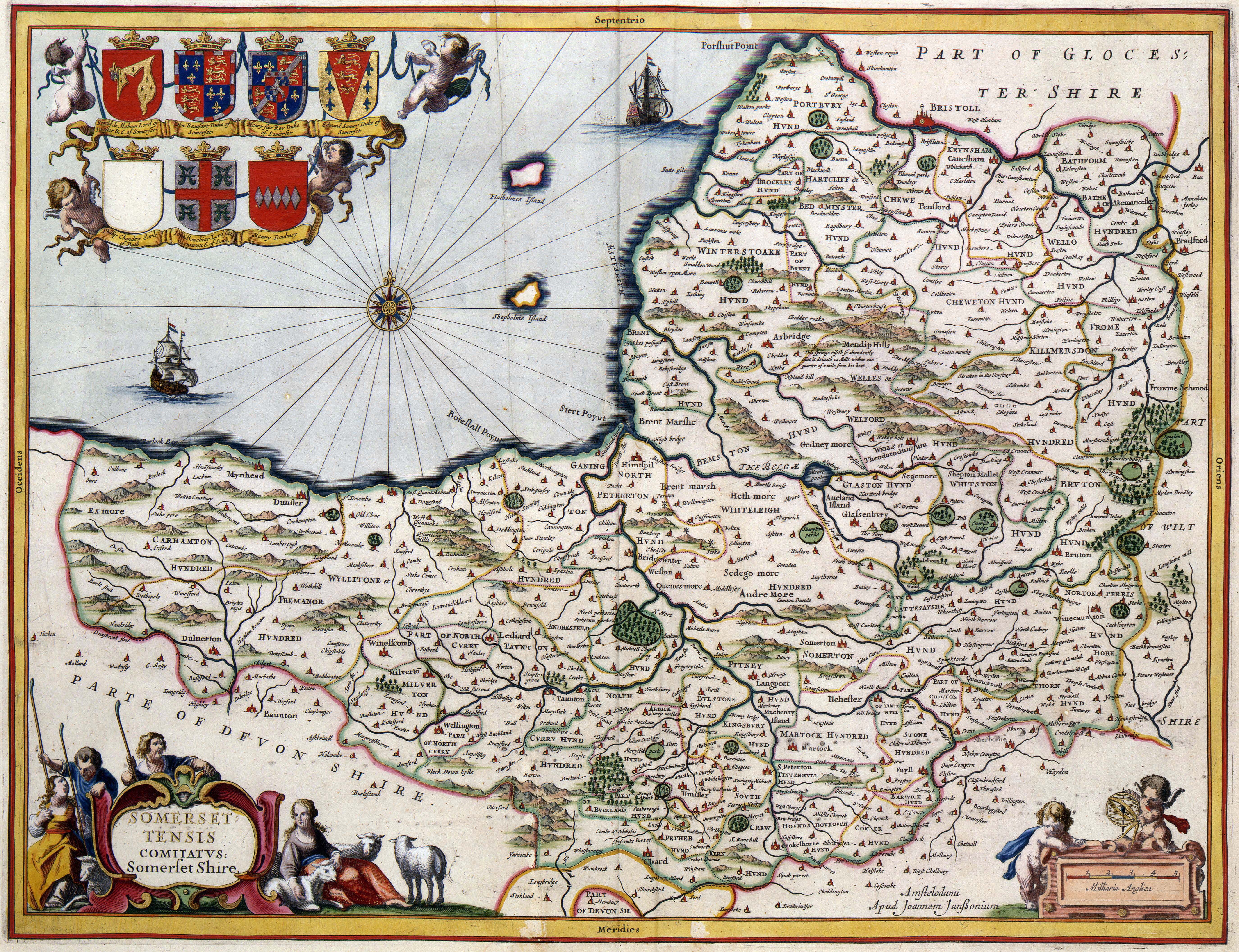

A map of the county in 1646
After the Romans left, Britain was invaded by Anglo-Saxon peoples. By AD 600 they had established control over much of what is now England, but Somerset was still in native British hands. The British held back Saxon advance into the south-west for some time longer, but by the early eighth century King Ine of Wessex had pushed the boundaries of the West Saxon kingdom far enough west to include Somerset.[21] The Saxon royal palace in Cheddar was used several times in the 10th century to host the Witenagemot.[22] After the Norman Conquest, the county was divided into 700 fiefs, and large areas were owned by the crown,[3] with fortifications such as Dunster Castle used for control and defence. Somerset contains HMP Shepton Mallet, England's oldest prison still in use, which opened in 1610.[23] In the English Civil War Somerset was largely Parliamentarian,[24] with key engagements being the Siege of Taunton[25] and the Battle of Langport.[26] In 1685 the Monmouth Rebellion was played out in Somerset and neighbouring Dorset.[27] The rebels landed at Lyme Regis and travelled north, hoping to capture Bristol and Bath, but they were defeated in the Battle of Sedgemoor at Westonzoyland, the last pitched battle fought in England.[28] Arthur Wellesley took his title, Duke of Wellington from the town of Wellington;[29] he is commemorated on a nearby hill by a large, spotlit obelisk, known as the Wellington Monument.
The Industrial Revolution in the Midlands and Northern England spelled the end for most of Somerset's cottage industries. Farming continued to flourish, however, and the Bath and West of England Society for the Encouragement of Agriculture, Arts, Manufactures and Commerce was founded in 1777 to improve farming methods. Despite this, 20 years later John Billingsley conducted a survey of the county's agriculture in 1795 and found that agricultural methods could still be improved.[30] Coal mining was an important industry in north Somerset during the 18th and 19th centuries, and by 1800 it was prominent in Radstock.[31] The Somerset Coalfield reached its peak production by the 1920s, but all the pits have now been closed, the last in 1973.[32] Most of the surface buildings have been removed, and apart from a winding wheel outside Radstock Museum, little evidence of their former existence remains. Further west, the Brendon Hills were mined for iron ore in the late 19th century; this was taken by rail to Watchet Harbour for shipment to the furnaces at Ebbw Vale.
Many Somerset soldiers died during the First World War, with the Somerset Light Infantry suffering nearly 5,000 casualties.[33] War memorials were put up in most of the county's towns and villages; only nine, described as the Thankful Villages, had none of their residents killed. During the Second World War the county was a base for troops preparing for the D-Day landings. Some of the hospitals which were built for the casualties of the war remain in use. The Taunton Stop Line was set up to repel a potential German invasion. The remains of its pill boxes can still be seen along the coast, and south through Ilminster and Chard.[34]
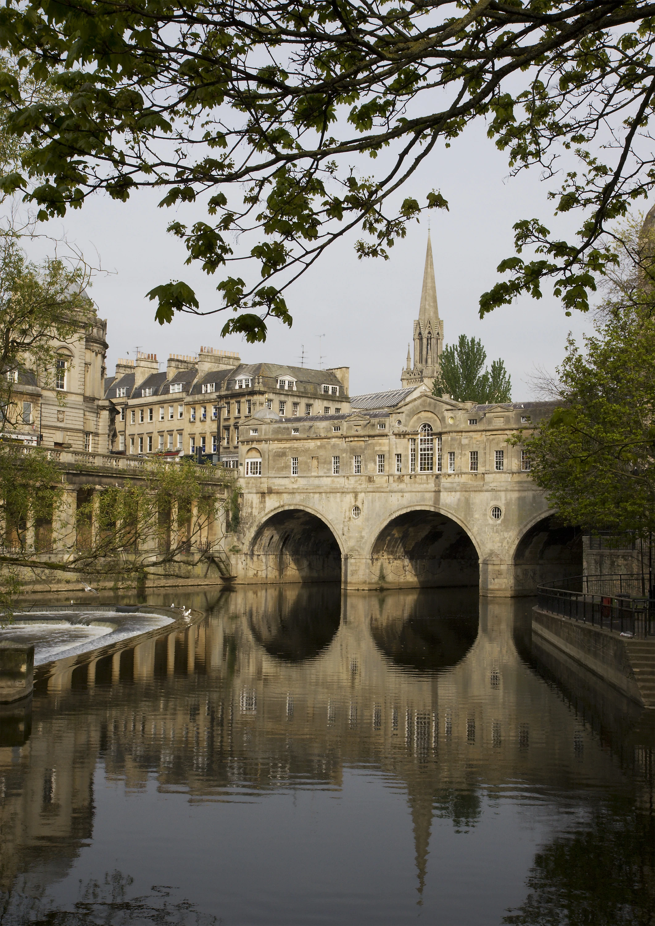
Palladian Pulteney Bridge at Bath
A number of decoy towns were constructed in Somerset in World War II to protect Bristol and other towns, at night. They were designed to mimic the geometry of "blacked out" streets, railway lines, and Bristol Temple Meads railway station, to encourage bombers away from these targets.[35] One, on the radio beam flight path to Bristol, was constructed on Beacon Batch.[35][36] It was laid out by Shepperton Film Studios, based on aerial photographs of the city's railway marshalling yards.[35] The decoys were fitted with dim red lights, simulating activities like the stoking of steam locomotives. Burning bales of straw soaked in creosote were used to simulate the effects of incendiary bombs dropped by the first wave of Pathfinder night bombers; meanwhile, incendiary bombs dropped on the correct location were quickly smothered, wherever possible. Drums of oil were also ignited to simulate the effect of a blazing city or town, with the aim of fooling subsequent waves of bombers into dropping their bombs on the wrong location.[35] The Chew Magna decoy town was hit by half-a-dozen bombs on 2 December 1940, and over a thousand incendiaries on 3 January 1941.[35] The following night the Uphill decoy town, protecting Weston-super-Mare's airfield, was bombed; a herd of dairy cows was hit, killing some and severely injuring others.[35]
Cities and towns[]
Somerton took over from Ilchester as the county town in the late thirteenth century,[37] but it declined in importance and the status of county town transferred to Taunton about 1366.[38] The county has two cities, Bath and Wells, and only a small number of towns. The largest urban areas in terms of population are Bath, Weston-super-Mare, Taunton, Yeovil and Bridgwater.[39] In many cases there are villages which are larger than their neighbouring towns; the village of Cheddar, for example, has three times the population of the nearby town of Axbridge. Many settlements developed because of their strategic importance in relation to geographical features, such as river crossings or valleys in ranges of hills. Examples include Axbridge on the River Axe, Castle Cary on the River Cary, North Petherton on the River Parrett, and Ilminster, where there was a crossing point on the River Isle. Midsomer Norton lies on the River Somer; while the Wellow Brook and the Fosseway Roman road run through Radstock. Chard is the most southerly town in Somerset, and at an altitude of 121 m (397 ft) it is also the highest.[40]
Physical geography[]
Geology[]
Much of the landscape of Somerset falls into types determined by the underlying geology. These landscapes are the limestone karst and lias of the north, the clay vales and wetlands of the centre, the oolites of the east and south, and the Devonian sandstone of the west.[41]
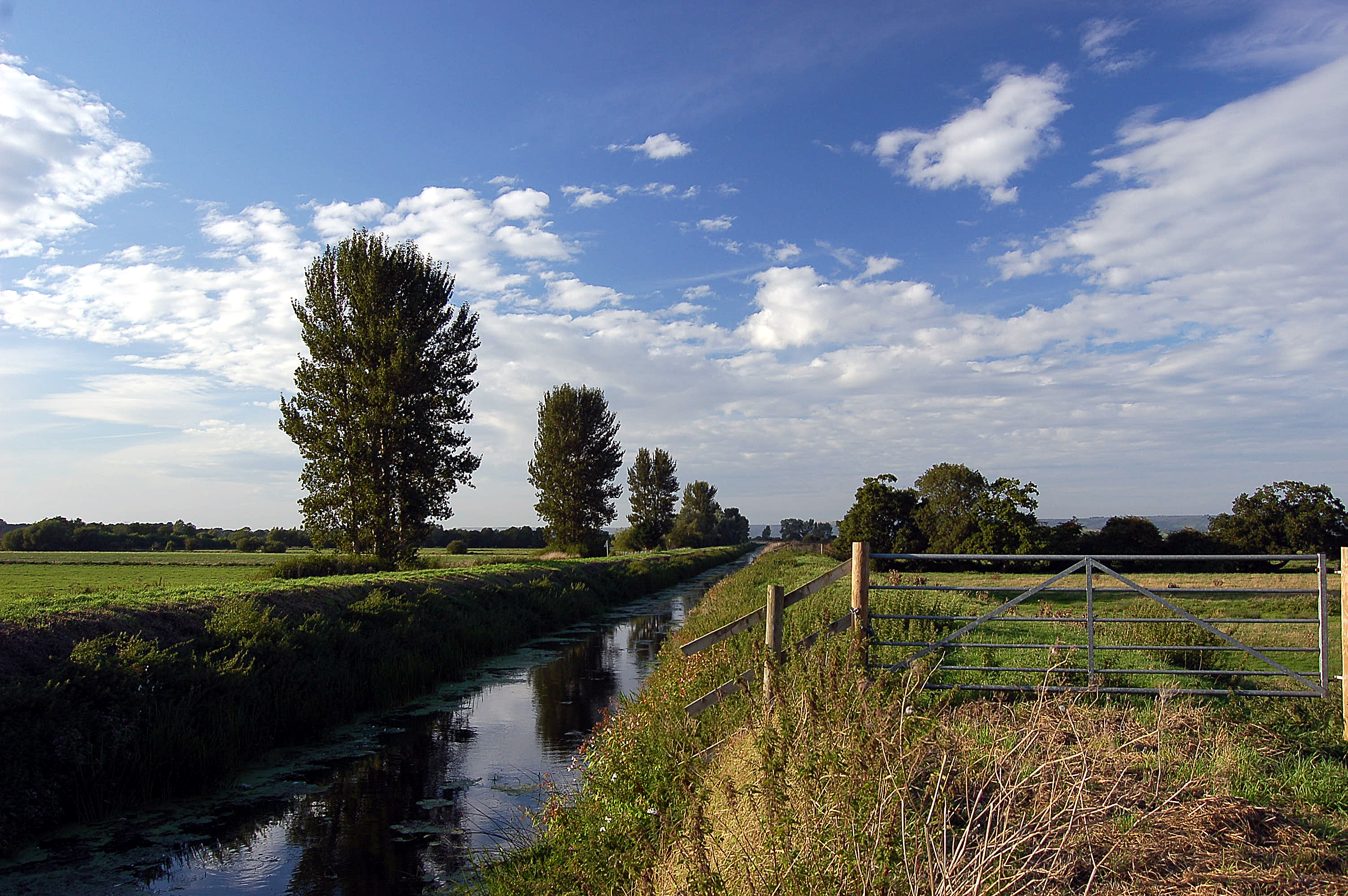

The River Brue in an artificial channel draining farmland near Glastonbury
To the north-east of the Somerset Levels, the Mendip Hills are moderately high limestone hills. The central and western Mendip Hills was designated an Area of Outstanding Natural Beauty in 1972 and covers 198 km2 (76 sq mi).[42] The main habitat on these hills is calcareous grassland, with some arable agriculture. To the south-west of the Somerset Levels are the Quantock Hills which was England's first Area of Outstanding Natural Beauty designated in 1956[43] which is covered in heathland, oak woodlands, ancient parklands with plantations of conifer and covers 99 square kilometres. The Somerset Coalfield is part of a larger coalfield which stretches into Gloucestershire. To the north of the Mendip hills is the Chew Valley and to the south, on the clay substrate, are broad valleys which support dairy farming and drain into the Somerset Levels.
Caves and rivers[]
There is an extensive network of caves, including Wookey Hole, underground rivers, and gorges, including the Cheddar Gorge and Ebbor Gorge.[44] The county has many rivers, including the Axe, Brue, Cary, Parrett, Sheppey, Tone and Yeo. These both feed and drain the flat levels and moors of mid and west Somerset.[45] In the north of the county the River Chew flows into the Bristol Avon. The Parrett is tidal almost to Langport, where there is evidence of two Roman wharfs.[46] At the same site during the reign of King Charles I, river tolls were levied on boats to pay for the maintenance of the bridge.[46]
Levels and moors[]


_from_the_tor_arp.jpg)
The town of Glastonbury looking west from the top of Glastonbury Tor. The fields in the distance are the Somerset Levels.
The Somerset Levels (or Somerset Levels and Moors as they are less commonly but more correctly known) are a sparsely populated wetland area of central Somerset, between the Quantock and Mendip hills. They consist of marine clay levels along the coast, and the inland (often peat based) moors. The Levels are divided into two by the Polden Hills; land to the south is drained by the River Parrett while land to the north is drained by the River Axe and the River Brue. The total area of the Levels amounts to about 647.5 square kilometres (160,000 acres)[47] and broadly corresponds to the administrative district of Sedgemoor but also includes the south west of Mendip district. Approximately 70% of the area is grassland and 30% is arable.[47] Stretching about 32 kilometres (20 mi) inland, this expanse of flat land barely rises above sea level. Before it was drained, much of the land was under a shallow brackish sea in winter and was marsh land in summer. Drainage began with the Romans, and was restarted at various times: by the Anglo-Saxons; in the Middle Ages by the Glastonbury Abbey, from 1400–1770; and during the Second World War, with the construction of the Huntspill River. Pumping and management of water levels still continues.[48]


The Exmoor landscape with the native Exmoor Pony.
The North Somerset Levels basin, north of the Mendips, covers a smaller geographical area than the Somerset Levels; and forms a coastal area around Avonmouth. It too was reclaimed by draining.[48][49] It is mirrored, across the Severn Estuary, in Wales, by a similar low-lying area: the Caldicot and Wentloog Levels.[49]
In the far west of the county, running into Devon, is Exmoor, a high Devonian sandstone moor, which was designated as a national park in 1954, under the 1949 National Parks and Access to the Countryside Act.[50] The highest point in Somerset is Dunkery Beacon on Exmoor, with an altitude of 519 metres (1,703 feet).[51] Over 100 sites in Somerset have been designated as Sites of Special Scientific Interest.
Coastline[]
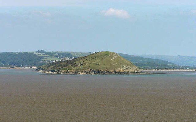

Brean Down from Steep Holm


The marina in the coastal town of Watchet
The 64 km (40 mi) coastline of the Bristol Channel and Severn Estuary forms part of the northern border of Somerset.[52] The Bristol Channel has the second largest tidal range in the world. At Burnham-on-Sea, for example, the tidal range of a spring tide is more than 12 metres (39 feet).[53] Proposals for the construction of a Severn Barrage aim to harness this energy. The island of Steep Holm in the Bristol Channel is within the historic county and is now administered by North Somerset Council.[54]
The main coastal towns are, from the west to the north-east, Minehead, Watchet, Burnham-on-Sea, Weston-super-Mare, Clevedon and Portishead. The coastal area between Minehead and the eastern extreme of the administrative county's coastline at Brean Down is known as Bridgwater Bay, and is a National Nature Reserve.[55] North of that, the coast forms Weston Bay and Sand Bay whose northern tip, Sand Point, marks the lower limit of the Severn Estuary.[56] In the mid and north of the county the coastline is low as the level wetlands of the levels meet the sea. In the west, the coastline is high and dramatic where the plateau of Exmoor meets the sea, with high cliffs and waterfalls.[57]
Climate[]
Along with the rest of South West England, Somerset has a temperate climate which is generally wetter and milder than the rest of the country.[58] The annual mean temperature is approximately 10 °C (50.0 °F). Seasonal temperature variation is less extreme than most of the United Kingdom because of the adjacent sea temperatures. The summer months of July and August are the warmest with mean daily maxima of approximately 21 °C (69.8 °F). In winter mean minimum temperatures of 1 °C (33.8 °F) or 2 °C (35.6 °F) are common.[58] In the summer the Azores high pressure affects the south-west of England, but convective cloud sometimes forms inland, reducing the number of hours of sunshine. Annual sunshine rates are slightly less than the regional average of 1,600 hours.[58] In December 1998 there were 20 days without sun recorded at Yeovilton. Most the rainfall in the south-west is caused by Atlantic depressions or by convection. Most of the rainfall in autumn and winter is caused by the Atlantic depressions, which is when they are most active. In summer, a large proportion of the rainfall is caused by sun heating the ground leading to convection and to showers and thunderstorms. Average rainfall is around 700 mm (28 in). About 8–15 days of snowfall is typical. November to March have the highest mean wind speeds, and June to August the lightest winds. The predominant wind direction is from the south-west.[58]
| Climate data for Yeovilton, England (1971–2000) data | |||||||||||||
|---|---|---|---|---|---|---|---|---|---|---|---|---|---|
| Month | Jan | Feb | Mar | Apr | May | Jun | Jul | Aug | Sep | Oct | Nov | Dec | Year |
| Average high °C (°F) | 8.1 (46.6) |
8.3 (46.9) |
10.6 (51.1) |
12.9 (55.2) |
16.5 (61.7) |
19.3 (66.7) |
21.7 (71.1) |
21.5 (70.7) |
18.6 (65.5) |
14.8 (58.6) |
11.1 (52.0) |
9.0 (48.2) |
14.4 (57.9) |
| Daily mean °C (°F) | 4.8 (40.6) |
4.8 (40.6) |
6.7 (44.1) |
8.3 (46.9) |
11.7 (53.1) |
14.5 (58.1) |
16.8 (62.2) |
16.6 (61.9) |
14.1 (57.4) |
10.9 (51.6) |
7.4 (45.3) |
5.7 (42.3) |
10.2 (50.4) |
| Average low °C (°F) | 1.4 (34.5) |
1.3 (34.3) |
2.7 (36.9) |
3.7 (38.7) |
6.8 (44.2) |
9.7 (49.5) |
11.9 (53.4) |
11.7 (53.1) |
9.6 (49.3) |
6.9 (44.4) |
3.6 (38.5) |
2.4 (36.3) |
6.0 (42.8) |
| Precipitation mm (inches) | 72.0 (2.835) |
55.6 (2.189) |
56.5 (2.224) |
47.3 (1.862) |
48.9 (1.925) |
57.2 (2.252) |
48.9 (1.925) |
56.6 (2.228) |
64.5 (2.539) |
67.9 (2.673) |
65.8 (2.591) |
83.3 (3.28) |
724.5 (28.524) |
| Avg. rainy days | 12.5 | 10.2 | 10.9 | 9.2 | 8.8 | 8.5 | 6.9 | 8.6 | 10.1 | 11.3 | 11.6 | 12.6 | 121.2 |
| Mean monthly sunshine hours | 50.2 | 68.9 | 107.6 | 155.4 | 193.1 | 186.0 | 205.8 | 197.8 | 139.8 | 101.1 | 70.2 | 46.8 | 1,522.7 |
| Source: [59] | |||||||||||||
| Climate data for Nettlecombe, England (1971–2000) data | |||||||||||||
|---|---|---|---|---|---|---|---|---|---|---|---|---|---|
| Month | Jan | Feb | Mar | Apr | May | Jun | Jul | Aug | Sep | Oct | Nov | Dec | Year |
| Average high °C (°F) | 7.9 (46.2) |
8.0 (46.4) |
10.2 (50.4) |
12.2 (54.0) |
15.6 (60.1) |
18.3 (64.9) |
20.7 (69.3) |
20.5 (68.9) |
17.8 (64.0) |
14.2 (57.6) |
10.8 (51.4) |
8.8 (47.8) |
13.8 (56.8) |
| Daily mean °C (°F) | 4.9 (40.8) |
4.9 (40.8) |
6.6 (43.9) |
7.9 (46.2) |
10.9 (51.6) |
13.6 (56.5) |
15.8 (60.4) |
15.7 (60.3) |
13.4 (56.1) |
10.5 (50.9) |
7.5 (45.5) |
5.9 (42.6) |
9.8 (49.6) |
| Average low °C (°F) | 1.9 (35.4) |
1.8 (35.2) |
3.0 (37.4) |
3.6 (38.5) |
6.2 (43.2) |
8.8 (47.8) |
10.9 (51.6) |
10.8 (51.4) |
9.0 (48.2) |
6.7 (44.1) |
4.1 (39.4) |
2.9 (37.2) |
5.8 (42.4) |
| Precipitation mm (inches) | 123.6 (4.866) |
87.6 (3.449) |
80.6 (3.173) |
66.3 (2.61) |
62.6 (2.465) |
58.7 (2.311) |
43.4 (1.709) |
66.5 (2.618) |
85.4 (3.362) |
108.6 (4.276) |
106.6 (4.197) |
128.7 (5.067) |
1,018.6 (40.102) |
| Avg. rainy days | 15.1 | 11.7 | 11.7 | 10.3 | 9.9 | 8.7 | 7.3 | 8.7 | 10.4 | 13.6 | 14.1 | 14.6 | 136.1 |
| Source: [60] | |||||||||||||
Economy and industry[]


The Dunster Yarn Market was built in 1609 for the trading of local cloth
Somerset has few industrial centres, but it does have a variety of light industry and high technology businesses, along with traditional agriculture and an increasingly important tourism sector, resulting in an unemployment rate of 2.5%.[61] Bridgwater was developed during the Industrial Revolution as the area's leading port. The River Parrett was navigable by large ships as far as Bridgwater. Cargoes were then loaded onto smaller boats at Langport Quay, next to the Bridgwater Bridge, to be carried further up river to Langport;[62] or they could turn off at Burrowbridge and then travel via the River Tone to Taunton.[46] The Parrett is now only navigable as far as Dunball Wharf. Bridgwater, in the 19th and 20th centuries, was a centre for the manufacture of bricks and clay roof tiles, and later cellophane, but those industries have now stopped.[62] With its good links to the motorway system, Bridgwater has developed as a distribution hub for companies such as Argos, Toolstation, Morrisons and Gerber Juice. AgustaWestland manufactures helicopters in Yeovil,[63] and Normalair Garratt, builder of aircraft oxygen systems, is also based in the town.[64] Many towns have encouraged small-scale light industries, such as Crewkerne's Ariel Motor Company, one of the UK's smallest car manufacturers.
Somerset is an important supplier of defence equipment and technology. A Royal Ordnance Factory, ROF Bridgwater was built at the start of the Second World War, between the villages of Puriton and Woolavington,[65] to manufacture explosives. The site was decommissioned and closed in July 2008.[66] Templecombe has Thales Underwater Systems,[67] and Taunton presently has the United Kingdom Hydrographic Office and Avimo, which became part of Thales Optics. It has been announced twice, in 2006 and 2007, that manufacturing is to end at Thales Optics' Taunton site,[68] but the trade unions and Taunton Deane District Council are working to reverse or mitigate these decisions. Other high-technology companies include the optics company Gooch and Housego, at Ilminster. There are Ministry of Defence offices in Bath, and Norton Fitzwarren is the home of 40 Commando Royal Marines. The Royal Naval Air Station in Yeovilton, is one of Britain's two active Fleet Air Arm bases and is home to the Royal Navy's Lynx helicopters and the Royal Marines Commando Westland Sea Kings. Around 1,675 service and 2,000 civilian personnel are stationed at Yeovilton and key activities include training of aircrew and engineers and the Royal Navy's Fighter Controllers and surface-based aircraft controllers.


Somerset scrumpy cider
Agriculture and food and drink production continue to be major industries in the county, employing over 15,000 people.[69] Apple orchards were once plentiful, and Somerset is still a major producer of cider. The towns of Taunton and Shepton Mallet are involved with the production of cider, especially Blackthorn Cider, which is sold nationwide, and there are specialist producers such as Burrow Hill Cider Farm and Thatchers Cider. Gerber Products Company in Bridgwater is the largest producer of fruit juices in Europe, producing brands such as "Sunny Delight" and "Ocean Spray." Development of the milk-based industries, such as Ilchester Cheese Company and Yeo Valley Organic, have resulted in the production of ranges of desserts, yoghurts and cheeses,[70] including Cheddar cheese—some of which has the West Country Farmhouse Cheddar PDO.
Traditional willow growing and weaving is not as extensive as it used to be but is still carried out on the Somerset Levels and is commemorated at the Willows and Wetlands Visitor Centre.[71] Fragments of willow basket were found near the Glastonbury Lake Village, and it was also used in the construction of several Iron Age causeways.[72] The willow was harvested using a traditional method of pollarding, where a tree would be cut back to the main stem. During the 1930s more than 3,600 hectares (8,900 acres) of willow were being grown commercially on the Levels. Largely due to the displacement of baskets with plastic bags and cardboard boxes, the industry has severely declined since the 1950s. By the end of the 20th century only about 140 hectares (350 acres) were grown commercially, near the villages of Burrowbridge, Westonzoyland and North Curry.[47] The Somerset Levels is now the only area in the UK where basket willow is grown commercially.
Towns such as Castle Cary and Frome grew around the medieval weaving industry. Street developed as a centre for the production of woollen slippers and, later, boots and shoes, with C&J Clark establishing its headquarters in the town. C&J Clark's shoes are no longer manufactured there as the work was transferred to lower-wage areas, such as China and Asia.[73] Instead, in 1993, redundant factory buildings were converted to form Clarks Village, the first purpose-built factory outlet in the UK. C&J Clark also had shoe factories, at one time at Bridgwater, Minehead, Westfield and Weston super Mare to provide employment outside the main summer tourist season, but those satellite sites were closed in the late 1980s, before the main site at Street. Dr. Martens shoes were also made in Somerset, by the Northampton-based R. Griggs Group, using redundant skilled shoemakers from C&J Clark; that work has also been transferred to Asia.

Stone quarries are still a major employer in Somerset
The county has a long tradition of supplying freestone and building stone. Quarries at Doulting supplied freestone used in the construction of Wells Cathedral. Bath Stone is also widely used. Ralph Allen promoted its use in the early 18th century, as did Hans Price in the 19th century, but it was used long before then. It was mined underground at Combe Down and Bathampton Down Mines, and as a result of cutting the Box Tunnel, at locations in Wiltshire such as Box.[74][75][76] Bath stone is still used on a reduced scale today, but more often as a cladding rather than a structural material.[74] Further south, Hamstone is the colloquial name given to stone from Ham Hill, which is also widely used in the construction industry. Blue Lias has been used locally as a building stone and as a raw material for lime mortar and Portland cement. Until the 1960s, Puriton had Blue Lias stone quarries, as did several other Polden villages. Its quarries also supplied a cement factory at Dunball, adjacent to the King's Sedgemoor Drain. Its derelict, early 20th century remains, was removed when the M5 motorway was constructed in the mid-1970s.[77] Since the 1920s, the county has supplied aggregates. Foster Yeoman is Europe's large supplier of limestone aggregates, with quarries at Merehead Quarry. It has a dedicated railway operation, Mendip Rail, which is used to transport aggregates by rail from a group of Mendip quarries.[78]
Tourism is a major industry, estimated in 2001 to support around 23,000 people. Attractions include the coastal towns, part of the Exmoor National Park, the West Somerset Railway (a heritage railway), and the museum of the Fleet Air Arm at RNAS Yeovilton. The town of Glastonbury has mythical associations, including legends of a visit by the young Jesus of Nazareth and Joseph of Arimathea, with links to the Holy Grail, King Arthur, and Camelot, identified by some as Cadbury Castle, an Iron Age hill fort. Glastonbury also gives its name to an annual open-air rock festival held in nearby Pilton. There are show caves open to visitors in the Cheddar Gorge, as well as its locally produced cheese, although there is now only one remaining cheese maker in the village of Cheddar.
In November 2008, a public sector inward investment organisation was launched, called Into Somerset,[79] with the intention of growing the county's economy by promoting it to businesses that may wish to relocate from other parts of the UK (especially London) and the world.
Demography[]
| Somerset Compared | |||||
|---|---|---|---|---|---|
| UK Census 2001 | Somerset C.C.[80] | North Somerset UA[81] | BANES UA[82] | South West England[82] | England[82] |
| Total population | 498,093 | 188,564 | 169,040 | 4,928,434 | 49,138,831 |
| Foreign born | 7.6% | 9.5% | 11.2% | 9.4% | 9.2% |
| White | 98.8% | 97.1% | 97.3% | 97.7% | 91% |
| Asian | 0.3% | 1.7% | 0.5% | 0.7% | 4.6% |
| Black | 0.2% | 0.9% | 0.5% | 0.4% | 2.3% |
| Christian | 76.7% | 75.0% | 71.0% | 74.0% | 72% |
| Muslim | 0.2% | 0.2% | 0.4% | 0.5% | 3.1% |
| Hindu | 0.1% | 0.1% | 0.2% | 0.2% | 1.1% |
| No religion | 14.9% | 16.6% | 19.5% | 16.8% | 15% |
| Over 75 years old | 9.6% | 9.9% | 8.9% | 9.3% | 7.5% |
| Unemployed | 2.5% | 2.1% | 2.0% | 2.6% | 3.3% |
In the 2001 census the population of the Somerset County Council area was 498,093[83] with 169,040 in Bath and North East Somerset,[84] and 188,564 in North Somerset[85] giving a total for the historic county of 855,697.
Population growth is higher than the national average, with a 6.4% increase, in the Somerset County Council area, since 1991, and a 17% increase since 1981. The population density is 1.4 persons per hectare, which can be compared to 2.07 persons per hectare for the South West region. Within the county, population density ranges 0.5 in West Somerset to 2.2 persons per hectare in Taunton Deane. The percentage of the population who are economically active is higher than the regional and national average, and the unemployment rate is lower than the regional and national average.[86]
Somerset has a high indigenous British population, with 98.8% registering as white British and 92.4% of these as born in the United Kingdom. Chinese is the largest ethnic group, while the black minority ethnic proportion of the total population is 2.9%.[52] Over 25% of Somerset's population is concentrated in Taunton, Bridgwater and Yeovil. The rest of the county is rural and sparsely populated. Over 9 million tourist nights are spent in Somerset each year, which significantly increases the population at peak times.[52]
| Population since 1801 | |||||||||||||
| Year | 1801 | 1851 | 1901 | 1911 | 1921 | 1931 | 1941 | 1951 | 1961 | 1971 | 1981 | 1991 | 2001 |
|---|---|---|---|---|---|---|---|---|---|---|---|---|---|
| Somerset CC area[87] | 187,266 | 276,684 | 277,563 | 280,215 | 282,411 | 284,740 | 305,244 | 327,505 | 355,292 | 385,698 | 417,450 | 468,395 | 498,093 |
| BANES[88] | 57,188 | 96,992 | 107,637 | 113,732 | 113,351 | 112,972 | 123,185 | 134,346 | 144,950 | 156,421 | 154,083 | 164,737 | 169,045 |
| North Somerset[89] | 16,670 | 33,774 | 60,066 | 68,410 | 75,276 | 82,833 | 91,967 | 102,119 | 119,509 | 139,924 | 160,353 | 179,865 | 188,556 |
| Total | 261,124 | 407,450 | 445,266 | 462,357 | 471,038 | 479,758 | 520,396 | 563,970 | 619,751 | 682,043 | 731,886 | 812,997 | 855,694 |
Politics[]

Weston-super-Mare town hall, the administrative headquarters of North Somerset
The county is divided into nine constituencies for the election of Members of Parliament (MPs) to the House of Commons. As of May 2010, the constituencies of Bridgwater and West Somerset, North East Somerset, North Somerset and Weston-super-Mare elect Conservative MPs, while Bath, Somerton and Frome, Taunton Deane, Wells and Yeovil return Liberal Democrats.[90] Residents of Somerset also form part of the electorate for the South West England constituency for elections to the European Parliament.[91]
Local government[]
The ceremonial county of Somerset consists of a non-metropolitan county, administered by Somerset County Council, and two unitary authorities.
The districts of Somerset are West Somerset, South Somerset, Taunton Deane, Mendip and Sedgemoor. The two administratively independent unitary authorities, which were established on 1 April 1996 following the break-up of the county of Avon, are North Somerset and Bath and North East Somerset. These unitary authorities include areas that were once part of Somerset before the creation of Avon in 1974.[92] In 2007, proposals to abolish the district councils in favour of a single Somerset unitary authority were rejected following local opposition.[93]
Culture[]


The west front of Wells Cathedral
Somerset has traditions of art, music and literature. Wordsworth and Coleridge wrote while staying in Coleridge Cottage, Nether Stowey.[94] The writer Evelyn Waugh spent his last years in the village of Combe Florey.[95] The novelist John Cowper Powys (1872-1963) lived in the Somerset village of Montacute from 1885 until 1894 and his novels Wood and Stone (1915) and A Glastonbury Romance (1932) are set in Somerset.
Traditional folk music, both song and dance, was important in the agricultural communities. Somerset songs were collected by Cecil Sharp and incorporated into works such as Holst's A Somerset Rhapsody. Halsway Manor near Williton is an international centre for folk music. The tradition continues today with groups such as The Wurzels specialising in Scrumpy and Western music.[96]
The Glastonbury Festival of Contemporary Performing Arts takes place most years in Pilton, near Shepton Mallet, attracting over 170,000 music and culture lovers from around the world to see world-famous entertainers.[97] The Big Green Gathering which grew out of the Green fields at the Glastonbury Festival is held in the Mendip Hills between Charterhouse and Compton Martin each summer.[98] The annual Bath Literature Festival is one of several local festivals in the county; others include the Frome Festival and the Trowbridge Village Pump Festival, which, despite its name, is held at Farleigh Hungerford in Somerset. The annual circuit of West Country Carnivals is held in a variety of Somerset towns during the autumn, forming a major regional festival, and the largest Festival of Lights in Europe.[99]
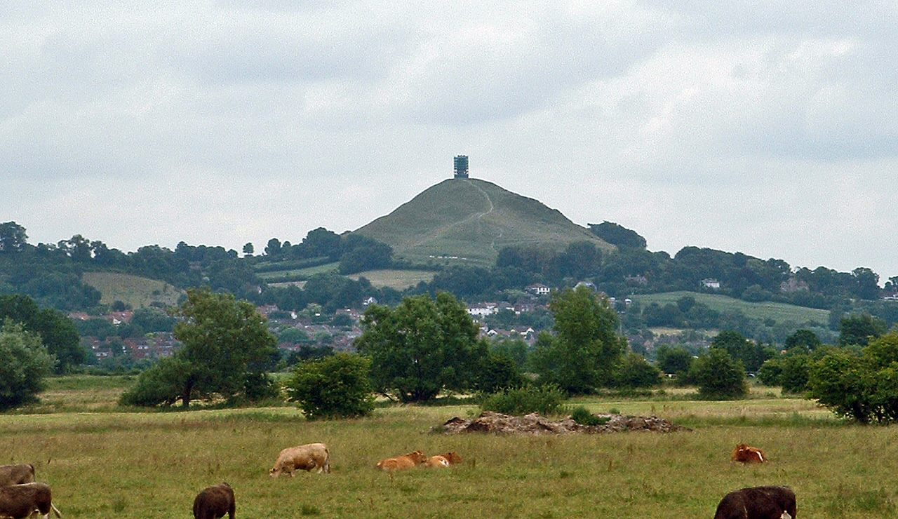
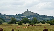
Glastonbury Tor
In Arthurian legend, Avalon became associated with Glastonbury Tor when monks at Glastonbury Abbey claimed to have discovered the bones of King Arthur and his queen.[100] What is more certain is that Glastonbury was an important religious centre by 700 and claims to be "the oldest above-ground Christian church in the World"[101] situated "in the mystical land of Avalon." The claim is based on dating the founding of the community of monks at AD 63, the year of the legendary visit of Joseph of Arimathea, who was supposed to have brought the Holy Grail.[101] During the Middle Ages there were also important religious sites at Woodspring Priory and Muchelney Abbey. The present Diocese of Bath and Wells covers Somerset – with the exception of the Parish of Abbots Leigh with Leigh Woods in North Somerset – and a small area of Dorset. The Episcopal seat of the Bishop of Bath and Wells is now in the Cathedral Church of Saint Andrew in the city of Wells, having previously been at Bath Abbey. Before the English Reformation, it was a Roman Catholic diocese; the county now falls within the Roman Catholic Diocese of Clifton. The Benedictine monastery Saint Gregory's Abbey, commonly known as Downside Abbey, is at Stratton-on-the-Fosse, and the ruins of the former Cistercian Cleeve Abbey are near the village of Washford.

Tyntesfield
The county has several museums; those at Bath include the American Museum in Britain, the Building of Bath Collection, the Herschel Museum of Astronomy, the Jane Austen Centre, and the Roman Baths. Other visitor attractions which reflect the cultural heritage of the county include: Claverton Pumping Station, Dunster Working Watermill, the Fleet Air Arm Museum at Yeovilton, Nunney Castle, The Helicopter Museum in Weston-super-Mare, King John's Hunting Lodge in Axbridge, Blake Museum Bridgwater, Radstock Museum, Museum of Somerset in Taunton, the Somerset Rural Life Museum in Glastonbury, and Westonzoyland Pumping Station Museum.
Somerset has 11,500 listed buildings, 523 Scheduled Monuments, 192 conservation areas,[102] 41 parks and gardens including those at Barrington Court, Holnicote Estate, Prior Park Landscape Garden and Tintinhull Garden, 36 English Heritage sites and 19 National Trust sites,[1] including Clevedon Court, Fyne Court, Montacute House and Tyntesfield as well as Stembridge Tower Mill, the last remaining thatched windmill in England.[1] Other historic houses in the county which have remained in private ownership or used for other purposes include Halswell House and Marston Bigot. A key contribution of Somerset architecture is its medieval church towers. Jenkins writes, "These structures, with their buttresses, bell-opening tracery and crowns, rank with Nottinghamshire alabaster as England's finest contribution to medieval art."[103]
Bath Rugby play at the Recreation Ground in Bath, and the Somerset County Cricket Club are based at the County Ground in Taunton. The county gained its first Football League club in 2003, when Yeovil Town won promotion to Division Three as Football Conference champions.[104] They had achieved numerous FA Cup victories over Football League sides in the past 50 years, and since joining the elite they have won promotion again—as League Two champions in 2005. They came close to yet another promotion in 2007, when they reached the League One playoff final, but lost to Blackpool at the newly reopened Wembley Stadium. Horse racing courses are at Taunton and Wincanton.
In addition to English national newspapers the county is served by the regional Western Daily Press and local newspapers including: the Weston & Somerset Mercury, the Bath Chronicle, Chew Valley Gazette, Somerset County Gazette, Clevedon Mercury and the Mendip Times. Television and radio are provided by BBC Somerset, Heart West Country, The Breeze (Yeovil & South Somerset) Yeovil, and HTV, now known as ITV Wales & West Ltd, but still commonly referred to as HTV.[105]
Recently there have been proposals for the introduction of an official Somerset flag for the ceremonial county.
Transport[]
Somerset has 6,531 km (4,058 mi) of roads. The main arterial routes, which include the M5 motorway, A303, A37, A38 and A39, give good access across the county, but many areas can only be accessed via narrow lanes.[52] Rail services are provided by the West of England Main Line through Yeovil, the Bristol to Taunton Line, Heart of Wessex Line which runs from Bristol to Weymouth and the Reading to Taunton line. Bristol Airport provides national and international air services.
The Somerset Coal Canal was built in the early 19th century to reduce the cost of transportation of coal and other heavy produce.[46] The first 16 kilometres (10 mi), running from a junction with the Kennet and Avon Canal, along the Cam valley, to a terminal basin at Paulton, were in use by 1805, together with several tramways. A planned 11.7 km (7.3 mi) branch to Midford was never built, but in 1815 a tramway was laid along its towing path. In 1871 the tramway was purchased by the Somerset and Dorset Joint Railway (S&DJR),[106][107] and operated until the 1950s.
The 19th century saw improvements to Somerset's roads with the introduction of turnpikes, and the building of canals and railways. Nineteenth-century canals included the Bridgwater and Taunton Canal, Westport Canal, Glastonbury Canal and Chard Canal.[12][46] The Dorset and Somerset Canal was proposed, but little of it was ever constructed and it was abandoned in 1803.[46]


The West Somerset Railway
The usefulness of the canals was short-lived, though some have now been restored for recreation. The 19th century also saw the construction of railways to and through Somerset. The county was served by five pre-1923 Grouping railway companies: the Great Western Railway (GWR);[108][109] a branch of the Midland Railway (MR) to Bath Green Park (and another one to Bristol);[110] the Somerset and Dorset Joint Railway,[109][111][112] and the London and South Western Railway (L&SWR).[109][113] The former main lines of the GWR are still in use today, although many of its branch lines were scrapped. The former lines of the Somerset and Dorset Joint Railway closed completely,[114] as has the branch of the Midland Railway to Bath Green Park (and to Bristol St Philips); however, the L&SWR survived as a part of the present West of England Main Line. None of these lines, in Somerset, are electrified. Two branch lines, the West and East Somerset Railways, were rescued and transferred back to private ownership as "heritage" lines. The fifth railway was a short-lived light railway, the Weston, Clevedon and Portishead Railway. The West Somerset Mineral Railway carried the iron ore from the Brendon Hills to Watchet.
Until the 1960s the piers at Weston-super-Mare, Clevedon, Portishead and Minehead were served by the paddle steamers of P and A Campbell who ran regular services to Barry and Cardiff as well as Ilfracombe and Lundy Island. The pier at Burnham-on-Sea was used for commercial goods, one of the reasons for the Somerset and Dorset Railway was to provide a link between the Bristol Channel and the English Channel. The pier at Burnham-on-Sea is the shortest pier in the UK.[115] In the 1970s the Royal Portbury Dock was constructed to provide extra capacity for the Port of Bristol.
For long-distance holiday traffic travelling through the county to and from Devon and Cornwall, Somerset is often regarded as a marker on the journey. North–south traffic moves through the county via the M5 Motorway.[116] Traffic to and from the east travels either via the A303 road, or the M4 Motorway, which runs east–west, crossing the M5 just beyond the northern limits of the county.
Education[]
State schools in Somerset are provided by three Local Education Authorities: Bath and North East Somerset, North Somerset, and the larger Somerset County Council. All state schools are comprehensive. In some areas primary, infant and junior schools cater for ages four to eleven, after which the pupils move on to secondary schools. There is a three-tier system of first, middle and upper schools in the Cheddar Valley,[117] and in West Somerset, while most other schools in the county use the two-tier system.[118] Somerset has 30 state and 17 independent secondary schools;[119] Bath and North East Somerset has 13 state and 5 independent secondary schools;[120] and North Somerset has 10 state and 2 independent secondary schools, excluding sixth form colleges.[121]
| % of pupils gaining 5 grades A-C including English and Maths in 2006 (average for England is 45.8%) | |
|---|---|
| Education Authority | % |
| Bath and North East Somerset (Unitary Authority) | 52.0% |
| West Somerset | 51.0% |
| Taunton Deane | 49.5% |
| Mendip | 47.7% |
| North Somerset (Unitary Authority) | 47.4% |
| South Somerset | 42.3% |
| Sedgemoor | 41.4% |
Some of the county's secondary schools have specialist school status. Some schools have sixth forms and others transfer their sixth formers to colleges. Several schools can trace their origins back many years, such as The Blue School in Wells and Richard Huish College in Taunton.[122] Others have changed their names over the years such as Beechen Cliff School which was started in 1905 as the City of Bath Boys' School and changed to its present name in 1972 when the grammar school was amalgamated with a local secondary modern school, to form a comprehensive school. Many others were established and built since the Second World War. In 2006, 5,900 pupils in Somerset sat GCSE examinations, with 44.5% achieving 5 grades A-C including English and Maths (compared to 45.8% for England).
Sexey's School is a state boarding school in Bruton that also takes day pupils from the surrounding area.[123] The Somerset LEA also provides special schools such as Farleigh College, which caters for children aged between 10 and 17 with special educational needs.[124] Provision for pupils with special educational needs is also made by the mainstream schools.
There is also a range of independent or public schools. Many of these are for pupils between 11 and 18 years, such as King's College, Taunton and Taunton School. King's School, Bruton, was founded in 1519 and received royal foundation status around 30 years later in the reign of Edward VI. Millfield is the largest co-educational boarding school. There are also preparatory schools for younger children, such as All Hallows, and Hazlegrove Preparatory School. Chilton Cantelo School offers places both to day pupils and boarders aged 7 to 16. Other schools provide education for children from the age of 3 or 4 years through to 18, such as King Edward's School, Bath, Queen's College, Taunton and Wells Cathedral School which is one of the five established musical schools for school-age children in Britain.[125] Some of these schools have religious affiliations, such as Monkton Combe School, Prior Park College, Sidcot School which is associated with the Religious Society of Friends,[126] Downside School which is a Roman Catholic public school in Stratton-on-the-Fosse, situated next to the Benedictine Downside Abbey,[127] and Kingswood School, which was founded by John Wesley in 1748 in Kingswood near Bristol, originally for the education of the sons of the itinerant ministers (clergy) of the Methodist Church.[128]
Further and higher education[]
A wide range of adult education and further education courses is available in Somerset, in schools, colleges and other community venues. The colleges include Bridgwater College, City of Bath College, Frome Community College, Richard Huish College, Somerset College of Arts and Technology, Strode College and Yeovil College.[129] Somerset County Council operates Dillington House, a residential adult education college located in Ilminster.
The University of Bath and Bath Spa University are higher education establishments in the north-east of the county. The University of Bath gained its Royal Charter in 1966, although its origins go back to the Bristol Trade School (founded 1856) and Bath School of Pharmacy (founded 1907).[130] It has a purpose-built campus at Claverton on the outskirts of Bath, and has 12,000 students.[131] Bath Spa University, which is based at Newton St Loe, achieved university status in 2005, and has origins including the Bath Academy of Art (founded 1898), Bath Teacher Training College, and the Bath College of Higher Education.[132] It has several campuses and 5,500 students.
See also[]
- Outline of England
- Flag of Somerset
- High Sheriff of Somerset
- List of Grade I listed buildings in Somerset
- List of schools in the county of Somerset
- List of tourist attractions in Somerset
- Lord Lieutenant of Somerset
- West Country dialects
Notes[]
References[]
- ^ a b c d Rajan, Amal (24 August 2007). "Around a county in 40 facts: A (very) brief history of Somerset". Independent on Sunday (London). http://www.independent.co.uk/news/uk/this-britain/around-a-county-in-40-facts-a-very-brief-history-of-somerset-462828.html. Retrieved 21 October 2007.
- ^ Watts, Victor (Ed.) (2004). The Cambridge Dictionary of English Place-Names. Cambridge University Press. ISBN 0-521-36209-1.
- ^ a b "Somersetshire". 1911 Encyclopaedia Britannica. http://www.1911encyclopedia.org/Somersetshire. Retrieved 21 October 2007.
- ^ "Mesolithic hunters and fishermen". Somerset History. http://www.somerset.gov.uk/archives/ASH/Meshuntfish.htm. Retrieved 28 May 2006.
- ^ Whitlock, Ralph (1975). Somerset. London: B.T. Batsford Ltd. ISBN 978-0-7134-2905-3.
- ^ "The Danish Invasions". Somerset County Council archives. http://www.somerset.gov.uk/archives/ASH/Danishinvs.htm. Retrieved 18 October 2007.
- ^ "Manuscript E: Bodleian MS Laud 636. The Anglo-Saxon Chronicle: An Electronic Edition (Vol 5) literary edition". The Anglo-Saxon Chronicle. http://asc.jebbo.co.uk/e/e-L.html. Retrieved 21 January 2008.
- ^ "The Anglo-Saxon Chronicle". Project Gutenburg. http://www.gutenberg.org/ebooks/657. Retrieved 21 January 2008.
- ^ Birch, Walter de Gray (1885). Cartularium saxonicum: a collection of charters relating to Anglo-Saxon history. http://books.google.com/?id=wA0lDM52m7MC&printsec=titlepage. Retrieved 21 April 2008.
- ^ "A word to the wise". Take our word for it. http://www.takeourword.com/TOW110/page2.html. Retrieved 22 January 2008.
- ^ "Introduction". Somerset Government. http://www1.somerset.gov.uk/archives/ASH/Palper.htm. Retrieved 29 December 2010.
- ^ a b Dunning, Robert (1983). A History of Somerset. Chichester: Phillimore & Co. ISBN 0-85033-461-6.
- ^ "Somerset". Camelot Village: Britain's Heritage and History. http://www.camelotintl.com/heritage/counties/england/somerset.html. Retrieved 28 May 2006.
- ^ Anon (12 August 2009). "London's earliest timber structure found during Belmarsh prison dig". physorg.com News. PhysOrg.com. http://www.physorg.com/news169297178.html. Retrieved 10 July 2010.
- ^ "The day the Sweet Track was built". New Scientist, 16 June 1990. http://www.newscientist.com/article/mg12617212.800-science-the-day-the-sweet-track-was-built.html. Retrieved 13 November 2010.
- ^ Brunning, Richard (2001). "The Somerset Levels." In: Current Archaeology, Vol. XV, (No. 4), Issue Number 172 (Wetlands Special Issue), (February 2001), Pp 139–143. ISSN 0011-3212.
- ^ "Stanton Drew Stone Circles". English Heritage. http://www.english-heritage.org.uk/daysout/properties/stanton-drew-circles-and-cove/history-and-research/. Retrieved 30 November 2011.
- ^ "Mendip Hills: An Archaeological Survey of the Area of Outstanding Natural Beauty" (PDF). Somerset County Council Archaeological Projects. http://www1.somerset.gov.uk/archives/hes/downloads/HES_MendipAONB.pdf. Retrieved 13 November 2010.
- ^ Hucker, Ernest (1997). Chew Stoke Recalled in Old Photographs. Ernest Hucker.
- ^ "Roman Baths Treatment Centre". Images of England. http://www.imagesofengland.org.uk/details/default.aspx?id=442194. Retrieved 15 November 2006.
- ^ Lewis, Brenda Ralph; David Nash Ford. "Narrative History of Saxon Somerset". Britannia. http://www.britannia.com/history/somerset/somhist5.html. Retrieved 21 October 2007.
- ^ Rahtz, Phillip. "The Saxon and Medieval Palaces at Cheddar, Somerset: an Interim Report of Excavations in 1960–62" (PDF). Archaeology Data Service. http://ads.ahds.ac.uk/catalogue/adsdata/arch-769-1/ahds/dissemination/pdf/vol06-07/6_053_066.pdf. Retrieved 31 March 2008.
- ^ "Historic Buildings of Shepton Mallet". Shepton Mallet Town Council. http://www.sheptonmallet.info/site/index.php?page_id=189. Retrieved 30 August 2007.
- ^ Rodgers, Colonel H.C.B. (1968). Battles and Generals of the Civil Wars. Seeley Service & Co.
- ^ "Taunton Castle". Castles and fortifications of England and Wales. http://www.ecastles.co.uk/taunton.html. Retrieved 21 November 2010.
- ^ "Battle of Langport". UK Battlefields Resource Centre. http://www.battlefieldstrust.com/resource-centre/civil-war/battleview.asp?BattleFieldId=20. Retrieved 10 January 2011.
- ^ "Sedgemoor Battle and the Monmouth Rebellion Campaign" (PDF). http://www.battlefieldstrust.com/media/139%2Epdf. Retrieved 14 December 2007.
- ^ "History of Bridgwater". Bridgwater. http://www.users.globalnet.co.uk/~smedlo/history.htm. Retrieved 21 October 2007.
- ^ "History and Tour — Duke of Wellington". The Prime Ministers office. http://www.number10.gov.uk/history-and-tour/duke-of-wellington/. Retrieved 10 July 2011.
- ^ Billingsley, John (1798). General View of the Agriculture of the County of Somerset. http://books.google.com/?id=DBUAAAAAQAAJ&printsec=titlepage.
- ^ "A Brief History of the Bristol and Somerset Coalfield". The Mines of the Bristol and Somerset Coalfield. http://projects.exeter.ac.uk/mhn/b_s_coal/coal_text.htm. Retrieved 22 January 2008.
- ^ Cornwell, John (2005). Collieries of Somerset & Bristol. Ashbourne, Derbyshire: Landmark Publishing Ltd. ISBN 1-84306-170-8.
- ^ "Somerset Light Infantry (Prince Albert's)". Somerset Military Museum. http://www.sommilmuseum.org.uk/article.php?id=1. Retrieved 23 December 2007.
- ^ "Taunton Stop Line". Pillboxes Somerset. http://www.pillboxes-somerset.com/taunton_stop_line.htm. Retrieved 25 October 2007.
- ^ a b c d e f Brown, Donald (1999). Somerset v Hitler: Secret Operations in the Mendips 1939–1945. Newbury: Countryside Books. ISBN 1-85306-590-0.
- ^ "Mendip Hills: An Archaeological Survey of the Area of Outstanding Natural Beauty" (PDF). Somerset County Council Archaeological Projects. http://www1.somerset.gov.uk/archives/hes/downloads/HES_MendipAONB.pdf. Retrieved 13 November 2010.
- ^ "Somerton by Miranda Richardson". Somerset Urban Archaeological Survey. http://www1.somerset.gov.uk/archives/hes/downloads/EUS_SomertonText.pdf. Retrieved 2 February 2010.
- ^ "A town plan for Somerton" (PDF). South Somerset Council. Archived from the original on 27 February 2008. http://web.archive.org/web/20080227210337/http://www.southsomerset.gov.uk/media/pdf/8/1/Somerton_full_version_plan__no_appendix__low_resolution.pdf. Retrieved 7 January 2008.
- ^ "Census 2001: Key Statistics for urban areas in the South West and Wales" (PDF). Office for National Statistics. http://www.ons.gov.uk/ons/rel/census/census-2001-key-statistics/urban-areas-in-the-south-west---wales/urban-areas-in-the-south-west---wales-part-1.pdf. Retrieved 31 December 2011.
- ^ "Welcome to Chard". Chard Town Council. http://www.chard.gov.uk/Core/ChardTownCouncil/Pages/Default.aspx. Retrieved 22 November 2009.
- ^ "Somerset Geology" (PDF). Good Rock Guide. http://www.heleigh.eclipse.co.uk/Somerset_Good_Rock_Guide.pdf. Retrieved 7 June 2012.
- ^ "Frequently Asked Questions". Mendip Hills AONB. http://www.mendiphillsaonb.org.uk/faqs/. Retrieved 10 July 2011.
- ^ "Quantock Hills AONB Service Website". Quantock Hills AONB. Somerset County Council. http://www.somerset.gov.uk/irj/public/services/directory/service?rid=/guid/a04e51c3-5336-2c10-d3b9-ddca91367f35. Retrieved 18 April 2011.
- ^ "Somerset". English Nature, Special Sites, Somerset Geology. http://www.naturalengland.org.uk/ourwork/conservation/geodiversity/englands/counties/area_ID30.aspx. Retrieved 13 November 2010.
- ^ "Somerset Rivers". Somerset Rivers. http://www.somersetrivers.org/. Retrieved 14 November 2010.
- ^ a b c d e f Hadfield, Charles (1999). Canals of Southern England. London: Phoenix House Ltd.
- ^ a b c Williams, Robin; Romey Williams (1992). The Somerset Levels. Bradford on Avon: Ex Libris Press. ISBN 0-948578-38-6.
- ^ a b Williams, Michael (1970). The Draining of the Somerset Levels. Cambridge: Cambridge University Press. ISBN 0-521-07486-X.
- ^ a b Rippon, Stephen (1997). The Severn Estuary: Landscape Evolution and Wetland Reclamation. London: Leicester University. ISBN 0-7185-0069-5
- ^ "Exmoor National Park Authority". Everything Exmoor. http://www.everythingexmoor.org.uk/. Retrieved 13 November 2010.
- ^ "Dunkery Beacon". Mountaindays. http://www.mountaindays.net/mountains/peak.php?defn=0&area=37&peak=2889. Retrieved 7 November 2010.
- ^ a b c d "About The Service". Devon and Somerset Fire and Rescue. http://www.dsfire.gov.uk/DevonFire/AboutUs/. Retrieved 20 October 2007.
- ^ "Coast: Bristol Channel". BBC. http://www.bbc.co.uk/bristol/content/articles/2005/07/04/bristolchannel_feature.shtml. Retrieved 27 August 2007.
- ^ "Fifth periodical report – Volume 4 Mapping for the Non-Metropolitan Counties and the Unitary Authorities" (PDF). The Boundary Commission for England. 26 February 2007. p. 7. http://www.official-documents.gov.uk/document/cm70/7032/7032_iv.pdf. Retrieved 6 September 2007.
- ^ "Bridgwater Bay NNR". National Nature Reserves. Natural England. http://www.naturalengland.org.uk/ourwork/conservation/designatedareas/nnr/1007190.aspx. Retrieved 14 November 2010.
- ^ Ordnance Survey. OS MasterMap (Map).
- ^ "Cliff close to Exmoor National Park". Everything Exmoor. http://www.exmoorencyclopedia.org.uk/contents-list/35-c/252-coastline-close-to-exmoor-national-park.html. Retrieved 10 July 2011.
- ^ a b c d "South West England: climate". Met Office. http://www.metoffice.gov.uk/climate/uk/sw/. Retrieved 14 March 2010.
- ^ "Yeovilton 1971–2000 averages". Met office. http://www.metoffice.gov.uk/climate/uk/averages/19712000/sites/yeovilton.html. Retrieved 31 December 2011.
- ^ "Nettlecombe 1971–2000 averages". Met Office. http://www.metoffice.gov.uk/climate/uk/averages/19712000/sites/nettlecombe.html. Retrieved 31 December 2011.
- ^ "Somerset Key Figures for 2001 Census: Key Statistics". Office for National Statistics. http://neighbourhood.statistics.gov.uk/dissemination/LeadKeyFigures.do?a=3&b=3567644&c=Somerset&d=180&e=15&g=482799&i=1001x1003x1004&m=0&r=1&s=1197641980457&enc=1. Retrieved 14 December 2007.
- ^ a b Lawrence, J.F. (2005). A History of Bridgwater. (revised and compiled by J.C. Lawrence) Chichester: Phillimore & Co. ISBN 1-86077-363-X.
- ^ "History". AgustaWestland. http://www.agustawestland.com/content/our-heritage-0. Retrieved 21 November 2009.
- ^ Bednall, M.P. Celebrating fifty years of Normalair — A brief history.
- ^ Cocroft, Wayne D. (2000). Dangerous Energy: The archaeology of gunpowder and military explosives manufacture. Swindon: English Heritage. ISBN 1-85074-718-0.
- ^ Colledge, Matthew (31 March 2008). "Sad day as firm sheds workforce". Bridgwater Mercury. http://www.bridgwatermercury.co.uk/news/2159743.sad_day_as_firm_sheds_workforce/. Retrieved 15 April 2008.
- ^ "Thales Underwater Systems Ltd". 1st Directory. http://1stdirectory.co.uk/companies/162958_thales_underwater_systems_ltd.htm. Retrieved 10 July 2011.
- ^ "Thales sells part of business to Americans". This is the West Country. http://www.thisisthewestcountry.co.uk/news/somerset_news/1449380.Thales_sells_part_of_business_to_Americans/. Retrieved 10 July 2011.
- ^ "Somerset Industry of Employment — All People (KS11A)". 2001 Census Key statistics: Office for National Statistics. http://neighbourhood.statistics.gov.uk/dissemination/LeadTableView.do?a=3&b=3567644&c=Somerset&d=180&e=15&g=482799&i=1001x1003x1004&m=0&r=1&s=1197641980457&enc=1&dsFamilyId=27. Retrieved 14 December 2007.
- ^ "Mini profiles of the key industrial sectors in Somerset". Celebrating Somerset. http://www.burrows.co.uk/somerset/09WorM.htm. Retrieved 26 October 2007.
- ^ "English Willow Baskets". English Willow Baskets. http://www.englishwillowbaskets.co.uk/visitor-centre. Retrieved 7 June 2012.
- ^ "Somerset Levels". BBC Radio 4 – Open Country. http://www.bbc.co.uk/radio4/factual/opencountry_20041120.shtml. Retrieved 10 June 2007.
- ^ "Clarks ends shoemaking in Somerset". BBC Somerset. http://www.bbc.co.uk/somerset/content/articles/2005/01/10/clarks_feature.shtml. Retrieved 29 October 2007.
- ^ a b Hudson (1971). The Fashionable Stone. Bath: Adams & Dart. ISBN 0-239-00066-8
- ^ Bezzant, Norman (1980). Out of the Rock... London: William Heinemann Ltd. ISBN 0-434-06900-0
- ^ Perkins, J.W., Brooks, A.T. and McR. Pearce, A.E. (1979). Bath Stone: a quarry history. Cardiff: Department of Extra-mural Studies, University College Cardiff. ISBN 0-906230-26-8
- ^ (n/a)(1998).Images of England: Bridgwater (Compiled from the collections at Admiral Blake Museum). Stroud: Tempus Publishing. ISBN 0-7524-1049-0
- ^ Shannon, Paul (2007). "Mendip Stone," In: Railway Magazine, Vol. 153, No. 1,277, pp 22–26. (September 2007). ISSN 0033-8922.
- ^ Somerset – Where you and your business can grow – Into Somerset official website
- ^ United Kingdom Census 2001 (2001). "Key Figures for 2001 Census: Census Area Statistics: Area: Somerset (Education Authority)". statistics.gov.uk. http://neighbourhood.statistics.gov.uk/dissemination/LeadDatasetList.do?a=3&b=3567644&c=Somerset&d=180&g=482799&i=1001x1003&m=0&r=1&s=1197493972093&enc=1&domainId=15. Retrieved 12 December 2007.
- ^ United Kingdom Census 2001 (2001). "Key Figures for 2001 Census: Census Area Statistics: Area: North Somerset". statistics.gov.uk. http://neighbourhood.statistics.gov.uk/dissemination/LeadDatasetList.do?a=3&b=3567717&c=Somerset&d=180&e=16&g=399691&i=1001x1003x1004&m=0&r=1&s=1197490290431&enc=1&altAreaId=276835. Retrieved 12 December 2007.
- ^ a b c United Kingdom Census 2001 (2001). "Key Figures for 2001 Census: Census Area Statistics: Area: Bath and North East Somerset". statistics.gov.uk. http://neighbourhood.statistics.gov.uk/dissemination/LeadDatasetList.do?a=3&b=3567719&c=Somerset&d=180&e=16&g=397814&i=1001x1003x1004&m=0&r=1&s=1197489822531&enc=1&altAreaId=276833. Retrieved 12 December 2007.
- ^ "Somerset". Office for National Statistics 2001 Census. http://www.statistics.gov.uk/census2001/pyramids/pages/40.asp. Retrieved 20 October 2007.
- ^ "Bath and North East Somerset UA". Office for National Statistics 2001 Census. http://www.statistics.gov.uk/census2001/pyramids/pages/00ha.asp. Retrieved 20 October 2007.
- ^ "North Somerset UA". Office for National Statistics 2001 Census. http://www.statistics.gov.uk/census2001/pyramids/pages/00hc.asp. Retrieved 20 October 2007.
- ^ "Demographic Information". Somerset school organisation plan. http://www.six.somerset.gov.uk/somhtml/56/somweb/section2.htm. Retrieved 20 October 2007.
- ^ "Somerset: Total Population". A Vision of Britain Through Time. Great Britain Historical GIS Project. http://www.visionofbritain.org.uk/place/place_page.jsp?p_id=17483&st=Somerset. Retrieved 12 December 2007.
- ^ "Bath and North East Somerset: Total Population". A Vision of Britain Through Time. Great Britain Historical GIS Project. http://www.visionofbritain.org.uk/place/place_page.jsp?p_id=1008&st=Bath%20and%20North%20East%20Somerset. Retrieved 13 December 2007.
- ^ "North Somerset: Total Population". A Vision of Britain Through Time. Great Britain Historical GIS Project. http://www.visionofbritain.org.uk/place/place_page.jsp?p_id=17260&st=North+Somerset. Retrieved 13 December 2007.
- ^ "Alphabetical List of Members of Parliament". Parliament UK. http://www.parliament.uk/mps-lords-and-offices/mps/. Retrieved 17 September 2010.
- ^ "UK MEPs for the South West". European Parliament UK Office. http://www.europarl.org.uk/view/en/your_MEPs/List-MEPs-by-region/South-West.html. Retrieved 31 December 2011.
- ^ "The Avon (Structural Change) Order 1995". HMSO. http://www.opsi.gov.uk/si/si1995/Uksi_19950493_en_1.htm. Retrieved 9 December 2007.
- ^ "Unitary authority plan rejected". BBC. 25 July 2007. http://news.bbc.co.uk/1/hi/england/somerset/6915789.stm. Retrieved 25 April 2011.
- ^ Everett, Glenn. "William Wordsworth: Biography". The Victorian Web. http://www.victorianweb.org/previctorian/ww/bio.html. Retrieved 7 January 2007.
- ^ Waugh, Auberon (December 1991). Will this do?. Century. p. 206. ISBN 0-7126-3733-8.
- ^ "Review: The Wurzels' Big Summer Party". BBC Somerset. http://www.bbc.co.uk/somerset/content/articles/2006/06/19/wurzels_big_summer_party_review_feature.shtml. Retrieved 21 October 2007.
- ^ "Extra Glastonbury Tickets Snapped Up". Contact Music. 22 April 2007. http://www.contactmusic.com/news.nsf/story/extra-glastonbury-tickets-snapped-up_1028793. Retrieved 22 October 2007.
- ^ Mark Adler (August 2006). "It's my party". Mendip Times 2 (3): 14–15.
- ^ Evans, Roger; Peter Nichols (2005). Somerset Carnivals: A Celebration of 400 Years. Tiverton: Halsgrove. ISBN 978-1-84114-483-2.
- ^ "King Arthur and Glastonbury". Britain Express. http://www.britainexpress.com/Myths/Glastonbury_King_Arthur.htm. Retrieved 23 October 2007.
- ^ a b "Glastonbury Abbey's official website". Glastonbury Abbey. http://www.glastonburyabbey.com/. Retrieved 23 October 2007.
- ^ "Overview of Somerset". Somerset Chamber of Commerce and Industry. http://www.somerset-chamber.co.uk/index.php?opt=page&action=overview. Retrieved 10 July 2011.
- ^ Jenkins, Simon (2000). England's Thousand Best Churches. Penguin Books. ISBN 0-14-029795-2.
- ^ "Yeovil Town". Talk football. http://www.talkfootball.co.uk/guides/yeovil_town_fc_history.html. Retrieved 7 November 2010.
- ^ "Wales and West ITV". Ofcom. http://licensing.ofcom.org.uk/tv-broadcast-licences/current-licensees/channel-3/htv/. Retrieved 10 July 2011.
- ^ "Rivers and Canals". Somerset County Council: History of Somerset. http://www.somerset.gov.uk/archives/ASH/Rivers.htm. Retrieved 29 October 2006.
- ^ Athill, Robin (1967). The Somerset & Dorset Railway. Newton Abbot, Devon: David & Charles. ISBN 0-7153-4164-2.
- ^ HM Government (1921). "Railways Act 1921". The Railways Archive. (originally published by HMSO). http://www.railwaysarchive.co.uk/docSummary.php?docID=65. Retrieved 25 November 2006.
- ^ a b c St. John Thomas, David (1960). A Regional history of the railways of Great Britain: Volume 1 – The West Country. London: Phoenix House.
- ^ Smith, Martin (1992). The Railways of Bristol and Somerset. Shepperton: Ian Allan Ltd. ISBN 0-7110-2063-9.
- ^ Awdry, Christopher (1990). Encyclopaedia of British Railway Companies. Patrick Stephens Ltd. p. 237.
- ^ Casserley, H.C. (1968). Britain's Joint Lines. London: Ian Allan. ISBN 0-7110-0024-7.
- ^ Williams, R. A. (1968) The London & South Western Railway, v. 1: The formative years, and v. 2: Growth and consolidation. Newton Abbot, Devon: David & Charles, ISBN 0-7153-4188-X; ISBN 0-7153-5940-1
- ^ Atthill, Robin and Nock, O. S. (1967). The Somerset & Dorset Railway. Newton Abbot, Devon: David & Charles. ISBN 0-7153-4164-2.
- ^ Handley, Chris (2001). Maritime Activities of the Somerset & Dorset Railway. Cleckheaton: Millstream Books. ISBN 09488975636.
- ^ Charlesworth, George (1984). A History of British Motorways. London: Thomas Telford Limited. ISBN 0-7277-0159-2.
- ^ "Cheddar Valley cluster map directory". Sexeys School. http://www.hughsexey.somerset.sch.uk/downloads/extended_schools/Cheddar_Valley_Cluster_Map_Directory.pdf. Retrieved 21 November 2010.
- ^ "Learning in Somerset". Celebrating Somerset. http://www.burrows.co.uk/somerset/13Lea.htm. Retrieved 26 October 2007.
- ^ "Education and Learning". Somerset County Council. http://www.somerset.gov.uk/somerset/learning/. Retrieved 18 December 2007.
- ^ "Primary, Secondary and Specialist Schools". Bath and North East Somerset Council. Archived from the original on 11 December 2007. http://web.archive.org/web/20071211102920/http://www.bathnes.gov.uk/BathNES/educationandlearning/Schoolsandcolleges/schoolcontactdetails/. Retrieved 18 December 2007.
- ^ "Schools". North Somerset Council. http://www.n-somerset.gov.uk/Education/Schools/Schools/. Retrieved 18 December 2007.
- ^ "Richard Huish College". Creative Steps. http://creativesteps.org.uk/Colleges/RichardHuishCollege. Retrieved 18 December 2007.
- ^ Sexey's School. "Sexey's School — A Brief History". Archived from the original on 7 July 2007. http://web.archive.org/web/20070707163511/http://www.sexeys.somerset.sch.uk/index.php?main=history. Retrieved 1 July 2007.
- ^ "Farleigh College". Farleigh College. http://www.farleighcollege.co.uk/. Retrieved 18 December 2007.
- ^ "Wells Cathedral School". Wells Cathedral School. http://www.wells-cathedral-school.com/. Retrieved 18 December 2007.
- ^ "About Sidcot". Sidcot School. http://www.sidcot.org.uk/about/index.html. Retrieved 18 December 2007.
- ^ "About Downside School". Downside School. http://www.downside.co.uk/School/about_us/about_downside_school.php. Retrieved 7 June 2012.
- ^ "A Christian Ethos". Kingswood School. Archived from the original on 22 August 2008. http://web.archive.org/web/20080822113118/http://www.kingswood.bath.sch.uk/index.php. Retrieved 21 November 2009.
- ^ "Somerset Colleges". Somerset Colleges. http://www.somersetcolleges.net/. Retrieved 21 November 2009.
- ^ University of Bath. "History of the University". Archived from the original on 3 August 2008. http://web.archive.org/web/20080803044206/http://www.bath.ac.uk/internal/staff/intro/history.html. Retrieved 2 January 2008.
- ^ University of Bath. "Facts and figures". http://www.bath.ac.uk/about/facts/. Retrieved 2 January 2008.
- ^ Bath Spa University. "Our History". http://www.bathspa.ac.uk/about/campuses/. Retrieved 2 January 2008.
Further reading[]
- Encyclopædia Britannica, 1911, "Somersetshire".
- Victoria History of the Counties of England – History of the County of Somerset. Oxford: Oxford University Press, for: The Institute of Historical Research.
- Note: Volumes I to IX published so far ** Link to on-line version (not all volumes)
- Volume I: Natural History, Prehistory, Domesday
- Volume II: Ecclesiastical History, Religious Houses, Political, Maritime, and Social and Economic History, Earthworks, Agriculture, Forestry, Sport.
- Volume III: Pitney, Somerton, and Tintinhull hundreds.
- Volume IV: Crewkerne, Martock, and South Petherton hundreds.
- Volume V: Williton and Freemanors hundred.
- Volume VI: Andersfield, Cannington and North Petherton hundreds (Bridgwater and neighbouring parishes).
- Volume VII: Bruton, Horethorne and Norton Ferris Hundreds.
- Volume VIII: The Poldens and the Levels.
- Volume IX: Glastonbury and Street, Baltonsborough, Butleigh, Compton Dundon, Meare, North Wootton, Podimore, Milton, Walton, West Bradley, and West Pennard.
- Adkins, Lesley and Roy (1992). A Field Guide to Somerset Archaeology. Wimborne, Dorset: Dovecote Press. ISBN 978-0-946159-94-9.
- Aston, Michael; Ian Burrow (1982). The Archaeology of Somerset: A review to 1500 AD. Somerset: Somerset County Council.. ISBN 0-86183-028-8.
- Aston, Michael (1988). Aspects of the Medieval Landscape of Somerset & Contributions to the landscape history of the county. Somerset: Somerset County Council. ISBN 0-86183-129-2.
- Bush, Robin (1994). Somerset: The complete guide. Wimborne, Dorset: Dovecote Press. ISBN 1-874336-27-X.
- Costen, Michael (1992). The origins of Somerset. Manchester: Manchester University Press. ISBN 0-7190-3675-5.
- Croft, Robert; Mick Aston (1993). Somerset from the air: An aerial Guide to the Heritage of the County. Somerset: Somerset County Council. ISBN 978-0-86183-215-6.
- Dunning, Robert (1995). Somerset Castles. Somerset: Somerset Books. ISBN 0-86183-278-7.
- Leach, Peter (2001). Roman Somerset. Wimborne, Dorset: The Dovecote Press. ISBN 1-874336-93-8.
- Little, Bryan (1983). Portrait of Somerset. London: Robert Hale Ltd. ISBN 0-7090-0915-1.
- Palmer, Kingsley (1976). The Folklore of Somerset. London: Batsford. ISBN 0-7134-3166-0.
- Robinson, Stephen (1992). Somerset Place Names. Wimborne, Dorset: The Dovecote Press Ltd. ISBN 978-1-874336-03-7.
External links[]
| Wikivoyage has a travel guide for Somerset. |
- Official Somerset Tourism website
- Somerset County Council
- Somerset at the Open Directory Project
- Somerset at Project Gutenberg
- Somerset at GENUKI
- Images of Somerset at the National Monuments Record, English Heritage

|
Severn Estuary Bristol Channel |
Bristol, Gloucestershire | Wiltshire |
|
| Bristol Channel Devon |
Wiltshire | |||
 Somerset | ||||
| Devon | Devon, Dorset | Dorset |
| ||||||||||||||||||||
| |||||
| This page uses content from the English language Wikipedia. The original content was at Somerset. The list of authors can be seen in the page history. As with this Familypedia wiki, the content of Wikipedia is available under the Creative Commons License. |