| ||||||||||||||
| Sirmour district | |
|---|---|
| — District of Himachal Pradesh — | |
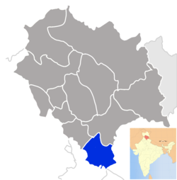
| Location of Sirmour district in Himachal Pradesh | |
| Country | India |
| State | Himachal Pradesh |
| Established | |
| Headquarters | Nahan |
| Area | |
| • Total | 2,825 km2 (1,091 sq mi) |
| Population (2001) | |
| • Total | 4,58,593 |
| • Density | 160/km2 (420/sq mi) |
| Demographics | |
| • Literacy | 70.85% |
| • Sex ratio | 900.5 |
| Website | Official website |
Sirmour is the most south-eastern district of Himachal Pradesh, India. It is largely mountainous and rural, with 90% of its population living in villages. It includes the towns of Nahan (its capital), as well as the Shivalik Fossil Park at Suketi, where fossils of over 85 million years old have been found.
There are six tehsils in this district, namely Nahan, Renuka, Shilai, Rajgarh, Pachhad and Paonta Sahib.
Agriculture is the backbone of economy here. Farmers of Sirmour produce potato and ginger. Sirmour is also known for its good quality of peach that comes from the Rajgarh region which is also called the Peach Bowl. Sirmour is known for growing tons of fruits every year. Dhaula Kuan near Paonta Sahib is known for its Govt operated fruit research centre. Sirmour district is significantly capable of growing both Apple and Mangos on its land. Tomato is also becoming choice for farmers these days. Village Lana-cheta is known for its fertile land and farmers here grow grains as first option. The Giri River divides the district into two almost-equal parts: Giripar and Giriwar.
The most commonly practised religion in the district is Hinduism. People worship deities (devtas) just like people in many other districts of the state. Hindi and Pahari are the languages spoken here. Nati is the popular folk dance.
History[]
Sirmour was an independent kingdom in India, founded in 1616 by Raja Rasaloo of Jaisalmer whose one of the ancestor's name was Sirmour. It became a part of Greater Nepal, before becoming a princely state in British India, located in the region that is now the Sirmour district of Himachal Pradesh. The state was also known as Nahan, after its main city, Nahan. Sirmur was ruled by the chiefs of Rajput lineage, who used the title "Raja".
Economy[]
In 2006 the Ministry of Panchayati Raj named Sirmaur one of the country's 250 most backward districts (out of a total of 640).[1] It is one of the two districts in Himachal Pradesh currently receiving funds from the Backward Regions Grant Fund Programme (BRGF).[1] Kamrao is small village also known as "place of limestone millionaires".Sataun is the largest limestone market of SE Asia.
Demographics[]
According to the 2011 census Sirmaur district has a population of 530,164,[2] roughly equal to the nation of Cape Verde.[3] This gives it a ranking of 542nd in India (out of a total of 640).[2] The district has a population density of 188 inhabitants per square kilometre (490 /sq mi) .[2] Its population growth rate over the decade 2001-2011 was 15.61 %.[2] Sirmaur has a sex ratio of 915 females for every 1000 males,[2] and a literacy rate of 79.98 %.[2]
See also[]
- The Sirmoor Rifles
References[]
- ^ a b Ministry of Panchayati Raj (September 8, 2009). "A Note on the Backward Regions Grant Fund Programme". National Institute of Rural Development. http://www.nird.org.in/brgf/doc/brgf_BackgroundNote.pdf. Retrieved September 27, 2011.
- ^ a b c d e f "District Census 2011". Census2011.co.in. 2011. http://www.census2011.co.in/district.php. Retrieved 2011-09-30.
- ^ US Directorate of Intelligence. "Country Comparison:Population". https://www.cia.gov/library/publications/the-world-factbook/rankorder/2119rank.html. Retrieved 2011-10-01. "Cape Verde 516,100 July 2011 est."
External links[]
- DISTRICT PROFILE
- CULTURAL & TOURISM HERITAGE OF THE DISTRICT
- Sirmour at a glance
- History of Sirmour
- Information about Sirmour District and its various places

|
Solan district | Shimla district | 
| |
| Panchkula district, Haryana | Dehradun district, Uttarakhand | |||
 Sirmaur district | ||||
| Ambala district, Haryana | Yamunanagar district, Haryana | Saharanpur district, Uttar Pradesh |
| |||||
| Lakes | Renuka Lake | Maharana Pratap Sagar | Gobind Sagar (more...) |
|---|---|
| Rivers | Beas | Chenab | Ravi | Sutlej | Yamuna |
| Districts | Bilaspur | Chamba | Hamirpur | Kangra | Kinnaur | Kullu | Lahul and Spiti | Mandi | Sirmaur | Shimla | Solan | Una |
| Other | Climate of Himachal Pradesh | Protected areas of Himachal Pradesh | List of peaks in Himachal Pradesh |
| This page uses content from the English language Wikipedia. The original content was at Sirmaur district. The list of authors can be seen in the page history. As with this Familypedia wiki, the content of Wikipedia is available under the Creative Commons License. |
