| ||||||||||||||
| Searcy County, Arkansas | |
 Searcy County Courthouse
| |
 Location in the state of Arkansas | |
 Arkansas's location in the U.S. | |
| Founded | December 13, 1838 |
|---|---|
| Seat | Marshall |
| Largest city | Marshall |
| Area - Total - Land - Water |
669 sq mi (1,733 km²) 666 sq mi (1,725 km²) 2.4 sq mi (6 km²), 0.4% |
| PopulationEst. - (2015) - Density |
7,869 12/sq mi (5/km²) |
| Congressional districts | 1st, 3rd |
| Time zone | Central: UTC-6/-5 |
Searcy County is a county located in the U.S. state of Arkansas. As of the 2010 census, the population was 8,195.[1] The county seat is Marshall.[2] The county was formed December 13, 1838, from a portion of Marion County and named for Richard Searcy, the first clerk and judge in the Arkansas Territory. The city of Searcy, Arkansas, some seventy miles away, shares the name despite having never been part of Searcy County. The county is an alcohol prohibition or dry county.
Geography
According to the U.S. Census Bureau, the county has a total area of 669 square miles (1,730 km2), of which 666 square miles (1,720 km2) is land and 2.4 square miles (6.2 km2) (0.4%) is water.[3]
Major highways
 U.S. Highway 65
- Arkansas Highway 14
- Arkansas Highway 16
- Arkansas Highway 27
- Arkansas Highway 66
- Arkansas Highway 74
- Arkansas Highway 235
- Arkansas Highway 333
- Arkansas Highway 374
- Arkansas Highway 377
Adjacent counties
- Marion County (north)
- Baxter County (northeast)
- Stone County (east)
- Van Buren County (south)
- Pope County (southwest)
- Newton County (west)
- Boone County (northwest)
National protected areas
- Buffalo National River (part)
- Ozark National Forest (part)
Demographics
| Historical populations | |||
|---|---|---|---|
| Census | Pop. | %± | |
| 1840 | 936 | ||
| 1850 | 1,979 | 111.4% | |
| 1860 | 5,271 | 166.3% | |
| 1870 | 5,614 | 6.5% | |
| 1880 | 7,278 | 29.6% | |
| 1890 | 9,664 | 32.8% | |
| 1900 | 11,988 | 24.0% | |
| 1910 | 14,825 | 23.7% | |
| 1920 | 14,590 | −1.6% | |
| 1930 | 11,056 | −24.2% | |
| 1940 | 11,942 | 8.0% | |
| 1950 | 10,424 | −12.7% | |
| 1960 | 8,124 | −22.1% | |
| 1970 | 7,731 | −4.8% | |
| 1980 | 8,847 | 14.4% | |
| 1990 | 7,841 | −11.4% | |
| 2000 | 8,261 | 5.4% | |
| 2010 | 8,195 | −0.8% | |
| Est. 2015 | 7,869 | [4] | −4.7% |
| U.S. Decennial Census[5] 1790–1960[6] 1900–1990[7] 1990–2000[8] 2010–2015[1] | |||

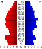
Age pyramid Searcy County[9]
As of the 2000 United States Census,[10] there were 8,261 people, 3,523 households, and 2,466 families residing in the county. The population density was 12 people per square mile (5/km²). There were 4,292 housing units at an average density of 6 per square mile (2/km²). The racial makeup of the county was 97.26% White, 0.04% Black or African American, 0.75% Native American, 0.15% Asian, 0.01% Pacific Islander, 0.45% from other races, and 1.34% from two or more races. 1.04% of the population were Hispanic or Latino of any race.
There were 3,523 households out of which 27.90% had children under the age of 18 living with them, 58.50% were married couples living together, 7.70% had a female householder with no husband present, and 30.00% were non-families. 28.00% of all households were made up of individuals and 14.30% had someone living alone who was 65 years of age or older. The average household size was 2.33 and the average family size was 2.83.
In the county the population was spread out with 22.70% under the age of 18, 6.90% from 18 to 24, 24.50% from 25 to 44, 26.70% from 45 to 64, and 19.20% who were 65 years of age or older. The median age was 42 years. For every 100 females there were 98.00 males. For every 100 females age 18 and over, there were 94.80 males.
The median income for a household in the county was $21,397, and the median income for a family was $27,580. Males had a median income of $21,768 versus $16,276 for females. The per capita income for the county was $12,536. About 17.80% of families and 23.80% of the population were below the poverty line, including 31.00% of those under age 18 and 26.60% of those age 65 or over.
Government and politics
Searcy is among the northwestern Arkansas counties that have been traditionally Republican in political leanings. In Presidential elections since World War II Jimmy Carter was the only Democrat to carry the county.[11] It was one of the only counties in Arkansas to be won by Alf Landon.[12] In the 1992 election George H. W. Bush won his second-highest margin in the state, and the Republican nominee has received over 60 percent in Presidential elections from 2000 to 2012 inclusive.[13] In 2012, Searcy County voted over 73 percent for Mitt Romney, while President Barack Obama received just 22 percent.
The county is in Arkansas's 1st congressional district, which from Reconstruction until 2010 sent only Democrats to the U.S. House. That year, it elected Republican Rick Crawford, who currently holds the seat as of 2014. In the Arkansas House of Representatives Searcy County is represented by second-term Republican David Branscum from the 83rd (and formerly the 90th prior to 2013) district.[14] The state senator, Missy Thomas Irvin, is also a Republican, serving her second term from the 18th district.[15]
Since 1980, in gubernatorial races, the county has tended to favor Republicans in all but one contest. It voted for Frank White in his successful run against freshman Democrat incumbent Bill Clinton in 1980. It supported White again in 1982 and 1986 in rematches with Clinton. It also voted for Woody Freeman over Clinton in 1984. It was the only county in Arkansas where Republican Sheffield Nelson won in both 1990 and 1994.[16] In 1990, it was Nelson's best county in the entire state, winning 64 percent to then-Governor Bill Clinton's 36 percent in Searcy County. In 1994, Searcy County was among the two counties to vote for Nelson over incumbent Democrat Jim Guy Tucker, Benton County being the other (which actually voted for Clinton over Nelson in 1990).
In 1998, Searcy County voted for Republican Mike Huckabee with just under 70 percent, and again in 2002, albeit with a reduced margin of 57 percent. In 2006, it voted 52 percent for Republican ex-Congressman Asa Hutchinson, who lost to Democrat Mike Beebe. In 2010, however, it did vote for incumbent Democrat Mike Beebe with a margin of 57 percent to 40 percent over former state Senator Jim Keet, the first time it had done so since 1978. Keet was regarded as a weak candidate, as he failed to carry a single county.
See also Winston County, Alabama.
Education
Public education is provided for early childhood, elementary and secondary education from multiple school districts including:
- Searcy County School District, which includes Marshall High School
- Ozark Mountain School District, which includes Searcy County-based St. Joe High School and St. Joe Elementary School.
Communities
Cities
- Leslie
- Marshall (county seat)
Towns
- Gilbert
- Pindall
- St. Joe
Townships


Townships in Searcy County, Arkansas as of 2010
Townships in Arkansas are the divisions of a county. Each township includes unincorporated areas and some may have incorporated towns or cities within part of their space. Townships have limited purposes in modern times. However, the US Census does list Arkansas population based on townships (often referred to as "minor civil divisions"). Townships are also of value for historical purposes in terms of genealogical research. Each town or city is within one or more townships in an Arkansas county based on census maps. The townships of Searcy County are listed below with the town(s) and/or city that are fully or partially inside them listed in parentheses.
| Township | FIPS code | ANSI code (GNIS ID) |
Population center(s) |
Pop. (2010) |
Pop. density (/mi²) |
Pop. density (/km²) |
Land area (mi²) |
Land area (km²) |
Water area (mi²) |
Water area (km²) |
Geographic coordinates |
|---|---|---|---|---|---|---|---|---|---|---|---|
| Bear Creek No. 4 | 05-90177 | 02406938 | Marshall | 989 | 21.20 | 8.18 | 46.655 | 120.8 | 0.174 | 0.4507 | |
| Bear Creek No. 5 | 05-90178 | 02406939 | Marshall | 728 | 492.22 | 190.08 | 1.479 | 3.831 | 0.002 | 0.005180 | |
| Bear Creek No. 6 | 05-90179 | 02406940 | Marshall | 913 | 36.64 | 14.15 | 24.917 | 64.53 | 0.096 | 0.2486 | |
| Calf Creek | 05-90708 | 00066892 | 326 | 4.01 | 1.55 | 81.202 | 210.3 | 0.514 | 1.331 | ||
| Long Creek | 05-92274 | 00069086 | 474 | 10.72 | 4.14 | 44.219 | 114.5 | 0.060 | 0.1554 | ||
| Mount Pleasant | 05-90981 | 00066895 | 465 | 4.28 | 1.65 | 108.750 | 281.7 | 0.248 | 0.6423 | ||
| Oxley | 05-92801 | 02407397 | 364 | 11.37 | 4.39 | 32.018 | 82.93 | 0.027 | 0.06993 | ||
| Prairie | 05-93012 | 00069090 | Pindall | 550 | 13.82 | 5.34 | 39.793 | 103.1 | 0.018 | 0.04662 | |
| Red River | 05-93087 | 00069091 | 321 | 9.69 | 3.78 | 33.144 | 85.84 | 0.064 | 0.1658 | ||
| Rock Creek | 05-93213 | 00069093 | 547 | 10.48 | 3.99 | 52.915 | 137.0 | 0.097 | 0.2512 | ||
| St. Joe | 05-93279 | 00069094 | St. Joe | 390 | 13.07 | 5.05 | 29.838 | 77.28 | 0.239 | 0.6190 | |
| Shady Grove | 05-93351 | 00069095 | 189 | 4.41 | 2.87 | 42.834 | 110.9 | 0.971 | 2.515 | ||
| Spring | 05-93456 | 00069096 | Marshall | 588 | 12.59 | 4.86 | 46.715 | 121.0 | 0.227 | 0.5879 | |
| Tomahawk | 05-93618 | 00069098 | Gilbert, St. Joe | 574 | 10.68 | 4.12 | 53.762 | 139.2 | 0.421 | 1.090 | |
| Wileys Cove | 05-94062 | 00069099 | Leslie | 777 | 17.18 | 6.63 | 45.225 | 117.1 | 0.210 | 0.5439 | |
| Source: U.S. Census Bureau[19][20] | |||||||||||
See also
- National Register of Historic Places listings in Searcy County, Arkansas
References
- ^ a b "State & County QuickFacts". United States Census Bureau. http://quickfacts.census.gov/qfd/states/05/05129.html. Retrieved May 19, 2014.
- ^ "Find a County". National Association of Counties. http://www.naco.org/Counties/Pages/FindACounty.aspx. Retrieved 2011-06-07.
- ^ "2010 Census Gazetteer Files". United States Census Bureau. August 22, 2012. http://www2.census.gov/geo/docs/maps-data/data/gazetteer/counties_list_05.txt. Retrieved August 27, 2015.
- ^ "County Totals Dataset: Population, Population Change and Estimated Components of Population Change: April 1, 2010 to July 1, 2015". http://www.census.gov/popest/data/counties/totals/2015/CO-EST2015-alldata.html. Retrieved July 2, 2016.
- ^ "U.S. Decennial Census". United States Census Bureau. http://www.census.gov/prod/www/decennial.html. Retrieved August 27, 2015.
- ^ "Historical Census Browser". University of Virginia Library. http://mapserver.lib.virginia.edu. Retrieved August 27, 2015.
- ^ Forstall, Richard L., ed (March 27, 1995). "Population of Counties by Decennial Census: 1900 to 1990". United States Census Bureau. http://www.census.gov/population/cencounts/ar190090.txt. Retrieved August 27, 2015.
- ^ "Census 2000 PHC-T-4. Ranking Tables for Counties: 1990 and 2000". United States Census Bureau. April 2, 2001. http://www.census.gov/population/www/cen2000/briefs/phc-t4/tables/tab02.pdf. Retrieved August 27, 2015.
- ^ Based on 2000 census data
- ^ "American FactFinder". United States Census Bureau. http://factfinder2.census.gov. Retrieved 2011-05-14.
- ^ David Leip's Election Atlas (Electoral Maps for Arkansas by year)
- ^ Geographie Electorale
- ^ The New York Times electoral map (Zoom in on Arkansas)
- ^ Arkansas House page
- ^ Arkansas Senate site
- ^ David Leip's Election Atlas (Gubernatorial electoral Maps for Arkansas by year)
- ^ U. S. Census Bureau. 2011 Boundary and Annexation Survey (BAS): Searcy County, AR (Map). http://www2.census.gov/geo/pvs/bas/bas11/st05_ar/cou/c05129_searcy/BAS11C20512900000_000.pdf. Retrieved 2011-07-26.
- ^ "Arkansas: 2010 Census Block Maps - County Subdivision". United States Census Bureau. http://www.census.gov/geo/maps-data/maps/block/2010/cousub/dc10blk_st05_cousub.html#S. Retrieved June 28, 2014.
- ^ "County Subdivisions: Arkansas" (TXT). Census 2010 U.S. Gazetteer Files. United States Census Bureau. http://www.census.gov/geo/maps-data/data/docs/gazetteer/county_sub_list_05.txt.
- ^ "Census 2010 U.S. Gazetteer Files". United States Census Bureau. http://www.census.gov/geo/maps-data/data/gazetteer2010.html.
External links
- Searcy County Arkansas Chamber of Commerce
- Searcy County Library (extensive local genealogy records and fulltime genealogy staff)
- Searcy County entry in the Encyclopedia of Arkansas
- Searcy County Map from Encyclopedia of Arkansas
- Searcy County Map from U. S. Census Bureau

|
Boone County | Marion County | Baxter County |
|
| Newton County | Stone County | |||
 Searcy County, Arkansas | ||||
| Pope County | Van Buren County |
| |||||||||||||||||||||||

| This page uses content from the English language Wikipedia. The original content was at Searcy County, Arkansas. The list of authors can be seen in the page history. As with this Familypedia wiki, the content of Wikipedia is available under the Creative Commons License. |