| Main | Births etc |
|---|
| Scottish Borders The Mairches Na Crìochan |
|
|---|---|
 |
|
| Coordinates: Coordinates: | |
| Admin HQ | Newtown St Boswells |
| Government | |
| • Body | Scottish Borders Council |
| • Control | Conservative/Independent/Liberal Democrat) |
| • MPs | *Michael Moore
|
| • MSPs | *Christine Grahame
|
| Area | |
| • Total | 1,831.15 sq mi (4,742.65 km2) |
| Area rank | Ranked 6th |
| Population (2010 est.) | |
| • Total | 110,200 |
| • Rank | Ranked 18th |
| • Density | 60/sq mi (23/km2) |
| ONS code | 00QE |
| ISO 3166 code | GB-SCB |
| Website | http://www.scotborders.gov.uk/ |
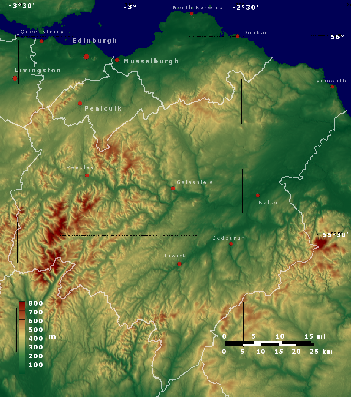
Topographic map of Scottish Borders and Lothian
The Scottish Borders (Scots: The Mairches) is one of 32 council areas of Scotland.[1] It is bordered by Dumfries and Galloway to the west, South Lanarkshire and West Lothian to the north west, the City of Edinburgh, East Lothian and Midlothian to the north; and the non-metropolitan counties of Cumbria and Northumberland in England to the south and east. The administrative centre of the area is Newtown St. Boswells.
Historically, the name Scottish Borders designated the entire border region of southern Scotland and, together with neighbouring areas of England, was part of the historical Borders region.
Geography[]
The Scottish Borders are located in the eastern part of the Southern Uplands.[2]
The region is hilly and largely rural, with the River Tweed flowing west to east through the region. In the east of the region the area that borders the River Tweed is flat and is known as 'The Merse'. The Tweed and its tributaries drain the entire region with the river flowing into the North Sea at Berwick-upon-Tweed, and forming the border with England for the last twenty miles or so of its length.
The term Central Borders refers to the area in which the majority of the main towns of Galashiels, Selkirk, Hawick, Jedburgh, Earlston, Kelso, Newtown St. Boswells, St Boswells, Peebles, Melrose and Tweedbank are located.
History[]
Historically, the term Borders has a wider meaning, referring to all of the burghs adjoining the English border, also including Dumfriesshire and Kirkcudbrightshire — as well as Northumberland, Cumberland and Westmorland in England.
Roxburghshire and Berwickshire historically bore the brunt of the conflicts with England, both during declared wars such as the Wars of Scottish Independence, and armed raids which took place in the times of the Border Reivers. Thus, across the region are to be seen the ruins of many castles, abbeys and even towns.
The council area was created in 1975, by merging the former counties of Berwickshire, Peeblesshire, Roxburghshire, and Selkirkshire and part of Midlothian, as a two-tier region with the districts of Berwickshire, Ettrick and Lauderdale, Roxburgh, and Tweeddale within it. In 1996 the region became a unitary authority area and the districts were wound up. The region was created with the name Borders. Following the election of a shadow area council in 1995 the name was changed to Scottish Borders with effect from 1996.[3]
Although there is evidence of some Scottish Gaelic in the origins of place names such as Innerleithen ("confluence of the Leithen"), Kilbucho and Longformacus, which contain identifiably Goidelic rather than Brythonic Celtic elements, the language has tended to be weak to non-existent in most parts of the region. Since the 5th century, there has been evidence of two main languages in the area: Brythonic (in the west) and Old English (in the east), the latter of which developed into its modern forms of English and Scots.
Politics[]
There are two British Parliamentary constituencies in the Borders. Berwickshire, Roxburgh and Selkirk covers most of the region and is represented by Liberal Democrat Michael Moore. The western Tweeddale area is included in the Dumfriesshire, Clydesdale & Tweeddale constituency and is represented by Conservative David Mundell.
At Scottish Parliament level, there are also two seats. The eastern constituency is Roxburgh & Berwickshire, which is currently represented by Conservative John Lamont. The western constituency is Tweeddale, Ettrick & Lauderdale and is represented by SNP Christine Grahame.
Following the 2012 local elections, the council administration is now a coalition of Independents, Scottish National Party and Liberal Democrats. Prior to the election a coalition of Conservatives, Liberal Democrats and Independents ruled. The Conservatives are the biggest party on the council with 10 seats, the Liberal Democrats have six. The SNP have nine seats and the Independents have seven. Two councillors form the Borders Party.
| Political party | Seats | |
|---|---|---|
| Scottish Conservative Party | 10 | |
| • | Scottish National Party | 9 |
| • | Independent | 7 |
| • | Scottish Liberal Democrats | 6 |
| Borders Party | 2 | |
Population[]
At the Census held on 27 March 2011, the population of the region was 114,000 (provisional total), an increase of 6.78% from the 106,764 enumerated at the previous (2001) Census.
Transport[]
The region has no working railway stations. Although the area was well connected to the Victorian railway system, the branch lines that supplied it were closed in the decades following the Second World War. A bill has been passed by the Scottish Parliament to extend the Waverley Line, which would be a commuter service from Edinburgh to Stow, Galashiels and Tweedbank. Today, the East Coast Main Line is the only railway which runs through the region, with Edinburgh Waverley, Dunbar and Berwick being the nearest stations on that line, all of which are outwith the Borders. To the west, Carlisle, Carstairs and Lockerbie on the West Coast Main Line are the nearest.
The area is served by buses, which connect the main population centres. Express bus services link the main towns with rail stations at Edinburgh and Carlisle.
The region also has no commercial airports; the nearest are Edinburgh and Newcastle, both of which are international airports.
The main roads to and from the region are:
- The A1, which runs along the east coast from London to Edinburgh; passing near Eyemouth.
- The A7 which runs north to south from Edinburgh to Carlisle and the M6; passing through Galashiels, Selkirk and Hawick.
- The A68 running from Darlington to Edinburgh; passing through Jedburgh, Newtown St. Boswells, Earlston and Lauder.
- The A72, which runs east to west from Galashiels to Hamilton; passing through Innerleithen and Peebles
Surnames[]
The surname Hetherington/Heatherington is based and originated on the borders of Scotland, Strathclyde, Dumfries and Fife.
Towns and villages[]

Part of the Scottish Borders Council offices at Newtown St. Boswells
- Abbey St. Bathans, Allanton, Ancrum, Ashkirk
- Broughton, Burnmouth
- Cardrona, Chirnside, Clovenfords, Cockburnspath, Coldingham, Coldstream
- Denholm, Dryburgh, Duns
- Earlston, Edrom, Eddleston, Ettrick, Ettrickbridge, Eyemouth
- Foulden
- Galashiels, Grantshouse, Greenlaw
- Hawick, Heriot, Hutton
- Innerleithen
- Jedburgh
- Kelso, Kirk Yetholm
- Lauder, Lilliesleaf, Longformacus
- Melrose
- Newcastleton, Newstead, Newtown St. Boswells
- Peebles, Preston
- Roxburgh
- Selkirk, St. Abbs, St. Boswells, Stow, Stichill
- Teviothead, Town Yetholm, Traquair, Tweedbank, Tweedsmuir
- Walkerburn, West Linton, Whitsome
- Yair
Places of interest[]
- Abbotsford House
- Bowhill House
- Cheviot Hills
- Cessford Burn
- Coldingham Bay
- Dawyck Botanic Garden
- Dryburgh Abbey - Historic Scotland
- Duns Castle
- Edin's Hall Broch
- Ettrick Forest
- Eyemouth
- Floors Castle
- Glentress Forest - Forest Enterprise
- Greenknowe Tower
- Harmony Garden - National Trust for Scotland
- Hawkshaw - ancestral home of the Porteous family
- Hermitage Castle - Historic Scotland
- Jedburgh Abbey - Historic Scotland
- Kailzie Gardens
- Kelso Abbey
- Lammermuir Hills
- Lauderdale
- Manderston
- Megget Reservoir
- Mellerstain House
- Melrose Abbey - Historic Scotland
- Mire Loch
- Monteviot
- Neidpath Castle
- Nisbet, Berwickshire
- Nisbet, Roxburghshire
- Paxton House
- Pennine Way - National Trails
- Priorwood Garden - National Trust for Scotland
- Robert Smail's Printing Works - National Trust for Scotland
- Scots' dike
- Smailholm Tower - Historic Scotland
- Southern Upland Way - National Trails
- St. Abbs Head
- St. Mary's Loch
- St. Ronans Wells
- Teviotdale
- Thirlestane Castle
- Traquair House
- Trimontium
- Waterloo Monument
- Wedderburn Castle
Notes and references[]
- ^ Local councils of Scotland, Directgov website
- ^ Visit Southern Scotland
- ^ Notice of change of name of local authority area, Edinburgh Gazette, 26 May 1995
See also[]
- Scottish Marches
- Anglo-Scottish border
- Debatable lands
- List of places in the Scottish Borders
- Scottish Lowlands
- Alexander Jeffrey, historian of Scottish Borders
External links[]
- Scottish Borders at the Open Directory Project
- Borders' Dialect
- Scots Language Centre page on Borders' Dialect
- Scottish Borders Council
| |||||
Template:Former local government regions of Scotland
| This page uses content from the English language Wikipedia. The original content was at Scottish Borders. The list of authors can be seen in the page history. As with this Familypedia wiki, the content of Wikipedia is available under the Creative Commons License. |