| ||||||||||||||
| Scott County, Kansas | |
 Location in the state of Kansas | |
 Kansas's location in the U.S. | |
| Founded | March 20, 1873 |
|---|---|
| Seat | Scott City |
| Area - Total - Land - Water |
717.64 sq mi (1,859 km²) 717.52 sq mi (1,858 km²) 0.12 sq mi (0 km²), 0.02% |
| Population - (2010) - Density |
4,936 6.4/sq mi (2.5/km²) |
| Time zone | Central: UTC-6/-5 |
Scott County (standard abbreviation: SC) is a county located in the U.S. state of Kansas. As of the 2010 census, the county population was 4,936.[1] Its county seat is Scott City, the only city in the county.
Law and government[]
Although the Kansas Constitution was amended in 1986 to allow the sale of alcoholic liquor by the individual drink with the approval of voters, Scott County has remained a prohibition, or "dry", county.[2] Alcohol is only sold in liquor stores, with 3.2% cereal-malt beverages available in grocery stores.
Geography[]
According to the 2000 census, the county has a total area of 717.64 square miles (1,858.7 km2), of which 717.52 square miles (1,858.4 km2) (or 99.98%) is land and 0.12 square miles (0.31 km2) (or 0.02%) is water.[3]
Adjacent counties[]
- Gove County (northeast)
- Lane County (east)
- Finney County (south)
- Kearny County (southwest)
- Wichita County (west)
- Logan County (northwest)
Demographics[]
| Historical populations | |||
|---|---|---|---|
| Census | Pop. | %± | |
| 1900 | 1,098 | ||
| 1910 | 3,047 | 177.5% | |
| 1920 | 3,121 | 2.4% | |
| 1930 | 3,976 | 27.4% | |
| 1940 | 3,773 | −5.1% | |
| 1950 | 4,921 | 30.4% | |
| 1960 | 5,228 | 6.2% | |
| 1970 | 5,606 | 7.2% | |
| 1980 | 5,782 | 3.1% | |
| 1990 | 5,289 | −8.5% | |
| 2000 | 5,120 | −3.2% | |
| 2010 | 4,936 | −3.6% | |

Age pyramid
As of the census[4] of 2000, there were 5,120 people, 2,045 households, and 1,435 families residing in the county. The population density was 7 people per square mile (3/km²). There were 2,291 housing units at an average density of 3 per square mile (1/km²). The racial makeup of the county was 95.47% White, 0.10% Black or African American, 0.55% Native American, 0.12% Asian, 2.75% from other races, and 1.02% from two or more races. 6.31% of the population were Hispanic or Latino of any race.
There were 2,045 households out of which 33.30% had children under the age of 18 living with them, 61.00% were married couples living together, 6.70% had a female householder with no husband present, and 29.80% were non-families. 27.30% of all households were made up of individuals and 13.60% had someone living alone who was 65 years of age or older. The average household size was 2.46 and the average family size was 3.01.
In the county the population was spread out with 27.10% under the age of 18, 6.60% from 18 to 24, 25.30% from 25 to 44, 24.40% from 45 to 64, and 16.50% who were 65 years of age or older. The median age was 39 years. For every 100 females there were 97.10 males. For every 100 females age 18 and over, there were 94.40 males.
The median income for a household in the county was $40,534, and the median income for a family was $50,549. Males had a median income of $32,166 versus $20,221 for females. The per capita income for the county was $20,443. About 2.10% of families and 5.10% of the population were below the poverty line, including 6.00% of those under age 18 and 8.10% of those age 65 or over.
Cities and towns[]
Incorporated cities[]
Name and population (2004 estimate):
- Scott City, 3,545 (county seat)
Unincorporated places[]
- Chevron
- Grigston
- Hutchins
- Manning
- Modoc
- Pence
- Shallow Water
- Tractor
Townships[]
Scott County is divided into seven townships. Scott City is considered governmentally independent and is excluded from the census figures for the townships. In the following table, the population center is the largest city (or cities) included in that township's population total, if it is of a significant size.
| Township | FIPS | Population center |
Population | Population density /km² (/sq mi) |
Land area km² (sq mi) |
Water area km² (sq mi) |
Water % | Geographic coordinates |
|---|---|---|---|---|---|---|---|---|
| Beaver | 05175 | 302 | 1 (3) | 309 (119) | 0 (0) | 0.10% | ||
| Isbel | 34575 | 110 | 1 (1) | 206 (80) | 0 (0) | 0 % | ||
| Keystone | 36600 | 106 | 1 (1) | 206 (80) | 0 (0) | 0 % | ||
| Lake | 37850 | 95 | 0 (1) | 311 (120) | 0 (0) | 0 % | ||
| Michigan | 46175 | 88 | 0 (1) | 308 (119) | 0 (0) | 0 % | ||
| Scott | 63575 | 309 | 2 (4) | 202 (78) | 0 (0) | 0 % | ||
| Valley | 73125 | 255 | 1 (2) | 311 (120) | 0 (0) | 0 % |
Education[]
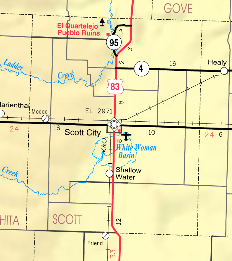
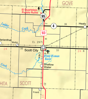
2005 KDOT Map of Scott County (map legend)
Unified school districts[]
- Scott County USD 466
Public Library[]
The Scott County Public Library is located at 110 West 8th in Scott City, Kansas. The Scott County Library was the first FREE county public library in the state of Kansas. It was started in September of 1923 with the five members of the library committee each checking out a book for herself and one for her husband thus the library checked out 10 books on the first day that it was open. Two rooms on the second floor of the Cretcher Lumber Company office building were made available for the Library. L.W. Cretcher, owner of the lumber yard, gave the Library a boost by painting the rooms, furnishing a stove, shelves , cupboards, lights, coat and free rent. In November of the following year a proposal was put on the ballot for the Library to be a county funded entity. A room was set aside in the basement of the newly built courthouse for the Library, which at that time possessed 861 books. The Library in the Court House was opened to the public in July of 1925. The Library remained in the basement of the Scott County Courthouse until a Library building was constructed at 110 West 8th Street in 1964. This building was 4,150 square feet (386 m2) with a 660-square-foot (61 m2) meeting room available to the public. In 2004, the Scott County Library Board began a fundraising effort for a Library Building expansion of 7,350 feet (2,240 m). The Library expansion and remodel to 12,160 square feet (1,130 m2) was completed in May of 2009. (History of Early Scott County, Scott County Historical Society, 1977. pp. 306-307)
See also[]
Information on this and other counties in Kansas
- List of counties in Kansas
- List of Kansas county name etymologies
- National Register of Historic Places listings in Kansas
- Kansas locations by per capita income
Other information for Kansas
- List of cities in Kansas
- List of unified school districts in Kansas
- List of colleges and universities in Kansas
References[]
- ^ "2010 County Population and Housing Occupancy Status". U.S. Census Bureau. http://factfinder2.census.gov/faces/tableservices/jsf/pages/productview.xhtml?pid=DEC_10_PL_GCTPL2.ST05&prodType=table. Retrieved April 6, 2011.
- ^ "Map of Wet and Dry Counties". Alcoholic Beverage Control, Kansas Department of Revenue. November 2004. http://www.ksrevenue.org/abcwetdrymap.htm. Retrieved 2007-01-21.
- ^ "Census 2000 U.S. Gazetteer Files: Counties". United States Census. http://www.census.gov/tiger/tms/gazetteer/county2k.txt. Retrieved 2011-02-13.
- ^ "American FactFinder". United States Census Bureau. http://factfinder.census.gov. Retrieved 2008-01-31.
Further reading[]
- History of the State of Kansas; William G. Cutler; A.T. Andreas Publisher; 1883. (Online HTML eBook)
- Kansas : A Cyclopedia of State History, Embracing Events, Institutions, Industries, Counties, Cities, Towns, Prominent Persons, Etc; 3 Volumes; Frank W. Blackmar; Standard Publishing Co; 944 / 955 / 824 pages; 1912. (Volume1 - Download 54MB PDF eBook),(Volume2 - Download 53MB PDF eBook), (Volume3 - Download 33MB PDF eBook)
External links[]
- Official
- Other County Websites
- Maps
- 2009 Scott County Map, KDOT
- 2011 Kansas Highway Map, KDOT
- 2011 Kansas Railroad Map, KDOT
- 2005 Kansas School District Boundary Map, KSDE

|
Logan County | Gove County |
| |
| Wichita County | Lane County | |||
 Scott County, Kansas | ||||
| Kearny County | Finney County | Finney County |
| |||||
| This page uses content from the English language Wikipedia. The original content was at Scott County, Kansas. The list of authors can be seen in the page history. As with this Familypedia wiki, the content of Wikipedia is available under the Creative Commons License. |