| San Francisco Bay Area | |
|---|---|
| — Conurbation — | |
 |
|
 The nine-county Bay Area. Additional counties in the larger twelve-county CSA. |
|
| Country | |
| State | |
| Subregions |
|
| Principal cities | |
| Area[1] | |
| • Nine-county | 6,966 sq mi (18,040 km2) |
| • CSA | 10,191 sq mi (26,390 km2) |
| Highest elevation[2] Copernicus Peak |
4,360 ft (1,330 m) |
| Lowest elevation[3] Alviso |
−13 ft (−4.0 m) |
| Population (2017) | |
| • Nine-county | 7.76 million[4] |
| • Nine-county Density | 1,102.5/sq mi (425.7/km2) |
| • CSA | 8.84 million[5] |
| • CSA Density | 859/sq mi (332/km2) |
| Time zone | Pacific (UTC−8) |
| • Summer (DST) | PDT (UTC−7) |
| Area codes | 408/669, 415/628, 510/341, 650, 707, 925[6] |
The San Francisco Bay Area (popularly referred to as the Bay Area) is a populous region surrounding the San Francisco, San Pablo and Suisun estuaries in the northern part of the U.S. state of California. Although the exact boundaries of the region vary depending on the source, the Bay Area is generally accepted to include the nine counties that border the aforementioned estuaries: Alameda, Contra Costa, Marin, Napa, San Mateo, Santa Clara, Solano, Sonoma, and San Francisco. Other sources may exclude parts of or even entire counties, or expand the definition to include neighboring counties that don't border the bay such as San Benito, San Joaquin, and Santa Cruz.
Home to approximately 7.68 million people, Northern California’s nine-county Bay Area contains many cities, towns, airports, and associated regional, state, and national parks, connected by a complex multimodal transportation network. The larger combined statistical area of the region, which includes twelve counties, is the second-largest in California (after the Greater Los Angeles area), the fifth-largest in the United States, and the 41st-largest urban area in the world with 8.75 million people.[7] The Bay Area's population is ethnically diverse: for example, roughly half of the region's residents are Hispanic, Asian, African American, or Pacific Islander, all of whom have a significant presence throughout the region.
The earliest archaeological evidence of human settlements in the Bay Area dates back to 3000 BC. In 1769, the Bay Area was inhabited by the Ohlone people when a Spanish exploration party led by Gaspar de Portolà entered the Bay – the first documented European visit to the Bay Area. After Mexico established independence from Spain in 1821, the region was briefly controlled by the Mexican government until the United States seized the territory in 1846 during the Mexican–American War. Soon after, discovery of gold in California attracted a flood of treasure seekers, many using ports in the Bay Area as an entry point. During the early years of California's statehood, state legislative business rotated between three locations in the Bay Area before a permanent state capital was established in Sacramento. A major earthquake leveled the city of San Francisco and environs in 1906, but the region quickly rebuilt in time to host the 1915 Panama-Pacific Exposition. During World War II, the Bay Area played a major role in America's war effort in the Asiatic-Pacific Theater, with San Francisco's Fort Mason acting as a primary embarkation point for American forces. In 1945, the United Nations Charter was signed in San Francisco, establishing the United Nations, and in 1951, the Treaty of San Francisco officially ended the U.S.'s war with Japan. Since then, the Bay Area has experienced numerous political, cultural and artistic movements, developing unique local genres in music and art and establishing itself as a hotbed of progressive politics. Economically, the post-war Bay Area saw huge growth in the financial and technology industries, creating a vibrant and diverse economy with a gross domestic product of over $700 billion, and home to the second highest concentration of Fortune 500 companies in the United States.
Despite its urban character, the San Francisco Bay is one of California's most ecologically important habitats, providing key ecosystem services such as filtering pollutants and sediments from the rivers, and supporting a number of endangered species. The region is also known for the complexity of its landforms, the result of millions of years of tectonic plate movements. Because the Bay Area is crossed by six major earthquake faults, the region is particularly exposed to hazards presented by large earthquakes. The climate is temperate and generally very mild, and is ideal for outdoor recreational and athletic activities such as hiking. The Bay Area is host to seven professional sports teams and is a cultural center for music, theater, and the arts. It is also host to several institutions of higher education, ranging from primary schools to major research universities. Home to 101 municipalities and nine counties, governance in the Bay Area is multifaceted and involves numerous local and regional actors, each with wide-ranging and overlapping responsibilities.
Boundaries[]


A map of the locally accepted nine-county definition of the Bay Area. Also displayed are the five subregions of the Bay Area, which are divided along county lines except for the northwestern portion of Santa Clara county.
The borders of the San Francisco Bay Area are not officially delineated, and the unique development patterns influenced by the region's topography, along with the presence of unusual commute patterns caused by the presence of three central cities and employment centers located in suburban cities, has led to considerable disagreement between local and federal definitions of the area.[8] Because of this, professor of geography at the University of California, Berkeley Richard Walker claimed that "no other U.S. city-region is as definitionally challenged [as the Bay Area]."[8]
Locally, many of the regional governmental agencies and districts recognize the nine counties that border the San Francisco, San Pablo, and Suisun estuaries as part of the Bay Area: Alameda, Contra Costa, Marin, Napa, San Francisco, San Mateo, Santa Clara, Solano, and Sonoma counties. These agencies include the San Francisco Regional Water Quality Control Board,[9] Bay Area Air Quality Management District,[10] the San Francisco Bay Restoration Authority,[11] the Metropolitan Transportation Commission,[12] and the Association of Bay Area Governments,[13] the latter two of which partner to deliver a Bay Area Census using the nine-county definition.[14]
Various U.S. Federal government agencies use definitions that differ from their local counterparts' nine-county definition. For example, the Federal Communications Commission (FCC) which regulates broadcast, cable, and satellite transmissions, includes nearby Colusa, Lake and Mendocino counties in their "San Francisco-Oakland-San Jose" media market, but excludes eastern Solano county.[15] On the other hand, the United States Office of Management and Budget, which designates Metropolitan Statistical Areas (MSAs) and Combined Statistical Areas (CSA) for populated regions across the country, has five MSAs which include, wholly or partially, areas within the nine-county definition, and one CSA which includes all nine counties plus neighboring San Benito, Santa Cruz and San Joaquin counties.[16]
Subregions[]
Among locals, the nine-county Bay Area can be further divided into five sub-regions: the East Bay, North Bay, South Bay, Peninsula, and the city of San Francisco. Although geographically located on the tip of the San Francisco Peninsula, the city of San Francisco is not considered part of the "Peninsula" subregion, but as a separate entity.[17][18]
The "East Bay" is the densest region of the Bay Area outside of San Francisco and includes cities and towns in Alameda and Contra Costa counties, centered around Oakland. As one of the larger subregions, the East Bay includes a variety of enclaves, including the suburban Tri-Valley area and the highly urban western part of the subregion that runs alongside the bay.[19] The "Peninsula" subregion includes the cities and towns on the San Francisco Peninsula, excluding the titular city of San Francisco. Its eastern half, which runs alongside the Bay, is highly populated while its less populated western coast traces the coastline of the Pacific Ocean and is known for its open space and hiking trails. Roughly coinciding with the borders of San Mateo county, it also includes the northwestern Santa Clara county cities of Palo Alto, Mountain View, and Los Altos.[20] The "South Bay" includes all of the rest of the cities in Santa Clara county, centered around San Jose, the largest city in Northern California.[21] It is roughly synonymous with Silicon Valley due to its high concentration of tech companies, although the industry also has a significant presence in the rest of the Bay Area.[22] The "North Bay" includes Marin, Sonoma, Napa, and Solano counties, and is the largest and least populated subregion. The western counties of Marin and Sonoma are encased by the Pacific Ocean on the west and the bay on the east, and are characterized by its mountainous and woody terrain. Sonoma and Napa counties are known internationally for their grape vineyards and wineries, and Solano county to the east, centered around Vallejo, is the fastest growing region in the Bay Area.[23]
History[]

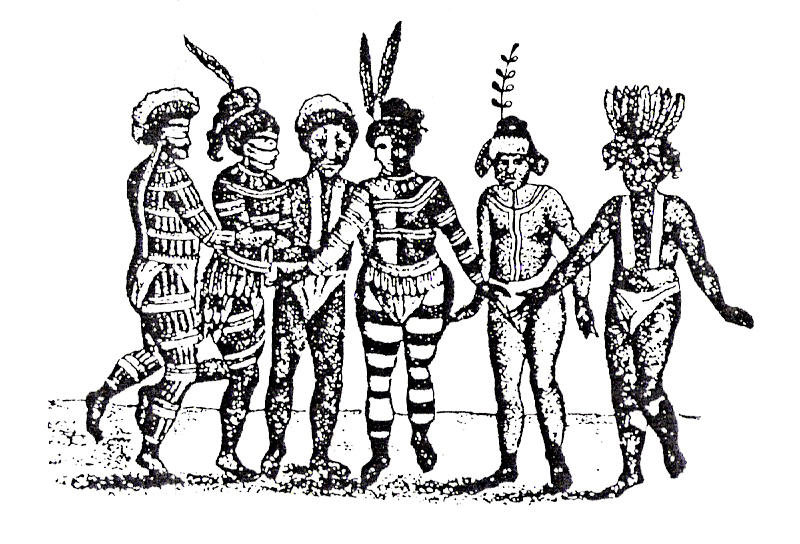
An early sketch of the Ohlone people dancing in Mission San Jose. The Ohlone lived in the Bay Area when European colonizers first arrived in the region.
Although the settlement of the Americas occurred some 20,000 years ago, when the first Asians crossed the Bering Strait into Alaska,[24] the earliest archaeological evidence of human habitation of the Bay Area dates to around 3,000 B.C. along the shores of the bay, with evidence pointing to even earlier settlement in Point Reyes in Marin County.[25] The Miwokan and Costanoan Ohlone people, who were living in the Bay Area at the time of first European contact, were possibly descended from Siberian tribes who arrived at around 1,000 BC by sailing over the Arctic Ocean and following the salmon migration.[24] The Ohlone lived in about forty or so tribes spread throughout the lands adjacent to the San Francisco Bay and as far south as Point Sur near Monterey Bay.[26]

The Bay Area was briefly controlled by Mexico until John Berrien Montgomery captured San Francisco during the Mexican-American War and raised the American flag over Portsmouth Square.
In 1575, a Spanish exploration party led by Sebastian Rodriguez Cermeno landed in Drakes Bay near Point Reyes and was the first European settler to claim land in the Bay Area. He was soon followed in 1579 by Sir Francis Drake, who also landed in Drakes Bay and claimed the land for England.[26] The San Francisco Bay itself remained undiscovered by Europeans until a Spanish expedition led by Gaspar de Portolà sailed through the Golden Gate Strait in 1769.[26] Further expeditions by Spanish explorers in the following years include those led by Juan Bautista de Anza who colonized the Presidio, and Gabriel Moraga who started at the Presidio and led expedition parties to San Jose and over the Pacheco Pass, as well as reaching the San Joaquin Valley.[27][26] In 1821, Mexico gained its independence from Spain and the Bay Area became part of the Mexican province of Alta California, a period characterized by ranch life and visiting American trappers.[28] Mexico's control of the territory would be short-lived, however, and in 1846, a party of settlers occupied Sonoma Plaza and proclaimed the independence of the new Republic of California.[28] That same year, the Mexican-American War began, and American captain John Berrien Montgomery sailed the USS Portsmouth into the bay and seized San Francisco, which was then known as Yerba Buena, and raised the American flag for the first time over Portsmouth Square.[29]
Discovery of gold near Sutter's Mill transformed the Bay Area, which saw a flood of immigrants seeking wealth and hoping to strike it rich.
In 1848, James W. Marshall's discovery of gold in the American River sparked the California Gold Rush, and within half a year, 4,000 men were panning for gold along the river and finding $50,000 per day.[30] The promise of fabulous riches quickly led to a stampede of wealth-seekers descending on Sutter's Mill. The Bay Area's population quickly emptied out as laborers, clerks, waiters, and servants joined the rush to find gold, and California's first newspaper, The Californian, was forced to announce a temporary freeze in new issues due to labor shortages.[30] By the end of 1849, news had spread across the world and newcomers flooded into the Bay Area at a rate of one thousand per week on their way to California's interior,[30] including the first large influx of Chinese immigrants to the U.S.[31] The rush was so great that vessels were abandoned by the hundreds in San Francisco's ports as crews rushed to the gold fields.[32] The unprecedented influx of new arrivals spread the nascent government authorities thin, and the military was unable to prevent desertions. As a result, numerous vigilante groups formed to provide order, but many tasked themselves with forcibly moving or killing local Native Americans, and by the end of the Gold Rush, two thirds of the indigenous population had been killed.[33]
During this same time, a constitutional convention was called to determine California's application for statehood into the United States. After statehood was granted, the capital city moved between three cities in the Bay Area: San Jose (1849–1851), Vallejo (1851–1852), and Benicia (1852–1853) before permanently settling in Sacramento in 1854.[34] As the Gold Rush wound down, wealth generated from the endeavor led to the establishment of Wells Fargo Bank and the Bank of California, and immigrant laborers attracted by the promise of wealth transformed the demographic makeup of the region. Construction of the First Transcontinental Railroad from the Oakland Long Wharf attracted so many laborers from China that by 1870, eight percent of San Francisco's population was of Asian origin.[35] The completion of the railroad connected the Bay Area with the rest of the United States, established a truly national marketplace for the trade of goods, and accelerated the urbanization of the region.[36]


Damaged buildings in the aftermath of the 1906 San Francisco earthquake.
In the early morning of April 18, 1906, a large earthquake with an epicenter near the city of San Francisco hit the region.[37] Immediate casualty estimates by the U.S. Army's relief operations were 498 deaths in San Francisco, 64 deaths in Santa Rosa, and 102 in or near San Jose, for a total of about 700. More recent studies estimate the total death count to be over 3,000, with over 28,000 buildings destroyed.[38] Rebuilding efforts began immediately. Amadeo Peter Giannini, owner of the Bank of Italy (now known as the Bank of America), had managed to retrieve the money from his bank's vaults before fires broke out through the city and was the only bank with liquid funds readily available and was instrumental in loaning out funds for rebuilding efforts.[39] Congress immediately approved plans for a reservoir in Hetch Hetchy Valley in Yosemite National Park, a plan they had denied a few years earlier, which now provides drinking water for 2.4 million people in the Bay Area. By 1915, the city had been sufficiently rebuilt and advertised itself to the world during the Panama Pacific Exposition that year, although the effects of the quake hastened the loss of the region's dominant status in California to the Los Angeles metropolitan area.[39]


U.S. President Harry S. Truman addressing the United Nations Conference in San Francisco that established the United Nations.
During the 1929 stock market crash and subsequent economic depression, not a single San Francisco-based bank failed,[40] while the region attempted to spur job growth by simultaneously undertaking two large infrastructure projects: construction of the Golden Gate Bridge, which would connect San Francisco with Marin County,[41] and the Bay Bridge, which would connect San Francisco with Oakland and the East Bay.[42] After the United States joined World War II in 1941, the Bay Area became a major domestic military and naval hub, with large shipyards constructed in Sausalito and across the East Bay to build ships for the war effort, and Fort Mason acting the primary port of embarkation for service members shipping out to the Pacific Theater of Operations.[43] After the war, the United Nations was chartered in San Francisco to help prevent the kind of devastation that occurred over the past decade,[44] and on September 1951, Japan officially surrendered to the Allied forces in San Francisco, with the Treaty of San Francisco entering into force a year later.[45] In the years immediately following the war, the Bay Area saw a huge wave of immigration as populations increased across the region. Between 1950 and 1960, San Francisco welcomed over 100,000 new residents, inland suburbs in the East Bay saw their populations double, Daly City's population quadrupled, and Santa Clara's population quintupled.[43]


Mounted policeman observe a protest march against the Vietnam War in San Francisco in 1967.
By the early 1960s, the Bay Area and the rest of Northern California became the center of the counterculture movement. Telegraph Avenue in Berkeley and the Haight-Ashbury neighborhood in San Francisco were seen as centers of activity,[46] with the hit American pop song San Francisco (Be Sure to Wear Flowers in Your Hair) further enticing like-minded individuals to join the movement in the Bay Area and leading to the Summer of Love.[47] In the proceeding decades, the Bay Area would cement itself as a hotbed of New Left activism, student activism, opposition to the Vietnam War and other anti-war movements, the black power movement, and the gay rights movement.[46] At the same time, San Jose and the rest of the South Bay began to rapidly develop as it began to transition from a largely agricultural-based economy into the hotbed of the high-tech industry.[48] Fred Terman, the director of a top-secret research project at Harvard University during World War II, joined the faculty at Stanford University in order to reshape the university's engineering department. His students, including David Packard and William Hewlett would later help usher in the region's high-tech revolution.[43] In 1955, Shockley Semiconductor Laboratory opened for business near Stanford, and although the business venture was a financial failure, it was the first semiconductor company in the Bay Area, and the talent that it attracted to the region eventually led to a high-tech cluster of companies later known as Silicon Valley.[49]

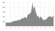
The NASDAQ Composite index from 1994 to 2005 showing the peak of the Dot-com bubble in early 2000, before collapsing.

.jpg)
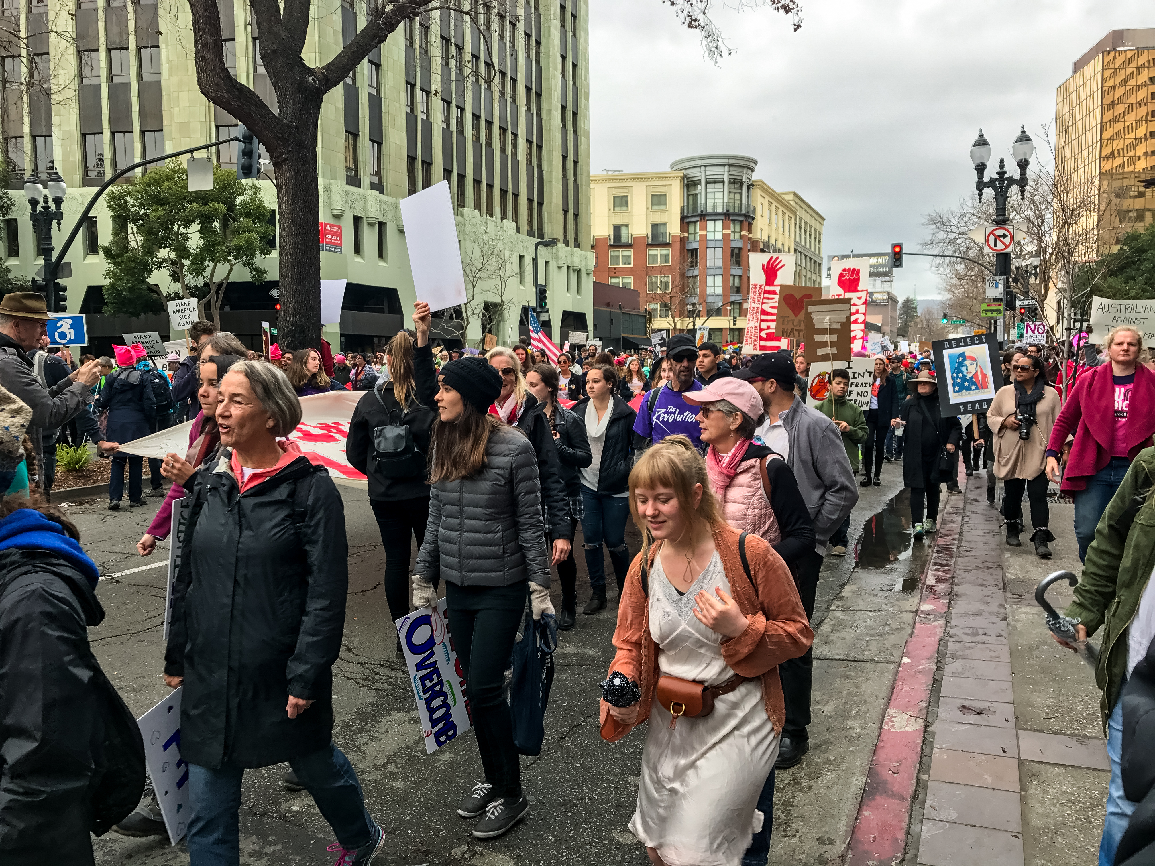
The 2017 Women's March in Oakland. Other political rallies were held on the same day in numerous other locations throughout the Bay Area to spotlight progressive political causes and oppose the Presidency of Donald Trump.
In 1989, in the middle of the World Series match between two Bay Area baseball teams, the Loma Prieta earthquake struck and caused widespread infrastructural damage, including the failure of the Bay Bridge, a major link between San Francisco and Oakland.[50] Even so, the Bay Area's technology industry continued to expand and growth in Silicon Valley accelerated that the United States Census confirmed that year that San Jose had overtaken San Francisco in terms of population.[51] The commercialization of the Internet in the middle of the decade rapidly created a speculative bubble in the high-tech economy known as the Dot-com bubble. This bubble began collapsing in the early 2000s and the industry continued contracting for the next few years, nearly wiping out the market. Companies like Amazon.com and Google managed to weather the crash however, and following the industry's return to normalcy, their market value increased significantly.[52]
Even as the growth of the technology sector transformed the region's economy, progressive politics continued to guide the region's political environment. By the turn of the millennium, Non-Hispanic whites, the largest ethnic group in the United States, were only half of the population in the Bay Area as immigration among minority groups accelerated.[53] During this time, the Bay Area was the center of the LGBT rights movement: in 2004, San Francisco began issuing marriage licenses to same-sex couples, a first in the United States,[54] and four years later, a majority of voters in the Bay Area rejected California Proposition 8, which sought to constitutionally restrict marriage to opposite-sex couples but ultimately passed statewide.[55] The Bay Area was also the center of contentious protests concerning racial and economic inequality. In 2009, an African American man named Oscar Grant was fatally shot by Bay Area Rapid Transit police officers, precipitating widespread protests across the region and even riots in Oakland,[56] and whose name was symbolically tied to the Occupy Oakland protests two years later that sought to fight against social and economic inequality.[57] Following the Inauguration of Donald Trump as President of the United States in 2017, the Bay Area became a center of resistance to his administration, beginning with widespread protests in concert with the nationwide Women's March a day later,[58] followed by frequent public feuds between Trump and various Bay Area political, cultural, and business figures over issues of race and immigration, among others.[59][60]
Culture[]
Arts[]
Art[]


Pixar Animation Studios, whose animated films have accrued numerous Academy Awards, is based in Emeryville.
The Bay Area was a hub of the Abstract Expressionism movement of painting. It is associated with the works of Clyfford Still, who began teaching at the California School of Fine Arts (now the San Francisco Art Institute) in 1946, leaving a lasting impact on the artistic styles of Bay Area painters up to the present day.[61] A few years later, Abstract Expressionist painter David Park painted Kids on Bikes in 1950, which retained many aspects of abstract expressionism but with original distinguishing features that would later lead to the Bay Area Figurative Movement.[62] While both the Figurative Movement and the Abstract Expressionism movement arose from art schools, Funk art would later rise out of the region's underground and was characterized by informal sharing of technique among groups of friends and art showcases in "cooperative" galleries instead of formal museums. Later, the Bay Area art movement would be heavily influenced by the counterculture movement in the 1960s, and art produced during this time reflected the political environment.[63]
The Bay Area is presently home to a thriving computer animation industry[64] led by Pixar Animation Studios and Industrial Light & Magic. Pixar, based in Emeryville, produced the first fully computer animated feature film, Toy Story, with software it designed in-house and whose computer animation films have since garnered 26 Academy Awards and critical acclaim.[65] Industrial Light & Magic, which is based in the Presidio in San Francisco, was created in 1975 to help create visual effects for the Star Wars series has since been involved with creating visual effects for over three hundred Hollywood films.[66]
Music[]
Throughout its recent history, the Bay Area has been home to several musical movements that left lasting influences on the genres they affected. San Francisco, in particular, was the center of the counterculture movement in the 1960s, which directly led to the rise of several notable musical acts: The Grateful Dead, which formed in 1965, and Jefferson Airplane and Janis Joplin; all three would be closely associated with the 1967 Summer of Love.[67] Jimi Hendrix also had strong connections to the movement and the Bay Area, as he lived in Berkeley for a brief time as a child and played in many local venues in that decade.[68][67] By the 1970s, San Francisco had developed a vibrant jazz scene, earning the moniker, "Harlem of the West".[69] The Vietnam War was being fought at the time, and Bay Area bands such as Creedence Clearwater Revival of El Cerrito became known for their political and socially-conscious lyrics against the conflict.[70] Carlos Santana rose to fame in the early 1970s with his Santana band and would later be inducted into the Rock and Roll Hall of Fame,[71] and would later help lead the formation of the band Journey along with former members of Santana.[72]
During the 1980s and early 1990s, the Bay Area became home to one of the largest and most influential thrash metal scenes in the world, with contributions from 3 of the "Big Four" of thrash metal, namely Metallica, Slayer, and Megadeth, and the emergence of the avant-garde metal with bands such as Giant Squid, Grayceon, and Ludicra.[73] The post-grunge era in the 1990s and featured prominent Bay Area bands Third Eye Blind of San Francisco, Counting Crows of Berkeley, and Smash Mouth of San Jose, and later pop punk rock bands like Green Day.[68] The 1990s also saw the emergence of the influential hyphy movement in hip hop, derived from the Oakland slang for "hyperactive", and pioneered by Bay Area rappers Andre "Mac Dre" Hicks, Mistah Fab, and E-40.[74] Other notable rappers from the Bay Area include Lil B,[75] Tupac Shakur, and MC Hammer.[76] Today, much of the rap coming out of the Oakland and the East Bay is "conscious rap", which concerns itself with social issues and awareness.[76]
The Bay Area is also home to hundreds of classical music ensembles, from community choirs to professional orchestras, such as the San Francisco Symphony, California Symphony, Fremont Symphony Orchestra, Oakland Symphony and the San Francisco Chamber Orchestra.[77]
Theater[]

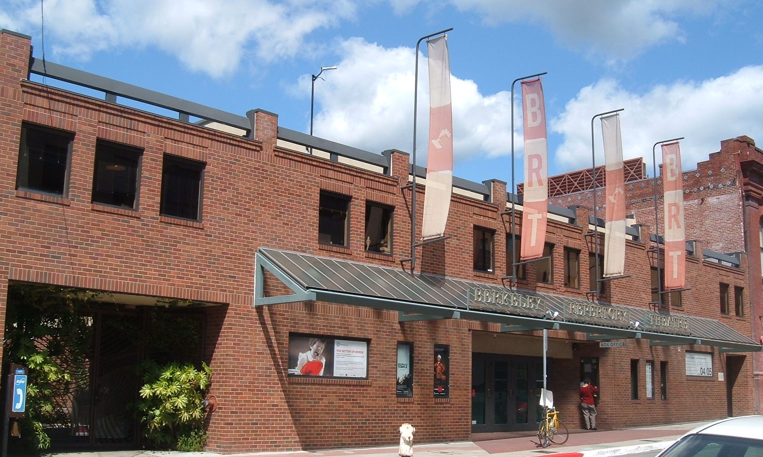
The Berkeley Repertory Theatre is one of the founding members of Theatre Bay Area and are based in a building (pictured above) in downtown Berkeley.
According to the regional theater service organization Theatre Bay Area, the San Francisco Bay Area is the third largest center of activity for theater companies and actors in the United States, after the New York City and Chicago metropolitan areas, with 400 companies spread throughout the region.[78] The organization was founded in 1976 by the Magic Theatre and American Conservatory Theater (ACT) in San Francisco and the Berkeley Repertory Theatre in Berkeley.[79] The latter two, along with the San Francisco Mime Troupe, have since gone on to win one Regional Theatre Tony Award each.[80] Several famous actors have arisen from the Bay Area's theatre community, including Daveed Diggs from Hamilton and Darren Criss from Hedwig, A Very Potter Musical, and Glee.[81] Locally, well-regarded actors include James Carpenter, a stage actor who has performed at the ACT, Berkeley Repertory, and San Jose Repertory Theatre among others, Rod Gnapp of the Magic Theatre Company, Sean San Jose, one of the founders of the Campo Santo theater, and Campo Santo member Margo Hall.[82]
The Bay Area also has an active youth theater scene. ACT and the Berkeley Repertory both run classes and camps for young actors, as do the Peninsula Youth Theater and Willow Glen Children’s Theatre in the Peninsula and South Bay, Bay Area Children's Theater and Danville Children’s Musical Theater in the East Bay, and Marin Shakespeare in the North Bay, among many others.[83][84]
Media[]


The Old Chronicle Building, which housed the offices of the San Francisco Chronicle until 1924.
The San Francisco Bay Area is the sixth-largest television market[85] and the fourth-largest radio market[86] in the U.S. The Bay Area's oldest radio station, KCBS (AM), began as an experimental station in San Jose in 1909, before the beginning of commercial broadcasting.[87] KALW was the Bay Area's first FM radio station, and first radio station to begin commercial broadcasting west of the Mississippi River when it signed on the air in 1941.[88] KPIX, which began broadcasting in 1948, was the first television station to air in the Bay Area and Northern California.[89]
All major U.S. television networks have affiliates serving the region, including KTVU 2 (FOX), KRON-TV 4 (Local News/MyNetwork), KPIX 5 (CBS), KGO-TV 7 (ABC), KQED-TV 9 (PBS), KNTV 11 (NBC), KBCW 44/45 (CW), KQEH 54 (PBS), and KKPX 65 (Ion). Bloomberg West, a show that focuses on topics pertaining to technology and business, was launched in 2011 from a studio in and continues to broadcast from San Francisco.[90]
Public broadcasting outlets include both a television station and a radio station, both broadcasting under the call letters KQED from a facility near the Potrero Hill neighborhood. KQED-FM is the most-listened-to National Public Radio affiliate in the country.[91] Another local broadcaster, KPOO, is an independent, African-American owned and operated noncommercial radio station established in 1971.[92]
The largest newspapers in the Bay Area are the San Francisco Chronicle and San Jose Mercury News, the highest and second-highest most widely circulated newspaper in Northern California.[93] The Chronicle is most famous for a former columnist, the late Herb Caen, whose daily musings attracted critical acclaim and represented the "voice of San Francisco". The San Francisco Examiner, once the cornerstone of William Randolph Hearst's media empire and the home of Ambrose Bierce, declined in circulation over the years and now takes the form of a free daily tabloid, under new ownership.[94][95] Most of the Bay Area's local regions and municipalities also have their own newspapers, such as the East Bay Times and San Mateo Daily Journal. The national newsmagazine Mother Jones is also based in San Francisco.[96] Non-English language newspapers include several Chinese-language papers such as Sing Tao Daily, the largest in the Bay Area by circulation,[97] and El Mundo, a free Spanish-language weekly distributed by the Mercury News.[98]
Sports and recreation[]

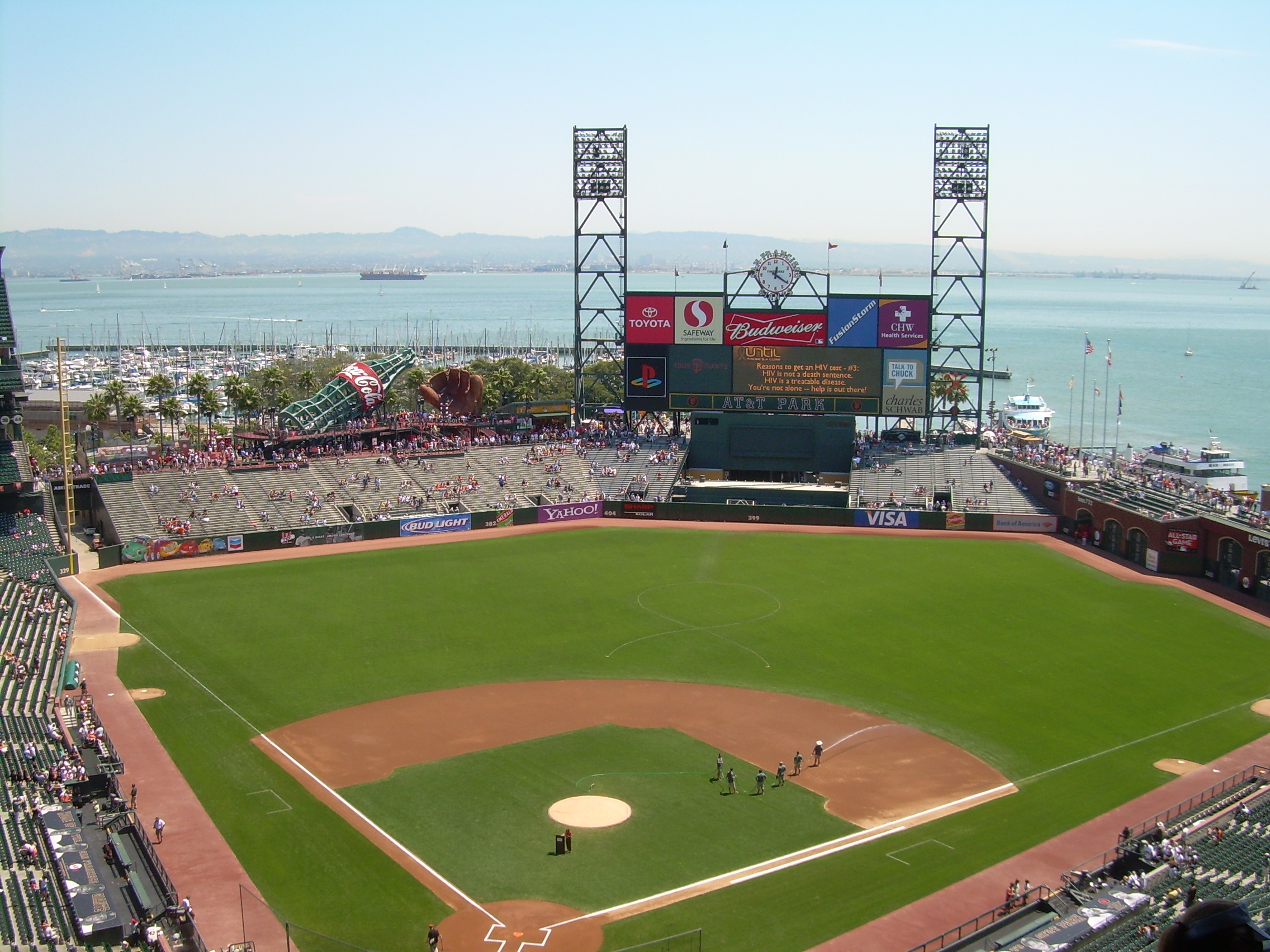
AT&T Park, home to the San Francisco Giants, is situated along the waterfront and has a view of the San Francisco Bay.
A paceline of drafting cyclists while ascending Mount Hamilton in Santa Clara county.
The Bay Area is home to seven professional major league sports franchises: The San Francisco 49ers and Oakland Raiders of the National Football League (NFL) in American football, the San Francisco Giants and Oakland Athletics of Major League Baseball (MLB), the Golden State Warriors of the National Basketball Association (NBA), the San Jose Sharks of the National Hockey League (NHL), and the San Jose Earthquakes of Major League Soccer (MLS).
In football, the 49ers play in Levi's Stadium[99] and have won five Super Bowls (XVI,[100] XIX,[101] XXIII,[102] XXIV,[103] XXIX[104]) and lost one (XLVII[105]), while the Raiders play in Oakland–Alameda County Coliseum[106] until their relocation to Las Vegas in either 2019 or 2020[107] and have won three Super Bowls (XI,[108] XV,[109] XVIII[110]), and lost two (II,[111] XXXVII[112])
In baseball, the Giants, who play at AT&T Park,[113] have won eight World Series titles, three since relocating to San Francisco (2010, 2012, and 2014) from New York in 1958.[114] The A's, who share the Oakland Coliseum with the Raiders,[106] have won nine World Series titles, four since relocating to Oakland (1972, 1973, 1974, and 1989) from Kansas City in 1968.[114]
In basketball, the Warriors play at the Oracle Arena and have won four NBA Finals (1975, 2015, 2017, and 2018) since their move to Oakland in 1971.[115]
In hockey, the Sharks play at the SAP Center and have yet to win the Stanley Cup despite making their first Stanley Cup Finals appearance in 2016.
In soccer, the Earthquakes play at Avaya Stadium[116] and have won the MLS Cup twice in 2001 and 2003.
Outside of major league sports, the Bay Area is home to eight minor league teams. In hockey, the San Jose Barracuda play in the American Hockey League (AHL) and are the top affiliate of the San Jose Sharks, sharing the same rink at the SAP Center in San Jose.[117] In baseball, The San Jose Giants in the California League of Minor League Baseball (MiLB) are the Class-A Advanced affiliate of the San Francisco Giants, playing out of the San Jose Municipal Stadium.[118] There are six teams in the Pacific Association of Professional Baseball Clubs (Martinez Clippers, Napa Silverados, San Rafael Pacifics, Sonoma Stompers, Pittsburg Diamonds, and the Vallejo Admirals).[119]
In terms of collegiate sports, six Bay Area universities are members of NCAA Division I, the highest level of college sports in the country.[120] All three football-playing schools in the Bay Area are in the Football Bowl Subdivision, the highest level of NCAA college football. The California Golden Bears and Stanford Cardinal compete in the Pac-12 Conference, and the San Jose State Spartans compete in the Mountain West Conference.[121] The Cardinal and Golden Bears are intense rivals, with their football teams competing annually in the Big Game for the Stanford Axe.[122] One of the most famous games in the rivalry occurred in 1982, when the Golden Bears defeated the Cardinal on a last-second return kickoff known as "The Play".[123]
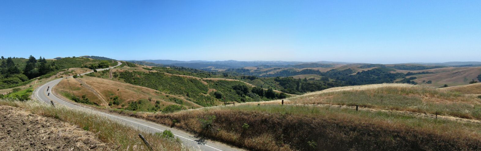
The Bay Area has an ideal climate for outdoor recreation, such that activities like hiking and cycling are popular among locals.[124][125] There are more than 200 miles (320 km) of bicycle paths, lanes and bike routes just within San Francisco,[126] and the Embarcadero and Marina Green are favored sites for skateboarding. Extensive public tennis facilities are available in Golden Gate Park and Dolores Park, as well as at smaller neighborhood courts throughout the city. San Francisco residents have often ranked among the fittest in the U.S.[127] Boating, sailing, windsurfing and kitesurfing are among the popular activities on San Francisco Bay, and the city maintains a yacht harbor in the Marina District. The St. Francis Yacht Club and Golden Gate Yacht Club are located in the Marina Harbor,[128][129] while the South Beach Yacht Club is located next to AT&T Park.[130] The Bay Area was host to the 2013 America's Cup.
Demographics[]


San Jose is home to the largest Vietnamese community outside of Vietnam. Here, the Vietnamese diaspora celebrate Tết, or New Years, in San Jose.
| Historical populations | |||
|---|---|---|---|
| Census | Pop. | %± | |
| 1860 | 114,074 | ||
| 1870 | 265,808 | 133.0% | |
| 1880 | 422,128 | 58.8% | |
| 1890 | 547,618 | 29.7% | |
| 1900 | 658,111 | 20.2% | |
| 1910 | 925,708 | 40.7% | |
| 1920 | 1,182,911 | 27.8% | |
| 1930 | 1,578,009 | 33.4% | |
| 1940 | 1,734,308 | 9.9% | |
| 1950 | 2,681,322 | 54.6% | |
| 1960 | 3,638,939 | 35.7% | |
| 1970 | 4,628,199 | 27.2% | |
| 1980 | 5,179,784 | 11.9% | |
| 1990 | 6,023,577 | 16.3% | |
| 2000 | 6,783,760 | 12.6% | |
| 2010 | 7,150,739 | 5.4% | |
| Est. 2017 | 7,756,158 | [131] | 14.3% |
| Note: Nine-County Population Totals[53] | |||
Maps of racial distribution according to 2010 U.S. Census. Each dot is 25 people: White, African, Asian, Hispanic, or Other (yellow)


According to the 2010 United States Census, the population of the nine-county Bay Area was 7.15 million, with 49.6% male and 50.4% female.[53] Of these, approximately 2.3 million (32%) are foreign born.[132] In 2010 the racial makeup of the nine-county Bay Area was 52.5% White of which 42.4% were non-Hispanic and 10.1% were Hispanic, 23.5% Hispanic or Latino of any race (17.9% Mexican, 1.3% Salvadoran, 0.6% Guatemalan, 0.6% Puerto Rican, 0.5% Nicaraguan, 0.3% Peruvian, 0.2% Cuban), 23.3% Asian (7.9% Chinese, 5.1% Filipino, 3.3% Indian, 2.5% Vietnamese, 1.0% Korean, 0.9% Japanese, 0.2% Pakistani, 0.2% Cambodian, 0.2% Laotian, 0.1% Thai, 0.1% Burmese), 6.7% non-Hispanic African American, 0.7% Native American or Alaska Native, 0.6% Pacific Islander (0.1% Tongan, 0.1% Samoan, 0.1% Fijian, >0.1% Guamanian, >0.1% Native Hawaiian), 5.4% from two or more races and 10.8% from other races.[133] The Bay Area cities of Vallejo, Suisun City, Oakland, San Leandro, Fairfield, and Richmond are among the most ethnically diverse cities in the United States.[134]
Based on geographic location, non-Hispanic whites make up the majority in Marin, Napa, and Sonoma counties.[53] Whites also make up the majority in the eastern regions of the East Bay centered around Livermore and Walnut Creek areas.[53] San Francisco's North Beach district is considered the Little Italy of the city, and was once home to a significant Italian American community. San Francisco and Marin County both have substantial Jewish communities.[135] The Latino population is spread throughout the Bay Area, but among the nine counties, the greatest number of them live in Santa Clara County, while Contra Costa County sees the highest growth rate.[136] Mexican Americans make up the largest share of Hispanic residents in Napa county,[137] while Central Americans make up the largest share in San Francisco, many of whom live in the Mission District which is home to many residents of Salvadoran and Guatemalan descent.[138]
The Asian American population in the Bay Area is significant compared to other regions in the U.S., concentrated in the Bay Area city of Daly City. At 58.4%, Daly City's Asian American population is larger than anywhere else in the United States outside of Hawaii.[139] Asian Americans also constitute a majority in Fremont, with significant populations in Sunnyvale and Santa Clara. The cities of San Jose and San Francisco had the third and fourth largest total number of Asian Americans out of every American city.[140] In San Francisco, Chinese Americans constitute 21.4% of the population and constitute the single largest ethnic group in the city.[141] The Bay Area is home to over 382,950 Filipino Americans, one of the largest communities of Filipino people outside of the Philippines with the largest proportion of Filipino Americans concentrating themselves within American Canyon, Daly City, Fairfield, South San Francisco and Vallejo.[142] Santa Clara county, and increasingly the East Bay, house a significant Indian American community.[143] There are more than 100,000 people of Vietnamese ancestry residing within San Jose city limits, the largest Vietnamese population of any city in the world outside of Vietnam.[144] In addition, there is a sizable community of Korean Americans in Santa Clara county, where San Jose is located.[145] East Bay cities such as Richmond and Oakland, and the North Bay city of Santa Rosa, have plentiful populations of Laotian and Cambodians in certain neighborhoods.[146] Pacific Islanders such as Samoans and Tongans have the largest presence in East Palo Alto, where they constitute over 7% of the population.[147]
The African American population of the Bay Area used to be significant in San Francisco, where one out of seven residents were black in 1970, which had a thriving jazz scene and was known as "Harlem of the West". Today, they have mostly moved to parts of the East Bay and North Bay, including the cities of Oakland and Antioch.[69] The South Park neighborhood of Santa Rosa was home to once a primarily black community until the 1980s, when many Latino immigrants settled in the area.[148] Other cities with large numbers of African Americans include Vallejo (28%),[149] Richmond (26%),[150] and East Palo Alto (17%).[147]
Since the economy of the Bay Area heavily relies on innovation and high-tech skills, a greater, educated population exists in the region. Roughly 87.4% of Bay Area residents have attained a high school degree or higher,[151] while 46% of adults in the Bay Area have earned a post-secondary degree or higher.[152]
The Bay Area is one of the wealthiest regions in the United States, due, primarily, to the economic power engines of San Jose, San Francisco, and Oakland. The Bay Area city of Pleasanton has the second-highest household income in the country after New Canaan, Connecticut. However, discretionary income is very comparable with the rest of the country, primarily because the higher cost of living offsets the increased income.[153]
By 2014, the Bay Area's wealth gap was considerable: the top ten percent of income-earners took home over eleven times as much as the bottom ten percent,[154] and a Brookings Institution study found the San Francisco metro area, which excludes four Bay Area counties, to be the third most unequal urban area in the country.[155] Among the wealthy, there are forty-seven Bay Area residents made the Forbes magazine's 400 richest Americans list, published in 2007. Thirteen lived in San Francisco proper, placing it seventh among cities in the world. Among the forty-seven were several well-known names such as Steve Jobs, George Lucas, and Charles Schwab. The wealthiest resident was Larry Ellison of Oracle, worth $25 billion.[156] A study by Capgemini indicates that in 2009, 4.5 percent of all households within the San Francisco-Oakland and San Jose metropolitan areas held $1 million in investable assets, placing the region first in the United States, just ahead of the New York City metro region.[157] On the other hand, low income residents in the Bay Area saw their incomes fall by nine percent since 2007, with the bottom ten percent earning just $20,000 on average.[154]
| Counties by population and ethnicity | ||||||||
|---|---|---|---|---|---|---|---|---|
| County | Type | Population | White | Other | Asian | African | Native | Hispanic |
| Alameda | County | 1,494,876 | 46.2% | 13.8% | 26.2% | 12.5% | 1.3% | 22.2% |
| Contra Costa | County | 1,037,817 | 63.2% | 12.5% | 14.3% | 9.1% | 0.5% | 23.9% |
| Marin | County | 250,666 | 79.9% | 11.0% | 5.6% | 3.0% | 0.2% | 14.0% |
| Napa | County | 135,377 | 81.3% | 8.9% | 6.8% | 2.0% | 0.3% | 31.5% |
| San Francisco | City and county | 870,887 | 48.5% | 11.3% | 33.3% | 6.1% | 0.9% | 15.1% |
| San Mateo | County | 711,622 | 59.6% | 11.1% | 24.6% | 2.9% | 1.8% | 24.9% |
| Santa Clara | County | 1,762,754 | 50.9% | 13.8% | 31.8% | 2.6% | 0.4% | 26.6% |
| Solano | County | 411,620 | 52.1% | 17.6% | 14.4% | 14.6% | 1.4% | 23.6% |
| Sonoma | County | 478,551 | 81.6% | 11.3% | 4.0% | 1.2% | 1.5% | 24.3% |
| Counties by population and income | |||||
|---|---|---|---|---|---|
| County | Type | Population | Per capita income | Median household income | Median family income |
| Alameda | County | 1,494,876 | $34,937 | $70,821 | $87,012 |
| Contra Costa | County | 1,037,817 | $38,141 | $79,135 | $93,437 |
| Marin | County | 250,666 | $54,605 | $89,605 | $113,826 |
| Napa | County | 135,377 | $35,309 | $68,641 | $79,884 |
| San Francisco | City and county | 870,887 | $46,777 | $72,947 | $87,329 |
| San Mateo | County | 711,622 | $45,346 | $87,633 | $104,370 |
| Santa Clara | County | 1,762,754 | $40,698 | $89,064 | $103,255 |
| Solano | County | 411,620 | $29,367 | $69,914 | $79,316 |
| Sonoma | County | 478,551 | $33,119 | $64,343 | $78,227 |
Crime[]
Statistics regarding crime rates in the Bay Area generally fall into two categories: violent crime and property crime. Historically, violent crime has been concentrated in a few cities in the East Bay, namely Oakland, Richmond, and Antioch, but also East Palo Alto in the Peninsula, Vallejo in the North Bay, and San Francisco.[158] Nationally, Oakland's murder rate ranked 18th among cities with over 100,000 residents, and third for violent crimes per capita.[159] According to a 2015 Federal Bureau of Investigation report, Oakland was also the source of the most violent crime in the Bay Area, with 16.9 reported incidents per thousand people. Vallejo came in second, at 8.7 incidents per thousand people, while San Pablo, Antioch, and San Francisco rounded out the top five. East Palo Alto, which used to have the Bay Area's highest murder rate, saw violent crime incidents drop 65% between 2013 and 2014, while Oakland saw violent crime incidents drop 15%.[158] Meanwhile, San Jose, which was one of the safest large cities in the United States in the early 2000s, has seen its violent crime rates trend upwards.[160] Cities with the lowest rate of violent crime include the Peninsula cities of Los Altos and Foster City, East Bay cities of San Ramon and Danville, and South Bay cities of Saratoga and Cupertino. In 2015, 45 Bay Area cities counted zero homicides, the largest of which was Daly City.[158]
In 2015, Oakland also saw the highest rates of property crime in the Bay Area, at 59.4 incidents per thousand residents, with San Francisco following close behind at 53 incidents per thousand residents. The East Bay cities Pleasant Hill, Berkeley, and San Leandro rounded out the top five. The South Bay city of Saratoga and the North Bay city of Windsor saw the least rates of property crime.[158] Additionally, San Francisco saw the most reports of arson.[159]
Several street gangs operate in the Bay Area, including the Sureños and Norteños in San Francisco's Mission District.[161] African-American street gangs familiar in other cities, including the Crips, have struggled to establish footholds in the city,[162] although gangs with shotcallers in China, including Triad groups such as the Wo Hop To, have been reported active.[163] In 1977, an ongoing rivalry between two Chinese gangs led to a shooting attack at the Golden Dragon restaurant in Chinatown, which left five people dead and eleven wounded. Five members of the Joe Boys gang were arrested and convicted of the crime.[164] Oakland, which also sees organized gang violence, implemented Operation Ceasefire in 2012 in an effort to reduce the violence.[165]
Economy[]


.jpg)
Google, a multinational technology company and subsidiary of Alphabet Inc., is headquartered in the Bay Area city of Mountain View.
The three principal cities of the Bay Area represent different employment clusters and are dominated by different, but commingled, industries. San Francisco is home to the region's financial and business industry, tourism, and is host to numerous conventions. The East Bay, centered around Oakland, is home to heavy industry, metalworking, oil, and shipping, while Silicon Valley is a major pole of economic activity around the technology industry. Furthermore, the North Bay is a major player in the country's agriculture and wine industry.[8] In all, the Bay Area is home to the second highest concentration of Fortune 500 companies, second only to the New York metropolitan area, with thirty such companies based throughout the region.[166] In 2016, the greater twelve-county statistical area had a GDP of $820.9 billion, the third-highest among combined statistical areas.[167] The smaller nine-county Bay Area had a GDP of $781 billion, which nonetheless would rank it 5th among U.S. states and 18th among countries.[168]
Several major corporations are headquartered in the Bay Area. Among the Fortune 500 companies located in the region include technology companies Google, Apple Inc., Hewlett Packard, Intel, Applied Materials, eBay, Cisco Systems, Symantec, Oracle, Netflix, and Salesforce; energy companies Chevron and PG&E; financial service companies Charles Schwab Corporation, Visa Inc., and Wells Fargo; apparel retailers Gap Inc., Levi Strauss & Co., and Ross Stores; aerospace and defense contractor Lockheed Martin; local grocer Safeway; pharmaceutical company McKesson; and biotechnology companies Genentech and Gilead Sciences.[169] The largest manufacturers include Tesla Inc., Lam Research, Bayer, Chevron, and Coca-Cola.[170] Oakland is the site of the fifth-largest container shipping port in the United States and is also a major rail terminus.[171] In research, NASA's Ames Research Center and the federal research facility Lawrence Livermore National Laboratory are based in Mountain View and Livermore respectively. In the North Bay, Napa and Sonoma counties are known for their famous wineries, including Fantesca Estate & Winery, Domaine Chandon California, and D'Agostini Winery.[172]
Housing[]
The Bay Area is one of the most expensive places to live in the United States. Strong economic growth has created hundreds of thousands of new jobs, but coupled with severe restrictions on building new housing units,[173] has resulted in an extreme housing shortage. For example, from 2012 to 2017, the San Francisco metropolitan area added 400,000 new jobs, but only 60,000 new housing units.[174] As of 2016, the entire Bay Area had 3.6 M jobs, and 2.6 M housing units, for a ratio of 1.4 jobs per housing unit,[175] significantly above the ratio for the US as a whole, which stands at 1.1 jobs per housing unit. (152M jobs, 136M housing units[176][177]) According to a survey conducted by the United States Census Bureau, the Bay Area ranks #1 "in median home value, median monthly costs for homes with a mortgage, and median gross rent." [178][179] As of 2017, the average income needed in order to purchase a house in the region was $179,390, while the median price for a house was $895,000 and the average cost of a home in the Bay Area being $440,000 - more than twice the national average, while the average monthly rent is $1,240 - 50 percent more than the national average.[180][181]
With high costs of living, many Bay Area residents allocate large amounts of their income towards housing. 20 percent of Bay Area homeowners spend more than half their income on housing, while roughly 25 percent of renters in the Bay Area spend more than half of their incomes in the Bay Area.[182] Expending an average of more than $28,000 per year on housing in addition to roughly $13,400 on transportation, Bay Area residents spend around $41,420 per year to live in the region. This combined total of housing and transportation signifies 59 percent of the Bay Area's median household income, conveying the extreme costs of living.[182] The high rate of homelessness in the Bay Area can be attributed to the high cost of living.[183] No approximate number of homeless people living in the Bay Area can be determined due to the difficulty of tracking homeless residents.[183] However, according to San Francisco’s Department of Public Health, the number of homeless people in San Francisco alone is 9,975.[184] Additionally, San Francisco was revealed to have the most unsheltered homeless people in the country.[184]
Because of the high cost of housing, many workers in the Bay Area live far from their place of employment, contributing to one of the highest percentages of extreme commuters in the United States, or commutes that take over ninety minutes in one direction. For example, about 50,000 people commute from neighboring San Joaquin county into the nine-county Bay Area daily,[185] and more extremely, some workers commute daily by flying.[186]
Education[]
Colleges and universities[]


The Memorial Glade of Sather Tower in the University of California, Berkeley campus. Berkeley is the highest-ranked public university in the United States, according to US News & World Report.
The Bay Area is home to a large number of colleges and universities. The first institution of higher education in the Bay Area, Santa Clara University, was founded by Jesuits in 1851,[187] who also founded the University of San Francisco in 1855.[188] San Jose State University was founded in 1857 and is the oldest public college on the West Coast of the United States.[189] According to the Brookings Institution, 45% of residents of the two-county San Jose metro area have a college degree and 43% of residents in the five-county San Francisco metro area have a college degree, the second and fourth highest ranked metro areas in the country for higher educational attainment.[190]
Rankings compiled by U.S. News & World Report feature several Bay Area universities in prominent spots. Stanford University is the highest ranked university in the Bay Area, and fifth overall in the United States. The University of California, Berkeley is ranked twentieth overall, but for the past nineteen years has been highest-ranked public university in the country. Additionally, San Jose State University and Sonoma State University were respectively ranked sixth and tenth among public colleges in the West Coast.[191]
The city of San Francisco is host to two additional University of California schools, neither of which confer undergraduate degrees. The University of California, San Francisco is entirely dedicated to graduate education in health and biomedical sciences. It is ranked among the top five medical schools in the United States[192] and operates the UCSF Medical Center, which is the highest-ranked hospital in California.[193] The University of California, Hastings College of the Law, founded in Civic Center in 1878, is the oldest law school in California and claims more judges on the state bench than any other institution.[194] The city is also host to a California State University school, San Francisco State University.[195]
California Community Colleges System also operates a number of community colleges in the Bay Area. According to CNNMoney, the Bay Area community college with the highest "success" rate is De Anza College in Cupertino, which is also the tenth-highest ranked in the nation. Other relatively well-ranked Bay Area community colleges include Foothill College, City College of San Francisco, West Valley College, Diablo Valley College, and Las Positas College.[196]
Many scholars have pointed out the overlap of education and the economy within the Bay Area. According to multiple reports, research universities such as Stanford University, University of California - Santa Cruz and University of California - Berkeley, are essential to the culture and economy in the area.[152] These universities also provide countless, public programs for people to learn and enhance skills relevant to the local economies. These opportunities not only provide educational services to the community, but also generates significant amounts of revenue.[152]
Primary and secondary schools[]
Public primary and secondary education in the Bay Area is provided through school districts organized through three structures: elementary school districts, high school districts, or unified school districts, and are governed by an elected board. In addition, many Bay Area counties and the city of San Francisco operate "special service schools" that are geared towards providing education to students with handicaps or special needs.[197] An alternative public educational setting is offered by charter schools, which may be established with a renewable charter of up to five years by third parties. The mechanism for charter schools in the Bay Area is governed by the California Charter Schools Act of 1992.[198]
According to rankings compiled by U.S. News & World Report, the highest-ranked high school in California is the Pacific Collegiate School, located in Santa Cruz and part of the greater Bay Area. Within the traditional nine-county boundaries, the highest ranked high school is KIPP San Jose Collegiate in San Jose. Among the top twenty high schools in California include Lowell High School in San Francisco, Monta Vista High School in Cupertino, the University Preparatory Academy in San Jose, Mission San Jose High School in Fremont, Oakland Charter High School in Oakland, Henry M. Gunn High School in Palo Alto, and Saratoga High School in Saratoga.[199]
Geography[]
Climate[]

The Bay Area is located in the relatively rare warm-summer Mediterranean climate zone (Köppen Csb) that is a characteristic of California's coast, with moist mild winters and dry summers.[200] It is largely influenced by the cold California Current, which penetrates the natural mountainous barrier along the coast by traveling through various gaps.[201] In terms of precipitation, this means that the Bay Area has pronounced wet and dry seasons. The wet season, which roughly runs between November and March, is the source of about 82% of annual precipitation in the area. In the South Bay and further inland, while the wet season is cool and mild, the summer dry season is characterized by warm sunny days,[201] while in San Francisco and areas closer to the Golden Gate strait, the dry season is periodically affected by fog.[202]
Due to the Bay Area's diverse topography, the result of the clashing tectonic plates, the region is home to numerous microclimates that lead to pronounced differences in climate and temperature over short distances.[200][203] Within the city of San Francisco, natural and artificial topographical features direct the movement of wind and fog, resulting in startlingly varied climates between city blocks. Along the Golden Gate Strait, oceanic wind and fog from the Pacific Ocean are able to penetrate the mountain barriers inland into the Bay Area.[203] During the summer, rising hot air in California's interior valleys creates a low pressure area that draws winds from the North Pacific High through the Golden Gate, which creates the city's characteristic cool winds and fog.[202] The microclimate phenomenon is most pronounced during this time, when fog penetration is at its maximum in areas near the Golden Gate strait,[203] while the South Bay and areas further inland are sunny and dry.[201]
Along the San Francisco peninsula, gaps in the Santa Cruz Mountains, one south of San Bruno Mountain and another in Crystal Springs, allow oceanic weather into the interior and causing a cooling effect for cities along the Peninsula and even as far south as San Jose. This weather pattern is also the source for delays at San Francisco International Airport. In Marin county north of the Golden Gate strait, two gaps north of Muir Woods bring cold air across the Marin Headlands, with the cooling affect reaching as far north as Santa Rosa.[203] Further inland, the East Bay receives oceanic weather that travels through the Golden Gate strait, and further diffuses that air through the Berkeley Hills, Niles Canyon and the Hayward Pass into the Livermore Valley and Altamont Pass. Here, the resulting breeze is so strong that it is home to one of the world's largest array of wind turbines. Further north, the Carquinez Strait funnels the ocean weather into the San Joaquin River Delta, causing a cooling effect in Stockton and Sacramento, so that these cities are also cooler than their Central Valley counterparts in the south.[203]
| City | Template:Tooltip | Template:Tooltip | Template:Tooltip | Template:Tooltip | May | Template:Tooltip | Template:Tooltip | Template:Tooltip | Template:Tooltip | Template:Tooltip | Template:Tooltip | Template:Tooltip |
|---|---|---|---|---|---|---|---|---|---|---|---|---|
| Fairfield[204] | data-sort-value="46.9" title="average temperature: 46.9" Template:Average temperature table/color | Template:Convert// | data-sort-value="51.5" title="average temperature: 51.5" Template:Average temperature table/color | Template:Convert// | data-sort-value="55.4" title="average temperature: 55.4" Template:Average temperature table/color | Template:Convert// | data-sort-value="59.1" title="average temperature: 59.1" Template:Average temperature table/color | Template:Convert// | data-sort-value="64.9" title="average temperature: 64.9" Template:Average temperature table/color | Template:Convert// | data-sort-value="70.3" title="average temperature: 70.3" Template:Average temperature table/color | Template:Convert// | data-sort-value="73.6" title="average temperature: 73.6" Template:Average temperature table/color | Template:Convert// | data-sort-value="73.1" title="average temperature: 73.1" Template:Average temperature table/color | Template:Convert// | data-sort-value="71.0" title="average temperature: 71.0" Template:Average temperature table/color | Template:Convert// | data-sort-value="64.3" title="average temperature: 64.3" Template:Average temperature table/color | Template:Convert// | data-sort-value="54.6" title="average temperature: 54.6" Template:Average temperature table/color | Template:Convert// | data-sort-value="47.1" title="average temperature: 47.1" Template:Average temperature table/color | Template:Convert// |
| Oakland[205] | data-sort-value="58.1" title="average temperature: 51.2" Template:Average temperature table/color | Template:Convert// | data-sort-value="54.2" title="average temperature: 54.2" Template:Average temperature table/color | Template:Convert// | data-sort-value="56.2" title="average temperature: 56.2" Template:Average temperature table/color | Template:Convert// | data-sort-value="58.2" title="average temperature: 58.2" Template:Average temperature table/color | Template:Convert// | data-sort-value="60.7" title="average temperature: 60.7" Template:Average temperature table/color | Template:Convert// | data-sort-value="63.2" title="average temperature: 63.2" Template:Average temperature table/color | Template:Convert// | data-sort-value="64.1" title="average temperature: 64.1" Template:Average temperature table/color | Template:Convert// | data-sort-value="65.3" title="average temperature: 65.3" Template:Average temperature table/color | Template:Convert// | data-sort-value="65.6" title="average temperature: 65.6" Template:Average temperature table/color | Template:Convert// | data-sort-value="63.0" title="average temperature: 63.0" Template:Average temperature table/color | Template:Convert// | data-sort-value="56.9" title="average temperature: 56.9" Template:Average temperature table/color | Template:Convert// | data-sort-value="51.5" title="average temperature: 51.5" Template:Average temperature table/color | Template:Convert// |
| San Francisco[206] | data-sort-value="51.3" title="average temperature: 51.3" Template:Average temperature table/color | Template:Convert// | data-sort-value="53.9" title="average temperature: 53.9" Template:Average temperature table/color | Template:Convert// | data-sort-value="55.1" title="average temperature: 55.1" Template:Average temperature table/color | Template:Convert// | data-sort-value="56.2" title="average temperature: 56.2" Template:Average temperature table/color | Template:Convert// | data-sort-value="57.6" title="average temperature: 57.6" Template:Average temperature table/color | Template:Convert// | data-sort-value="59.6" title="average temperature: 59.6" Template:Average temperature table/color | Template:Convert// | data-sort-value="60.3" title="average temperature: 60.3" Template:Average temperature table/color | Template:Convert// | data-sort-value="61.6" title="average temperature: 61.6" Template:Average temperature table/color | Template:Convert// | data-sort-value="62.7" title="average temperature: 62.7" Template:Average temperature table/color | Template:Convert// | data-sort-value="61.5" title="average temperature: 61.5" Template:Average temperature table/color | Template:Convert// | data-sort-value="56.6" title="average temperature: 56.6" Template:Average temperature table/color | Template:Convert// | data-sort-value="51.6" title="average temperature: 51.6" Template:Average temperature table/color | Template:Convert// |
| San Jose[207] | data-sort-value="50.1" title="average temperature: 50.1" Template:Average temperature table/color | Template:Convert// | data-sort-value="53.3" title="average temperature: 53.3" Template:Average temperature table/color | Template:Convert// | data-sort-value="56.2" title="average temperature: 56.2" Template:Average temperature table/color | Template:Convert// | data-sort-value="58.9" title="average temperature: 58.9" Template:Average temperature table/color | Template:Convert// | data-sort-value="63.4" title="average temperature: 63.4" Template:Average temperature table/color | Template:Convert// | data-sort-value="67.5" title="average temperature: 67.5" Template:Average temperature table/color | Template:Convert// | data-sort-value="70.0" title="average temperature: 70.0" Template:Average temperature table/color | Template:Convert// | data-sort-value="70.1" title="average temperature: 70.1" Template:Average temperature table/color | Template:Convert// | data-sort-value="68.5" title="average temperature: 68.5" Template:Average temperature table/color | Template:Convert// | data-sort-value="63.2" title="average temperature: 63.2" Template:Average temperature table/color | Template:Convert// | data-sort-value="55.1" title="average temperature: 55.1" Template:Average temperature table/color | Template:Convert// | data-sort-value="50.0" title="average temperature: 50.0" Template:Average temperature table/color | Template:Convert// |
| Santa Rosa[208] | data-sort-value="49.1" title="average temperature: 49.1" Template:Average temperature table/color | Template:Convert// | data-sort-value="52.2" title="average temperature: 52.2" Template:Average temperature table/color | Template:Convert// | data-sort-value="54.8" title="average temperature: 54.8" Template:Average temperature table/color | Template:Convert// | data-sort-value="57.6" title="average temperature: 57.6" Template:Average temperature table/color | Template:Convert// | data-sort-value="61.4" title="average temperature: 61.4" Template:Average temperature table/color | Template:Convert// | data-sort-value="65.9" title="average temperature: 65.9" Template:Average temperature table/color | Template:Convert// | data-sort-value="67.3" title="average temperature: 67.3" Template:Average temperature table/color | Template:Convert// | data-sort-value="67.7" title="average temperature: 67.7" Template:Average temperature table/color | Template:Convert// | data-sort-value="67.4" title="average temperature: 67.4" Template:Average temperature table/color | Template:Convert// | data-sort-value="63.1" title="average temperature: 63.1" Template:Average temperature table/color | Template:Convert// | data-sort-value="54.8" title="average temperature: 54.8" Template:Average temperature table/color | Template:Convert// | data-sort-value="49.0" title="average temperature: 49.0" Template:Average temperature table/color | Template:Convert// |
Ecology[]
Marine wildlife[]
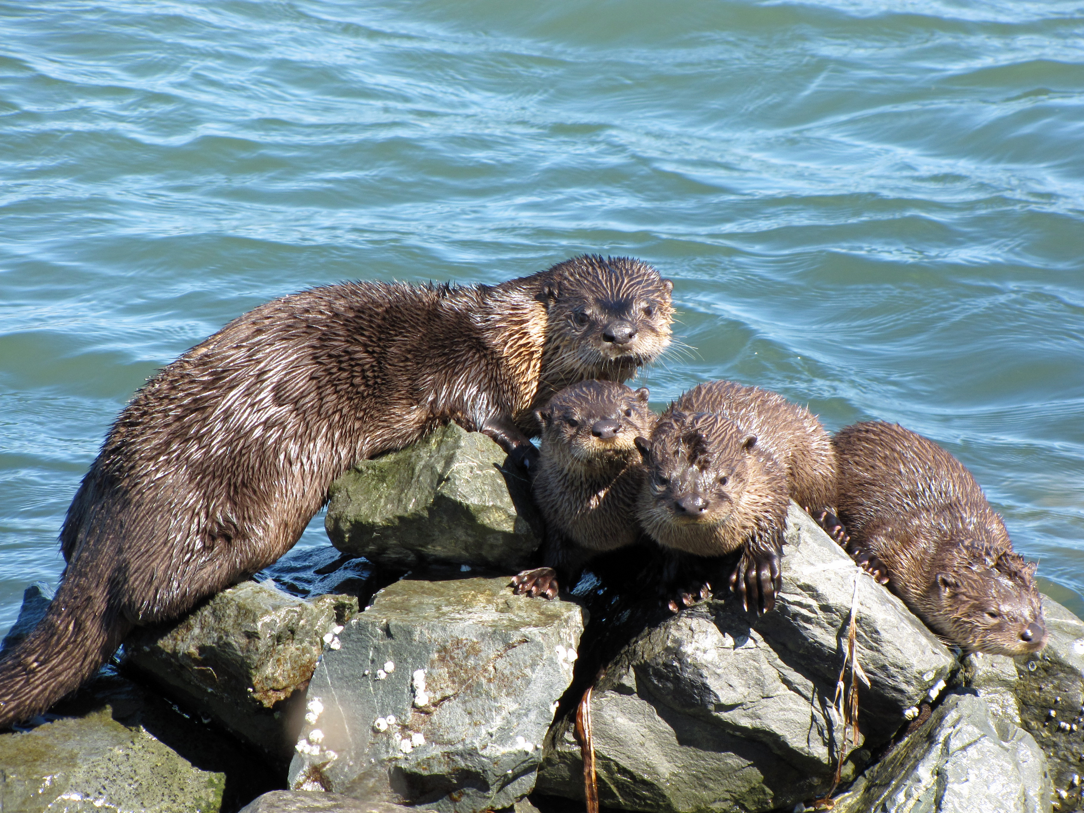

River otter sunning on rocks in the Richmond Marina.


A California golden beaver in Alhambra Creek in Martinez.
The Bay Area is home to a diverse array of wildlife and, along with the connected San Joaquin River Delta represents one of California's most important ecological habitats.[209] California's Dungeness crab, Pacific halibut, and the California scorpionfish are all significant components of the bay's fisheries.[210] The bay's salt marshes now represent most of California's remaining salt marsh and support a number of endangered species and provide key ecosystem services such as filtering pollutants and sediments from the rivers.[211] Most famously, the bay is a key link in the Pacific Flyway and with millions of shorebirds annually visiting the bay shallows as a refuge, is the most important component of the flyway south of Alaska.[212] Many endangered species of birds are also found here: the California least tern, the California clapper rail, the snowy egret, and the black crowned night heron.[213]
There is also a significant diversity of salmonids present in the bay. Steelhead populations in California have dramatically declined due to human and natural causes; in the Bay Area, all naturally spawned anadromous steelhead populations below natural and manmade impassable barriers in California streams from the Russian River to Aptos Creek, and the drainages of San Francisco, San Pablo, and Suisun Bays are listed as threatened under the Federal Endangered Species Act.[214] The Central California Coast coho salmon population is the most endangered of the many troubled salmon populations on the west coast of the United States, including populations residing in tributaries to the San Francisco Bay.[215] Industrial, mining, and other uses of mercury have resulted in a widespread distribution of that poisonous metal in the bay, with uptake in the bay's phytoplankton and contamination of its sportfish.[216]
Aquatic mammals are also present in the bay. Before 1825, Spanish, French, English, Russians and Americans were drawn to the Bay Area to harvest prodigious quantities of beaver, river otter, marten, fisher, mink, fox, weasel, harbor and fur seals and sea otter. This early fur trade, known as the California Fur Rush, was more than any other single factor, responsible for opening up the West and the San Francisco Bay Area, in particular, to world trade.[217] By 1817 sea otter in the area were practically eliminated.[218] Since then, the California golden beaver has re-established a presence in the Alhambra Creek.[219] The North American river otter which was first reported in Redwood Creek at Muir Beach in 1996,[220] has since been spotted in the North Bay's Corte Madera Creek, the South Bay's Coyote Creek,[221] as well as in 2010 in San Francisco Bay itself at the Richmond Marina. Other mammals include the internationally famous sea lions who began inhabiting San Francisco's Pier 39 after the 1989 Loma Prieta earthquake[222] and the locally famous Humphrey the Whale, a humpback whale who entered San Francisco Bay twice on errant migrations in the late 1980s and early 1990s.[223] Bottlenose dolphins and harbor porpoises have recently returned to the bay, having been absent for many decades. Historically, this was the northern extent of their warm-water species range.[224]
Birds[]


A family of owls turned out of their homes in Antioch.
In addition to the many species of marine birds that can be seen in the Bay Area, many other species of birds make the Bay Area their home, making the region a popular destination for birdwatching.[225] Many birds, including many described in the following paragraphs, are listed as endangered species despite once being common in the region, due to human and other impacts.
Western burrowing owls were originally listed as a species of special concern by the California Department of Fish and Game in 1979. California's population declined 60% from the 1980s to the early 1990s, and continues to decline at roughly 8% per year.[226] A 1992–93 survey reported little to no breeding burrowing owls in most of the western counties in the Bay Area, leaving only Alameda, Contra Costa, and Solano counties as remnants of a once large breeding range.[227] Bald eagles were once common in the Bay Area, but habitat destruction and thinning of eggs from DDT poisoning reduced the California state population to 35 nesting pairs. Bald eagles disappeared from the Bay Area in 1915, and only began returning in recent years.[228] In the 1980s an effort to re-introduce the species to the area began with the Santa Cruz Predatory Bird Research Group and the San Francisco Zoo importing birds and eggs from Vancouver Island and northeastern California,[229] and there are now nineteen nesting couples in eight of the Bay Area's nine counties.[228] Other once absent species that have returned to the Bay Area include Swainson’s hawk, white tailed kite, and the osprey.[228]
In 1927, zoologist Joseph Grinnell wrote that osprey were only rare visitors to the San Francisco Bay Area, although he noted records of one or two used nests in the broken tops of redwood trees along the Russian River.[230] In 1989, the southern breeding range of the osprey in the Bay Area was Kent Lake, although osprey were noted to be extending their range further south in the Central Valley and the Sierra Nevada.[231] In 2014, a Bay Area-wide survey found osprey had extended their breeding range southward with nesting sites as far south as Hunters Point in San Francisco on the west side and Hayward on the east side, while further studies have found nesting sites as far south as the Los Gatos Creek watershed, indicating that the nesting range now includes the entire length of San Francisco Bay.[232] Most nests were built on man-made structures close to areas of human disturbance, likely due to lack of mature trees near the Bay.[233] The wild turkey population was introduced in the 1960s by state game officials, and by 2015 have become a common sight in East Bay communities.[234]
Geology and landforms[]
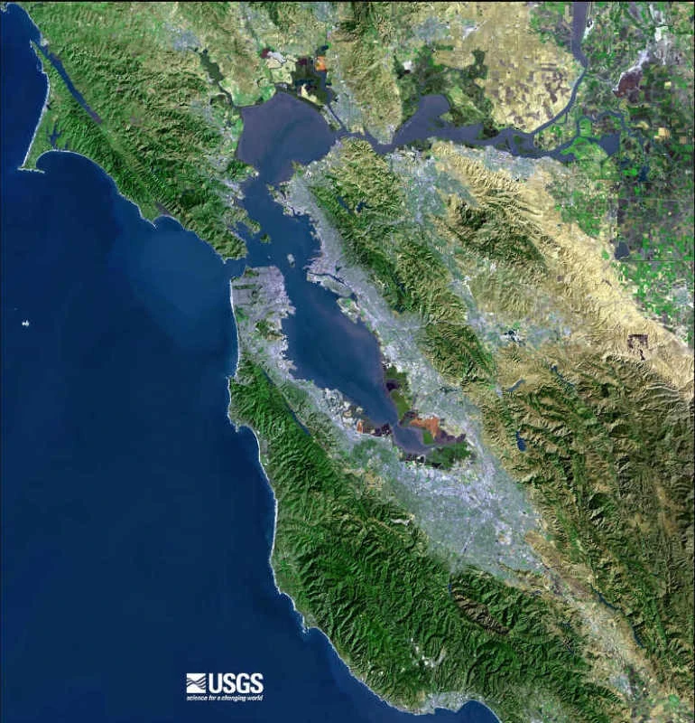
A USGS satellite photo of the Bay Area taken in 1999. The gray areas are signs of urbanization and represent the most populated areas.
The Bay Area is well known for the complexity of its landforms that are the result of millions of years by the forces of plate tectonics, since the region is located in the middle of a meeting point between two plates.[235] Nine out of eleven distinct assemblages have been identified in a single county, Alameda.[236] Diverse assemblages adjoin in complex arrangements due to offsets along the many faults (both active and stable) in the area. As a consequence, many types of rock and soil are found in the region. The oldest rocks are metamorphic rocks that are associated with granite in the Salinian Block west of the San Andreas fault. These were formed from sedimentary rocks of sandstone, limestone, and shale in uplifted seabeds.[237] Volcanic deposits also exist in the Bay Area, left behind by the movement of the San Andreas fault, whose movement sliced a subduction plate and allowed magma to briefly flow to the surface.[238]

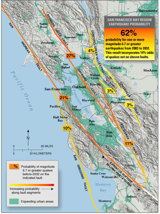
A map displaying each of the seven major fault lines in the Bay Area, and the probability of an M6.7 earthquake or higher occurring on each fault line between 2003 and 2032.
The region has considerable vertical relief in its landscapes that are not in the alluvial plains leading to the bay or in inland valleys. The topography, and geologic history, of the Bay Area can largely be attributed to the compressive forces between the Pacific Plate and the North American plate.[239] The three major ridge structures in the Bay Area, part of the Pacific Coast Range, are all roughly parallel to the major faults. The Santa Cruz Mountains along the San Francisco Peninsula and the Marin Hills in Marin County follow the San Andreas fault, The Berkeley Hills, San Leandro Hills and their southern ridgeline extension through Mission Peak roughly follow the Hayward fault, and the Diablo Range, which includes Mount Diablo and Mount Hamilton and runs along the Calaveras fault.[240]
In total, the Bay Area is traversed by seven major fault systems with hundreds of related faults, all of which are stressed by the relative motion between the Pacific Plate and the North American Plate or by compressive stresses between these plates. The fault systems include the Hayward Fault Zone, Concord-Green Valley Fault, Calaveras Fault, Clayton-Marsh Creek-Greenville Fault, Rodgers Creek Fault, and the San Gregorio Fault.[241] Significant blind thrust faults (faults with near vertical motion and no surface ruptures) are associated with portions of the Santa Cruz Mountains and the northern reaches of the Diablo Range and Mount Diablo. These "hidden" faults, which are not as well known, pose a significant earthquake hazard.[242] Among the more well-understood faults, scientists estimate a 63% probability of a magnitude 6.7 earthquake occurring along either the Hayward, Rogers Creek, or San Andreas fault, with an earthquake more likely to occur in the East Bay.[243] Two of the largest earthquakes in recent history were the 1906 San Francisco earthquake and the 1989 Loma Prieta earthquake.
Hydrography[]
A map of the water features in the San Francisco Bay Area, including the bay and adjacent marshes, ponds, and tributaries.
The Bay Area is home to a complex network of watersheds, marshes, rivers, creeks, reservoirs, and bays that predominantly drain into the San Francisco Bay and Pacific Ocean. The largest bodies of water in the Bay Area are the San Francisco, San Pablo, and Suisun estuaries. Major rivers of the North Bay include the Napa River, the Petaluma River, the Gualala River, and the Russian River; the former two drain into San Pablo Bay, the latter two into the Pacific Ocean. In the South Bay, the Guadalupe River drains into San Francisco Bay near Alviso.[244] There are also several lakes present in the Bay Area, including man-made lakes like Lake Berryessa[245] and natural albeit heavily modified lakes like Lake Merritt.[246]
Prior to the introduction of European agricultural methods, the shores of San Francisco Bay consisted mostly of tidal marshes.[247] Today, the bay has been significantly altered heavily re-engineered to accommodate the needs of water delivery, shipping, agriculture, and urban development, with side effects including the loss of wetlands and the introduction of contaminants and invasive species.[248] Approximately 85% of those marshes have been lost or destroyed, but about 50 marshes and marsh fragments remain.[247] Huge tracts of the marshes were originally destroyed by farmers for agricultural purposes, then repurposed to serve as salt evaporation ponds to produce salt for food and other purposes.[249] Today, regulations limit the destruction of tidal marshes, and large portions are currently being rehabilitated to its natural state.[247]
Government and politics[]
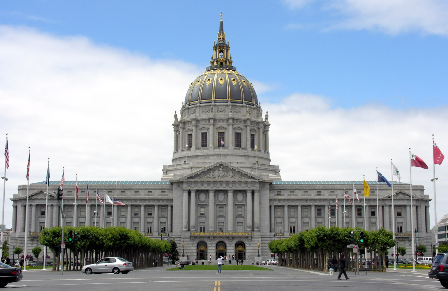

The consolidated city-county government of San Francisco manages its many responsibilities inside the San Francisco City Hall building. In addition to city and county governments, a variety of agencies and districts are also involved in the governance of the Bay Area.
Government in the San Francisco Bay Area consists of multiple actors, including 101 city and nine county governments, a dozen regional agencies, and a large number of single-purpose special districts such as municipal utility districts and transit districts.[250] Incorporated cities are responsible for providing police service, zoning, issuing building permits, and maintaining public streets among other duties.[251] County governments are responsible for elections and voter registration, vital records, property assessment and records, tax collection, public health, agricultural regulations, and building inspections, among other duties.[252][253] Public education is provided by independent school districts, which may be organized as elementary districts, high school districts, unified school districts combining elementary and high school grades, or community college districts, and are managed by an elected school board.[197] A variety of special districts also exist and provide a single purpose, such as delivering public transit in the case of the Bay Area Rapid Transit District,[254] or monitoring air quality levels in the case of the Bay Area Air Quality Management District.[10]
Politics in the Bay Area is widely regarded as one of the most liberal in California and in the United States.[255][256] Since the late 1960s, the Bay Area has cemented its role as the most liberal region in California politics, giving greater support for the center-left Democratic Party's candidates than any other region of the state, even as California trended towards the Democratic Party over time.[257] According to research by the Public Policy Institute of California, the Bay Area and the North Coast counties of Humboldt and Mendocino were the most consistently and strongly liberal areas in California.[257]
According to the California Secretary of State, the Democratic Party holds a voter registration advantage in every congressional district, State Senate district, State Assembly district, State Board of Equalization district, all nine counties, and all but three of the 101 incorporated municipalities in the Bay Area. On the other hand, the center-right Republican Party holds a voter registration advantage in only one State Assembly sub-district (the portion of the 4th in Solano County) and three cities: Atherton, Hillsborough, and Danville.[258] According to the Cook Partisan Voting Index (CPVI), congressional districts the Bay Area tends to favor Democratic candidates by roughly 40 to 50 percentage points, considerably above the mean for California and the nation overall.[259]
| County | Population[260] | Registered voters[261] | Democratic[261] | Republican[261] | D–R spread[261] | American Independent[261] |
Green[261] | Libertarian[261] | Peace and Freedom[261] |
Americans Elect[261] |
Other[261] | No party preference[261] |
|---|---|---|---|---|---|---|---|---|---|---|---|---|
| Alameda | 1,494,876 | 54.6% | 56.4% | 14.1% | +42.3% | 2.0% | 1.2% | 0.5% | 0.4% | 0.0% | 6.0% | 19.5% |
| Contra Costa | 1,037,817 | 58.5% | 50.4% | 21.8% | +24.8% | 2.6% | 0.5% | 0.6% | 0.2% | 0.0% | 0.2% | 23.7% |
| Marin | 250,666 | 61.5% | 54.4% | 18.2% | +36.2% | 2.1% | 1.4% | 0.5% | 0.2% | 0.0% | 0.3% | 12.9% |
| Napa | 135,377 | 56.2% | 46.9% | 24.2% | +22.7% | 3.0% | 0.8% | 0.8% | 0.3% | 0.0% | 0.5% | 23.4% |
| San Francisco | 870,887 | 62.4% | 55.6% | 8.6% | +47.0% | 1.8% | 1.7% | 0.6% | 0.3% | 0.0% | 0.3% | 31.1% |
| San Mateo | 711,622 | 50.7% | 51.3% | 19.4% | +31.9% | 2.1% | 0.7% | 0.5% | 0.2% | 0.0% | 0.2% | 25.5% |
| Santa Clara | 1,762,754 | 46.5% | 45.6% | 21.7% | +23.9% | 2.1% | 0.5% | 0.6% | 0.2% | 0.0% | 0.2% | 29.0% |
| Solano | 411,620 | 51.1% | 48.6% | 25.0% | +23.6% | 2.8% | 0.4% | 0.5% | 0.4% | 0.0% | 0.4% | 22.0% |
| Sonoma | 478,551 | 54.7% | 51.5% | 21.6% | +29.9% | 2.5% | 1.8% | 0.7% | 0.3% | 0.0% | 0.3% | 21.3% |
In U.S. Presidential elections since 1960, the nine-county Bay Area voted for Republican candidates only three times, in all three cases voting for a Californian: in 1972 for Richard Nixon and again in 1980 and 1984 for Ronald Reagan. The last county to vote for a Republican Presidential candidate was Napa county in 1988 for George H. W. Bush. Since then, all nine Bay Area counties have voted consistently for the Democratic candidate.[262] Currently, both of California's U.S. Senators are Democrats, and all twelve U.S. congressional districts located wholly or partially in the Bay Area are represented by a Democratic representative. Additionally, every Bay Area member of the California State Senate and the California State Assembly is a registered Democrat, except for Catharine Baker, who represents California's 16th State Assembly district.[263]
The association between the Bay Area and progressive politics has led the term "San Francisco values" being used by conservative commentators in a pejorative sense to describe the secular progressive culture in the area.[264]
Transportation[]


The Bay Area is served by a variety of rail transit systems, with services provided by ACE, Amtrak, BART, Caltrain, Muni Metro, SMART, and VTA displayed here.
Transportation in the San Francisco Bay Area is reliant on a complex multimodal infrastructure consisting of roads, bridges, highways, rail, tunnels, airports, ferries, and bike and pedestrian paths. The development, maintenance, and operation of these different modes of transportation are overseen by various agencies, including the California Department of Transportation (Caltrans), San Francisco Municipal Transportation Agency, and the Metropolitan Transportation Commission.[265] These and other organizations collectively manage several interstate highways and state routes, two subway networks, two commuter rail agencies, eight trans-bay bridges, transbay ferry service, local bus service,[266] three international airports (San Francisco, San Jose, and Oakland),[267] and an extensive network of roads, tunnels, and paths such as the San Francisco Bay Trail.[268]
The Bay Area hosts an extensive freeway and highway system that is particularly prone to traffic congestion, with one study by Inrix concluding that the Bay Area's traffic was the fourth worst in the world.[269] There are some city streets in San Francisco where gaps occur in the freeway system, partly the result of the Freeway Revolt, which prevented a freeway-only thoroughfare through San Francisco between the San Francisco–Oakland Bay Bridge, the western terminus of Interstate 80, and the southern terminus of the Golden Gate Bridge (U.S. Route 101).[270] Additional damage that occurred in the wake of the 1989 Loma Prieta earthquake resulted in freeway segments being removed instead of being reinforced or rebuilt, leading to the revitalization of neighborhoods such as San Francisco's Embarcadero.[271] The greater Bay Area contains the three principal north-south highways in California: Interstate 5, U.S. Route 101, and California State Route 1. U.S. 101 and State Route 1 directly serve the traditional nine-county region, while Interstate 5 bypasses to the east in San Joaquin County to provide a more direct Los Angeles–Sacramento route. Additional local highways connect the various subregions of the Bay Area together.[272]
There are over two dozen public transit agencies in the Bay Area with overlapping service areas that utilize different modes, with designated connection points between the various operators. Bay Area Rapid Transit (BART), a heavy rail/metro system, operates in four counties and connects San Francisco and Oakland via an underwater tube. Other commuter rail systems link San Francisco with the Peninsula and San Jose (Caltrain), San Jose with the Tri-Valley Area and San Joaquin County (ACE), and Sonoma with Marin County (SMART).[266] In addition, Amtrak provides frequent commuter service between San Jose and the East Bay with Sacramento, and long distance service to other parts of the United States.[273] Muni Metro operates a hybrid streetcar/subway system within the city of San Francisco, and VTA operates a light rail system in Santa Clara County. These rail systems are supplemented by numerous bus agencies and transbay ferries such as Golden Gate Ferry and the San Francisco Bay Ferry. Most of these agencies accept the Clipper Card, a reloadable contactless smart card, as a universal electronic payment system.[266]
See also[]
- List of metropolitan areas of the United States
- Coastal California
- List of companies based in the San Francisco Bay Area
- Lists of San Francisco Bay Area topics
- Timeline of the San Francisco Bay Area
References[]
- ^ "Square Mileage by County". California States Association of Counties. http://www.counties.org/pod/square-mileage-county. Retrieved September 21, 2017.
- ^ Hinrichs, Scott (September 28, 2006). "Mt. Hamilton Lick Observatory". http://www.milpitascamera.com/fieldtrips/report2006-09-02.htm. Retrieved September 21, 2017.
- ^ Kurhi, Eric (December 11, 2014). "San Jose: Overwhelmed pumps led to Alviso flooding; residents say it's a 'wake-up call'". San Jose Mercury News. http://www.mercurynews.com/bay-area-news/ci_27182429/san-jose-overwhelmed-pumps-led-alviso-flooding-residents.
- ^ "Counties Population Totals Tables: 2010–2017". United States Census Bureau, Population Division. March 2018. https://factfinder.census.gov/faces/tableservices/jsf/pages/productview.xhtml?src=bkmk. Retrieved March 22, 2017.
- ^ "Metropolitan and Micropolitan Statistical Area Population Totals Tables: 2010–2017". United States Census Bureau, Population Division. March 2018. https://factfinder.census.gov/faces/tableservices/jsf/pages/productview.xhtml?src=bkmk. Retrieved March 22, 2018.
- ^ "Area Code Map for Northern California/Bay Area". White Pages. https://www.whitepages.com/maps/NCA. Retrieved September 21, 2017.
- ^ Demographia (April 2016). Demographia World Urban Areas (12th ed.). http://www.demographia.com/db-worldua.pdf. Retrieved November 17, 2016.
- ^ a b c Template:Citejournal
- ^ "The Nine Regional Water Quality Control Boards in California". California Water Boards. http://www.waterboards.ca.gov/publications_forms/publications/factsheets/docs/region_brds.pdf. Retrieved September 18, 2017.
- ^ a b "About the Air District". Bay Area Air Quality Management District. http://www.baaqmd.gov/about-the-air-district. Retrieved September 18, 2017.
- ^ "Welcome page". San Francisco Bay Restoration Authority. http://sfbayrestore.org/. Retrieved September 18, 2017.
- ^ "Nine Bay Area counties". Metropolitan Transportation Commission. http://mtc.ca.gov/about-mtc/what-mtc/nine-bay-area-counties. Retrieved September 18, 2017.
- ^ "ABAG Members". Association of Bay Area Governments. http://abag.ca.gov/overview/members.html. Retrieved September 18, 2017.
- ^ "Bay Area Census – Counties". Bay Area Census. http://www.bayareacensus.ca.gov/counties/counties.htm. Retrieved September 18, 2017.
- ^ "San Francisco-San Jose-Oakland Designated Media Market Data". Truck Ads. http://www.truckads.com/Designated-Market/San-Francisco-Oakland-San-Jose.htm. Retrieved September 18, 2017.
- ^ "OMB Bulletin No. 13-01: Revised Delineations of Metropolitan Statistical Areas, Micropolitan Statistical Areas, and Combined Statistical Areas, and Guidance on Uses of the Delineations of These Areas". United States Office of Management and Budget. February 28, 2013. https://obamawhitehouse.archives.gov/sites/default/files/omb/bulletins/2013/b-13-01.pdf. Retrieved April 17, 2013.
- ^ Crawford, Sabrina (January 31, 2006). Newcomer's Handbook for Moving to And Living in the San Francisco Bay Area: Including San Jose, Oakland, Berkeley, And Palo Alto. First Books. pp. 9–182. ISBN 978-0-912301-63-1. https://books.google.com/books?id=oRubZ8uW1FYC&pg=PA130. Retrieved February 9, 2013.
- ^ Nolte, Carl (November 7, 2015). "Peninsula a surprise find south of S.F.". San Francisco Chronicle. http://www.sfchronicle.com/bayarea/nativeson/article/Peninsula-a-surprise-find-south-of-S-F-6617485.php. Retrieved September 18, 2017.
- ^ Crawford, Sabrina (January 31, 2006). Newcomer's Handbook for Moving to And Living in the San Francisco Bay Area: Including San Jose, Oakland, Berkeley, And Palo Alto. First Books. pp. 99–129. ISBN 978-0-912301-63-1. https://books.google.com/books?id=oRubZ8uW1FYC&pg=PA130. Retrieved February 9, 2013.
- ^ Crawford, Sabrina (January 31, 2006). Newcomer's Handbook for Moving to And Living in the San Francisco Bay Area: Including San Jose, Oakland, Berkeley, And Palo Alto. First Books. pp. 130–156. ISBN 978-0-912301-63-1. https://books.google.com/books?id=oRubZ8uW1FYC&pg=PA130. Retrieved February 9, 2013.
- ^ "San Jose Population 2018 (Demographics, Maps, Graphs)". http://worldpopulationreview.com/us-cities/san-jose-population/.
- ^ Crawford, Sabrina (January 31, 2006). Newcomer's Handbook for Moving to And Living in the San Francisco Bay Area: Including San Jose, Oakland, Berkeley, And Palo Alto. First Books. pp. 157–182. ISBN 978-0-912301-63-1. https://books.google.com/books?id=oRubZ8uW1FYC&pg=PA130. Retrieved February 9, 2013.
- ^ Crawford, Sabrina (January 31, 2006). Newcomer's Handbook for Moving to And Living in the San Francisco Bay Area: Including San Jose, Oakland, Berkeley, And Palo Alto. First Books. pp. 78–98. ISBN 978-0-912301-63-1. https://books.google.com/books?id=oRubZ8uW1FYC&pg=PA130. Retrieved February 9, 2013.
- ^ a b Billiter, Bill (January 1, 1985). "3,000-Year-Old Connection Claimed : Siberia Tie to California Tribes Cited". Los Angeles Times (Los Angeles). Archived from the original on November 28, 2014. https://web.archive.org/web/20141128090656/http://articles.latimes.com/1985-01-01/local/me-10267_1_tribes. Retrieved September 22, 2017.
- ^ Stewart, Suzanne B. (November 2003). "Archaeological Research Issues For The Point Reyes National Seashore – Golden Gate National Recreation Area" (PDF). Sonoma State University – Anthropological Studies Center. p. 11. http://www.sonoma.edu/asc/projects/pointreyes/overview2.pdf. Retrieved September 22, 2017.
- ^ a b c d "Visitors: San Francisco Historical Information". City and County of San Francisco. Archived from the original on March 1, 2006. https://web.archive.org/web/20060301022510/http://sfgov.org/site/visitor_index.asp?id=8091. Retrieved June 10, 2008.
- ^ "Moraga Explores The Valley". Cagen Web. http://www.cagenweb.com/sanjoaquin/moraga.pdf. Retrieved September 22, 2017.
- ^ a b "Introduction". Early History of the California Coast. National Park Service. https://www.nps.gov/nr/travel/ca/intro.htm. Retrieved September 22, 2017.
- ^ Lee Foster (October 1, 2001). Northern California History Weekends. Globe Pequot. p. 13. ISBN 978-0-7627-1076-8. https://books.google.com/books?id=8VA0GAmdjK4C. Retrieved December 26, 2011.
- ^ a b c The Virtual Museum of the City of San Francisco (July 16, 2004). "From the 1820s to the Gold Rush". The Virtual Museum of the City of San Francisco. Archived from the original on October 22, 2009. https://web.archive.org/web/20091022224825/http://www.sfmuseum.org/hist1/early.html. Retrieved September 22, 2017.
- ^ Barkan, Elliott (2013). Immigrants in American History: Arrival, Adaptation, and Integration. Santa Barbara: ABC-CLIO. ISBN 9781598842197.
- ^ Harris, Ron (November 14, 2005). "Crews Unearth Shipwreck on San Francisco Condo Project". Associated Press. http://www.constructionequipmentguide.com/story.asp?story=6287&headline=Crews. Retrieved September 22, 2017.
- ^ Castillo, Edward D.. "Short Overview of California Indian History". California Native American Heritage Commission. Archived from the original on March 4, 2010. https://web.archive.org/web/20100304114034/http://nahc.ca.gov/califindian.html. Retrieved October 9, 2017.
- ^ Wilson, Dotson; Ebbert, Brian S. (2006) (PDF). California's Legislature (2006 ed.). Sacramento: California State Assembly. pp. 149–154. OCLC 70700867. http://www.leginfo.ca.gov/pdf/caleg11.pdf.
- ^ "Historical Census Statistics On Population Totals By Race, 1790 to 1990, and By Hispanic Origin, 1970 to 1990, For Large Cities And Other Urban Places In The United States". U.S. Census Bureau. Archived from the original on August 6, 2012. https://www.webcitation.org/69hd5KAIE?url=http://www.census.gov/population/www/documentation/twps0076/twps0076.html. Retrieved December 18, 2011.
- ^ "The Transcontinental Railroad: Transforing California and the Nation". UC Davis. http://railroad.historyproject.ucdavis.edu/about/content-scope-and-approach/. Retrieved September 22, 2017.
- ^ "The Great 1906 San Francisco Earthquake". United States Geological Survey. https://earthquake.usgs.gov/earthquakes/events/1906calif/18april/. Retrieved September 24, 2017.
- ^ "Casualties and damage after the 1906 Earthquake". United States Geological Survey. https://earthquake.usgs.gov/earthquakes/events/1906calif/18april/casualties.php. Retrieved September 24, 2017.
- ^ a b Rodgers, Paul (April 15, 2006). "Ripples from 1906 San Francisco quake felt even today". The Seattle Times. http://old.seattletimes.com/html/nationworld/2002931392_calquake15.html. Retrieved September 24, 2017.
- ^ "San Francisco Gold Rush Banking – 1849". The Virtual Museum of the City of San Francisco. June 24, 2004. http://www.sfmuseum.net/hist9/banking.html. Retrieved September 24, 2017.
- ^ Standen, Amy (May 27, 2012). "75 Years Ago, A Deadly Day On The Golden Gate". National Public Radio. https://www.npr.org/2012/05/27/153778083/75-years-later-building-the-golden-gate-bridge. Retrieved September 24, 2017.
- ^ Vorderbrueggen, Lisa (August 9, 2013). "Building the Bay Bridge: 1930s vs. today". San Jose Mercury News. http://www.mercurynews.com/2013/08/09/building-the-bay-bridge-1930s-vs-today/. Retrieved September 24, 2017.
- ^ a b c Nolte, Carl (May 28, 2012). "World War II reshaped the Bay Area and its people". San Francisco Chronicle. http://www.sfgate.com/bayarea/article/World-War-II-reshaped-the-Bay-Area-and-its-people-3589894.php. Retrieved September 24, 2017.
- ^ "U.N. Charter signed". History Channel. http://www.history.com/this-day-in-history/u-n-charter-signed. Retrieved September 24, 2017.
- ^ "Treaty of Peace with Japan (with two declarations). Signed at San Francisco, on 8 September 1951". United Nations. September 8, 1951. https://treaties.un.org/doc/Publication/UNTS/Volume%20136/volume-136-I-1832-English.pdf. Retrieved September 24, 2017.
- ^ a b Ashbolt, Anthony (2013). A Cultural History of the Radical Sixties in the San Francisco Bay Area. Routledge. p. 4.
- ^ "Scott McKenzie, 1960s counter-culture singer, dies at 73". The Daily Telegraph. August 20, 2012. https://www.telegraph.co.uk/culture/music/music-news/9487213/Scott-McKenzie-1960s-counter-culture-singer-dies-at-73.html. Retrieved September 24, 2017.
- ^ Robertson, Mark. "Looking Back: Canning in the Valley of Heart's Delight". San Jose Public Library. https://www.sjpl.org/blog/looking-back-canning-valley-hearts-delight. Retrieved September 24, 2017.
- ^ "Shockley Semiconductor". Public Broadcasting Station. http://www.pbs.org/transistor/background1/corgs/shocksemi.html. Retrieved September 24, 2017.
- ^ The New York Times (October 20, 1989). "The California Quake: The Bay Bridge; Damage to Link Across Bay Is More Serious Than Thought". The New York Times. https://www.nytimes.com/1989/10/20/us/california-quake-bay-bridge-damage-link-across-bay-more-serious-than-thought.html.
- ^ "1990 and 1980 Census Counts for Cities with 1990 Population Greater Than 100,000". United States Census Bureau. https://www.census.gov/population/www/censusdata/files/c1008090pc.txt. Retrieved August 8, 2014. "1980: San Francisco = 678974, San Jose = 629400. 1990: San Jose = 782248, San Francisco = 723959"
- ^ Clark, Tara (May 13, 2015). "When Did The Stock Market Crash? A List Of U.S. Markets’ Worst Declines". ETF Daily News. https://etfdailynews.com/2015/05/13/when-did-the-stock-market-crash-a-list-of-u-s-markets-worst-declines-dow-jones/. Retrieved September 24, 2017.
- ^ a b c d e "Bay Area Census – Bay Area Data". Bayareacensus.ca.gov. http://www.bayareacensus.ca.gov/bayarea.htm. Retrieved November 4, 2011.
- ^ "Gays rush to San Francisco to wed". BBC News. February 15, 2004. http://news.bbc.co.uk/2/hi/americas/3488005.stm. Retrieved October 1, 2014.
- ^ Wildermuth, John (November 5, 2008). "Voters backing same-sex marriage ban". San Francisco Chronicle. http://www.sfgate.com/news/article/Voters-backing-same-sex-marriage-ban-3186400.php. Retrieved October 9, 2017.
- ^ Jones, Carolyn (January 9, 2009). "Oakland storekeepers tell of night of terror". San Francisco Chronicle. Archived from the original on January 16, 2009. https://web.archive.org/web/20090116095506/http://www.sfgate.com/cgi-bin/article.cgi?f=%2Fc%2Fa%2F2009%2F01%2F09%2FMNC3155VI6.DTL. Retrieved January 10, 2009.
- ^ "Occupy Oakland: The Oscar Grant / Frank Ogawa Plaza Issue". San Francisco Chronicle. October 30, 2011. http://blog.sfgate.com/abraham/2011/10/30/occupy-oakland-the-oscar-grant-frank-ogawa-plaza-issue/. Retrieved October 9, 2017.
- ^ Sulek, Julia Prodis, Lisa M. Krieger, and Tatiana Sanchez (January 22, 2017). "Women’s March: Huge Bay Area turnout as California resistance takes hold". San Jose Mercury News. http://www.mercurynews.com/2017/01/21/womens-march-huge-bay-area-turnout-as-california-resistance-takes-hold/. Retrieved October 9, 2017.
- ^ McPhate, Mike (September 25, 2017). "California Today: Bay Area Athletes Clash With Trump". The New York Times. https://www.nytimes.com/2017/09/25/us/california-today-bay-area-athletes-clash-with-trump.html. Retrieved October 9, 2017.
- ^ Barmann, Jay (September 5, 2017). "Bay Area Residents React To Trump Killing 'Dreamers' Program, Protests Planned". SFist. Archived from the original on October 13, 2017. https://web.archive.org/web/20171013202334/http://sfist.com/2017/09/05/bay_area_residents_react_to_trump_k.php. Retrieved October 9, 2017.
- ^ Albright, Thomas (1985). Art in the San Francisco Bay Area, 1945–1980: An Illustrated History. University of California Press. pp. 15–17. https://books.google.com/books?id=aGN3vXcZl74C.
- ^ Albright, Thomas (1985). Art in the San Francisco Bay Area, 1945–1980: An Illustrated History. University of California Press. p. 57. https://books.google.com/books?id=aGN3vXcZl74C.
- ^ Albright, Thomas (1985). Art in the San Francisco Bay Area, 1945–1980: An Illustrated History. University of California Press. p. 81–82. https://books.google.com/books?id=aGN3vXcZl74C.
- ^ "PIXAR: 25 Years of Animation". Oakland Museum of California. http://museumca.org/exhibit/pixar-25-years-animation. Retrieved September 21, 2017.
- ^ Zorthian, Julia (November 19, 2015). "How Toy Story Changed Movie History". TIME Magazine. http://time.com/4118006/20-years-toy-story-pixar/. Retrieved September 21, 2017.
- ^ French, Alex and Howie Khan (June 2015). "The Untold Story of ILM, a Titan That Forever Changed Film". Wired. https://www.wired.com/2015/05/inside-ilm/. Retrieved September 21, 2017.
- ^ a b T. Gitlin, The Sixties: Years of Hope, Days of Rage, (New York, 1993), p.215–217
- ^ a b Selvin, Joel (January 30, 2009). "The Chronicle's Bay Area musical history tour". San Francisco Chronicle. http://www.sfgate.com/bayarea/article/The-Chronicle-s-Bay-Area-musical-history-tour-3174389.php. Retrieved September 21, 2017.
- ^ a b Fuller, Thomas (July 20, 2016). "The Loneliness of Being Black in San Francisco". The New York Times. https://www.nytimes.com/2016/07/21/us/black-exodus-from-san-francisco.html?mcubz=1. Retrieved September 18, 2017.
- ^ Grow, Korey (November 13, 2014). "John Fogerty Addresses 'Fortunate Son' Concert for Valor Controversy". Rolling Stone. https://www.rollingstone.com/music/news/john-fogerty-addresses-fortunate-son-concert-for-valor-controversy-20141113. Retrieved September 21, 2017.
- ^ "Santana". Rock and Roll Hall of Fame. Retrieved April 16, 2013.
- ^ Galluci, Michael (April 15, 2016). "Carlos Santana Wants Journey to Get Back Together With Steve Perry". Ultimate Classic Rock. http://ultimateclassicrock.com/carlos-santana-journey-steve-perry/. Retrieved September 21, 2017.
- ^ Smith, Chris (July 2011). "Rehab of a strung-out musical scene". San Francisco Magazine. http://www.sanfranmag.com/story/rehab-of-a-strung-out-musical-scene. Retrieved August 7, 2011.; Smith, Chris (July 6, 2011). "Our avant-garde metal scene". ca-smith.net. http://www.ca-smith.net/blog/2011/07/our-avant-garde-metal-scene/. Retrieved August 7, 2011.
- ^ Collins, Hattie (October 20, 2006). "Ghostridin' the whip". The Guardian. http://arts.guardian.co.uk/features/story/0,,1926601,00.html. Retrieved September 21, 2017.
- ^ Lang, Cady (October 18, 2017). "Lil B the Based God Talks NBA Curses and Hopes, 2017 Season". Time. http://time.com/4984913/lil-b-the-based-god-nba-2017-interview/. Retrieved October 28, 2017.
- ^ a b Brooks, John (November 14, 2011). "Interview: Oakland Hip Hop History and the Current Scene". KQED. https://ww2.kqed.org/news/2011/11/14/interview-oakland-locals-eric-arnold-on-the-oakland-rap-scene/. Retrieved September 21, 2017.
- ^ "Bay Area Music Groups". San Francisco Classical Voice. https://www.sfcv.org/events-calendar/organization-profiles?field_organization_type_value=orchestras. Retrieved September 21, 2017.
- ^ Coakley, Jacob (September 24, 2014). "Theatre Bay Area Announces Finalists for Inaugural Awards". Stage Directions. http://stage-directions.com/6405-theatre-bay-area-announces-finalists-for-inaugural-awards.html. Retrieved September 21, 2017.
- ^ "Fact Sheet: About Theatre Bay Area". Theatre Bay Area. https://c.ymcdn.com/sites/theatrebayarea.site-ym.com/resource/resmgr/Press_Room/TBA_Fact_Sheet_UPDATED_FINAL.pdf. Retrieved September 21, 2017.
- ^ "The Special Tony® Award for Regional Theatre". American Theatre Critics Association. http://americantheatrecritics.org/tony-award/. Retrieved September 21, 2017.
- ^ Fields, Regina (July 28, 2016). "Here’s Why the Bay Area Theater Scene Is Amazing". The Bold Italic. https://thebolditalic.com/heres-why-the-bay-area-theater-scene-is-amazing-right-now-34935fc03255. Retrieved September 21, 2017.
- ^ D'Souza, Karen (June 28, 2017). "Ten Bay Area stage actors we love". San Jose Mercury News. http://www.mercurynews.com/2013/09/30/ten-bay-area-stage-actors-we-love/. Retrieved September 21, 2017.
- ^ "ACT's Young Conservatory". American Conservatory Theatre. http://www.act-sf.org/home/conservatory/young_conservatory.html. Retrieved September 21, 2017.
- ^ "Theatre Lessons in the Bay Area". Bay Area Kid's Fun. http://www.bayareakidfun.com/theater-lessons-in-the-bay-area/. Retrieved September 21, 2017.
- ^ "Local Television Market Universe Estimates" (XLS). September 22, 2007. Archived from the original on September 27, 2007. https://web.archive.org/web/20070927200433/http://www.nielsenmedia.com/nc/nmr_static/docs/2007-2008_DMA_Ranks.xls. Retrieved June 15, 2008.
- ^ "Arbitron Radio Market Rankings: Spring 2008". Arbitron. April 16, 2008. Archived from the original on August 1, 2007. http://www.arbitron.com/radio_stations/mm001050.asp. Retrieved June 14, 2008.
- ^ Greb, Gordon and Mike Adams (August 15, 2003). Charles Herrold, Inventor of Radio Broadcasting. McFarland & Company. p. 129.
- ^ "About KALW". KALW. http://kalw.org/about-kalw#stream/0. Retrieved September 19, 2017.
- ^ "KPIX Retrospective: 1948-5". San Francisco State University. 1968. https://diva.sfsu.edu/collections/sfbatv/bundles/187344. Retrieved September 19, 2017.
- ^ Phillips, Robin J (Feb 28, 2011). "Bloomberg launches West Coast show from San Francisco". Reynolds Center. Archived from the original on April 14, 2013. https://archive.is/20130414120012/http://businessjournalism.org/2011/02/28/bloomberg-launches-west-coast-show-from-san-francisco/. Retrieved July 25, 2011.
- ^ "Top 30 Public Radio Subscribers – Winter 2004 Arbitron" (PDF). Radio Research Consortium. Arbitron Media Research. June 17, 2004. Archived from the original on April 23, 2005. https://web.archive.org/web/20050423215537/http://www.pacifica.org/documents/pdf/ArbitronRatingsWinter2004.pdf. Retrieved June 14, 2008.
- ^ "About Us". KPOO. http://www.kpoo.com/about. Retrieved September 19, 2017.
- ^ "Top 200 Newspapers by Largest Reported Circulation". Audit Bureau of Circulations. March 31, 2007. Archived from the original on August 13, 2007. https://web.archive.org/web/20070813073544/http://www.accessabc.com/products/top200.htm. Retrieved June 14, 2008.
- ^ Rosenberg, Scott (March 21, 2000). "The San Francisco Examiner, 1887–2000". Salon. Archived from the original on June 27, 2009. https://web.archive.org/web/20090627064603/http://archive.salon.com/media/feature/2000/03/21/examiner/index.html. Retrieved June 15, 2008.
- ^ Nolte, Carl (November 22, 2000). "Examiner Staff Ends an Era With Tears, Newsroom Tales". San Francisco Chronicle (Hearst Communications): p. A-1. http://www.sfgate.com/cgi-bin/article.cgi?f=/c/a/2000/11/22/MN121380.DTL&hw=san+francisco+examiner&sn=005&sc=498. Retrieved June 15, 2008.
- ^ Hochschild, Adam (May–June 2001). "The First 25 Years". Mother Jones. https://www.motherjones.com/politics/2001/05/first-25-years/. Retrieved September 19, 2017.
- ^ Hua, Vanessa (August 3, 2004). "Newspaper war in the Bay Area: Ming Pao becomes 6th Chinese-language daily". San Francisco Chronicle (Hearst Communications): p. B-1. http://www.sfgate.com/cgi-bin/article.cgi?f=/c/a/2004/08/03/BAGI781MM91.DTL. Retrieved June 14, 2008.
- ^ "The Peninsula's only homegrown Spanish-language newspaper is finding its place in the world.". January 11, 2001. http://www.montereycountyweekly.com/news/local_news/the-peninsula-s-only-homegrown-spanish-language-newspaper-is-finding/article_a2dae28c-fcb5-50ec-bfab-8d006a687fb0.htm. Retrieved September 19, 2017.
- ^ "About Levi's Stadium". levisstadium.com. http://levisstadium.com/about#/comparison. Retrieved January 30, 2014.
- ^ "Super Bowl XVI Game Recap". Nfl.com. January 25, 1982. http://www.nfl.com/superbowl/history/recap/sbxvi. Retrieved August 21, 2012.
- ^ "Super Bowl XIX Game Recap". Nfl.com. January 21, 1985. http://www.nfl.com/superbowl/history/recap/sbxix. Retrieved August 21, 2012.
- ^ "Super Bowl 46 at NFL.com – Official Site of the National Football League". Nfl.com. January 23, 1989. http://www.nfl.com/superbowl/history/recap/sbxxiii. Retrieved August 21, 2012.
- ^ "Super Bowl XXIV Game Recap". Nfl.com. January 29, 1990. http://www.nfl.com/superbowl/history/recap/sbxxiv. Retrieved August 21, 2012.
- ^ "Super Bowl XXIX Game Recap". Nfl.com. January 30, 1995. http://www.nfl.com/superbowl/history/recap/sbxxix. Retrieved August 21, 2012.
- ^ "Super Bowl XLVII Game Recap". Nfl.com. http://www.nfl.com/videos/nfl-game-highlights/0ap2000000135690/Super-Bowl-XLVII-Ravens-vs-49ers-highlights. Retrieved July 2, 2017.
- ^ a b "Oracle Arena and Oakland Coliseum About Us". Coliseum.com. http://www.coliseum.com/about-us/history. Retrieved September 21, 2017.
- ^ Rosenthal, Gregg (March 27, 2017). "NFL team owners approve Raiders' move to Las Vegas". National Football League. http://www.nfl.com/news/story/0ap3000000795413/article/nfl-team-owners-approve-raiders-move-to-las-vegas. Retrieved March 27, 2017.
- ^ "Super Bowl XI Game Recap". Nfl.com. January 10, 1997. http://www.nfl.com/superbowl/history/recap/sbxi. Retrieved August 21, 2012.
- ^ "Super Bowl XV Game Recap". Nfl.com. January 26, 1981. http://www.nfl.com/superbowl/history/recap/sbxv. Retrieved August 21, 2012.
- ^ "Super Bowl XVIII Game Recap". Nfl.com. January 23, 1984. http://www.nfl.com/superbowl/history/recap/sbxviii. Retrieved August 21, 2012.
- ^ "Super Bowl II Game Recap". Nfl.com. January 15, 1968. http://www.nfl.com/superbowl/history/recap/sbii. Retrieved August 21, 2012.
- ^ "Super Bowl XXXVII Game Recap". Nfl.com. January 27, 2003. http://www.nfl.com/superbowl/history/recap/sbxxxvii. Retrieved August 21, 2012.
- ^ "AT&T Park | SFGiants.com: Ballpark". Sanfrancisco.giants.mlb.com. June 19, 2012. http://sanfrancisco.giants.mlb.com/sf/ballpark/index.jsp. Retrieved August 21, 2012.
- ^ a b Schaal, Eric (November 4, 2016). "5 MLB Teams With the Most World Series Titles". Sports Cheat Sheet. https://www.cheatsheet.com/sports/5-mlb-teams-world-series-titles.html/?a=viewall. Retrieved September 18, 2017.
- ^ "Warriors History Index". NBA. http://www.nba.com/warriors/team_history_index.html/. Retrieved September 18, 2017.
- ^ "San Jose Earthquakes eyeing new stadium in 2012 | MLS News". tribalfootball.com. http://www.tribalfootball.com/articles/san-jose-earthquakes-eyeing-new-stadium-2012-1359501. Retrieved August 22, 2012.
- ^ "Development History". San Jose Barracudas. http://www.sjbarracuda.com/team/development-history. Retrieved September 18, 2017.
- ^ "San Jose Giants Team Info". San Jose Giants. http://www.milb.com/content/page.jsp?sid=t476&ymd=20100219&content_id=8098792&vkey=team4. Retrieved September 2, 2015.
- ^ "The Pacific Association of Baseball Clubs". The Pacifics. http://www.pacificsbaseball.com/index.php/team-info/pacific-association. Retrieved September 18, 2017.
- ^ "NCAA Members by Division". NCAA. http://web1.ncaa.org/onlineDir/exec2/divisionListing?sortOrder=0&division=1. Retrieved September 18, 2017.
- ^ Katz, Andy (May 3, 2013). "Sources: Utah St., SJSU joining MWC". ESPN. http://www.espn.com/college-sports/story/_/id/7883895/utah-state-san-jose-state-joining-mountain-west-conference-2013-2014-according-sources. Retrieved September 21, 2017.
- ^ "Cal, Stanford get pumped up for The Big Game | abc7news.com". Abclocal.go.com. November 15, 2011. http://abclocal.go.com/kgo/story?section=news/sports/college/football&id=8433343. Retrieved August 22, 2012.
- ^ "Scout.com: The Big Game: Cal vs. Stanford". California.scout.com. November 22, 2008. Archived from the original on May 25, 2017. https://web.archive.org/web/20170525002822/http://www.scout.com/college/california/story/814436-the-big-game-cal-vs-stanford?s=166. Retrieved August 22, 2012.
- ^ Weintraub, David (September 29, 2004). Afoot and Afield: San Francisco Bay Area: A Comprehensive Hiking Guide. Wilderness Press. p. 1.
- ^ "Mt. Hamilton Challenge & Ascent Bicycle Tours". Pedalera Bicycle Club. http://www.hillsidegraphics.com/hamilton-challenge/. Retrieved April 4, 2008.
- ^ "Bicycle Network Facilities". Commuting and Resources. SF Municipal Transportation Authority. May 12, 2008. Archived from the original on October 22, 2007. https://web.archive.org/web/20071022043109/http://www.sfmta.com/cms/bcomm/3180.html. Retrieved June 15, 2008.
- ^ Hübler, Eric (2008). "The Fittest and Fattest Cities in America". Men's Fitness (American Media, Inc). Archived from the original on October 11, 2008. https://web.archive.org/web/20081011203124/http://www.mensfitness.com/city_rankings/454. Retrieved June 15, 2008.
- ^ "St Francis Yacht Club". http://www.stfyc.com/. Retrieved March 26, 2013.
- ^ "Golden Gate Yacht Club". http://www.ggyc.com/. Retrieved March 26, 2013.
- ^ "About South Beach Yacht Club". http://www.southbeachyachtclub.org/Default.aspx?p=DynamicModule&pageid=28&ssid=100049&vnf=1. Retrieved March 26, 2013.
- ^ "POPANERS: 2010–2017". United States Census Bureau, Population Division. March 2018. https://factfinder.census.gov/faces/tableservices/jsf/pages/productview.xhtml?src=bkmk. Retrieved March 22, 2018.
- ^ "U.S. Immigrant Population by State and County" (in en). migrationpolicy.org. February 4, 2014. http://www.migrationpolicy.org/programs/data-hub/charts/us-immigrant-population-state-and-county.
- ^ "Census 2010: Table 3A – Total Population by Race (Hispanic exclusive) and Hispanic or Latino: 2010" (Excel). California Department of Finance. Archived from the original on November 24, 2011. https://web.archive.org/web/20111124020222/http://www.dof.ca.gov/research/demographic/state_census_data_center/census_2010/documents/2010Census_Table3A_RedistrictingFile.xls. Retrieved June 11, 2010.
- ^ Willet, Megan (July 8, 2013). "The Most Diverse Cities in United States". Retrieved on September 11, 2014.
- ^ "Judaism (estimated) Metro Areas (2000)". The Association of Religion Data Archives. Archived from the original on November 23, 2009. https://web.archive.org/web/20091123122848/http://www.thearda.com/QuickLists/QuickList_195c.asp. Retrieved December 1, 2009.
- ^ Sanchez, Tatiana (September 6, 2016). "Report: Bay Area Latino population growth has slowed". San Jose Mercury News. http://www.mercurynews.com/2016/09/08/report-bay-area-latino-population-growth-has-slowed/. Retrieved September 19, 2017.
- ^ DelVecchio, Rick (May 24, 2001). "Hispanics move from S.F., San Jose into suburbs / Numbers climb fast throughout state". San Francisco Chronicle. http://www.sfgate.com/bayarea/article/Hispanics-move-from-S-F-San-Jose-into-suburbs-2918330.php. Retrieved September 19, 2017.
- ^ "The Mission – A Barrio of Many Colors". KQED. https://www.kqed.org/w/hood/mission/barrio.html. Retrieved September 19, 2017.
- ^ Fagan, Mark (March 22, 2012). "Asian population swells in Bay Area, state, nation". San Francisco Chronicle. http://www.sfgate.com/bayarea/article/Asian-population-swells-in-Bay-Area-state-nation-3425777.php. Retrieved September 18, 2017.
- ^ "The Asian Population: 2010". U.S. Census. pp. 12–13. https://www.census.gov/prod/cen2010/briefs/c2010br-11.pdf. Retrieved September 19, 2017.
- ^ "QT-P3 – Race and Hispanic or Latino Origin: 2010". 2010 United States Census Summary File 1. United States Census Bureau. http://factfinder.census.gov/faces/tableservices/jsf/pages/productview.xhtml?pid=DEC_10_SF1_QTP3. Retrieved July 11, 2011.
- ^ "Training and Education /PET". Filipino-American Law Enforcement Officers Association. Archived from the original on January 16, 2013. https://web.archive.org/web/20130116021343/http://www.faleo.org/index.php?option=com_content&view=article&id=54&Itemid=62. Retrieved April 28, 2012.
- ^ "Indian-American population is fastest-growing minority group". East Bay Times. May 12, 2011. http://www.eastbaytimes.com/2011/05/12/indian-american-population-is-fastest-growing-minority-group/. Retrieved September 19, 2017.
- ^ Estrella, Cicero A. (February 2004). "S.F.'s 'Little Saigon' / Stretch of Larkin Street named for Vietnamese Americans". San Francisco Chronicle. http://www.sfgate.com/cgi-bin/article.cgi?f=/c/a/2004/02/16/BAG2751OP81.DTL. Retrieved March 6, 2010.
- ^ "Asian American Maps". Pew Research. http://www.pewsocialtrends.org/asianamericans-maps/. Retrieved September 19, 2017.
- ^ Eaton, Joe and Ron Sullivan (May 31, 2014). "Taste of Laos in Richmond school garden". San Francisco Chronicle. http://www.sfgate.com/homeandgarden/thedirt/article/Taste-of-Laos-in-Richmond-school-garden-4298443.php#photo-4220806. Retrieved September 19, 2017.
- ^ a b "East Palo Alto". Bay Area Census. http://www.bayareacensus.ca.gov/cities/EastPaloAlto.htm. Retrieved September 19, 2017.
- ^ "South Park, Santa Rosa's vibrant, ever-changing corner". The Press Democrat. http://www.pressdemocrat.com/article/20090613/ARTICLES/906139924?p=4&tc=pg. Retrieved July 8, 2011.
- ^ "Vallejo". Bay Area Census. http://www.bayareacensus.ca.gov/cities/Vallejo.htm. Retrieved September 19, 2017.
- ^ "Richmond". Bay Area Census. http://www.bayareacensus.ca.gov/cities/Richmond.htm. Retrieved September 19, 2017.
- ^ Community Facts. (2010, October 5). [United States Census Bureau]. Retrieved from factfinder.census.gov/faces/nav/jsf/pages/community_facts.xhtml#.
- ^ a b c Scott, W. Richard, and Michael W. Krist. Higher Education and Silicon Valley: Connected but Conflicted. Johns Hopkins University Press, 2017.
- ^ "Pleasanton tops county in median household income". Inside Bay Area. Archived from the original on June 6, 2011. https://web.archive.org/web/20110606141112/http://www.insidebayarea.com/sanmateocountytimes/localnews/ci_4259660. Retrieved October 15, 2006.
- ^ a b Levin, Matt (August 11, 2016). "California’s rich-poor gap: The reality may surprise you". CalMatters. https://calmatters.org/articles/income-inequality-in-california-may-not-look-like-you-think-it-does-and-why-that-may-be-a-good-thing/. Retrieved October 9, 2017.
- ^ Holmes, Natalie and Alan Berube (January 14, 2016). "City and metropolitan inequality on the rise, driven by declining incomes". Brookings Institution. https://www.brookings.edu/research/city-and-metropolitan-inequality-on-the-rise-driven-by-declining-incomes/. Retrieved October 9, 2017.
- ^ DeBare, Ilana (March 6, 2008). "47 Bay Area billionaires on Forbes list". The San Francisco Chronicle. http://www.sfgate.com/default/article/47-Bay-Area-billionaires-on-Forbes-list-3224006.php.
- ^ "Capgemini Announces 2010 U.S. Metro Wealth Index". Business Wire. August 3, 2010. http://www.businesswire.com/news/home/20100803006707/en/Capgemini-Announces-2010-U.S.-Metro-Wealth-Index. Retrieved November 4, 2011.
- ^ a b c d Sernoffsky , Evan and Kurtis Alexander (September 28, 2015). "U.S. crime drops again, but gains uneven in Bay Area". San Francisco Chronicle. http://www.sfchronicle.com/crime/article/U-S-crime-drops-again-but-gains-uneven-in-Bay-6536129.php. Retrieved September 20, 2017.
- ^ a b Veklerov, Kimberly (September 28, 2016). "FBI report reveals safest and most dangerous Bay Area cities". San Francisco Chronicle. http://www.sfgate.com/crime/article/FBI-report-reveals-safest-and-most-dangerous-Bay-9399281.php. Retrieved September 20, 2017.
- ^ Salonga, Robert (December 31, 2016). "San Jose: Street violence rises, burglary drops in scattered crime profile for 2016". San Jose Mercury News. http://www.mercurynews.com/2016/12/31/san-jose-street-violence-rises-burglary-drops-in-scattered-crime-profile-for-2016/. Retrieved September 20, 2017.
- ^ Bulwa, Demian (May 27, 2005). "SAN FRANCISCO / Sureño gang's threat growing in Bay Area / Widow's apartment is at heart of group's Mission District turf". San Francisco Chronicle. http://www.sfgate.com/bayarea/article/SAN-FRANCISCO-Sure-o-gang-s-threat-growing-in-2667647.php. Retrieved March 29, 2014.
- ^ Albert Samaha (September 26, 2012). "Crip-less: S.F.'s Dislike of Franchises Extends to Street Gangs – Page 1 – News – San Francisco". SF Weekly. http://www.sfweekly.com/2012-09-26/news/crips-gangs-sfpd-bloods-bayview-hunters-point/. Retrieved July 29, 2013.
- ^ Mary Spicuzza (August 1, 2007). "Enter The Dragon". SF Weekly. http://archives.sfweekly.com/sanfrancisco/enter-the-dragon-head/Content?oid=2163615. Retrieved September 5, 2016.
- ^ Vanessa Hua (October 7, 2006). "Golden Dragon Closes and owes a million". San Francisco Chronicle. http://sfgate.com/cgi-bin/article.cgi?f=/c/a/2006/10/07/BAGMMLKK661.DTL. Retrieved December 6, 2011.
- ^ "Oakland Boosts 'Operation Ceasefire' After Baby, Father Killed « CBS San Francisco". Sanfrancisco.cbslocal.com. August 8, 2013. http://sanfrancisco.cbslocal.com/2013/08/08/oakland-boosts-operation-ceasefire-after-baby-father-killed/. Retrieved August 8, 2013.
- ^ Template:Citejournal
- ^ Analysis, US Department of Commerce, BEA, Bureau of Economic (September 20, 2017). "Bureau of Economic Analysis" (in EN-US). https://www.bea.gov/newsreleases/regional/gdp_metro/2017/pdf/gdp_metro0917.pdf.
- ^ "Bay Area GDP Watch 2016". September 2017. http://www.bayareaeconomy.org/bay-area-gdp-watch/. Retrieved January 29, 2018.
- ^ "Fortune 500". Fortune. http://fortune.com/fortune500/2016/. Retrieved September 20, 2017.
- ^ Downey, Rosie (August 4, 2017). "Largest Bay Area manufacturers". American City Business Journals. https://www.bizjournals.com/sanjose/subscriber-only/2017/08/04/largest-bay-area-manufacturers.html. Retrieved October 6, 2017.
- ^ "North American Container Traffic, 2009 Port Ranking". http://aapa.files.cms-plus.com/Statistics/NORTHAMERICANPORTCONTAINERTRAFFIC2009.pdf. Retrieved August 11, 2010.
- ^ Kester, Jennifer. "Your Top California Wine-Tasting Itinerary: Napa and Sonoma". Forbes. https://www.forbes.com/sites/forbestravelguide/2017/08/10/your-top-california-wine-tasting-itinerary-napa-and-sonoma/#4b75a142b8f3. Retrieved September 20, 2017.
- ^ Torres, Blanca (April 28, 2017). "Housing’s tale of two cities: Seattle builds, S.F. lags". San Francisco Business Times. Archived from the original. Error: If you specify
|archiveurl=, you must also specify|archivedate=. https://web.archive.org/web/20170502005754/https://www.bizjournals.com/sanfrancisco/news/2017/04/28/san-francisco-seattle-housing-production-pipelines.html. Retrieved December 4, 2017. "
"So how can smaller Seattle make so much more housing happen than San Francisco? Developers active in both cities and officials who have worked in both point to structural differences that outweigh the demographic similarities. In San Francisco, development issues are routinely subject to consideration by neighborhood bodies, approval by the city planning commission and often ratification by its board of supervisors, with opportunities for decisions to be appealed. Seattle’s approval process is much more streamlined...The city’s planning commission is strictly a policy entity. It does not approve or reject projects. The city council weighs in on projects only in rare cases. [In S.F.]...he thinks that the California Environmental Quality Act, known as CEQA, makes it too easy for residents to sue projects, effectively holding them up for years or blocking them.
- ^ Clark, Patrick (June 23, 2017). "Why Can’t They Build More Homes Where the Jobs Are?". Bloomberg. Archived from the original. Error: If you specify
|archiveurl=, you must also specify|archivedate=. https://web.archive.org/web/20170828201133/https://www.bloomberg.com/news/articles/2017-06-23/why-can-t-they-build-more-homes-where-the-jobs-are. Retrieved December 1, 2017. "
"San Francisco's metropolitan area added 373,000 net new jobs in the last five years—but issued permits for only 58,000 units of new housing. The lack of new construction has exacerbated housing costs in the Bay Area, making the San Francisco metro among the cruelest markets in the U.S. Over the same period, Houston added 346,000 jobs and permitted 260,000 new dwellings, five times as many units per new job as San Francisco.
- ^ Lucas, Scott (October 12, 2016). "We found which Bay Area cities aren't pulling their weight on housing". Vox Media. Archived from the original. Error: If you specify
|archiveurl=, you must also specify|archivedate=. https://web.archive.org/web/20161102192555/https://sf.curbed.com/2016/10/12/12945854/bay-area-cities-jobs-housing-san-jose-palo-alto-sf. Retrieved December 1, 2017. - ^ Labor Force Statistics from the Current Population Survey (Report). United States Department of Labor - Bureau of Labor Statistics. November 4, 2017. https://data.bls.gov/timeseries/LNS12000000. Retrieved November 4, 2017.
- ^ Annual Estimates of Housing Units for the United States, Regions, Divisions, States, and Counties: April 1, 2010 to July 1, 2016 (Report). United States Census Bureau. July 1, 2016. https://factfinder.census.gov/bkmk/table/1.0/en/PEP/2016/PEPANNHU. Retrieved November 1, 2017.
- ^ Bee, C. A. (2013). The Geographic Concentration of High-Income Households: 2007-2011 (No. ACSBR/11-23). United States Census Bureau.
- ^ Bay Area burden. [electronic resource] : examining the costs and impacts of housing and transportation on Bay Area residents, their neighborhoods and the environment. (2009). Washington, DC : Urban Land Institute, c2009.
- ^ Alamo, C., Uhler, B., & O'Malley, M. (2015). California's high housing costs : causes and consequences. Sacramento, CA : Legislative Analyst's Office, March 17, 2015.
- ^ Scheinin, Richard (August 12, 2017). "Bay Area real estate: To buy a median priced home, you now need income over $179,000". San Jose Mercury News. http://www.mercurynews.com/2017/08/11/bay-area-real-estate-to-buy-a-median-priced-home-you-now-need-income-over-179000/. Retrieved September 20, 2017.
- ^ a b Bay Area Burden. [Electronic Resource] : Examining the Costs and Impacts of Housing and Transportation on Bay Area Residents, Their Neighborhoods and the Environment. Washington, DC : Urban Land Institute, c2009., 2009. EBSCOhost
- ^ a b Quigley, J. M., Raphael, S., & Smolensky, E. (2001). Homelessness in California. San Francisco, Calif. : Public Policy Institute of California, 2001.
- ^ a b Suzuki, L. (2016, June 28). How Many People Live on Our Streets? San Francisco Chronicle. Retrieved from projects.sfchronicle.com/sf-homeless/numbers/.
- ^ Dougherty, Connor and Andrew Burton (August 17, 2017). "A 2:15 Alarm, 2 Trains and aBus Get Her to Work by 7 A.M.". The New York Times. https://www.nytimes.com/2017/08/17/business/economy/san-francisco-commute.html?mcubz=1. Retrieved September 20, 2017.
- ^ Bender, Kristen (December 25, 2017). "Flying to work cheaper than living in the Bay Area for some". KTVU. http://www.ktvu.com/news/flying-to-work-cheaper-than-living-in-the-bay-area-for-some. Retrieved January 17, 2017.
- ^ "About SCU – History". Santa Clara University. https://www.scu.edu/aboutscu/history/. Retrieved October 19, 2017.
- ^ "USF – Our History". University of San Francisco. https://www.usfca.edu/about-usf/who-we-are/our-history. Retrieved October 19, 2017.
- ^ "San José State University: About SJSU: 1857–1879". San José State University. http://www.sjsu.edu/about_sjsu/history/timeline/1857/. Retrieved October 29, 2013.
- ^ "Cities with the Most College-Educated Residents". The New York Times. https://www.nytimes.com/interactive/2012/05/31/us/education-in-metro-areas.html?mcubz=1. Retrieved September 20, 2017.
- ^ "Bay Area universities rank among best in the US". ABC News. September 13, 2016. http://abc7news.com/education/bay-area-universities-rank-among-best-in-the-us/1509952/. Retrieved September 20, 2017.
- ^ "America's Best Graduate Schools: Best Medical Schools". U.S. News and World Report. 2010. Archived from the original on April 21, 2010. https://web.archive.org/web/20100421213522/http://grad-schools.usnews.rankingsandreviews.com/best-graduate-schools/top-medical-schools/primary-care-rankings. Retrieved July 25, 2010.
- ^ "UCSF Medical Center in San Francisco". U.S. News and World Report. https://health.usnews.com/best-hospitals/area/ca/ucsf-medical-center-6930043. Retrieved July 25, 2010.
- ^ "Hastings Quick Facts". University of California, Hastings College of the Law. http://www.uchastings.edu/?pid=37. Retrieved August 30, 2006.
- ^ "SF State Fast Facts". SFSU. Archived from the original on September 3, 2017. https://web.archive.org/web/20170903202226/http://www.sfsu.edu/future/visit/facts.html. Retrieved September 21, 2017.
- ^ "How does your community college stack up?". CNNMoney. http://money.cnn.com/pf/college/community-colleges/. Retrieved September 20, 2017.
- ^ a b Individual State Descriptions: 2007, 2007 Census of Governments, United States Census Bureau, November 2012, pp. 25–26, http://www2.census.gov/govs/cog/isd_book.pdf
- ^ "What Are Charter Schools?". California Charter Schools Association. http://www.ccsa.org/understanding/what-are-charter-schools.html. Retrieved September 20, 2017.
- ^ "California High Schools". US News & World Report. https://www.usnews.com/education/best-high-schools/search?state-urlname=california. Retrieved September 20, 2017.
- ^ a b "Climate of San Francisco". Golden Gate Weather Services. 2009. http://ggweather.com/sf/narrative.html. Retrieved September 19, 2017.
- ^ a b c Miller, Miguel (April 1999). "Climate of San Jose". National Weather Service. http://www.wrh.noaa.gov/mtr/sfd_sjc_climate/sjc/SJC_CLIMATE3.php. Retrieved September 19, 2017.
- ^ a b Gilliam, Harold (July–September 2002). "Cutting Through the Fog: Demystifying the Summer Spectacle". Bay Nature.
- ^ a b c d e Gillam, Harold (July 9, 2001). "Weather as varied as the people / Land and fog build summer microclimates". San Francisco Chronicle. http://www.sfgate.com/bayarea/article/Weather-as-varied-as-the-people-Land-and-fog-2900468.php. Retrieved September 19, 2001.
- ^ Template:WRCC
- ^ Template:WRCC
- ^ Template:WRCC
- ^ Template:WRCC
- ^ Template:WRCC
- ^ "San Francisco Bay Area and Delta Protection". Center for Biological Diversity. http://www.biologicaldiversity.org/campaigns/san_francisco_bay_area_and_delta_protection/. Retrieved September 19, 2017.
- ^ "Current California Ocean Recreational Fishing Regulations". California Department of Fish and Wildlife. https://www.wildlife.ca.gov/Fishing/Ocean/Regulations/Fishing-Map/San-Francisco. Retrieved September 19, 2017.
- ^ "From Salt Production to Salt Marsh". NASA Earth Observatory. February 11, 2016. https://earthobservatory.nasa.gov/IOTD/view.php?id=87379. Retrieved September 19, 2017.
- ^ Reiter, Matthew E. et al., (April 2011). "A Monitoring Plan for Wintering Shorebids in the San Francisco Bay". California Landscape Conservation Cooperative. http://data.prbo.org/apps/pfss/uploads/Reports/SanFranciscoBayShorebirdMonitoringPlan_v1.0_FULL_PRBO_2010CALCC.pdf. Retrieved September 19, 2017.
- ^ "Threatened and Endangered species". South Bay Restoration Project. http://www.southbayrestoration.org/Fact%20Sheets/FS5.html. Retrieved September 19, 2017.
- ^ Central California Coast Steelhead DPS (Report). NOAA's National Marine Fisheries Service Northwest Regional Office. http://www.nwr.noaa.gov/ESA-Salmon-Listings/Salmon-Populations/Steelhead/STCCC.cfm. Retrieved February 15, 2010.
- ^ Greg Miller (January 2010). "In Central California, Coho Salmon Are on the Brink". Science 327 (5965): 512–3. DOI:10.1126/science.327.5965.512. PMID 20110475. Retrieved on Feb 15, 2010.
- ^ (2008) "Mercury in the San Francisco Estuary". Rev Environ Contam Toxicol 194: 29–54. DOI:10.1007/978-0-387-74816-0_2. PMID 18069645.
- ^ Skinner, John E. (1962). An Historical Review of the Fish and Wildlife Resources of the San Francisco Bay Area (The Mammalian Resources). California Department of Fish and Game, Water Projects Branch Report no. 1. Sacramento, California: California Department of Fish and Game. Archived from the original on July 26, 2011. https://web.archive.org/web/20110726035239/http://www.estuaryarchive.org/archive/skinner_1962/.
- ^ Suzanne Stewart and Adrian Praetzellis (November 2003). Archeological Research Issues for the Point Reyes National Seashore – Golden Gate National Recreation Area (Report). Anthropological Studies Center, Sonoma State University. p. 335. http://www.sonoma.edu/asc/projects/pointreyes/overview4.pdf. Retrieved January 10, 2010.
- ^ Clark, Samantha (August 12, 2016). "Leave it to beavers: California joins other states in embracing the rodent". San Jose Mercury News. http://www.mercurynews.com/2014/12/21/leave-it-to-beavers-california-joins-other-states-in-embracing-the-rodent/. Retrieved September 19, 2017.
- ^ "Get Outside!". San Francisco Chronicle. April 1966. Archived from the original on June 30, 2009. https://web.archive.org/web/20090630084732/http://www.sfgate.com/getoutside/1996/apr/rwanimals.html. Retrieved March 6, 2011.
- ^ "Blue Oak Ranch Reserve". University of California. Archived from the original on May 12, 2011. https://web.archive.org/web/20110512020828/http://nrs.ucop.edu/reserves/blue_oak_ranch/blue_oak.htm. Retrieved March 6, 2011.
- ^ "Sea Lions and the Sea Lion Story". Pier 39. https://www.pier39.com/the-sea-lion-story/. Retrieved September 19, 2017.
- ^ Tokuda, Wendy; Hall, Richard; Wakiyama, Hanako (ill.) (1986). Humphrey the lost whale: a true story. Union City, California: Heian Intl Publishing Company. ISBN 0-89346-270-5. OCLC 779021889.
- ^ Roger, AnnaMarie. "Dolphins and Porpoises in San Francisco Bay". Our Sausalito. http://www.oursausalito.com/fun-sausalito-activities/marine-mammal-center/dolphins-harbor-porpoise-project.html. Retrieved September 21, 2017.
- ^ Yagi, Randy (September 5, 2015). "Best Places For Bird Watching Near Bay Area". KPIX-5. http://sanfrancisco.cbslocal.com/top-lists/best-places-for-bird-watching-near-bay-area/. Retrieved September 19, 2017.
- ^ Rendon, JIm (Nov–Dec 1999). "Owl Be Damned:Developers plow into the homes of the burrowing owl". Metro, Silicon Valley's Weekly Newspaper. http://www.metroactive.com/papers/metro/11.24.99/cover/species5-9947.html.
- ^ Joe Eaton (Jan 14, 2010). "Wild Neighbors: Antioch Owls Face Evicition". Berkeley Daily Planet. http://www.berkeleydailyplanet.com/issue/2010-01-14/article/34485?headline=Wild-Neighbors-Antioch-Owls-Face-Evicition. Retrieved January 14, 2010.
- ^ a b c Krieger, Lisa M. (April 3, 2017). "In Bay Area, bald eagles breed and soar once more". San Jose Mercury News. http://www.mercurynews.com/2017/04/03/in-bay-area-bald-eagles-breed-and-soar-once-more/. Retrieved September 19, 2017.
- ^ Lisa M. Krieger (March 23, 2012). "Eagles reappear in San Mateo County after nearly century absence". San Jose Mercury News. http://www.mercurynews.com/bay-area-news/ci_20243906/eagles-reappear-san-mateo-after-nearly-century-absence#.T28ziNcgZcM.email. Retrieved March 25, 2012.
- ^ (1927) "Directory to the bird-life of the San Francisco Bay region". Pacific Coast Avifauna 18. Retrieved on May 22, 2016.
- ^ (1989) "Bald Eagle and Osprey, in Proceedings of the Western Raptor Management Symposium and Workshop". National Wildlife Federation Scientific and Technical Series 12: 66–82.
- ^ William G. Bousman (January 1, 2007). Breeding Bird Atlas of Santa Clara County, California. Santa Clara Valley Audubon Society. ISBN 978-0-9796038-0-8. https://books.google.com/books?id=qYNFAQAAIAAJ.
- ^ (September 2014) "Status of Ospreys Nesting on San Francisco Bay". Western Birds 45: 190–198. Retrieved on May 22, 2016.
- ^ Rubio, Tena (November 27, 2015). "Like It or Not, Wild Turkeys Proliferate in East Bay". KQED. http://ww2.kqed.org/news/2015/11/27/like-it-or-not-wild-turkeys-proliferate-in-east-bay. Retrieved November 27, 2015.
- ^ Sloan, Doris (2006). Geology of the San Francisco Bay Region. University of California Press. pp. 2.
- ^ Preliminary geologic map emphasizing bedrock formations in Alameda County, California: A digital database USGS Publication
- ^ Sloan, Doris (October 1, 2001). "What, and where, are the oldest rocks in the Bay Area?". Bay Nature Magazine. https://baynature.org/article/what-and-where-are-the-oldest-rocks-in-the-bay-area/. Retrieved September 19, 2017.
- ^ Alden, Andrew (April 11, 2011). "Bay Area Volcanoes". KQED. https://ww2.kqed.org/quest/2011/04/28/bay-area-volcanoes/. Retrieved September 19, 2017.
- ^ Anderson, David W et al. "San Andreas Fault and Coastal Geology from Half Moon Bay to Fort Funston: Crustal Motion, Climate Change, and Human Activity". United States Geological Survey. https://pubs.usgs.gov/bul/b2188/b2188ch4.pdf. Retrieved September 20, 2017.
- ^ California Geological Survey (2010). Fault Activity Map of California (Map). http://maps.conservation.ca.gov/cgs/fam/. Retrieved September 20, 2017.
- ^ "The San Andreas and Other Bay Area Faults". United States Geological Survey. https://earthquake.usgs.gov/earthquakes/events/1906calif/virtualtour/bayarea.php. Retrieved September 20, 2017.
- ^ Perlman, David (December 25, 2003). "Bay Area home to thrust faults / Some are hidden from scientists' view". San Francisco Chronicle. http://www.sfgate.com/bayarea/article/Bay-Area-home-to-thrust-faults-Some-are-hidden-2544890.php. Retrieved September 20, 2017.
- ^ "Earthquake Hazards of The Bay Area Today". United States Geological Survey. https://earthquake.usgs.gov/earthquakes/events/1868calif/virtualtour/modern.php. Retrieved September 20, 2017.
- ^ "San Francisco Bay Delta Watershed Map". ArcGIS. https://www.arcgis.com/apps/OnePane/basicviewer/index.html?appid=387531ac0c094da5b6139b890958fca6. Retrieved September 20, 2017.
- ^ "Lake Berryessa". U.S. Department of the Interior. https://www.usbr.gov/mp/ccao/berryessa/index.html. Retrieved September 20, 2017.
- ^ "About Lake Merritt". The Lake Merritt Institute. http://www.lakemerrittinstitute.org/about_lake.htm. Retrieved September 20, 2017.
- ^ a b c "A Brief History of the San Francisco Bay Tidal Marshes". Stanford University. https://web.stanford.edu/~sophiarc/WetlandsHistory.html. Retrieved September 20, 2017.
- ^ Kimmerer, W. (2004). "Open water process of the San Francisco Estuary: from physical forcing to biological responses. " San Francisco Estuary and Watershed Science 2(1). pp. 1–13.
- ^ Paul, Roger (August 12, 2016). "Massive new wetlands restoration reshapes San Francisco Bay". San Jose Mercury News. http://www.mercurynews.com/2013/08/29/massive-new-wetlands-restoration-reshapes-san-francisco-bay/. Retrieved September 20, 2017.
- ^ Terplan, Egon (February 20, 2013). "Strengthening the Bay Area’s regional governance". SPUR. p. 2. https://www.spur.org/sites/default/files/publications_pdfs/Strengthening_Regional_Governance.pdf. Retrieved September 20, 2017.
- ^ California Government Code Title 4, Government of Cities
- ^ Baldassare, Mark (1998). When Government Fails: The Orange County Bankruptcy. Public Policy Institute of California/University of California Press. pp. 67–68. ISBN 0-520-21486-2. https://books.google.com/books?id=sDs4WZV0SRsC&pg=PA67.
- ^ Janiskee, Brian P.; Masugi, Ken (2011). Democracy in California: Politics and Government in the Golden State (3rd ed.). Rowman & Littlefield Publishers. p. 105. ISBN 978-1-4422-0338-9. https://books.google.com/books?id=23Y3Nxs0qWgC&pg=PA105.
- ^ "A History of BART: The Concept is Born". Bay Area Rapid Transit. http://www.bart.gov/about/history. Retrieved September 18, 2017.
- ^ Barabak, Mark Z. (March 31, 2017). "How Trump supporters survive in blue California: 'You kind of keep your head down'". Los Angeles Times. http://www.latimes.com/politics/la-na-trump-california-supporters-2017-story.html. Retrieved September 18, 2017.
- ^ Fuller, Thomas (July 2, 2017). "California’s Far North Deplores ‘Tyranny’ of the Urban Majority". New York Times. https://www.nytimes.com/2017/07/02/us/california-far-north-identity-conservative.html?mcubz=1. Retrieved September 18, 2017.
- ^ a b McGhee, Eric and Daniel Krimm (February 2012). "California's Political Geography". Public Policy Institute of California. http://www.ppic.org/publication/californias-political-geography/. Retrieved September 18, 2017.
- ^ "Report of Registration". California Secretary of State. February 10, 2017. http://elections.cdn.sos.ca.gov/ror/ror-pages/ror-odd-year-2017/politicalsub.pdf. Retrieved September 18, 2017.
- ^ "PVI Map and District List". The Cook Political Report. https://cookpolitical.com/pvi-map-and-district-list. Retrieved September 18, 2017.
- ^ U.S. Census Bureau. American Community Survey, 2011 American Community Survey 5-Year Estimates, Table B02001. American FactFinder. Retrieved October 26, 2013.
- ^ a b c d e f g h i j k California Secretary of State. Report of Registration as of February 10, 2017.
- ^ "Dave Leip's Atlas of U.S. Presidential Election Results". Dave Leip's Atlas. http://uselectionatlas.org/RESULTS/. Retrieved September 18, 2017.
- ^ Wildermuth, John (May 8, 2016). "Catharine Baker, Bay Area’s only GOP lawmaker, tries to keep seat". San Francisco Chronicle. http://www.sfchronicle.com/politics/article/Catharine-Baker-Bay-Area-s-only-GOP-lawmaker-7421831.php. Retrieved September 18, 2017.
- ^ Garofoli, Joe (November 3, 2006). "Three Dirty Words: San Francisco Values". San Francisco Chronicle. http://www.sfgate.com/cgi-bin/article.cgi?file=/c/a/2006/11/03/MNGCEM5H4N1.DTL. Retrieved May 21, 2008.
- ^ "California Department of Transportation". Metropolitan Transportation Commission. http://mtc.ca.gov/about-mtc/what-mtc/partner-agencies/california-department-transportation. Retrieved September 18, 2017.
- ^ a b c Amin, Ratna and Sara Barz (April 2015). "Seamless Transit". SPUR. pp. 4–9. http://www.spur.org/sites/default/files/publications_pdfs/SPUR_Seamless_Transit.pdf. Retrieved September 18, 2017.
- ^ Reed, Ted (June 12, 2017). "All Three Bay Area Airports Grow as United Expands Frisco Hub and Oakland Gets Two Spain Flights". TheStreet. https://www.thestreet.com/story/14173660/1/all-three-bay-area-airports-grow-as-united-expands-frisco-hub-and-oakland-gets-two-spain-flights.html. Retrieved September 18, 2017.
- ^ "About the Trail". San Francisco Bay Trail. http://baytrail.org/about-the-trail/. Retrieved September 18, 2017.
- ^ Cabanatuan, Michael (February 27, 2017). "SF traffic ranks as 4th worst in world". San Francisco Chronicle. http://www.sfgate.com/bayarea/article/SF-traffic-ranks-as-4th-worst-in-world-10960858.php. Retrieved September 18, 2017.
- ^ Atkins, Martin (September 9, 2012). "San Francisco's Freeway Revolt". http://urbanscars.com/san-francisco-freeway-revolt/. Retrieved September 18, 2017.
- ^ "11 Most Endangered: San Francisco Embarcadero | National Trust for Historic Preservation". https://savingplaces.org/places/sf-embarcadero.
- ^ Thomas Brothers (2009). California Road Atlas (Map).
- ^ "About Amtrak California". Amtrak. http://amtrakcalifornia.com/about/. Retrieved September 20, 2017.
External links[]
- Discover the Bay Area website run by Discover California
- Bay Area Tourism Guide by the San Francisco Chamber of Commerce
| |||||||||||||||||||||||||
| |||||||||||||||||||||||
|