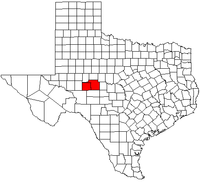
Map of Texas highlighting the San Angelo metropolitan area.
The San Angelo Metropolitan Statistical Area is a metropolitan area in West Texas that covers two counties - Tom Green and Irion. As of the 2010 census, the MSA had a population of 111,823.[1]
Counties[]
Communities[]
Cities[]
- San Angelo (Principal City)
- Mertzon
Census-designated places[]
- Christoval
- Grape Creek
Unincorporated places[]
- Barnhart
- Carlsbad
- Knickerbocker
- Sherwood
- Tankersley
- Vancourt
- Veribest
- Wall
- Water Valley
Demographics[]
As of the census[2] of 2010, there were 111,823 people, 42,984 households, and 28,198 families residing within the MSA. The racial makeup of the MSA was 84.4% White, 4.8% African American, 1.4% Native American, 1.5% Asian, 0.02% Pacific Islander, 10.7% from other races, and 1.3% from two or more races. Hispanic or Latino of any race were 35.5% of the population.
See also[]
- List of cities in Texas
- List of museums in West Texas
- Texas census statistical areas
- List of Texas metropolitan areas
References[]
- ^ "Profile of General Population and Housing Characteristics: 2010 (CBSA-EST2009-01)" (CSV). 2010 Population Estimates. United States Census Bureau, Population Division. http://factfinder2.census.gov/faces/tableservices/jsf/pages/productview.xhtml?pid=DEC_10_DP_DPDP1&prodType=table. Retrieved 2010-07-22.
- ^ "American FactFinder". United States Census Bureau. http://factfinder2.census.gov. Retrieved 2008-01-31.
| This page uses content from the English language Wikipedia. The original content was at San Angelo, Texas metropolitan area. The list of authors can be seen in the page history. As with this Familypedia wiki, the content of Wikipedia is available under the Creative Commons License. |
