| ||||||||||||||
| Russell County, Kansas | |
 Russell County Courthouse in Russell
| |
 Location in the state of Kansas | |
 Kansas's location in the U.S. | |
| Founded | February 26, 1867 |
|---|---|
| Named for | Alva P. Russell |
| Seat | Russell |
| Area - Total - Land - Water |
898.98 sq mi (2,328 km²) 884.68 sq mi (2,291 km²) 14.30 sq mi (37 km²), 1.59% |
| Population - (2010) - Density |
6,970 7.7/sq mi (3.0/km²) |
| Time zone | Central: UTC-6/-5 |
| Website | www.Russell.KansasGov.com |
Russell County (standard abbreviation: RS) is a county located in the U.S. state of Kansas. The county's population was 6,970 for the 2010 census.[1] The largest city and county seat is Russell.
Law and government[]
Russell County was a prohibition, or "dry", county until the Kansas Constitution was amended in 1986 and voters approved the sale of alcoholic liquor by the individual drink with a 30% food sales requirement.[2]
Geography[]
According to the 2000 census, the county has a total area of 898.98 square miles (2,328.3 km2), of which 884.68 square miles (2,291.3 km2) (or 98.41%) is land and 14.30 square miles (37.0 km2) (or 1.59%) is water.[3]
Adjacent counties[]
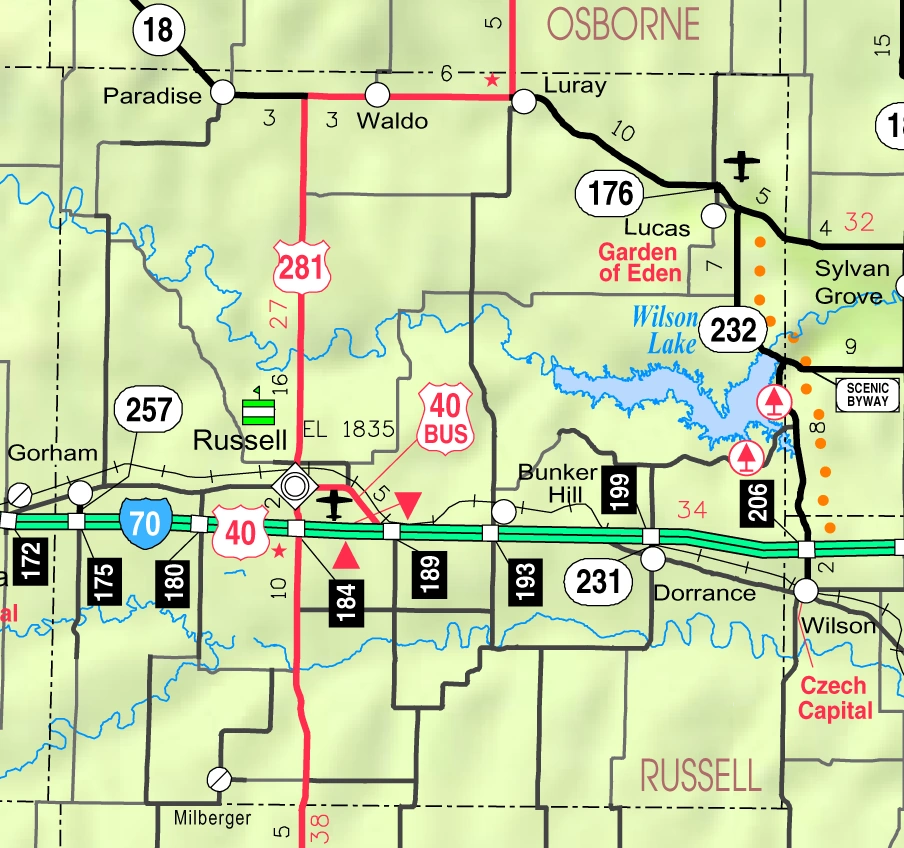
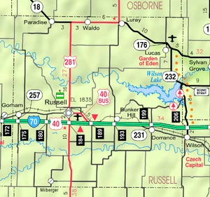
2005 KDOT Map of Russell County (map legend)
- Osborne County (north)
- Lincoln County (east)
- Ellsworth County (southeast)
- Barton County (south)
- Rush County (southwest)
- Ellis County (west)
Highways[]
The city of Russell is the junction of Interstate 70, a major east-west highway through the Midwestern United States, and U.S. Route 281, which begins at the United States-Canadian border in North Dakota and ends at the U.S.-Mexican border in Texas. I-70 also runs through Gorham on the western end of the county and Dorrance on the eastern end. Hays is 30 miles (48 km) west of Russell and Salina is 67 miles (108 km) east of Russell.
Further along I-70, Russell is approximately 250 miles (400 km) west of Kansas City, Missouri and 360 miles (580 km) east of Denver, Colorado.
K-18, a major east-west state highway in northern Kansas, enters from Osborne County to the west and runs through Paradise before joining up with US 281 through Waldo. US 281 and K-18 split again at the city limits of Luray, and K-18 continues east through Lucas and into Lincoln County. US 281 heads north into Osborne County.
South of I-70, US 281 heads into Barton County and towards the city of Great Bend.
Demographics[]
| Historical populations | |||
|---|---|---|---|
| Census | Pop. | %± | |
| 1900 | 8,489 | ||
| 1910 | 10,800 | 27.2% | |
| 1920 | 10,748 | −0.5% | |
| 1930 | 11,045 | 2.8% | |
| 1940 | 13,464 | 21.9% | |
| 1950 | 13,406 | −0.4% | |
| 1960 | 11,348 | −15.4% | |
| 1970 | 9,428 | −16.9% | |
| 1980 | 8,868 | −5.9% | |
| 1990 | 7,835 | −11.6% | |
| 2000 | 7,370 | −5.9% | |
| 2010 | 6,970 | −5.4% | |

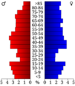
Age pyramid
As of the census[4] of 2000, there were 7,370 people, 3,207 households, and 2,020 families residing in the county. The population density was 8 people per square mile (3/km²). There were 3,871 housing units at an average density of 4 per square mile (2/km²). The racial makeup of the county was 97.58% White, 0.50% Black or African American, 0.56% Native American, 0.33% Asian, 0.01% Pacific Islander, 0.27% from other races, and 0.75% from two or more races. 0.91% of the population were Hispanic or Latino of any race.
There were 3,207 households out of which 25.40% had children under the age of 18 living with them, 53.40% were married couples living together, 7.10% had a female householder with no husband present, and 37.00% were non-families. 32.80% of all households were made up of individuals and 16.80% had someone living alone who was 65 years of age or older. The average household size was 2.23 and the average family size was 2.83.
In the county the population was spread out with 22.40% under the age of 18, 5.80% from 18 to 24, 23.30% from 25 to 44, 24.30% from 45 to 64, and 24.10% who were 65 years of age or older. The median age was 44 years. For every 100 females there were 92.50 males. For every 100 females age 18 and over, there were 88.70 males.
The median income for a household in the county was $29,284, and the median income for a family was $40,355. Males had a median income of $25,916 versus $17,957 for females. The per capita income for the county was $17,073. About 9.10% of families and 12.00% of the population were below the poverty line, including 13.80% of those under age 18 and 8.50% of those age 65 or over.
Cities and towns[]
Incorporated cities[]
Name and population (2004 estimate):
- Russell, 4,431 (county seat)
- Lucas, 427
- Gorham, 339
- Dorrance, 194
- Luray, 191
- Bunker Hill, 97
- Paradise, 63
- Waldo, 47
Townships[]
Russell County is divided into twelve townships. The city of Russell is considered governmentally independent and is excluded from the census figures for the townships. In the following table, the population center is the largest city (or cities) included in that township's population total, if it is of a significant size.
| Township | FIPS | Population center |
Population | Population density /km² (/sq mi) |
Land area km² (sq mi) |
Water area km² (sq mi) |
Water % | Geographic coordinates |
|---|---|---|---|---|---|---|---|---|
| Big Creek | 06700 | 515 | 3 (7) | 186 (72) | 0 (0) | 0.03% | ||
| Center | 12150 | 255 | 1 (2) | 359 (139) | 9 (3) | 2.41% | ||
| Fairfield | 22200 | 42 | 0 (1) | 104 (40) | 0 (0) | 0.03% | ||
| Fairview | 22650 | 526 | 3 (7) | 185 (71) | 1 (1) | 0.77% | ||
| Grant | 28100 | 159 | 1 (3) | 135 (52) | 0 (0) | 0.18% | ||
| Lincoln | 41125 | 147 | 2 (4) | 94 (36) | 0 (0) | 0% | ||
| Luray | 43275 | 270 | 1 (4) | 183 (71) | 2 (1) | 0.94% | ||
| Paradise | 54350 | 169 | 0 (1) | 372 (144) | 1 (0) | 0.16% | ||
| Plymouth | 56925 | 319 | 1 (3) | 255 (98) | 24 (9) | 8.50% | ||
| Russell | 61850 | 89 | 1 (2) | 127 (49) | 0 (0) | 0.03% | ||
| Waldo | 74600 | 108 | 1 (2) | 186 (72) | 0 (0) | 0.19% | ||
| Winterset | 80125 | 75 | 1 (2) | 93 (36) | 0 (0) | 0.05% |
Education[]
Schools in Russell County have experienced major change in the 2010-11 school year. USD 407, which previously served all of Russell County except the northwest and southeast corners, retracted its footprint and will only serve the cities of Russell, Gorham and Bunker Hill and areas to the south of Interstate 70.
Lucas-Luray High School, previously operated by USD 407, was acquired by the school district in Sylvan Grove in western Lincoln County and will be converted into a K-6 school. Meanwhile, the elementary school in Luray has closed. Students in Lucas and Luray in grades 7-12 will attend school in Sylvan Grove.
Unified school districts[]
- Central Plains USD 112 (serves Dorrance and southeastern part of county south of I-70; extends into Barton, Ellsworth and Rice Counties)
- Sylvan-Lucas Unified USD 299 (serves Lucas, Luray and northeast part of county along K-18; extends into Lincoln County)
- Natoma/Paradise/Waldo USD 399 (serves Paradise, Waldo and northwest part of county along K-18; extends into Osborne and Rooks Counties)
- Russell USD 407 (serves cities of Russell, Gorham, Bunker Hill and rural south central and southwest parts of county; does not extend into any other counties)
Claims to Fame[]
Russell, the county seat, was the home of former U.S. Senate Majority leader and 1996 GOP presidential nominee Robert Dole for many years. It was also the boyhood home of U.S. Senator Arlen Spector of Pennsylvania, who was born in Wichita.
See also[]
- National Register of Historic Places listings in Russell County, Kansas
Information on this and other counties in Kansas
- List of counties in Kansas
- List of Kansas county name etymologies
- National Register of Historic Places listings in Kansas
- Kansas locations by per capita income
Other information for Kansas
- List of cities in Kansas
- List of unified school districts in Kansas
- List of colleges and universities in Kansas
References[]
- ^ "2010 County Population and Housing Occupancy Status". U.S. Census Bureau. http://factfinder2.census.gov/faces/tableservices/jsf/pages/productview.xhtml?pid=DEC_10_PL_GCTPL2.ST05&prodType=table. Retrieved March 5, 2011.
- ^ "Map of Wet and Dry Counties". Alcoholic Beverage Control, Kansas Department of Revenue. November 2006. http://www.ksrevenue.org/abcwetdrymap.htm. Retrieved 2007-12-28.
- ^ "Census 2000 U.S. Gazetteer Files: Counties". United States Census. http://www.census.gov/tiger/tms/gazetteer/county2k.txt. Retrieved 2011-02-13.
- ^ "American FactFinder". United States Census Bureau. http://factfinder.census.gov. Retrieved 2008-01-31.
Further reading[]
- History of the State of Kansas; William G. Cutler; A.T. Andreas Publisher; 1883. (Online HTML eBook)
- Kansas : A Cyclopedia of State History, Embracing Events, Institutions, Industries, Counties, Cities, Towns, Prominent Persons, Etc; 3 Volumes; Frank W. Blackmar; Standard Publishing Co; 944 / 955 / 824 pages; 1912. (Volume1 - Download 54MB PDF eBook), (Volume2 - Download 53MB PDF eBook), (Volume3 - Download 33MB PDF eBook)
External links[]
- Official
- Other County Information
- Russell County Historical Society
- Russell County Fair. It is held the first week of August.
- Russell Kansas Online, online community directory and business search engine.
- Maps
- Russell County Map, KDOT
- Kansas Highway Map, KDOT
- Kansas Railroad Map, KDOT
- Kansas School District Boundary Map, KSDE
- Russell County School District Boundary Map, U.S. Census Bureau
- Victory Highway Guide - San Francisco to Kansas City; Mohawk-Hobbs; 1926

|
Osborne County |
| ||
| Ellis County | Lincoln County | |||
 Russell County, Kansas | ||||
| Rush County | Barton County | Ellsworth County |
| |||||
| This page uses content from the English language Wikipedia. The original content was at Russell County, Kansas. The list of authors can be seen in the page history. As with this Familypedia wiki, the content of Wikipedia is available under the Creative Commons License. |