| Romblon | |||
|---|---|---|---|
| — Province — | |||
 |
|||
|
|||
| Nickname(s): Marble Capital of the Philippines | |||
 |
|||
| Coordinates: Coordinates: | |||
| Country | |||
| Region | MIMAROPA (Region IV-B) | ||
| Founded | March 10, 1917 | ||
| Capital | Romblon | ||
| Government | |||
| • Type | Province of the Philippines | ||
| • Governor | Eduardo C. Firmalo (Liberal) | ||
| • Vice Governor | Jose Riano (Liberal) | ||
| • Representative | Eleandro Jesus F. Madrona (Nacionalista) Lone District |
||
| Area[1] | |||
| • Total | 1,533.45 km2 (592.07 sq mi) | ||
| Area rank | 68th out of 80 | ||
| Population (2010)[2] | |||
| • Total | 283,930 | ||
| • Rank | 65th out of 80 | ||
| • Density | 190/km2 (480/sq mi) | ||
| • Density rank | 43rd out of 80 | ||
| Divisions | |||
| • Independent cities | 0 | ||
| • Component cities | 0 | ||
| • Municipalities | 17 | ||
| • Barangays | 219 | ||
| • Districts | Lone district of Romblon | ||
| Time zone | PHT (UTC+8) | ||
| ZIP Code | 5500 to 5515 | ||
| Dialing code | 42 | ||
| Spoken languages | Romblomanon, Onhan, Asi, Hiligaynon, Tagalog, English | ||
| Website | romblonprov.gov.ph | ||


Romblon ( /rɒmˈbloʊn/ rom-BLOHN-') is an island province of the Philippines located in the MIMAROPA region. It lies south of Marinduque and Quezon, east of Mindoro, north of Aklan and Capiz, and west of Masbate. Its capital is also named Romblon. According the May 2010 Philippine census, it has a total population of 283,930 people.[2]
History[]
Romblon's early inhabitants were the Negritos from Panay and Mangyan tribes from Mindoro. Ancient wooden coffins discovered in caves of Banton Island in 1936 signify a rich ancient civilization and culture in the province before the arrival of the Spaniards. These artifacts are currently in display at the National Museum in Manila.[3]
Spanish colonization[]
Dispatched by Governor Miguel López de Legazpi, Spanish conquistador Martin de Goiti explored the western and northern Visayan Islands including Romblon Islands and Mindoro in late 1569. With a force of 300 Spanish soldiers, cavalrymen and several local natives, they conquered every native village and established many Spanish settlements in the area that were organized into encomiendas.
Legend has it that when Goiti’s expedition landed on the southern coast of Romblon Island, his men wandered along the beaches searching for food and water. One of his men saw a low built hut, and feeling thirsty, he sought the owner of the hut only to find a hen’s nest settled somewhere on top of the post near a window. Upon noticing the house occupant, a young woman, sitting nearby, the man asked if he could get the chicken for free. The young woman, not understanding a single word he was saying, answered in the vernacular “nagalumyom”, which meant that the hen was brooding some eggs. Perplexed, the man left the hut muttering in disgust the word “nagalumyom”. Asked upon his return to the ship where he came from, he mockingly answered “nagalumyom”.
When the Spanish left, they named the island “Nagalumyom” which was corrupted to “Lomlom” and later, officially to “Donblon”. This is the name mentioned and reported by Miguel de Loarca in 1582, until it finally morphed into its present name Romblon to suit the Spaniards pronunciation.
The earliest encomiendas established in what is now Romblon Province were Island of Banton and Marinduque to Don Pedro de Mena established on October 31, 1571; Donblon (Romblon) to Don Gonzalo Riquel established on April 24, 1571; Tablas Island being part of an Encomienda together with the island of Çibuyan (Sibuyan) and settlements along the creek of Maharlu or Mahalud in Panay Island to Don Alvaro de Angulo established on November 2, 1571. These encomiendas were under the jurisdiction of the province of Panay.[4]Template:Author?
The first census was done in 1582 by Spanish navigator Don Miguel Lopez de Loarca, who mentioned Tablas (Flanks) Island or Osigan its original name, after he visited the place. He placed the population of Tablas at 250 souls, mostly living in a small village (Cabolutan) and surviving by gathering wax. Çibuyan (Sibuyan) had 300 pintados, native painted “tattooed” Indians, and plenty of gold. Simara or Cabras (goats in Spanish) had 150 inhabitants who lived by raising goats. Banton had 200 pintado residents who were mostly engaged in trading because the island is not fertile, very rocky and mountainous, though it abounds in coconut, sweet potatoes, yam and wax as for its other products. Romblon had 240 residents engaged in wax gathering. Anbil (Hambil) or the present day Carabao Island had 50 Indios who were boat builders or cagallanes in Spanish.[4]Template:Author?
In 1618, the province of Panay was subdivided into three judicial districts: the Alcaldia-mayor of Arevalo or Ogtong (Oton), the Corregiemento of Negros, and the Corregiemento of Panay and Aclan. Romblon Islands belonged to the later. However, in 1658, Romblon and Banton’s jurisdiction were transferred to the newly created province of Catanduanes, only to be returned to Panay ten years later.[4]Template:Author?
Politico-military commandancia de Romblon[]
On March 19, 1853, Romblon became a politico-military commandancia and sub-province of Capiz,[5] with only four municipalities or pueblos: Romblon (the capital town established in 1631), Banton (established in 1622), Sibuyan (present-day Cajidiocan, established in 1744), and Looc (established in 1844).
Two years later, in 1855, 17 new pueblos (equivalent to present-day municipalities) were added: Guintiguian (San Agustin), Simara (Corcuera), Odioñgan, Andagao (Calatrava), Parpagoja (San Andres), Tingaray (Ferrol), Catolog (Magsaysay, Santa Fe), Cabalian (Sitio Cabalian, Agmanic, Sta. Fe), Saban (Sitio Sabang, Danao Norte, Sta. Fe), Lauan (Alcantara), Guinbirayan, Cauit (Azagra, San Fernando), Pagalad (San Fernando), Magallanes (Magdiwang), España, Isabel (Cambalo), and Princesa (Cangumba).
The first executive of the politico-military command of Romblon was Don Ramon Vieytes, followed by Don Joaquin de Prat and Don Joaquin Vidal. The most feared military governor of Romblon was Don Jose Fernandez de Terran who reigned from 1880 to 1883. He was most remembered because of his tyranny and cruelty among his people that greatly affected their lives of these early inhabitants.
Beginning in 1893, the title of provincial executive was changed into Governador de Politico Militares. The last executive was Don Carlos de Mendoza y Cerra who was installed briefly from 1897 until 1898, when local Spanish authorities in the province finally surrendered to the revolutionary forces of the Visayas organized in the province under the command of Lt. Adriano Rios, a native Sibuyanon from visita de San Fernando in pueblo Azagra, Romblon.
American period[]
Civil government was established under American colonial rule on March 16, 1901. Romblon was divided into 11 new municipalities. But on July 15, 1907, the province of Romblon was abolished and incorporated to the province of Capiz as a sub-province due to insufficient income. Concepcion however was separated from the rest of the province and incorporated into the province of Mindoro. In 1917, Romblon was reestablished as a separate province by Philippine Act No. 2724.[6] It was returned under the control of Capiz during the Japanese occupation of the Philippines. On January 1, 1947, following the liberation of the Philippines, the regular provincial status of Romblon was restored.[6]
Geography and climate[]
Approximately 187 nautical miles (346 km) south of Manila, the islands of Romblon lie on Sibuyan Sea, south of Marinduque Island and north of Panay Island. To the east is the island of Masbate and in the west, the island of Mindoro. The province is composed of three major islands: Romblon, where the capital city of Romblon is located, Tablas, the largest island in the province, and Sibuyan, the easternmost island. There are also four smaller island municipalities: Banton Island, Simara Island, Maestro de Campo Island, and Carabao Island.
Most of Romblon's islands have a mountainous and rugged topography, and are of volcanic origin. The highest elevation in the province is Mount Guiting-Guiting in Sibuyan, which stands at 2,058 m. The peak boasts one of the most challenging climbs in the country due to its jagged summit.[7] Due to its geography, the province is endowed with lush vegetation and mineral resources. The fertile soil nurtures various agricultural activities. Being an archipelago, its coasts are dotted with numerous fine, white sand beaches such as in Carabao Island and Cresta del Gallo. Offshore, Romblon is a rich fishing ground. The islands lie on the migratory path of fishes from the Sulu and Visayan Seas, passing the Tablas Strait, Sibuyan Sea and Romblon Pass.[8]
Romblon does not have a truly pronounced wet or dry season though the heaviest rainfall occurs from September to January. The driest months are March and April which are the best months to visit the province. 27° Celsius is the annual mean temperature, with February being the coldest month with temperatures dropping to 20°C, and May being the warmest month wherein temperatures could reach 35°C. Southwest monsoon winds or Habagat pass through the province from June to October while northeasterly winds or Amihan blows through the islands from December to February.[9]
 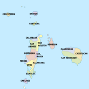 Political map of Romblon |
Subdivisions[]
Romblon is subdivided into 17 municipalities:
Demographics[]
Template:Philippine Census The majority of the inhabitants of the province are Visayan; some Negritos are found on the interior of Tablas and Carabao and Manguianes or May-as in Sibuyan mountains.
Although part of Southern Tagalog, there are three distinct native languages spoken by Romblon's inhabitants; they are Romblomanon or Ini, Bantoanon or Asi, and Inunhan or Onhan, which are classified as Visayan. Tagalog is widely understood, and English language stands as the medium of communication in business and trade.
The people of the province are mostly Christians: 75% of the population are Roman Catholic, while 25% belong to other Christian denominations such as the Philippine Independent Church, Iglesia ni Cristo, Seventh-day Adventist Church, Baptist churches, and Church of the Foursquare Gospel in the Philippines.[10]
Economy[]


Marble wares from Romblon
The province of Romblon has a mainly agricultural economy with copra farming, fishing, and rice farming as the chief agricultural activities. The fertile soil nurtures various agricultural crops like coconut, rice, corn, bananas, raffia palm, root crops, fruit trees, and many others. Its abundant fishing grounds supplies fish to various distribution centers in Batangas and Quezon province. The capital town of Romblon and the port town of Odiongan are the province's trade and commercial centers.
Mining is also a lucrative industry in the province due to its vast mineral resources. Aside from marble, the islands are rich in granite, nickel, silica, mercury, zinc, copper, silver, limestone, sulfide, ores, kaolin, clay, magnesium, and quartz. Gold panning sites have sprouted in some of the mountain stream areas in Magdiwang, Sibuyan Island.[8]
In recent years, tourism has also become a viable source of income for the province with its pristine beaches and crystal clear waters. Dive resorts such as in Concepcion and Cresta del Gallo have attracted local and foreign tourists alike. Carabao Island is also being eyed by its local government as the next Boracay, a popular vacation destination in Aklan province, which is only a few nautical miles from the island.[11]
Transportation[]
Situated at the center of the archipelago, Romblon links the supply areas of Luzon, Visayas, and Mindanao. Inter-island ferries from Manila, the Southern Luzon ports of Batangas City, Lucena City in Quezon province, Roxas, Oriental Mindoro, and Roxas City in Panay Island are the primary mode of transportation linking the province to the rest of the country. The province's main ports of entry are Odiongan, and the capital town of Romblon. Motorized wooden boats and launches also links the province to the towns of Buenavista, Marinduque and Pinamalayan, Oriental Mindoro.
Tugdan Airport in Alcantara, Tablas Island, is the only airport in the province and is less than an hour away from Metro Manila via flights once a week by South East Asian Airlines and three time a week by Zest Airways.
Media[]
FM Radio Stations
| Frequency | Name | Company | Website | Format | Call Sign | Power | Live Stream | Covered Location |
|---|---|---|---|---|---|---|---|---|
| 101.3 FM | Radyo Natin Odiongan | Manila Broadcasting Company | "RadyoNatin.com" | Variety Hits, Pop, Information, News | DZVG | 0.5 kW | "RN Odiongan" | Odiongan, Romblon |
| 104.5 FM | Hot FM Looc | Manila Broadcasting Company | "HotFM Official Website" | Variety Hits, Pop, Information, News | DWMM | 0.5 kW | Looc, Romblon | |
| 100.5 FM | Charm Radio Romblon | Polytechnic Foundation of Cotabato & Asia | Variety Hits, Pop, Information, News | DWGM-FM | 0.5 kW | Romblon, Romblon | ||
| 104.5 FM | Radyo Natin Romblon | Manila Broadcasting Company | "RadyoNatin.com" | Variety Hits, Pop, Information, News | DWMM-FM | 0.5 kW | Romblon, Romblon |
TV Stations
- GMA Network, Inc.: Channel 7
- People's Television Network: Channel 13
Cable providers and local cable stations
- Romblon Cable Corporation (Romblon, Romblon)
- Accutronics System Inc. (Odiongan, Romblon)
- San Agustin Cable Antenna Corp. (San Agustin, Romblon)
- Countryside Satellite Television System Inc. (Looc, Romblon)
- Gateway Cable TV Network (Calatrava, Romblon)
- San Andres CATV Service Coop. (San Andres, Romblon)
- Josefa J. Martinez CATV Services (Alcantara, Romblon)
- Magdiwang Cable Television (Magdiwang, Romblon)
- Sibuyan Cable TV (San Fernando, Romblon & Cajidiocan, Romblon)
Print Media
- Romblon Sun
- Romblon Text
Government[]
| Position | Jurisdiction | Official |
|---|---|---|
| Congressman | Lone District of Romblon | Hon. Eleandro Jesus F. Madrona |
| Governor | Province of Romblon | Hon. Eduardo C. Firmalo |
| Vice Governor | Province of Romblon | Hon. Jose R. Riano |
Provincial legislature[]
| 1st District | 2nd District |
|---|---|
| Hon. Samuel R. Romero | Hon. Felix F |
| Hon. Abner R. Perez | Hon. Jim G. Fondevilla |
| Hon. Anthony Rugas | Hon. Venizar R. Maravilla |
| Hon. Nelson R.Lim | Hon. Fred R. Dorado |
Ex officio members[]
| Position | Official |
|---|---|
| President, Provincial Councilors' League | Hon. Patria S. Perez |
| President, Association of Barangay Captains | Hon. Gerry R. Tansiongco |
| President, Provincial Federation of SK | Hon. Val Joseph F. Maulion |
List of former Romblon provincial executives[]
References[]
- ^ "List of Provinces". PSGC Interactive. Makati City, Philippines: National Statistical Coordination Board. http://www.nscb.gov.ph/activestats/psgc/listprov.asp. Retrieved 31 January 2013.
- ^ a b "Population and Annual Growth Rates for The Philippines and Its Regions, Provinces, and Highly Urbanized Cities". 2010 Census and Housing Population. National Statistics Office. http://www.census.gov.ph/sites/default/files/attachments/hsd/pressrelease/Population%20and%20Annual%20Growth%20Rates%20for%20The%20Philippines%20and%20Its%20Regions%2C%20Provinces%2C%20and%20Highly%20Urbanized%20Cities%20Based%20on%201990%2C%202000%2C%20and%202010%20Censuses.pdf. Retrieved 31 January 2013.
- ^ Brief History of Banton The Official Website of Banton, Romblon. Retrieved on 2013-03-30
- ^ a b c "History of Carmen including Historical and Cultural Background of North-eastern Barangays of the Municipality of San Agustin, Romblon." Romblon Municipal Library
- ^ Brief History of Romblon Romblon Travel Guide. Retrieved on 30 March 2013
- ^ a b Romblon History Romblon Tourism.com Retrieved on 30 March 2013.
- ^ Mt. Guiting-Guiting Pinoy Mountaineer. Retrieved on 30 March 2013
- ^ a b Romblon Facts and Figures Romblon Travel Guide. Retrieved on 30 March 2013
- ^ About Romblon Romblon Tourism.com Retrieved on 30 March 2013.
- ^ Division Profile Romblon DepED Region IV - MIMAROPA. Retrieved on 30 March 2013.
- ^ Carabao Island, Up Close Senyor Lakwatsero. Retrieved on 31 March 2013.
External links[]
- Official website of the Provincial Government of Romblon
- Philippine Standard Geographic Code
- Philippine Census Information
- Local Governance Performance Management System
- Travel Guide: Romblon
- Brief History of Romblon

|
Marinduque Sibuyan Sea |
| ||
| Oriental Mindoro / Tablas Strait | Sibuyan Sea / Masbate | |||
 Romblon | ||||
| Sibuyan Sea Aklan |
Template:Romblon Template:MIMAROPA Template:Luzon lateral Template:Philippines topics