| Main | Births etc |
|---|
Rockville is a census-designated place and a village of the town of Vernon in Tolland County, Connecticut, United States. The population was 7,474 at the 2010 census. Incorporated as a city in 1889, it has been consolidated with the town of Vernon since 1965.
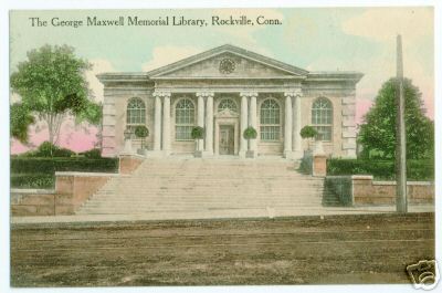
George Maxwell Memorial Library, postcard mailed in 1911

George Maxwell Memorial Library, photograph from 2006
Geography[]
According to the United States Census Bureau, the CDP has a total area of 1.8 square miles (4.7 km2), of which, 1.7 square miles (4.4 km2) of it is land and 0.04 square miles (0.10 km2) of it (1.70%) is water.
History[]
Before the mills[]
In 1726, Samuel Grant traded his farm in Bolton for 500 acres (2.0 km2) in the northern part of Bolton. This included the area which is now known as "Rockville" and for about the next century it was a nameless village. A prominent feature of the area is the Shenipsit Lake, or "The Snip" as it is currently affectionately called by the residents. The Snip feeds the Hockanum River which cascades 254 feet over 1.5 miles (2.4 km). The river was used by the farmers for a grist mill, a saw mill, an oil mill and even a distillery starting around 1740.
The Rock Mill[]

Hockanum Manufacturing Co., ca. 1909
In 1821, Colonel Francis McLean built the first textile mill in what is now Rockville in partnership with George and Allyn Kellogg and Ralph Talcott, next to a spot known as "the Rock" with capital of $16,000. Francis McLean had partnered previously with some others in the Warburton Mill in Talcottville. "The Rock" was a natural dam of solid stone that made a high falls on the Hockanum River. In what is now the center of Rockville, he dammed up the Hockanum River and built a water powered mill known as the "Rock Mill", which was possibly also known as the McLean Woolen Factory. By 1823 his mill was in full operation. The new mill was 80 by 30 feet, and its product was blue and blue-mix satinet. In 1826 power looms were introduced.
The mill attracted people to this area and by 1836 the population grew to 440 consisting of 61 families including 89 children under the age of 10.
Rockville gets its name[]
Mail service was brought once a day by stagecoach from Vernon Center, which was the post office and place for voting for the town. In 1837, according to old records, "an amateurish notice was posted on the Rock Mill announcing a public meeting in the lecture room of the village to decide in a democratic way the most suitable name for the vicinity". In order to have their own post office the town needed a permanent name.
- The following were some of the recommendations for naming the town.
- Frankfort - in honor of Francis Mclean builder of the "Rock Mill"
- Vernon Falls
- Grantville - in honor of Samuel Grant the first settler
- Hillborough - because the terrain is so hilly
Simon Chapman, who ran a boarding house for mill workers, submitted the name "Rockville" as common expression understood by the surrounding areas was "Going to the Rock". Thus, Rockvillle became the official name. It was not until 1842, however, that Rockville actually acquired its own post office.
Rockville Historic District[]
|
Rockville Historic District | |
|

| |
| Location: | Roughly bounded by Snipsic St., Davis Ave., West and South Sts., Rockville, Connecticut |
|---|---|
| Coordinates: | Coordinates: |
| Area: | 550 acres (223 ha) |
| Architect: | Platt,Charles A. et al |
| Architectural style: | Greek Revival, Late Victorian, Classical Revival |
| Governing body: | Local |
| NRHP Reference#: | 84001173[1] |
| Added to NRHP: | September 13, 1984 |
Most of Rockville has been designated as part of the Rockville Historic District. The district is roughly bounded by Shenipsit Street, Davis Avenue, West Street and South Street was added in 1984 to the National Register of Historical Places. The district includes 842 buildings and one other structure. It includes examples of Greek Revival, Late Victorian, and Classical Revival architecture. The historic district includes 842 buildings and one other structure over 550 acres (2.23 km2).[1]
Buildings of architectural or historic interest in Rockville include:


The Tower on Fox Hill
Downtown Mill area[]
- Belding Silk Mills
- Samuel Fitch's Mill
- Dart Stone Mill
- St. Bernard Church
- Memorial Building housing currently the New England Civil War Museum and the Grand Army of the Republic Hall as well as the town offices for Vernon.
Talcott Park neighborhood[]
Elm Street, Park Street, and one block of Prospect Street surround a small town park named Talcott Park. The houses represent a variety of Victorian architectural styles ranging from early nineteenth century Greek Revival through the Gothic Revival and Italianate styles down to the Victorian eclecticism of the 1880s and 1890s. The mill owners usually built their houses in the downtown area.
- Old Rockville High School and East School
- James I. Regan House
- Phineas Talcott Homestead
- Arthur T. Bissell House
- George Sykes House
- Charles Phelps House
- (#10 and #12) Ellington Ave.
- Francis T. Maxwell House also known as Maxwell Court
- Caleb Tefft House
- David Sykes House
- Elbridge K Leonard House
Downtown and Central Park[]
The surviving buildings grouped around Central Park are a continuing reminder of the wealth brought by the woolen industry and the town's aspirations to be a leading city in the state during the 19th century.
Downtown East[]
- Rockville National Bank
- Union Congregational Church
- Citizen's Block
- Rockville Methodist Episcopal Church
- Memorial Building
Downtown West[]
- Fitch Block
- William and Alice Maxwell House
- George Maxwell Memorial Library
On or about November 1, 2007, the light fixtures that sat beside the library steps were stolen. Both fixtures were made of copper shaped into globes. They weighed over one hundred pounds each and were installed as part of the original construction.
- Kellogg House
The Kellogg House had been used by the State Department of Children and Families to house troubled youth under a contract with Community Solutions, Inc. This arrangement ended on May 2, 2006 after a long history of documented mismanagement by both agencies. The facility is now used for adult transitional housing.
Village Street[]
- Turn Halle
- Brautigum House
- Erhardt Linck's Hall
- 70 Village Street]
- William Randall House and Store
- Otto Schrier House
- Chauncey Winchell Jr House
West Main Street[]
- George Sykes House (first)
- Hockanum Mill
- Saxony Mill
- Chauncey Winchell Homestead
- Alonzo Bailey House
- Springville Mill and Offices
- Florence Mill
- Henry Huhnken's Saloon
- New England Yard
Other areas[]
- Castle Sunset
- The Tower on Fox Hill
- Baptist Church, since destroyed to make room for a bigger parking lot for Rockville General Hospital.
- Maple Street School
Demographics[]
As of the census[2] of 2010, there were 7,474 people, 3,292 households, and 1,681 families residing in the CDP. The population density was 4,419.9 people per square mile (1,720.3/km2). There were 3,682 housing units at an average density of 1,947.9 per square mile (853.4/km2). The racial makeup of the CDP was 76.0% White, 11.7% African American, 0.4% Native American, 3.3% Asian, 0.1% Pacific Islander, 4.5% from other races, and 4.1% from two or more races. Hispanic or Latino of any race were 12.2% of the population.
There were 3,292 households out of which 26.8% had children under the age of 18 living with them, 25.6% were married couples living together, 19.6% had a female householder with no husband present, and 48.9% were non-families. 39.2% of all households were made up of individuals and 14.0% had someone living alone who was 65 years of age or older. The average household size was 2.24 and the average family size was 2.98.
In the CDP the population was spread out with 26.5% under the age of 20, 17.8% from 20 to 29, 19.8% from 30 to 44, 23.9% from 45 to 64, and 12.1% who were 65 years of age or older. The median age was 33.7 years. For every 100 females there were 90.9 males. For every 100 females age 18 and over, there were 87.7 males.
The median income for a household in the CDP was $40,451, and the median income for a family was $40,714. Males working year-round and full-time had a median income of $48,159 versus $37,865 for females. The per capita income for the CDP was $23,079. About 24.5% of families and 22.6% of the population were below the poverty line, including 37.1% of those under age 18 and 16.0% of those age 65 or over.
Notable people from Rockville[]
- Stephen Farrell (1863–1933), world champion sprinter and track coach
- Morgan Lewis (1906–1968), songwriter and Broadway theatre composer
- Dwight Loomis (1821–1903), U.S. Representative
- Kenneth North (1930-2010), U.S. Air Force brigadier general
- Gene Pitney (1940–2006), internationally known singer/songwriter, member of Rock & Roll Hall of Fame, born in Hartford, raised in Rockville
- Charles Ethan Porter (1847-1923), artist
- Bill Romanowski (1966–present), NFL linebacker, born in Vernon, graduated from Rockville High School in 1984
References[]
- ^ a b "National Register Information System". National Register of Historic Places. National Park Service. 2009-03-13. http://nrhp.focus.nps.gov/natreg/docs/All_Data.html.
- ^ "American FactFinder". United States Census Bureau. http://factfinder2.census.gov. Retrieved 2011-05-14.
External links[]
- Official Web Page for the town of Vernon
- Community Web Page
- Another Community Web Page
- Vernon Historical Society
External links[]
- A Walk Through Rockville's Past... The Loom City Revisited - Walking tours through historic Rockville
- Map of Rockville CDP and Rockville Historic District
| ||||||||||
| ||||||||||

| ||||||||||||||||||||
| This page uses content from the English language Wikipedia. The original content was at Rockville, Connecticut. The list of authors can be seen in the page history. As with this Familypedia wiki, the content of Wikipedia is available under the Creative Commons License. |