| Main | Births etc |
|---|
| ||||||||||||||
| Rensselaer County | |
| County | |
Seal of Rensselaer County
| |
| Name origin: For the family of Kiliaen van Rensselaer, the original Dutch owners of Rensselaerswyck | |
| Country | United States |
|---|---|
| State | New York |
| Region | Upstate New York |
| District | Capital District |
| Towns | 14
|
| Cities | Troy, Rensselaer |
| Villages | 6
|
| Capital | City of Troy |
| - elevation | 30 ft (9 m) |
| - coordinates | |
| Highest point | Berlin Mountain |
| - location | Town of Berlin, on border with Massachusetts |
| - elevation | 2,818 ft (859 m) |
| - coordinates | |
| Lowest point | Hudson River at sea level |
| - elevation | 0 ft (0 m) |
| Area | 665 sq mi (1,722 km²) |
| - land | 654 sq mi (1,694 km²) |
| - water | 11 sq mi (28 km²) |
| Population | 161,130 (2020) |
| Density | 243 / sq mi (94 / km²) |
| Incorporated | 1791 |
| County executive | Kathleen M. Jimino |
| Timezone | Eastern Standard Time (UTC-5) |
| - summer (DST) | Eastern Daylight Time (UTC-4) |
| Area code | 518 |
 Map of New York highlighting Rensselaer County
| |
 Map of Rensselaer County showing the cities, towns, and villages
| |
| Wikimedia Commons: Rensselaer County, New York | |
| Website: www.rensco.com | |
Rensselaer County is a county in the U.S. state of New York. As of the 2020 census, the population was 161,130. Its name is in honor of the family of Kiliaen van Rensselaer, the original Dutch owner of the land in the area. Its county seat is Troy. It is part of the Albany-Schenectady-Troy Metropolitan Statistical Area.
History[]
- For the history of Rensselaer County prior to 1791, see Albany County, New York
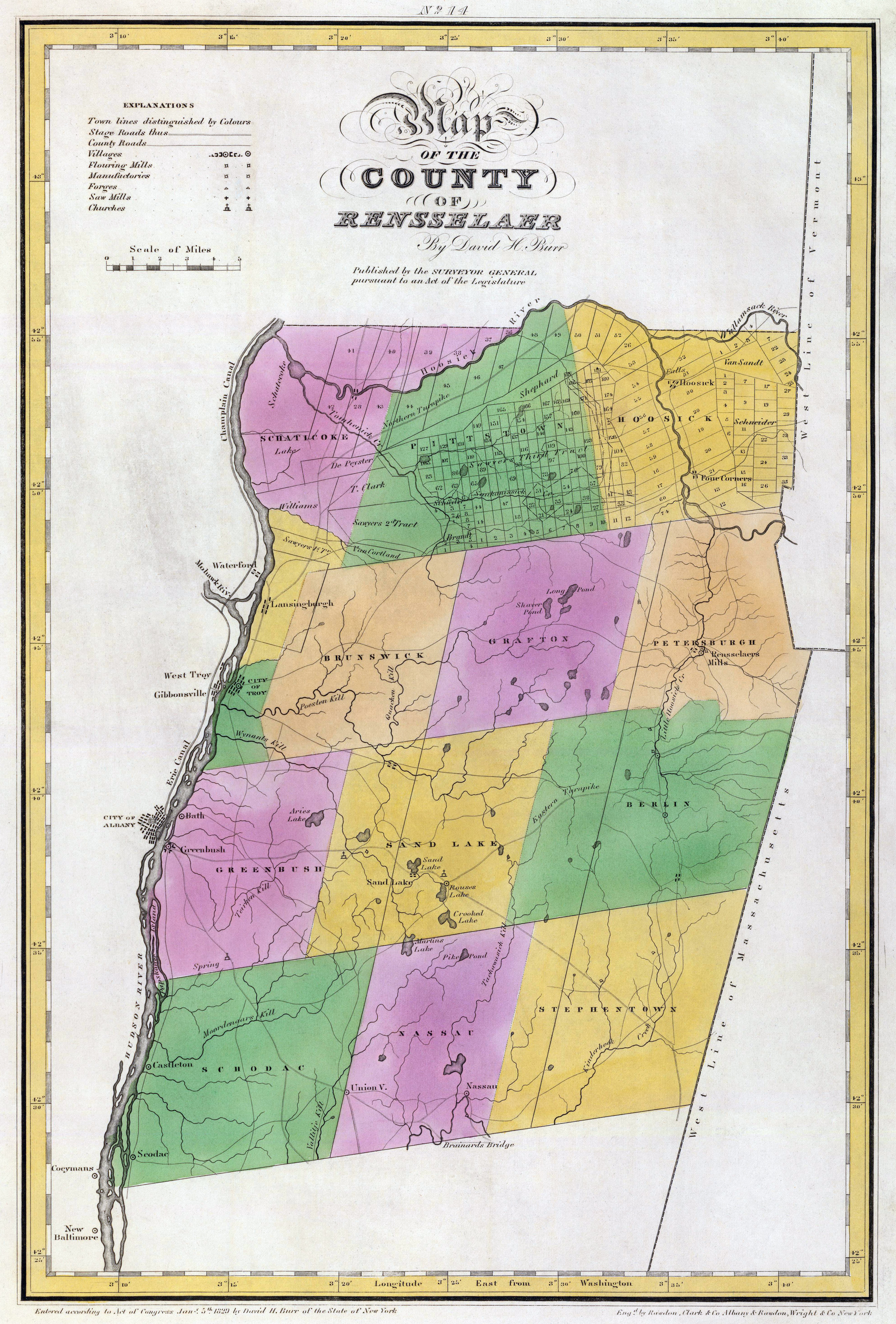
Map of Rensselaer County in 1829
The area that is now Rensselaer County was originally inhabited by the Mohican Indian tribe until it was bought by the Dutch jeweler and merchant Kiliaen van Rensselaer in 1630 and incorporated in his patroonship Rensselaerswyck (which, in turn, was part of the Dutch colony New Netherland). The land passed into English hands in 1664 until the Dutch regained control for a year in 1673, but the English took it back in 1674. Until 1776, the year of American independence, it was under English or British control.[1] However, the county didn't actually exist as a legal entity until 1791 when it was created from land that was originally part of Albany County.
In 1807, in a county re-organization, the rural sections of Troy were set off as towns, and the city itself was incorporated. The two towns created were Brunswick and Grafton, both named after British dukes, (the Duke of Brunswick and Duke of Grafton). A third town, Philipstown, was set off in 1806, but renamed in 1808 to Nassau after the Duke of Nassau.
Geography[]


A farm in Brunswick
Rensselaer County is in the eastern part of New York State. The eastern boundary of Rensselaer County runs along the New York-Vermont and New York-Massachusetts borders.
According to the U.S. Census Bureau, the county has a total area of 665 square miles (1,723 km²), of which 654 square miles (1,694 km²) is land and 11 square miles (30 km²) (1.72%) is water.
The terrain runs from level and flat near the Hudson and then rises into the Rensselaer Plateau around Poestenkill and Sand Lake, then to the Taconic Mountains along the Massachusetts state line.
The highest point is Berlin Mountain, 2,818 feet (859 m) above sea level, in the town of Berlin. The lowest point is sea level at the Hudson.
The Hoosic River, a tributary of the Hudson River, is in the north part of the county.
Adjacent counties[]
- Washington County, New York - north
- Bennington County, Vermont - northeast
- Berkshire County, Massachusetts - southeast
- Columbia County, New York - south
- Greene County, New York - southwest
- Albany County, New York - west
- Saratoga County, New York - northwest
Demographics[]
| Historical populations | |||
|---|---|---|---|
| Census | Pop. | %± | |
| 1800 | 30,442 | ||
| 1810 | 36,309 | 19.3% | |
| 1820 | 40,153 | 10.6% | |
| 1830 | 49,424 | 23.1% | |
| 1840 | 60,259 | 21.9% | |
| 1850 | 73,363 | 21.7% | |
| 1860 | 86,328 | 17.7% | |
| 1870 | 99,549 | 15.3% | |
| 1880 | 115,328 | 15.9% | |
| 1890 | 124,511 | 8.0% | |
| 1900 | 121,697 | −2.3% | |
| 1910 | 122,276 | 0.5% | |
| 1920 | 113,129 | −7.5% | |
| 1930 | 119,781 | 5.9% | |
| 1940 | 121,834 | 1.7% | |
| 1950 | 132,607 | 8.8% | |
| 1960 | 142,585 | 7.5% | |
| 1970 | 152,510 | 7.0% | |
| 1980 | 151,966 | −0.4% | |
| 1990 | 154,429 | 1.6% | |
| 2000 | 152,538 | −1.2% | |
| 2010 | 159,429 | 4.5% | |
| [2][3][4] | |||
As of the census[5] of 2000, there were 152,538 people, 59,894 households, and 39,050 families residing in the county. The population density was 233 people per square mile (90/km²). There were 66,120 housing units at an average density of 101 per square mile (39/km²). The racial makeup of the county was 91.13% White, 4.69% Black or African American, 0.23% Native American, 1.71% Asian, 0.02% Pacific Islander, 0.89% from other races, and 1.34% from two or more races. 2.11% of the population were Hispanic or Latino of any race. 22.3% were of Irish, 14.7% Italian, 12.8% German, 7.5% English, 6.2% French and 5.3% American ancestry according to Census 2000. 93.4% spoke English and 2.0% Spanish as their first language.
There were 59,894 households out of which 31.30% had children under the age of 18 living with them, 48.80% were married couples living together, 12.00% had a female householder with no husband present, and 34.80% were non-families. 27.90% of all households were made up of individuals and 10.30% had someone living alone who was 65 years of age or older. The average household size was 2.46 and the average family size was 3.02.
In the county the population was spread out with 24.20% under the age of 18, 10.10% from 18 to 24, 29.10% from 25 to 44, 23.00% from 45 to 64, and 13.60% who were 65 years of age or older. The median age was 37 years. For every 100 females there were 95.90 males. For every 100 females age 18 and over, there were 93.70 males.
The median income for a household in the county was $42,905, and the median income for a family was $52,864. Males had a median income of $36,666 versus $28,153 for females. The per capita income for the county was $21,095. About 6.70% of families and 9.50% of the population were below the poverty line, including 11.90% of those under age 18 and 6.60% of those age 65 or over.
Government and politics[]

Rensselaer County Office building, which houses county offices, including that of the County Executive


Rensselaer County Courthouse, located on the corner of Congress and 2nd Streets in Troy
| Year | Republican | Democratic | Third party | |||
|---|---|---|---|---|---|---|
| No. | % | No. | % | No. | % | |
| 2020 | 36,500 | 45.96% | 40,969 | 51.59% | 1,940 | 2.44% |
| 2016 | 33,726 | 47.13% | 32,717 | 45.72% | 5,119 | 7.15% |
| 2012 | 29,113 | 42.77% | 37,408 | 54.96% | 1,540 | 2.26% |
| 2008 | 32,840 | 44.39% | 39,753 | 53.73% | 1,393 | 1.88% |
| 2004 | 34,734 | 47.90% | 36,075 | 49.75% | 1,705 | 2.35% |
| 2000 | 29,562 | 43.20% | 34,808 | 50.86% | 4,066 | 5.94% |
| 1996 | 23,482 | 34.72% | 34,273 | 50.68% | 9,870 | 14.60% |
| 1992 | 28,937 | 38.80% | 29,793 | 39.95% | 15,850 | 21.25% |
| 1988 | 35,412 | 51.18% | 33,066 | 47.79% | 719 | 1.04% |
| 1984 | 43,892 | 61.94% | 26,755 | 37.76% | 217 | 0.31% |
| 1980 | 32,005 | 45.89% | 29,880 | 42.84% | 7,862 | 11.27% |
| 1976 | 40,229 | 57.76% | 28,979 | 41.60% | 445 | 0.64% |
| 1972 | 48,864 | 66.87% | 24,019 | 32.87% | 188 | 0.26% |
| 1968 | 34,674 | 50.49% | 30,232 | 44.02% | 3,775 | 5.50% |
| 1964 | 20,814 | 28.88% | 51,170 | 71.01% | 76 | 0.11% |
| 1960 | 40,124 | 52.59% | 36,109 | 47.33% | 61 | 0.08% |
| 1956 | 55,186 | 72.90% | 20,516 | 27.10% | 0 | 0.00% |
| 1952 | 51,453 | 66.57% | 25,734 | 33.29% | 109 | 0.14% |
| 1948 | 40,375 | 56.71% | 28,468 | 39.98% | 2,354 | 3.31% |
| 1944 | 37,819 | 55.51% | 30,173 | 44.29% | 139 | 0.20% |
| 1940 | 39,648 | 54.97% | 32,387 | 44.90% | 97 | 0.13% |
| 1936 | 34,772 | 50.67% | 31,754 | 46.27% | 2,095 | 3.05% |
| 1932 | 30,606 | 47.66% | 32,783 | 51.05% | 828 | 1.29% |
| 1928 | 32,370 | 48.90% | 33,094 | 50.00% | 727 | 1.10% |
| 1924 | 30,549 | 55.88% | 19,783 | 36.18% | 4,341 | 7.94% |
| 1920 | 28,810 | 56.08% | 20,224 | 39.37% | 2,337 | 4.55% |
| 1916 | 14,968 | 51.21% | 13,822 | 47.29% | 440 | 1.51% |
| 1912 | 10,853 | 39.48% | 11,684 | 42.50% | 4,954 | 18.02% |
| 1908 | 17,196 | 54.92% | 13,162 | 42.04% | 953 | 3.04% |
| 1904 | 17,631 | 56.72% | 12,529 | 40.31% | 925 | 2.98% |
| 1900 | 17,228 | 55.03% | 13,464 | 43.01% | 614 | 1.96% |
| 1896 | 17,221 | 55.71% | 13,119 | 42.44% | 574 | 1.86% |
| 1892 | 13,666 | 45.64% | 14,879 | 49.69% | 1,397 | 4.67% |
| 1888 | 15,718 | 49.62% | 15,410 | 48.65% | 549 | 1.73% |
| 1884 | 13,759 | 48.66% | 13,414 | 47.44% | 1,102 | 3.90% |
From 1884 through the 1988 campaign, voters in
Rensselaer County chiefly supported the Republican candidate, though the county has since swung to a majority voting for the Democrat, with Donald Trump in 2016 the sole Republican to carry the county since.
Beginning in 1791, Rensselaer County was governed by a Board of Supervisors, which acted as the Legislature, with the chairman of the board serving as a de facto Executive. The Board of Supervisors form of government was terminated as a result of a class action lawsuit brought by Troy attorney Marvin I. Honig on behalf of his wife, Nedda, during March 1968. Mr. Honig brought this lawsuit to declare that the Board of Supervisors, as constituted, violated the "one man, one vote" principal declared by the United States Supreme Court. Mr. Honig's motive in bringing the lawsuit was to punish the Rensselaer County Republican Party chairman and certain members of the Board of Supervisors for defaulting on an agreement with him. The NY Supreme Court ruled in Honig's favor, and ordered the creation of a legislative body. Several plans were offered, but a plan proposed by Honig was adopted by the Court, and its decision was affirmed by the Appellate Division and Court of Appeals. The first "Honig Plan" was drawn to favor the Democratic party, which had not had control of the county government in decades. That plan, which controlled the 1969 election, resulted in the Democrats winning control of the new Rensselaer County Legislature. Thereafter, following a change of leadership in the Republican party, Honig brought a new plan, drawn to favor Republican candidates, to the court, which adopted his revised plan. The second "Honig Plan" was affirmed by the Appellate Division and the Court of Appeals. The Republican candidates won back the County Legislature in the 1971 election, and Honig became the Renssselaer County Attorney, a position he held for well over a decade. A full explanation of the creation of the Rensselaer County Legislature can be found at http://nassau-stories.blogspot.com/2006/04/reapportionment.html. See also: The Troy Record, July 8, 1971, page 1.
In 1970, the Rensselaer County Legislature was created, which elected Edward J. "Ned" Quinn as chairman. The Chairman served as the equivalent to an executive until the office of County Executive was created in 1972. Since its creation, Democrats have never won the office, although they controlled the Legislature until 1994. One notable candidate for Executive was Edward Pattison who was later elected to Congress, and whose son Mark served two terms as Mayor of Troy. The current county executive is Steve McLaughlin (R).
Legislative authority is vested in the County Legislature, which consists of 19 members representing 17 different communities, separated into six districts. The current composition of the Legislature is as follows (12 Republicans, six Democrats, one Conservative that caucuses with the Republicans, and one Conservative who caucuses with the Democrats):
District 1 – Troy:
- Template:Party shading/Coalition/block Bobby Burns (C)
- Cynthia B. Doran (D), Deputy Minority Leader
- Mark J. Fleming (D)
- Peter D. Grimm (D), Minority Leader
- Erin Sullivan-Teta (D)
- Carole C. Weaver (D)
District 2 – North Greenbush, East Greenbush, and Poestenkill:
- Robert W. Bayly (R)
- Leon B. Fiacco (R)
- Thomas Grant (R)
- Template:Party shading/Coalition/block Kelly Hoffman (C), Vice Chairperson
District 3 – Brunswick, Schaghticoke, and Pittstown:
- Dan Casale(R)
- Kenneth Herrington (R), Majority Leader
- Todd J. Tesman (R)
District 4 – Schodack, Sand Lake, and Nassau:
- Scott Bendett (R)
- Robert R. Loveridge (R), Vice Chairperson for Finance
- Chuck Peter (R)
District 5 – Hoosick Falls, Hoosick, Grafton, Berlin, Stephentown, & Petersburgh:
- Bruce Patire (R)
- Jeffrey Wysocki (R)
District 6 – Rensselaer:
- Michael Stammel (R), Chairman
| Name | Party | Term |
|---|---|---|
| William J. Murphy | Republican | January 1, 1974 – December 31, 1985 |
| John L. Buono | Republican | January 1, 1986 – May, 1995 |
| Henry F. Zwack | Republican | May, 1995 – May 13, 2001 |
| Kathleen M. Jimino | Republican | May, 2001 – December 31, 2017 |
| Steven F. McLaughlin | Republican | January 1, 2018 – present |
Cities, towns, villages, and other locations[]
|
|
|
School districts[]
The county is serviced by 16 school districts. Some are completely contained in the county while some cross county lines into other counties. No school districts cross either the Vermont or Massachusetts state borders. Below is a table that shows the districts within the county, which BOCES they belong to, and which other counties they may serve.[7]
| District | BOCES[8][9] | Other Counties District Serves |
|---|---|---|
| Averill Park Central School District | Questar III | None |
| Berlin Central School District | Questar III | None |
| Brunswick (Brittonkill) Central School District | Questar III | None |
| Cambridge Central School District | WSWHE BOCES | Washington County |
| East Greenbush Central School District | Questar III | Columbia County |
| Hoosic Valley Central School District | Questar III | Washington County |
| Hoosick Falls Central School District | N/A | Washington County |
| Ichabod Crane Central School District | Questar III | Columbia County |
| Lansingburgh Central School District | Questar III | None |
| Mechanicville City School District | WSWHE BOCES | Saratoga County |
| New Lebanon Central School District | Questar III | Columbia County |
| North Greenbush Common School District | Questar III | None |
| Rensselaer City School District | Questar III | None |
| Schodack Central School District | Questar III | Columbia County |
| Troy City School District | Questar III | None |
| Wynantskill Union Free School District | Questar III | None |
See also[]
- List of counties in New York
- List of county routes in Rensselaer County, New York
- National Register of Historic Places listings in Rensselaer County, New York
References[]
- ^ The Kingdom of England existed until the Acts of Union 1707, when Scotland and England (including Wales) came together to form the Kingdom of Great Britain.
- ^ http://www.census.gov/population/www/censusdata/cencounts/files/ny190090.txt
- ^ http://factfinder2.census.gov
- ^ http://mapserver.lib.virginia.edu/
- ^ "American FactFinder". United States Census Bureau. http://factfinder.census.gov. Retrieved 2008-01-31.
- ^ Leip, David. "Dave Leip's Atlas of U.S. Presidential Elections". http://uselectionatlas.org/RESULTS.
- ^ Rensselaer County School Districts. Capital District Regional Planning Commission. Retrieved 14 October 2008.
- ^ Questar III Component School Districts. Questar III. Retrieved 14 October 2008.
- ^ Washington-Saratoga-Warren-Hamilton-Essex BOCES Component Districts. Washington-Saratoga-Warren-Hamilton-Essex BOCES. Retrieved 14 October 2008.
Further reading[]
- Anderson, George Baker (1897). Landmarks of Rensselaer County New York. Syracuse, New York: D. Mason and Company. OCLC 1728151. http://www.archive.org/stream/landmarksofrenss00ande#page/n5/mode/2up.
- Hayner, Rutherford (1925). Troy and Rensselaer County New York: A History. New York: Lewis Historical Publishing Company, Inc. OCLC 22524006.
- Sylvester, Nathaniel Bartlett (1880). History of Rensselaer Co., New York with Illustrations and Biographical Sketches of its Prominent Men and Pioneers. Philadelphia: Everts & Peck. OCLC 3496287.
- Weise, Arthur James (1880). History of the Seventeen Towns of Rensselaer County from the Colonization of the Manor of Rensselaerwyck to the Present Time. Troy, New York: J. M. Francis & Tucker. OCLC 6637788. http://www.archive.org/stream/cu31924064123015#page/n5/mode/2up.
External links[]

|
Saratoga County | Washington County | Bennington County, Vermont |
|
| Albany County | ||||
 Rensselaer County, New York | ||||
| Greene County | Columbia County | Berkshire County, Massachusetts |
| |||||||||||||||||||||||

| ||||||||||||||||||||||||||||||||||||||||||||||

| ||||||||||||||||||||

| This page uses content from the English language Wikipedia. The original content was at Rensselaer County, New York. The list of authors can be seen in the page history. As with this Familypedia wiki, the content of Wikipedia is available under the Creative Commons License. |