Regionalisations of Western Australia are systems by which Western Australia is divided into distinct geographic regions. The most commonly known regionalisation is the governmental division of the state into regions for economic development purposes.
Others regionalisations include those made for purposes of land management, such as agriculture or conservation; information gathering, such as statistical or meteorological.
Although most regionalisations were defined for specific purposes and give specific boundaries, many regions will have similar names and extents across different regionalisations. As a result, the names and boundaries of regions can vary in popular usage. There are nine regions.
Familypedia use[]
For locations of genealogical events, Familypedia could use the nine RDCA regions (as defined in the following section) plus Perth as the primary division of the State, corresponding to counties in the United States or the United Kingdom. That would have the advantage of probably stable boundaries. However, as Local Government Areas cover the whole State and are used as the "county" equivalent in other states, the latter should be used in WA as well.
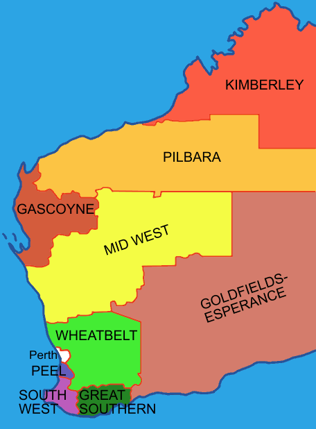
The Regional Development Commissions Act regionalisation[]
Map of the regions
The most widely known regionalisation of Western Australia is the one defined by the State Government for purposes of economic development administration. Together, these constitute the whole of mainland Western Australia, with the exception of the Perth metropolitan area which is not contained in a region.
These regions were established by the Regional Development Commissions Act 1993, which defined their extents and established Regional Development Commissions to promote their economic development. In defining the regions, an attempt was made to capture distinct socio-economic communities. For example, the Goldfields-Esperance region of Western Australia has an economy based heavily on mining, whereas the Wheatbelt region is economically dependent on agriculture.
The regions as determined are:
- Gascoyne
- Goldfields-Esperance
- Great Southern
- Kimberley
- Mid West
- Peel
- Pilbara
- South West
- Wheatbelt
For the earlier land administrative divisions of Western Australia - see: - Lands_administrative_divisions_of_Western_Australia#Land_divisions
Weather bureau areas[]
The same terms used by the RDCA are also used by BOM [1] - but do not directly coincide with the boundaries of the Regional Development defined boundaries above.
The BOM designates the forecast areas with finer detail on weather reports into points of the compass - as with the Interior area - southern interior, and western interior.
Numbers 7 to 13 are usually known as those forecast areas in the Southwest Land Division, and coastal zones for sea forecasts are dealt with in Coastal regions of Western Australia
| BOM Map number | BOM name | RDCA name | BOM overlap areas | RDCA overlap areas | notes | fit |
|---|---|---|---|---|---|---|
| 01 | Kimberley | Kimberley | South East Kimberley in BOM 'NE Interior' | close fit | ||
| 02 | Pilbara | Pilbara | BOM North Interior in RDCA 'East Pilbara' | |||
| 03 | Gascoyne | Gascoyne | BOM South and East Gascoyne in RDCA 'Mid West' | |||
| 04 | Goldfields | Goldfields-Esperance | ||||
| 05 | Eucla | Goldfields-Esperance | ||||
| 06 | Interior | Goldfields-Esperance, Mid West, Pilbara | ||||
| 07 | Central West | Mid West | ||||
| 08 | Lower West | Perth, Peel | ||||
| 09 | Southwest | South West | ||||
| 10 | South Coastal | Great Southern | ||||
| 11 | Southeast Coastal | Goldfields-Esperance | ||||
| 12 | Great Southern | Great Southern | ||||
| 13 | Central Wheat Belt | Wheatbelt | ||||
Political regionalisations[]
Under Australia's three-tiered system of government, Western Australia is divided into:
Federal electoral divisions[]
- (for election to the Australian House of Representatives)
State[]
- electoral districts (for election to the Western Australian Legislative Assembly)
- electoral regions (for election to the Western Australian Legislative Council)
Local[]
Departmental regionalisations[]
Many government departments maintain systems of regional and district breakdowns of the state for their own internal purposes - a good example would be the Educations Departments school districts
- Agriculture Department Western Australia: - see the regional focus page [2]
- Northern Agricultural Region
- Rangelands Region
- Southern Agricultural Region
- Central Agricultural Region
- South West Agricultural
- Main Roads Western Australia regionalisations: - see the Road alert page [3]
- Department of Water Western Australia - the region page [4]
- Kimberley
- Pilbara
- Mid West Gascoyne
- Goldfields
- Swan-Avon
- Kwinana Peel
- South West
- South Coast
Natural regionalisations[]
There are a number of regionalisations that purport or attempt to provide a regionalisation based on natural features. The best known of these are the IBRA regions, the World Wildlife Fund's ecoregions, and the "natural regions" of John Stanley Beard, all of which are based on biogeography. Other natural regionalisations included the drainage basins and catchments of river systems, and highly specialised regionalisations dealing with such matters as geology and soil systems.
Land management regionalisations[]
Regionalisations of Western Australia used for land management and conservation purposes include the natural regionalisations such as IBRA, and also some less natural regionalisations such as Landcare Districts and the Department of Agriculture's "Land-use Zones". However the Department of Agriculture publications - Technical Bulletins [5] - usually titled An inventory and condition report/survey... of a particular region are very specifically focused upon land systems that are based on natural features.
Fisheries management regionalisations[]
The Department of Fisheries tends to separate the state into four main regions for the purpose of regulating recreational fishing: - Pilbara Kimberley, Gascoyne, WestCoast and South Coast. See - Coastal regions of Western Australia for more detail.
Land tenure regionalisations[]
Much of Western Australia is divided into approximately 90 land districts for the purposes of identifying land lots.
Mining[]
- See article: Mining fields in Western Australia
Under the Mining Act - the hierarchy of Administrative Divisions for mining has in the past been divided into -
- Inspector of Mines - office and Inspectorate
- Mining Registrars - Administrative boundary and office
- State Mining Engineers Inspectorate
- Gold Field District
- Gold or Mineral Field boundary
Since the creation of the Department of Industry and Resources some rationalisation of administration has occurred, however the mineral fields and boundaries remain the same as when established.[6]
Wine regions[]
Australia’s biggest State extends the western third of the continent, although the winemaking regions are almost entirely situated in the south-western tip of the State. It has nine regions, and five nominated subregions for wine under the Geographical indications legislation as determined by the Australian Wine and Brandy Corporation.[7][8][9]
These regions include:
- Greater Perth
- Perth Hills
- Peel
- Swan District
- South Western Australia
- Blackwood Valley
- Geographe
- Great Southern
- Albany
- Denmark
- Frankland River
- Mount Barker
- Porongurup
- Manjimup
- Margaret River
- Pemberton[10]
Coastal regions[]
- Main article: Coastal regions of Western Australia
Western Australia has the longest coastline of any state in Australia, at 10,194 km [11] The regions can be determined by the underlying geology, and in the case of the Bureau of Meteorology - features such as points and capes are useful indicators of coastal water forecasts. [12]
Coasts[]
Landgate - the latest name for the Land management body of the Western Australian government is currently marketing touring maps that create coastal zones - such as the:
- Batavia Coast (incorporating the area of Cervantes, Jurien Bay, Dongara, Geraldton, and Kalbarri)[13]
- Gascoyne Coast (Carnarvon, Coral Bay, Denham, Exmouth and the Coral Coast)
- Coral Coast (at the northern end of the Gascoyne Coast)
- Sunset Coast (Perth Metropolitan beachside suburbs from Cottesloe to Yanchep)
Census and ABS[]
For the purposes of statistical geography, the Australian Bureau of Statistics uses the Australian Standard Geographical Classification, a hierarchical regionalisation that divides Western Australia into statistical divisions, then statistical subdivisions, statistical local areas, and finally, census collection districts.
The ABS has produced Regional profiles for the nine ABS Statistical Divisions, and the ten Development Commission regions.
See also[]
- List of regions of Australia
- Geography of Western Australia
- Australian Regional Rivalries
References[]
- ^ http://www.bom.gov.au/weather/wa/wa-forecast-map.shtml
- ^ http://www.agric.wa.gov.au/PC_93310.html?s=2048819175
- ^ http://standards.mainroads.wa.gov.au/NR/mrwa/internet/realtime/TRC/
- ^ http://www.water.wa.gov.au/Water+regions/default.aspx
- ^ http://www.agric.wa.gov.au/PC_93285.html?s=1392304539
- ^ (1981) Map of Western Australia showing Administrative Divisions and Principal mines and operators
- ^ T. Stevenson "The Sotheby's Wine Encyclopedia" pg 589 Dorling Kindersley 2005 ISBN 0756613248
- ^ Australian Wine and Brandy corporation - Western Australia
- ^ winepros.com.au, The Oxford Companion to Wine pg 765 Western Australia
- ^ "Western Australia's Wine Regions". Western Australia. http://www.wineaustralia.com/australia/Default.aspx?tabid=4466. Retrieved 2010 11 25.
- ^ Short, Andrew D (2005)Beaches of the Western Australian Coast: Eucla to Roeback Bay ISBN 0-9586504-3-8. page 1
- ^ Western Australian Forecast Areas Map
- ^ "'StreetSmart Touring Map - Batavia Coast Western Australia ISBN 0-7309-2935-3
External links[]
Further reading[]
- Regions Western Australia. Perth, W.A. : Dept. of Commerce and Trade. Issue 1 (Mar./June 1998)-issue 11 (February 2002)
- Regional futures: challenges and opportunities for Western Australia's regions: a discussion paper prepared by the Regional Development Council and the Department of Commerce and Trade. Perth, W.A. : The Council, Rev. June 1996.
- Western Australia: a statistical snapshot of the regions prepared by the Department of Commerce and Trade for the Regional Development Council. Perth: The Department., 1995.
- Western Australia tomorrow: population projections for the statistical divisions, planning regions and local government areas of Western Australia. Perth, W.A. : Western Australian Planning Commission, 2000. Population report (Western Australian Planning Commission) ; no. 4. ISBN 0730992225
Maps[]
- Streetsmart Travellers Atlas of Western Australia (2006) Department of Land Information and West Australian Newspapers,9th ed. ISBN 1-921048-13-1
- Quality Publishing Australia.(2007) Roads & tracks Western Australia: campsites directory, roads and tracks, all in one Jolimont, W.A.,Quality Publishing Australia, 5th ed ISBN 1876723351
- UBD Western Australia country road atlas (2005) Macquarie Park, N.S.W.UBD, a division of Universal Publishers, 11th ed ISBN 0-7319-1587-9
Template:Western Australian regions
| This page uses content from the English language Wikipedia. The original content was at Regions of Western Australia. The list of authors can be seen in the page history. As with this Familypedia wiki, the content of Wikipedia is available under the Creative Commons License. |