| ||||||||||||||
| Porter County, Indiana | |
 Porter County Courthouse in Valparaiso, Indiana
| |
 Location in the state of Indiana | |
 Indiana's location in the U.S. | |
| Founded | 1836 |
|---|---|
| Seat | Valparaiso |
| Largest city | Portage |
| Area - Total - Land - Water |
521.61 sq mi (1,351 km²) 418.11 sq mi (1,083 km²) 103.50 sq mi (268 km²), 19.84% |
| Population - (2010) - Density |
164,343 393/sq mi (151.76/km²) |
| Congressional districts | 1st, 2nd |
| Website | www.porterco.org |
| Footnotes:
Indiana county number 64 | |
Porter County is a county located in the U.S. state of Indiana. As of 2010, the population was 164,343. Much of the population growth has to do with the expansion of the Chicago Metropolitan Area eastward into Indiana. The county seat is Valparaiso[1]. This county is part of Northwest Indiana.
History
The area of Indiana, which became Porter County was occupied by an Algonquian people named by the archeologist as the Huber-Berrien.[2] This was a subsistence culture that arrived after the glaciers retreated somewhere around 15,000 years ago and the rise of glacial Lake Algonquian, 4–8,000 years ago.[3] The Huber-Berrien people were a subsistence society. The native people of this area were next recorded during the Iroquois Wars (1641–1701) as being Potawatomi and Miami. The trading post system used by the French and then the English encouraged native people to live in central villages along major waterways. Therefore, there are no recorded villages within the current boundaries of Porter County. It was not until 1830 when Chiqua's town and Tassinong appear on maps and in records.[2] Chiqua's town is located a mile east of Valparaiso on State Route 2,the old Sauk Trail. Tassinong is south of Valparaiso about 5 miles (8.0 km) on State Route 49 at Baum's Bridge Road, the main route across the Great Kankakee Marsh.[4]
Porter County was formed in 1836. From 1832 to 1836, the area that was to become Porter County was part of La Porte County.[5] It was named for Capt. David Porter, naval officer during the Barbary Wars and the War of 1812.[6][7]
Geography
According to the 2000 census, the county has a total area of 521.61 square miles (1,351.0 km2), of which 418.11 square miles (1,082.9 km2) (or 80.16%) is land and 103.50 square miles (268.1 km2) (or 19.84%) is water,[8] most of it in Lake Michigan.
Cities
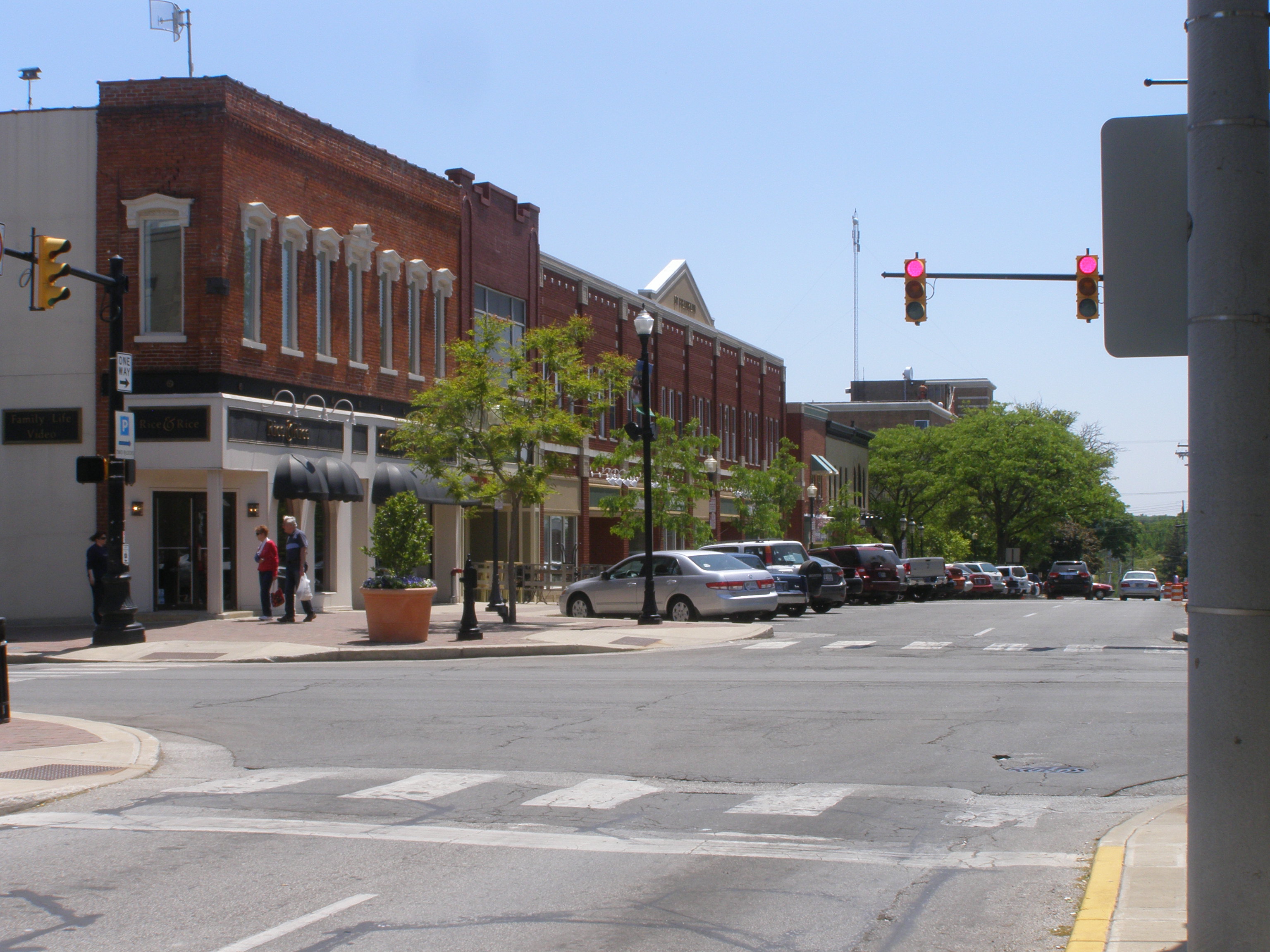

Franklin Street, east side of the Courthouse Square, Valparaiso
Towns
|
|
Townships
|
|
Railroads


Amtrak's Wolverine passing through Porter, Indiana
- Amtrak
- Chesapeake and Indiana Railroad
- Chicago Fort Wayne and Eastern Railroad
- Chicago, Southshore and South Bend Railroad
- CSX Transportation
- Norfolk Southern Railway
- Canadian National(Formerly Grand Trunk Western)
Adjacent counties
- LaPorte County (east)
- Starke County (southeast)
- Jasper County (south)
- Lake County (west)
- Cook County, Illinois (northwest, boundary in Lake Michigan)
- Berrien County, Michigan (northeast, boundary in Lake Michigan)
National protected area
- Indiana Dunes National Lakeshore (part)
Climate and weather
| Climate chart for Valparaiso, Indiana | |||||||||||
|---|---|---|---|---|---|---|---|---|---|---|---|
| J | F | M | A | M | J | J | A | S | O | N | D |
2.11
30
15
|
1.82
36
20
|
2.93
47
29
|
3.64
60
38
|
3.85
71
49
|
4.66
80
58
|
3.82
83
63
|
3.91
81
61
|
3.68
74
54
|
3.20
63
43
|
3.56
48
33
|
2.88
35
22
|
| temperatures in °C • precipitation totals in mm source: The Weather Channel[9] | |||||||||||
In recent years, average temperatures in Valparaiso have ranged from a low of 15 °F (−9 °C) in January to a high of 83 °F (28 °C) in July, although a record low of −25 °F (−31.7 °C) was recorded in January 1985 and a record high of 105 °F (41 °C) was recorded in July 1934. Average monthly precipitation ranged from 1.82 inches (46 mm) in February to 4.66 inches (118 mm) in June.[9]
Government
The county government is a constitutional body, and is granted specific powers by the Constitution of Indiana, and by the Indiana Code.
County Council: The county council is the legislative branch of the county government and controls all the spending and revenue collection in the county. Representatives are elected from county districts. The council members serve four year terms. They are responsible for setting salaries, the annual budget and special spending. The council also has limited authority to impose local taxes, in the form of an income and property tax that is subject to state level approval, excise taxes and service taxes.[10][11]
Board of Commissioners: The executive body of the county is made of a board of commissioners. The commissioners are elected county-wide, in staggered terms, and each serves a four-year term. One of the commissioners, typically the most senior, serves as president. The commissioners are charged with executing the acts legislated by the council, the collection of revenue and managing the day-to-day functions of the county government.[10][11]
Court: The county maintains a small claims court that can handle some civil cases. The judge on the court is elected to a term of four years and must be a member of the Indiana Bar Association. The judge is assisted by a constable who is also elected to a four-year term. In some cases, court decisions can be appealed to the state level circuit court.[11]
County Officials: The county has several other elected offices, including sheriff, coroner, auditor, treasurer, recorder, surveyor, and circuit court clerk Each of these elected officers serves a term of four years and oversees a different part of county government. Members elected to county government positions are required to declare party affiliations and to be residents of the county.[11]
Porter County is part of Indiana's 1st congressional district and in 2008 was represented by Pete Visclosky in the United States Congress.[12]
Demographics
| Porter County Population by year | |
|
2010 164,343 | |
As of the census[13] of 2000, there were 146,798 people, 54,649 households, and 39,729 families residing in the county. The population density was 351 people per square mile (136/km²). There were 57,616 housing units at an average density of 138 per square mile (53/km²). The racial makeup of the county was 95.33% White, 0.92% Black or African American, 0.22% Native American, 0.91% Asian, 0.03% Pacific Islander, 1.26% from other races, and 1.32% from two or more races. 4.82% of the population were Hispanic or Latino of any race. 23.7% were of German, 12.3% Irish, 8.3% Polish, 8.0% English and 7.9% American ancestry according to Census 2000.
There were 54,649 households out of which 35.00% had children under the age of 18 living with them, 59.80% were married couples living together, 9.20% had a female householder with no husband present, and 27.30% were non-families. 22.20% of all households were made up of individuals and 8.00% had someone living alone who was 65 years of age or older. The average household size was 2.62 and the average family size was 3.08.
In the county the population was spread out with 25.80% under the age of 18, 9.80% from 18 to 24, 28.90% from 25 to 44, 24.60% from 45 to 64, and 10.90% who were 65 years of age or older. The median age was 36 years. For every 100 females there were 96.40 males. For every 100 females age 18 and over, there were 93.90 males.
The median income for a household in the county was $53,100, and the median income for a family was $61,880. Males had a median income of $50,167 versus $26,347 for females. The per capita income for the county was $23,957. About 3.90% of families and 5.90% of the population were below the poverty line, including 6.80% of those under age 18 and 5.60% of those age 65 or over.
Education
Higher Education Campuses include:
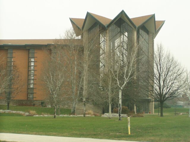

Valparaiso University Chapel
- Valparaiso University [1]
Valparaiso University is a Lutheran 4-year degree granting institution.
- Ivy Tech Community College [2]
Public schools in Porter County are administered by several districts, most of which cover areas that roughly follow the county's township boundaries.
- Duneland School Corporation [3] - Jackson, Liberty, & Westchester Townships
- East Porter County School Corporation [4] - Morgan, Pleasant, & Washington Townships
- Metropolitan School District of Boone Township [5] - Boone Township
- Portage Township Schools [6] - Portage Township
- Porter Township School Corporation [7] - Porter Township
- Union Township School Corporation [8] - Union Township
- Valparaiso Community Schools [9] - Center Township
High Schools and Middle Schools
Elementary Schools
|
|
Places of worship
Porter County has many options for people of faith. There are over 100 houses of worship. They include 35 denominations of the Christian faith, two synagogues.[14] and the Islamic Center of Michigan City[15]
| Jewish Houses of worship | Name | Location | Township | Picture |
|---|---|---|---|---|
| Temple of Israel of Porter County | Evans Ave, Valparaiso | Center | 
| |
| Messianic | Hope of Israel Congregation | Lincolnway, Valparaiso | Center |
| Muslim House of worship | Name | Location | Township | Picture |
|---|---|---|---|---|
| Islamic Center of Michigan City | County Road 500 East | Pines |
| Christian Denomination | Name | Location | Township | Picture |
|---|---|---|---|---|
| Assembly of God | Heartland Christian Center[16] | 170 South State Road 49, Valparaiso | Morgan | |
| Baptist | Old Pathway Baptist Church[16] | 219 Francis, Porter | Westchester | |
| Baptist | Kouts Family Baptist Church, Inc[16] | 403 E. Indiana St, Kouts | Pleasant | |
| Baptist | Emmanuel Baptist Church[16] | 769 West 800 South, Hebron | Boone | |
| Baptist | Calvary Church | Harrison Rd, Valparaiso | Center | |
| Christian | Central Christian Church[16] | Glendale and Campbell Aves, Valparaiso | Center | |
| Christian | First Christian Church (Disciples of Christ)[16] | 1507 Glendale Ave, Valparaiso | Center | 
|
| Christ Presbyterian | First Presbyterian Church of Valparaiso[16] | 3401 Valparaiso St, Valparaiso | Center | |
| Evangelical Free | Washington Evangelical Free Church | 3805 LaPorte Ave, Valparaiso | Washington | |
| Lutheran | St. Paul's Lutheran Church | Kouts | Pleasant | File:Lutheran Church Kouts Ind.jpg |
| Lutheran | St. Michael Lutheran Church[16] | 805 S. County Line Rd, Hebron | Boone | |
| Lutheran | Trinity Lutheran Church[16] | 201 Washington St. Valparaiso | Center | |
| Methodist | First United Methodist Church (Valpo Methodist)[16] | 103 N. Franklin St, Valparaiso | Center | |
| Methodist | First United Methodist Church (New Song Fellowship)[16] | 212 E. Lincolnway, Valparaiso | Center | |
| Mennonite | Valparaiso Mennonite, Valparaiso | Silhavy Road, Valparaiso | Center | 
|
| Nazarene | Nazarene Church of Valparaiso | Silhavy and Glendale Blvd, Valparaiso | Center | 
|
| Non-Denominational | New Hope Missionary Church[16] | 402 S. SR 49, Valparaiso | Morgan | |
| Non-Denominational | Faith Evangelical Bible Church[16] | 305 E. 400 N, Valparaiso | Washington | |
| Non-Denominational | Church of Christ[16] | 219 S 15th St, Chesterton | Westchester | |
| Non-Denominational | Vale Church of Christ | Silhavy Road, Valparaiso | Center | 
|
| Non-Denominational | New Hope Church of God[16] | 712 N. 450 W, South Haven | Portage | |
| Non-Denominational | Full Gospel, The Faith Mission Church[16] | CR 500 N, so of US 6 | Jackson | |
| Non-Denominational | Healing Place[16] | 2001 W Morgan Ave, Chesterton | Westchester | |
| Non-Denominational | House of Prayer Church[16] | 2738 Blake Rd, Portage | Portage | |
| Roman Catholic | St. Mary's Church | S.R. 8, Kouts | Pleasant | 
|
| Roman Catholic | Nativity of Our Savior | Willowcreek Road, Portage | Portage | |
| United Church of Christ | Union Community Church[16] | 602 Monroe St, Valparaiso | Center |
Porter County Cemeteries
The earliest Cemetery in Porter County is the Bailly Cemetery, 1827.[17] After the original burial in 1827, numerous other burials occurred. Additional cemeteries were created as the population grew. Early cemeteries were often family owned or church related. As communities grew, community cemeteries developed. The newest cemetery in the county is Angel Crest Cemetery, just off Indiana State Road 49, north of Valparaiso.
Porter County Parks
Porter County has grown from a single park, Sunset Hill Farm, to four, including: Calumet Trail, Dunn's Bridge, and the newest, Brinkca-Cross Gardens'[18]
- Sunset Hill Farm County Park. Located at 775 Meridian Rd, just south of U.S. 6 the Park consist of 238 acres (96.3 ha). There are several habitats accessible by trail, including; prairie lands, ponds and woods. Built around the Col. Murray farm, the open meadows are used for festivals and events. Colonel Robert Heffron Murray, a Chicago businessman. He and his first wife, Sue Horton Murray purchased 80 acres (320,000 m2) in 1934. With additional purchases, the farm grew to its present size. After the Colonel's death, his second wife Elizabeth Murray and ownership was placed in the county.[19]
- Calumet Trail. The trail is {{convert}9.1|mile|km}} long, parallel to U.S. 12, at the north end of the county. The trail is a mixed use trail, designed for walking, running, biking and cross-country skiing. Its eastern end is just north of where U.S. 12 crosses the tracks in The Town of the Pines. The trail follows the power line west, ending at Mineral Springs Road, where it crosses the railroad track. A restroom can be found at the western end. Water is not available.[20]
- Dunn's Bridge. Located on the southern boundary of the county on County Road 500 East, Dunn's Bridge spans the ]]Kankakee River]] to Jasper county. It is one of the oldest landmarks in the region. Built over a century ago across the Kankakee River by a resident farmer named Dunn, legend suggests that its origins may be traced to the famous George Ferris, creator of the first 'Ferris Wheel'. The park provides small boat access to the Kankakee River and a parking lot.[21]
- Brinkca-Cross Gardens Located at 27 E. Furness Rd. in Pine Township the garden offers 4 acres (1.6 ha) of trees and shrubs. Slopes and hills create vistas that of flower gardens and numerous hidden plantings, imported by the team of William Brincka and Basil Cross. The Hosta Garden contains many species propagated by Mr. Brincka.[22]
See also
- National Register of Historic Places listings in Porter County, Indiana
Notes
- ^ "Find a County". National Association of Counties. http://www.naco.org/Counties/Pages/FindACounty.aspx. Retrieved 2011-06-07.
- ^ a b Atlas of Great Lakes Indian History; Helen Hornbeck Tanner; University of Oklahoma Press, Norman, Oklahoma; 1987; Map 5
- ^ Geology of the Great Lakes; Jack L. Hough; University of Illinois Press, Urbana, 1958; p 276
- ^ One of the Earliest Authentic Histories of Porter County, Indiana; From 1832 to 1876; Deborah H. Shults-Gay; circa 1917
- ^ Calumet Beginnings: Schoon, Kenneth J.
- ^ Baker, Ronald L.; Marvin Carmony (1995). Indiana Place Names. Bloomington: Indiana University Press. p. 133. ISBN 0-253-28340-X.
- ^ De Witt Clinton Goodrich & Charles Richard Tuttle (1875). An Illustrated History of the State of Indiana. Indiana: R. S. Peale & co.. pp. 570. http://books.google.com/books?id=YDIUAAAAYAAJ.
- ^ "Census 2000 U.S. Gazetteer Files: Counties". United States Census. http://www.census.gov/tiger/tms/gazetteer/county2k.txt. Retrieved 2011-02-06.
- ^ a b "Monthly Averages for Valparaiso, Indiana". The Weather Channel. http://www.weather.com/weather/wxclimatology/monthly/graph/USIN0680. Retrieved 2011-01-27.
- ^ a b Indiana Code. "Title 36, Article 2, Section 3". IN.gov. http://www.in.gov/legislative/ic/code/title36/ar2/ch3.html. Retrieved 2008-09-16.
- ^ a b c d Indiana Code. "Title 2, Article 10, Section 2". IN.gov. http://www.in.gov/legislative/ic/code/title3/ar10/ch2.pdf. Retrieved 2008-09-16.
- ^ "US Congressman Pete Visclosky". US Congress. http://www.house.gov/visclosky/. Retrieved 2008-10-08.
- ^ "American FactFinder". United States Census Bureau. http://factfinder.census.gov. Retrieved 2008-01-31.
- ^ Yellowbook, Portage/Valparaiso; 2009–2010
- ^ Yellow Pages
- ^ a b c d e f g h i j k l m n o p q r s Family Flyer, August 2009
- ^ BAILLY CEMETERY, at Baileytown, near Porter, Westchester Township, Porter County Indiana; Cemetery of the Pioneer family of HONORE GRATIEN JOSEPH BAILLY de MESSEIN and Marie LeFevre, Burials 1827 to 1918; compiled by Olga Mae Schiemann; Chicago, Illinois; 1952
- ^ Porter County Parks and Recreation
- ^ Sunset Hill Farm Park
- ^ Calumet Trail
- ^ Dunn's Bridge
- ^ Binkca-Cross Gardens
External links
- Official Porter County website
- Porter County GenWeb - county history and genealogy website
- Porter County Municipal Airport (VPZ)
- Porter County Public Library System
- Center Township Trustee Website (Information about Township Assistance for those experiencing financial difficulties.)
- Center Township Trustee Facebook Page (Information about Center Township)
References
- Forstall, Richard L. (editor) (1996). Population of states and counties of the United States: 1790 to 1990: from the twenty-one decennial censuses. United States Department of Commerce, Bureau of the Census, Population Division. ISBN 0-934213-48-8.

|
Cook County, Illinois | Lake Michigan | Berrien County, Michigan |
|
| Lake County | LaPorte County | |||
 Porter County, Indiana | ||||
| Jasper County | Starke County |
| ||||||||||||||||||||
| ||||||||||||||||||||||||||
.jpg)
.jpg)
| This page uses content from the English language Wikipedia. The original content was at Porter County, Indiana. The list of authors can be seen in the page history. As with this Familypedia wiki, the content of Wikipedia is available under the Creative Commons License. |