| Main | Births etc |
|---|
| Püspökladány | |||
|---|---|---|---|
| — Town (város) — | |||
 |
|||
|
|||
 |
|||

Püspökladány |
|||

Püspökladány |
|||
| Coordinates: Coordinates: | |||
| Country | |||
| Region | Northern Great Plain Region | ||
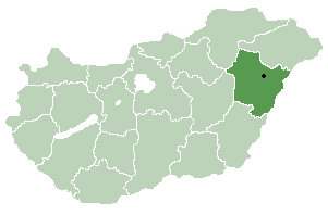
| County | Hajdú-Bihar County | ||
| Subregion | Püspökladány | ||
| Government | |||
| • Mayor | Imréné Dombi | ||
| Area | |||
| • Total | 186.95 km2 (72.18 sq mi) | ||
| Elevation | 85 m (279 ft) | ||
| Population (1 Jan 2015) | |||
| • Total | 14 605 | ||
| • Density | 79.78/km2 (206.6/sq mi) | ||
| Postal code | 4150 | ||
| Dialing code | 54 | ||
| Website | http://www.puspokladany.hu/ | ||

Püspökladány is a town in Hajdú-Bihar County, Northern Great Plain Region, Hungary with a population of approximately 16,000 people. It is located southwest of Debrecen at the juncture of three regions: Sárrét, Hortobágy and Nagykunság. It is an important transportation hub at the junction of national highway 4 from Budapest to Záhony, and national highway No. 42 from Romania to Biharkeresztes. The town is served by four different rail lines.
International relations[]
See also: List of twin towns and sister cities in Hungary
Twin towns — Sister cities[]
Püspökladány is twinned with:
 Hämeenlinna, Finland
- Fischamend, Austria
- Ghindari, Romania
- Hattem, Netherlands
- Krasnystaw, Poland
External links[]
Wikimedia Commons has media related to:
- Health Spa in Püspökladány
- Welcome to Püspökladány
- Accommodations in and around Püspökladány
- More info and accommodations
- Official site of Püspökladány
| |||||||||||||||||
