| Main | Births etc |
|---|
| Oxford, Pennsylvania | |
| Borough | |
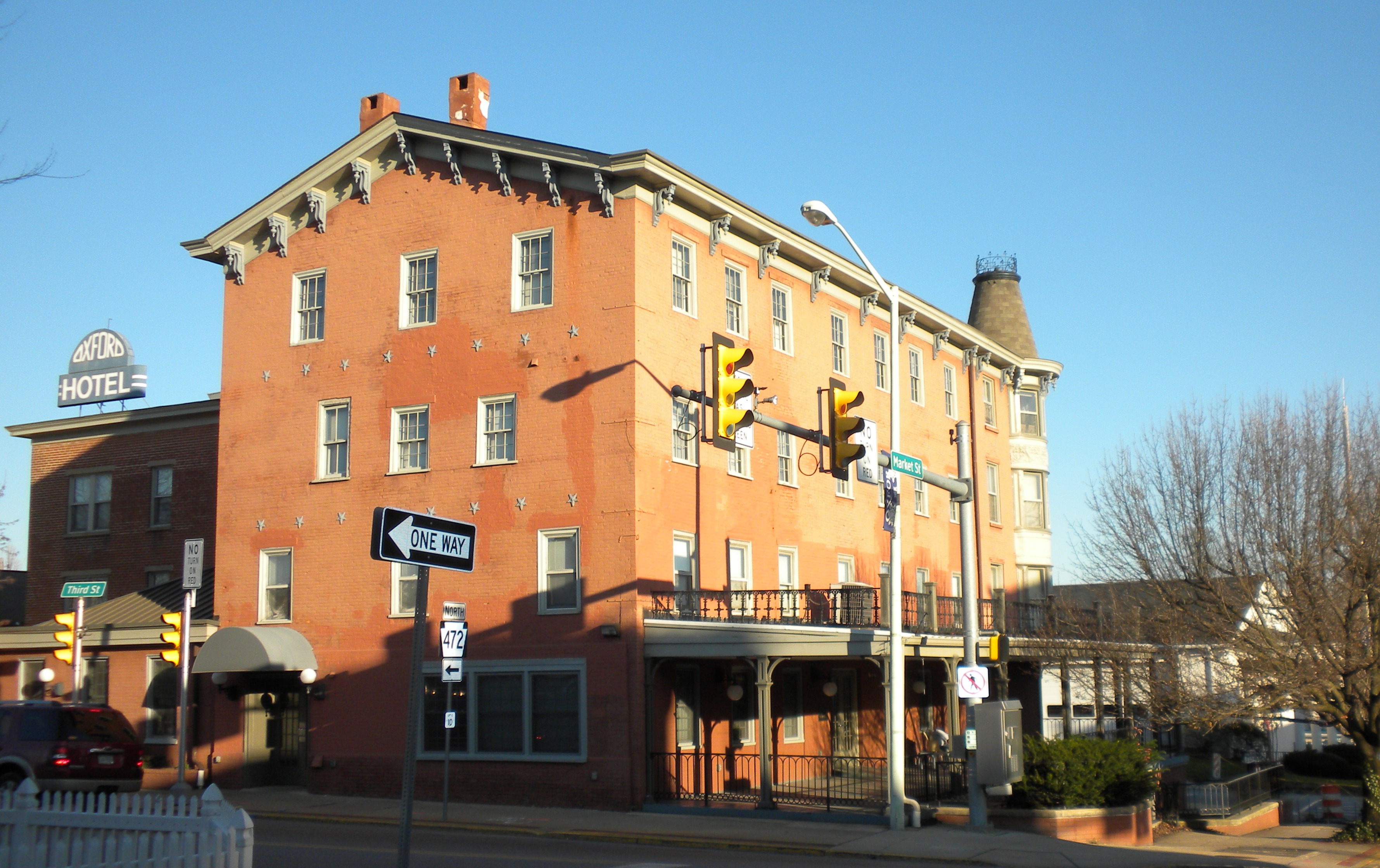 Oxford Hotel
| |
| Country | United States |
|---|---|
| State | Pennsylvania |
| County | Chester |
| Elevation | 535 ft (163.1 m) |
| Coordinates | |
| Area | 2.0 sq mi (5.2 km²) |
| - land | 2.0 sq mi (5 km²) |
| - water | 0.0 sq mi (0 km²), 0% |
| Population | 5,077 (2010) |
| Density | 2,590.3 / sq mi (1,000.1 / km²) |
| Incorporated | 1833 |
| Timezone | EST (UTC-5) |
| - summer (DST) | EDT (UTC-4) |
| ZIP Code | 19363 |
| Area code | 610 |
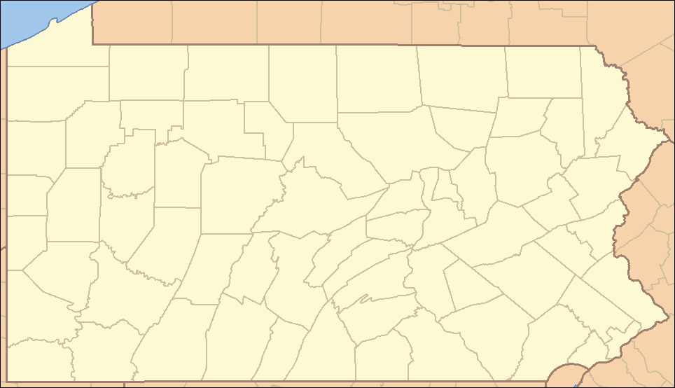 Location of Oxford in Pennsylvania
| |
 Location of Pennsylvania in the United States
| |
| Website: oxfordboro.org | |
Oxford is a borough in Chester County, Pennsylvania, United States. Oxford is the closest town to Lincoln University. The population was 5,077 at the 2010 census.[1]
History[]
The borough was once called Oxford Crossing and Oxford Village.
Oxford was located near the half-way point on the main road from Philadelphia to Baltimore. The owner of the stage between the two cities purchased Hood's Tavern and renamed it Oxford Hotel. It became the stopping point on the two-day trip between the two cities.
In 1833, Oxford was officially incorporated as a borough. Its first burgess (now called the mayor) was Thomas Alexander, who operated a general store in which the oldest public library in Pennsylvania was located. His store is thought to be the oldest building in Oxford.
The northern half of Oxford was owned by the Dickey family in the 19th century. The Dickeys included the local Presbyterian minister, the Mr O'Malley of the local bank, a state Representative, and local businessmen. Reverend John Miller Dickey and his wife Sarah Emlen Cresson founded Ashmun Institute in 1854, and which later became Lincoln University. The family played a major role in re-routing the new Philadelphia and Baltimore Central Railroad (P&BC) through Oxford. Track was laid in the 1850s. The railroad reached Oxford in 1860 and later connected to Philadelphia and Baltimore.[2] By the time of the Civil War, Oxford was a bustling community. The business district on Third Street was entirely re-built at this time, including the Oxford Hotel (1858) and Oxford Hall (1862). Oxford became known for its confectionery and candy businesses and was the location of many manufacturing facilities. A second railroad, the Peach Bottom Railway, was built in the 1870s from Oxford to Peach Bottom. It carried farm products and passengers but was not profitable. It struggled through three bankruptcies and reorganized as the Lancaster, Oxford and Southern Railway, finally closing permanently in 1918.[3]
The Pennsylvania Railroad took control of the P&BC on the eve of World War I. Passenger train service on the line ended in 1935.[4] In the late 20th century, transportation changes resulted in Oxford being located off the main roads. A bypass was constructed for U.S. Route 1 in the late 1960s,[5] but the major change was the 1963 opening of Interstate 95, which shifted the bulk of the Philadelphia-Baltimore traffic away from Oxford. The former Pennsylvania Railroad Station is now the local police station.[6]
The Oxford Historic District and Oxford Hotel are listed on the National Register of Historic Places.[7]
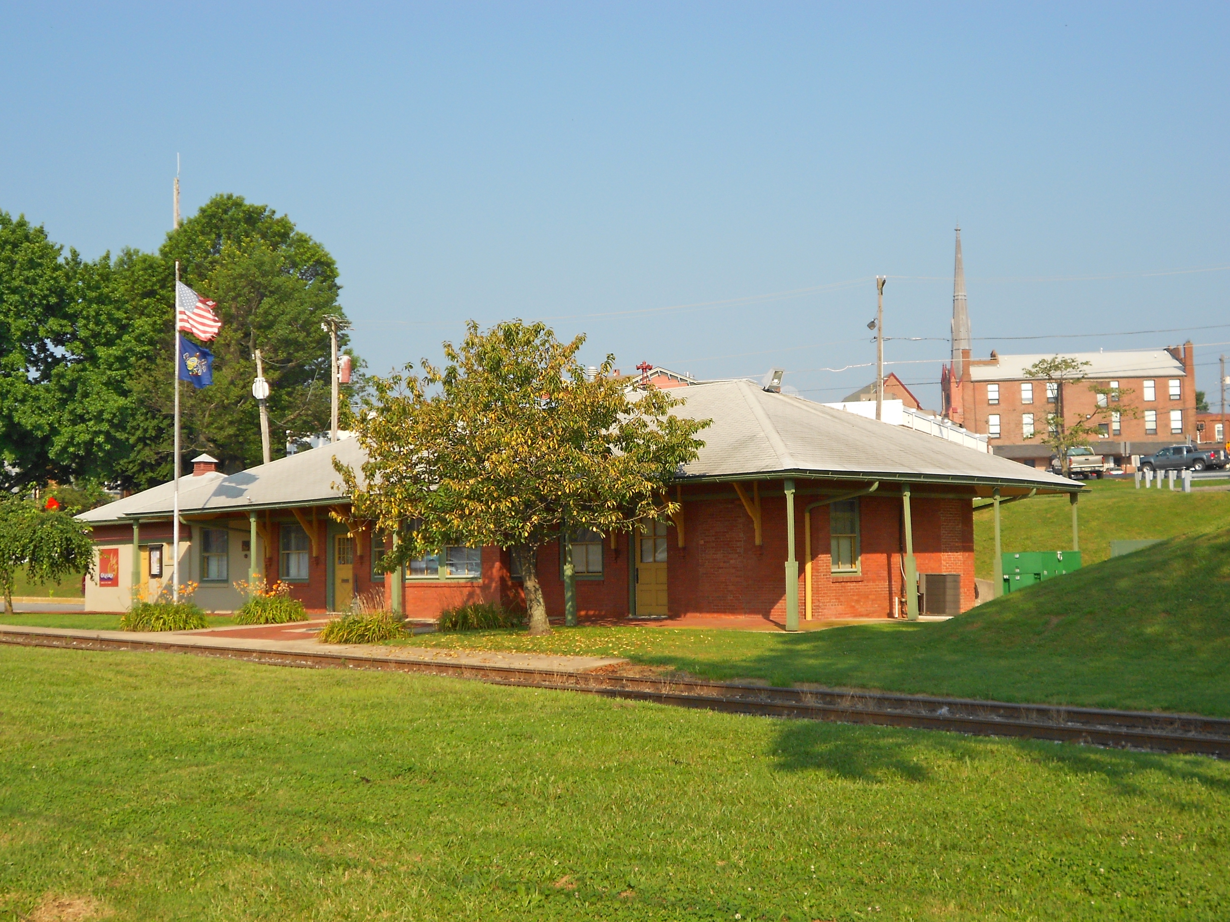

Borough Hall in the old train station
Geography[]
According to the United States Census Bureau, the borough has a total area of 1.9 square miles (4.9 km2), all of it land.
Demographics[]
| Historical populations | |||
|---|---|---|---|
| Census | Pop. | %± | |
| 1930 | 2,606 | ||
| 1940 | 2,723 | 4.5% | |
| 1950 | 3,091 | 13.5% | |
| 1960 | 3,376 | 9.2% | |
| 1970 | 3,658 | 8.4% | |
| 1980 | 3,633 | −0.7% | |
| 1990 | 3,769 | 3.7% | |
| 2000 | 4,315 | 14.5% | |
| 2010 | 5,077 | 17.7% | |
At the 2010 census, the borough was 59.9% non-Hispanic White, 9.0% Black or African American, 0.4% Native American, 0.8% Asian, 0.1% Native Hawaiian or Pacific Islander, and 4.0% were two or more races. 28.8% of the population were of Hispanic or Latino ancestry [1].
As of the census[8] of 2000, there were 4,315 people, 1,703 households, and 1,047 families residing in the borough. The population density was 2,254.6 people per square mile (872.3/km²). There were 1,825 housing units at an average density of 953.6/sq mi (368.9/km²). The racial makeup of the borough was 77.75% White, 11.87% African American, 0.09% Native American, 0.63% Asian, 0.23% Pacific Islander, 7.39% from other races, and 2.04% from two or more races. Hispanic or Latino of any race were 16.15% of the population.
There were 1,703 households out of which 30.5% had children under the age of 18 living with them, 42.8% were married couples living together, 14.0% had a female householder with no husband present, and 38.5% were non-families. 33.6% of all households were made up of individuals and 17.1% had someone living alone who was 65 years of age or older. The average household size was 2.45 and the average family size was 3.15.
In the borough the population was spread out with 25.6% under the age of 18, 9.1% from 18 to 24, 26.5% from 25 to 44, 19.0% from 45 to 64, and 19.8% who were 65 years of age or older. The median age was 37 years. For every 100 females there were 85.3 males. For every 100 females age 18 and over, there were 78.0 males.
The median income for a household in the borough was $34,966, and the median income for a family was $41,172. Males had a median income of $35,398 versus $23,015 for females. The per capita income for the borough was $16,579. About 10.0% of families and 11.8% of the population were below the poverty line, including 15.3% of those under age 18 and 12.9% of those age 65 or over.
Points of interest[]


Town clock on the National Penn Bank
The Oxford Town Clock, on the National Penn bank on South Third Street, was restored in May 2001.
Education[]


Oxford Grain and Hay
The local public school district is the Oxford Area School District. There are six schools associated with the district: Jordan Bank Elementary, Elk Ridge Elementary, Nottingham Elementary, Hopewell Elementary, Penn's Grove Middle, and Oxford Area High School. Sacred Heart School is also located in Oxford, but is considered part of the Archdiocese of Philadelphia.
Oxford is the closest town to Lincoln University, the first historically black college in the United States.
References[]
- ^ "Profile of General Population and Housing Characteristics: 2010 Demographic Profile Data (DP-1): Oxford borough, Pennsylvania". U.S. Census Bureau, American Factfinder. http://factfinder2.census.gov. Retrieved August 20, 2012.
- ^ Garrett, Jerre. "The Baltimore Central Railroad Reaches Rising Sun." Accessed 2011-09-14.
- ^ Hilton, George W. (1999). The Ma & Pa: A History of the Maryland & Pennsylvania Railroad (2nd ed.). Baltimore: Johns Hopkins University Press. pp. 29-36. ISBN 9780801862946.
- ^ Dixon, Mike. "All’s Quiet on the Octoraro Branch Line." Window on Cecil County's Past. 2008-10-20.
- ^ "US 1 Expressway-South of Philadelphia Section." The Roads of Metro Philadelphia. Accessed 2011-09-14.
- ^ Existing Railroad Stations in Chester County, Pennsylvania
- ^ "National Register Information System". National Register of Historic Places. National Park Service. 2010-07-09. http://nrhp.focus.nps.gov/natreg/docs/All_Data.html.
- ^ "American FactFinder". United States Census Bureau. http://factfinder.census.gov. Retrieved 2008-01-31.
External links[]
| |||||||||||||||||||||||

| This page uses content from the English language Wikipedia. The original content was at Oxford, Pennsylvania. The list of authors can be seen in the page history. As with this Familypedia wiki, the content of Wikipedia is available under the Creative Commons License. |