m (AWB cleanup- template:wp) |
m (Update from wikipedia) |
||
| Line 1: | Line 1: | ||
{{Navbox county-india}}<!--copy this line to other articles for this county! --> |
{{Navbox county-india}}<!--copy this line to other articles for this county! --> |
||
{{Perspective-Place article}} <!--delete this warning if the article has reached minimal family history standards --> |
{{Perspective-Place article}} <!--delete this warning if the article has reached minimal family history standards --> |
||
| + | {{About|the district|its eponymous headquarters|Nagpur}} |
||
| ⚫ | '''Nagpur district''' is a [[Districts of Maharashtra|district]] of [[ |
||
| + | {{India Districts |
||
| + | |Name = Nagpur |
||
| + | |Local = नागपूर जिल्हा |
||
| ⚫ | |||
| + | |Division = [[Nagpur Division]] |
||
| + | |HQ = Nagpur |
||
| + | |Map = MaharashtraNagpur.png |
||
| + | |Area = 9897 |
||
| + | |Rain = 1205 |
||
| + | |Population = 46,53,171 |
||
| + | |Urban = 64.26% |
||
| + | |Year = 2011 |
||
| + | |Density = 470 |
||
| + | |Literacy = 89.5% |
||
| + | |SexRatio = 948 |
||
| + | |Tehsils = 1. [[Ramtek]], 2. [[Umred]], 3. [[Kalameshwar]], 4. [[Katol]], 5. [[Kamthi]], 6. [[Kuhi]], 7. [[Narkhed]], 8. [[Nagpur]], 9. Nagpur (Rural), 10. [[Parseoni]], 11. [[Bhiwapur]], 12. [[Mouda]], 13. [[Savner]], 14. [[Hingna]] |
||
| + | |LokSabha = 1. [[Nagpur (Lok Sabha constituency)|Nagpur]], 2. [[Ramtek (Lok Sabha constituency)|Ramtek (SC)]] (Based on [http://164.100.9.199/ecimaps/ecipdf/state_pc_Map/Maharashtra.pdf Election Commission website]) |
||
| + | |Assembly = |
||
| + | |Highways = [[National Highway 6 (India)|NH-6]], [[National Highway 7 (India)|NH-7]] |
||
| + | |Website = http://nagpur.nic.in/ |
||
| + | }} |
||
| ⚫ | |||
| + | Nagpur district is bounded by [[Bhandara district]] on the east, [[Chandrapur district]] on the southeast, [[Wardha district]] on the southwest, [[Amravati district]] on the northwest and [[Chhindwara district]] of [[Madhya Pradesh]] state on the north. |
||
| ⚫ | |||
| ⚫ | |||
| + | ==History== |
||
| ⚫ | |||
| + | In 1853, after the death of [[Nagpur kingdom#Raghoji III (1818-1853) and British rule|Raghoji III]], the [[princely state]] of Nagpur was annexed by the British and the territory occupied by the present district became part of [[Nagpur Province]]. In 1861, it was merged with the [[Central Provinces]] and Nagpur district became a part of one of its divisions, [[Nagpur division]]. In 1903, it became part of the [[Central Provinces and Berar]]. In 1950, Nagpur district became part of the newly formed [[Madhya Pradesh]] state and Nagpur became its capital. In 1956, after the [[States Reorganisation Act|reorganization of states]], Nagpur district was incorporated in [[Bombay state]]. In 1 May 1960, it became a district of Maharashtra state. |
||
| + | ==Geography== |
||
| ⚫ | |||
| + | [[Image:Nagpur.png|none|thumb|300px|left|Map of Nagpur district with major towns and rivers.]] |
||
| ⚫ | |||
| + | ===Climate=== |
||
| + | {{climate chart |
||
| + | |Nagpur |
||
| + | |12.4|28.6|10 |
||
| + | |15.0|32.1|12 |
||
| + | |19.0|36.3|18 |
||
| + | |23.9|40.2|13 |
||
| + | |27.9|42.6|16 |
||
| + | |26.3|37.8|172 |
||
| + | |24.1|31.5|304 |
||
| + | |23.6|30.4|292 |
||
| + | |22.9|31.8|194 |
||
| + | |19.8|32.6|51 |
||
| + | |14.9|30.4|12 |
||
| + | |12.1|28.2|17 |
||
| + | |source=[http://www.worldweather.org/066/c00533.htm World Weather Information Service] |
||
| + | |float=right |
||
| + | |clear=left |
||
| + | }} |
||
| + | |||
| + | {{Weather box |
||
| + | |location = Nagpur |
||
| + | |metric first = Yes |
||
| + | |single line = Yes |
||
| + | |Jan record high C = 33 |
||
| + | |Feb record high C = 37 |
||
| + | |Mar record high C = 41 |
||
| + | |Apr record high C = 47 |
||
| + | |May record high C = 48 |
||
| + | |Jun record high C = 45 |
||
| + | |Jul record high C = 38 |
||
| + | |Aug record high C = 40 |
||
| + | |Sep record high C = 39 |
||
| + | |Oct record high C = 37 |
||
| + | |Nov record high C = 35 |
||
| + | |Dec record high C = 32 |
||
| + | |year record high C = 48 |
||
| + | |Jan high C = 28.6 |
||
| + | |Feb high C = 32.1 |
||
| + | |Mar high C = 36.3 |
||
| + | |Apr high C = 40.2 |
||
| + | |May high C = 42.6 |
||
| + | |Jun high C = 37.8 |
||
| + | |Jul high C = 31.5 |
||
| + | |Aug high C = 30.4 |
||
| + | |Sep high C = 31.8 |
||
| + | |Oct high C = 32.6 |
||
| + | |Nov high C = 30.4 |
||
| + | |Dec high C = 28.2 |
||
| + | |year high C = 33.5 |
||
| + | |Jan low C = 12.4 |
||
| + | |Feb low C = 15.0 |
||
| + | |Mar low C = 19.0 |
||
| + | |Apr low C = 23.9 |
||
| + | |May low C = 27.9 |
||
| + | |Jun low C = 26.3 |
||
| + | |Jul low C = 24.1 |
||
| + | |Aug low C = 23.6 |
||
| + | |Sep low C = 22.9 |
||
| + | |Oct low C = 19.8 |
||
| + | |Nov low C = 14.9 |
||
| + | |Dec low C = 12.1 |
||
| + | |year low C = 20.2 |
||
| + | |Jan record low C = 7 |
||
| + | |Feb record low C = 8 |
||
| + | |Mar record low C = 12 |
||
| + | |Apr record low C = 17 |
||
| + | |May record low C = 18 |
||
| + | |Jun record low C = 20 |
||
| + | |Jul record low C = 20 |
||
| + | |Aug record low C = 20 |
||
| + | |Sep record low C = 19 |
||
| + | |Oct record low C = 11 |
||
| + | |Nov record low C = 5 |
||
| + | |Dec record low C = 5.5 |
||
| + | |year record low C = 5.9 |
||
| + | |Jan precipitation mm = 10.2 |
||
| + | |Feb precipitation mm = 12.3 |
||
| + | |Mar precipitation mm = 17.8 |
||
| + | |Apr precipitation mm = 13.2 |
||
| + | |May precipitation mm = 16.3 |
||
| + | |Jun precipitation mm = 172.2 |
||
| + | |Jul precipitation mm = 304.3 |
||
| + | |Aug precipitation mm = 291.6 |
||
| + | |Sep precipitation mm = 194.4 |
||
| + | |Oct precipitation mm = 51.4 |
||
| + | |Nov precipitation mm = 11.8 |
||
| + | |Dec precipitation mm = 17.2 |
||
| + | |year precipitation mm = 1112.7 |
||
| + | |source 1 =<ref name=Wht>{{Cite web|url=http://www.weatherbase.com/weather/weather.php3?s=35334&refer=&units=metric|title=Nagpur, India |publisher=Whetherbase |accessdate=2010-07-01 }}</ref> |
||
| + | |date=December 2010}} |
||
| + | |||
| + | ==Divisions== |
||
| + | Nagpur district is divided into 14 [[taluka]]s: [[Ramtek]], [[Umred]], [[Kalameshwar]], [[Katol]], [[Kamthi]], [[Kuhi]], [[Narkhed]], [[Nagpur]], Nagpur (Rural), [[Parseoni]], [[Bhiwapur]], [[Mouda]], [[Savner]] and [[Hingna]]. |
||
| + | |||
| + | Nagpur district has 12 [[Maharashtra Vidhan Sabha|Vidhan Sabha]] constituencies: [[Nagpur South West (Vidhan Sabha constituency)|Nagpur South West]], [[Nagpur South (Vidhan Sabha constituency)|Nagpur South]], [[Nagpur East (Vidhan Sabha constituency)|Nagpur East]], [[Nagpur Central (Vidhan Sabha constituency)|Nagpur Central]], [[Nagpur West (Vidhan Sabha constituency)|Nagpur West]], [[Nagpur North (Vidhan Sabha constituency)|Nagpur North]], [[Katol (Vidhan Sabha constituency)|Katol]], [[Savner (Vidhan Sabha constituency)|Savner]], [[Hingna (Vidhan Sabha constituency)|Hingna]], [[Umred (Vidhan Sabha constituency)|Umred]], [[Kamthi (Vidhan Sabha constituency)|Kamthi]] and [[Ramtek (Vidhan Sabha constituency)|Ramtek]]. The first six constituencies are part of [[Nagpur (Lok Sabha constituency)|Nagpur Lok Sabha constituency]] and rest are part of [[Ramtek (Lok Sabha constituency)|Ramtek Lok Sabha constituency]].<ref name=ceo>{{cite web|url=http://ceo.maharashtra.gov.in/acs.php|title=District wise List of Assembly and Parliamentary Constituencies|publisher=Chief Electoral Officer, Maharashtra website|accessdate=1 November 2010}}</ref> |
||
| + | |||
| + | ==Demographics== |
||
| + | According to the [[2011 census of India|2011 census]] Nagpur district has a [[Demographics of India|population]] of 4,653,171,<ref name=districtcensus>{{cite web | url = http://www.census2011.co.in/district.php | title = District Census 2011 | accessdate = 2011-09-30 | year = 2011 | publisher = Census2011.co.in}}</ref> roughly equal to the nation of [[Ireland]]<ref name="cia">{{cite web | author = US Directorate of Intelligence | title = Country Comparison:Population | url = https://www.cia.gov/library/publications/the-world-factbook/rankorder/2119rank.html | accessdate = 2011-10-01 | quote = |
||
| + | Ireland |
||
| + | 4,670,976 |
||
| + | July 2011 est. |
||
| + | }}</ref> or the US state of [[South Carolina]].<ref>{{cite web|url=http://2010.census.gov/2010census/data/apportionment-pop-text.php|title=2010 Resident Population Data|publisher=U. S. Census Bureau|accessdate=2011-09-30| quote = |
||
| + | South Carolina |
||
| + | 4,625,364 |
||
| + | }}</ref> This gives it a ranking of 29th in India (out of a total of [[Districts of India|640]]).<ref name=districtcensus/> The district has a population density of {{convert| 470 |PD/sqkm|PD/sqmi}} .<ref name=districtcensus/> Its [[Family planning in India|population growth rate]] over the decade 2001-2011 was 14.39 %.<ref name=districtcensus/> Nagpur has a [[sex ratio]] of 948 [[Women in India|females]] for every 1000 males,<ref name=districtcensus/> and a [[Literacy in India|literacy rate]] of 89.52 %.<ref name=districtcensus/> |
||
| + | |||
| + | The district had a population of 4,653,171 of which 64.26% were urban as of 2011.<ref>[http://www.censusindiamaps.net/page/India_WhizMap/IndiaMap.htm Census of India]</ref> The current [[District Collector]] is [[Sanjay Mukherjee]]. Nagpur district has following administrative bodies which have jurisdiction over different areas<ref name="Planning Authority">{{cite web|url=http://www.nagpur.nic.in/tp/planningauthorities.htm|title=Planning Authority of Nagpur district|publisher=Government of Maharashtra|accessdate=2009-01-08}}</ref> - |
||
| + | |||
| + | *[[Nagpur Municipal Corporation]] |
||
| + | *[[Nagpur Improvement Trust]] |
||
| + | *[[Narkhed Municipal Council]] |
||
| + | *[[Katol Municipal Council]] |
||
| + | *[[Saoner Municipal Council]] |
||
| + | *[[Ramtek Municipal Council]] |
||
| + | *[[Mowad Municipal Council]] |
||
| + | *[[Khapa Municipal Council]] |
||
| + | *[[Umred Municipal Council]] |
||
| + | *[[Narkhed Municipal Council]] |
||
| + | *[[Kamptee Municipal Council]] |
||
| + | *[[Kalmeshwar Municipal Council]] |
||
| + | |||
| + | ==Transport== |
||
| + | [[Dr. Babasaheb Ambedkar International Airport]] in Sonegaon, Nagpur is a domestic and international airport in this district, which connects Nagpur to Mumbai, Delhi, Sharjah, Dubai and Doha. |
||
| + | |||
| + | ==References== |
||
| + | {{reflist}} |
||
| + | |||
| + | ==External links== |
||
| + | |||
| + | {{Geographic location |
||
| + | |Centre = Nagpur district |
||
| + | |North = [[Seoni district]], [[Madhya Pradesh]] |
||
| + | |Northeast = [[Balaghat district]], [[Madhya Pradesh]] |
||
| + | |East = [[Bhandara district]] |
||
| + | |Southeast = |
||
| + | |South = [[Chandrapur district]] |
||
| + | |Southwest = [[Wardha district]] |
||
| + | |West = [[Amravati district]] |
||
| + | |Northwest = [[Chhindwara district]], [[Madhya Pradesh]] |
||
| + | }} |
||
| + | |||
| + | {{Nagpur district topics}} |
||
| + | {{Districts of Maharashtra}} |
||
| ⚫ | |||
| ⚫ | |||
| + | |||
| ⚫ | |||
| ⚫ | |||
| + | [[Category:Nagpur district| ]] |
||
| + | [[Category:Nagpur division]] |
||
| + | {{usedwp}} |
||
| − | <noinclude><small>{{usedwp|Nagpur district}}</small></noinclude> |
||
Latest revision as of 07:08, 24 November 2011
| ||||||||||||||
| Nagpur district नागपूर जिल्हा |
|
|---|---|
| — District of Maharashtra — | |
 |
|
| Country | India |
| State | Maharashtra |
| Administrative division | Nagpur Division |
| Established | |
| Headquarters | Nagpur |
| Tehsils | 1. Ramtek, 2. Umred, 3. Kalameshwar, 4. Katol, 5. Kamthi, 6. Kuhi, 7. Narkhed, 8. Nagpur, 9. Nagpur (Rural), 10. Parseoni, 11. Bhiwapur, 12. Mouda, 13. Savner, 14. Hingna |
| Government | |
| • Lok Sabha constituencies | 1. Nagpur, 2. Ramtek (SC) (Based on Election Commission website) |
| Area | |
| • Total | 9,897 km2 (3,821 sq mi) |
| Population (2011) | |
| • Total | 46,53,171 |
| • Density | 470/km2 (1,200/sq mi) |
| • Urban | 64.26% |
| Demographics | |
| • Literacy | 89.5% |
| • Sex ratio | 948 |
| Major highways | NH-6, NH-7 |
| Average annual precipitation | 1205 mm |
| Website | Official website |
Nagpur district (Marathi: नागपूर जिल्हा) is a district in the Vidarbha region of Maharashtra state in central India. The city of Nagpur is the district headquarters. The district is part of Nagpur Division.
Nagpur district is bounded by Bhandara district on the east, Chandrapur district on the southeast, Wardha district on the southwest, Amravati district on the northwest and Chhindwara district of Madhya Pradesh state on the north.
History[]
In 1853, after the death of Raghoji III, the princely state of Nagpur was annexed by the British and the territory occupied by the present district became part of Nagpur Province. In 1861, it was merged with the Central Provinces and Nagpur district became a part of one of its divisions, Nagpur division. In 1903, it became part of the Central Provinces and Berar. In 1950, Nagpur district became part of the newly formed Madhya Pradesh state and Nagpur became its capital. In 1956, after the reorganization of states, Nagpur district was incorporated in Bombay state. In 1 May 1960, it became a district of Maharashtra state.
Geography[]
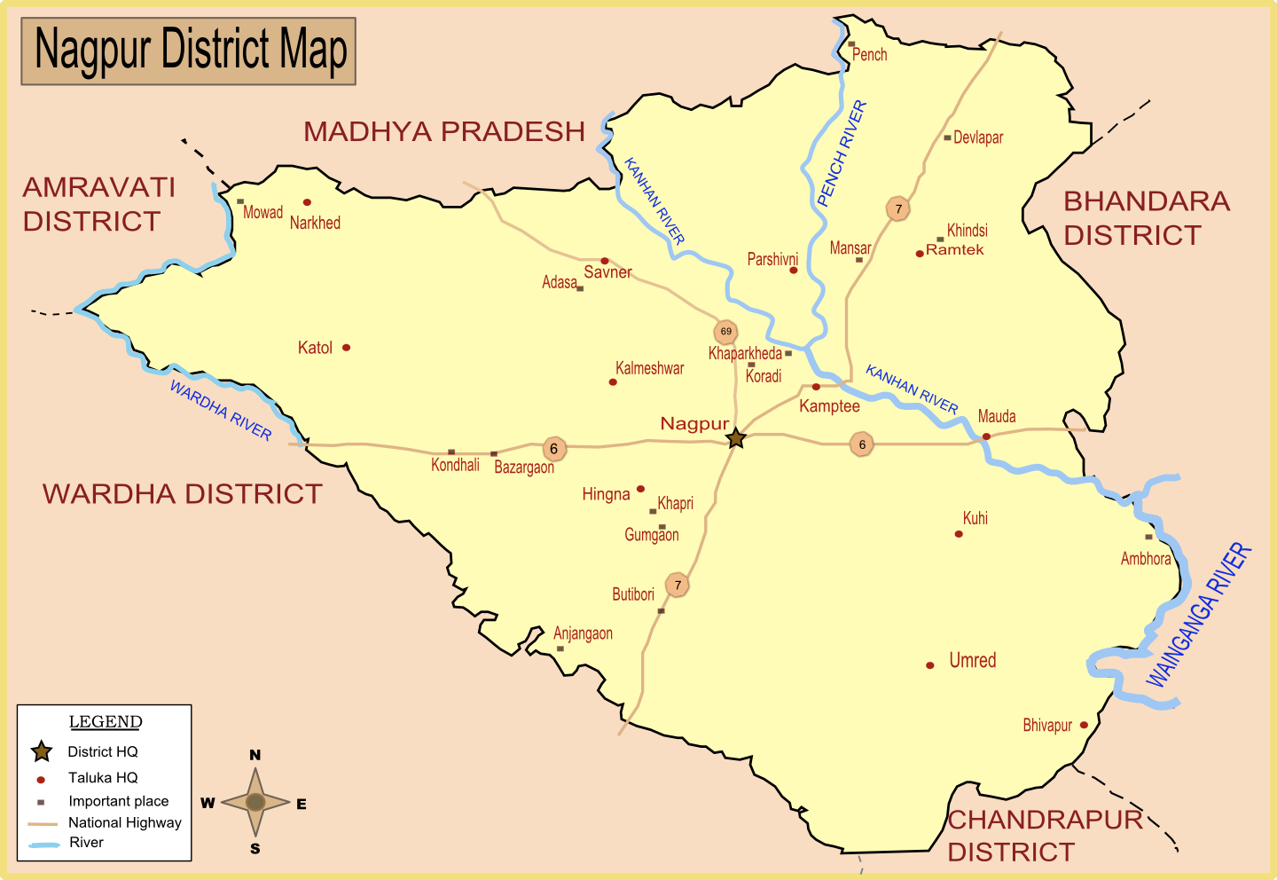
Map of Nagpur district with major towns and rivers.
Climate[]
| Climate chart for Nagpur | |||||||||||
|---|---|---|---|---|---|---|---|---|---|---|---|
| J | F | M | A | M | J | J | A | S | O | N | D |
10
28.6
12.4
|
12
32.1
15.0
|
18
36.3
19.0
|
13
40.2
23.9
|
16
42.6
27.9
|
172
37.8
26.3
|
304
31.5
24.1
|
292
30.4
23.6
|
194
31.8
22.9
|
51
32.6
19.8
|
12
30.4
14.9
|
17
28.2
12.1
|
| temperatures in °C • precipitation totals in mm source: World Weather Information Service | |||||||||||
| Climate data for Nagpur | |||||||||||||
|---|---|---|---|---|---|---|---|---|---|---|---|---|---|
| Month | Jan | Feb | Mar | Apr | May | Jun | Jul | Aug | Sep | Oct | Nov | Dec | Year |
| Record high °C (°F) | 33 (91) |
37 (99) |
41 (106) |
47 (117) |
48 (118) |
45 (113) |
38 (100) |
40 (104) |
39 (102) |
37 (99) |
35 (95) |
32 (90) |
48 (118) |
| Average high °C (°F) | 28.6 (83.5) |
32.1 (89.8) |
36.3 (97.3) |
40.2 (104.4) |
42.6 (108.7) |
37.8 (100.0) |
31.5 (88.7) |
30.4 (86.7) |
31.8 (89.2) |
32.6 (90.7) |
30.4 (86.7) |
28.2 (82.8) |
33.5 (92.3) |
| Average low °C (°F) | 12.4 (54.3) |
15.0 (59.0) |
19.0 (66.2) |
23.9 (75.0) |
27.9 (82.2) |
26.3 (79.3) |
24.1 (75.4) |
23.6 (74.5) |
22.9 (73.2) |
19.8 (67.6) |
14.9 (58.8) |
12.1 (53.8) |
20.2 (68.4) |
| Record low °C (°F) | 7 (45) |
8 (46) |
12 (54) |
17 (63) |
18 (64) |
20 (68) |
20 (68) |
20 (68) |
19 (66) |
11 (52) |
5 (41) |
5.5 (41.9) |
5.9 (42.6) |
| Precipitation mm (inches) | 10.2 (0.402) |
12.3 (0.484) |
17.8 (0.701) |
13.2 (0.52) |
16.3 (0.642) |
172.2 (6.78) |
304.3 (11.98) |
291.6 (11.48) |
194.4 (7.654) |
51.4 (2.024) |
11.8 (0.465) |
17.2 (0.677) |
1,112.7 (43.807) |
| Source: [1] | |||||||||||||
Divisions[]
Nagpur district is divided into 14 talukas: Ramtek, Umred, Kalameshwar, Katol, Kamthi, Kuhi, Narkhed, Nagpur, Nagpur (Rural), Parseoni, Bhiwapur, Mouda, Savner and Hingna.
Nagpur district has 12 Vidhan Sabha constituencies: Nagpur South West, Nagpur South, Nagpur East, Nagpur Central, Nagpur West, Nagpur North, Katol, Savner, Hingna, Umred, Kamthi and Ramtek. The first six constituencies are part of Nagpur Lok Sabha constituency and rest are part of Ramtek Lok Sabha constituency.[2]
Demographics[]
According to the 2011 census Nagpur district has a population of 4,653,171,[3] roughly equal to the nation of Ireland[4] or the US state of South Carolina.[5] This gives it a ranking of 29th in India (out of a total of 640).[3] The district has a population density of 470 inhabitants per square kilometre (1,200 /sq mi) .[3] Its population growth rate over the decade 2001-2011 was 14.39 %.[3] Nagpur has a sex ratio of 948 females for every 1000 males,[3] and a literacy rate of 89.52 %.[3]
The district had a population of 4,653,171 of which 64.26% were urban as of 2011.[6] The current District Collector is Sanjay Mukherjee. Nagpur district has following administrative bodies which have jurisdiction over different areas[7] -
- Nagpur Municipal Corporation
- Nagpur Improvement Trust
- Narkhed Municipal Council
- Katol Municipal Council
- Saoner Municipal Council
- Ramtek Municipal Council
- Mowad Municipal Council
- Khapa Municipal Council
- Umred Municipal Council
- Narkhed Municipal Council
- Kamptee Municipal Council
- Kalmeshwar Municipal Council
Transport[]
Dr. Babasaheb Ambedkar International Airport in Sonegaon, Nagpur is a domestic and international airport in this district, which connects Nagpur to Mumbai, Delhi, Sharjah, Dubai and Doha.
References[]
- ^ "Nagpur, India". Whetherbase. http://www.weatherbase.com/weather/weather.php3?s=35334&refer=&units=metric. Retrieved 2010-07-01.
- ^ "District wise List of Assembly and Parliamentary Constituencies". Chief Electoral Officer, Maharashtra website. http://ceo.maharashtra.gov.in/acs.php. Retrieved 1 November 2010.
- ^ a b c d e f "District Census 2011". Census2011.co.in. 2011. http://www.census2011.co.in/district.php. Retrieved 2011-09-30.
- ^ US Directorate of Intelligence. "Country Comparison:Population". https://www.cia.gov/library/publications/the-world-factbook/rankorder/2119rank.html. Retrieved 2011-10-01. "Ireland 4,670,976 July 2011 est."
- ^ "2010 Resident Population Data". U. S. Census Bureau. http://2010.census.gov/2010census/data/apportionment-pop-text.php. Retrieved 2011-09-30. "South Carolina 4,625,364"
- ^ Census of India
- ^ "Planning Authority of Nagpur district". Government of Maharashtra. http://www.nagpur.nic.in/tp/planningauthorities.htm. Retrieved 2009-01-08.
External links[]

|
Chhindwara district, Madhya Pradesh | Seoni district, Madhya Pradesh | Balaghat district, Madhya Pradesh |
|
| Amravati district | Bhandara district | |||
 Nagpur district | ||||
| Wardha district | Chandrapur district |
Template:Nagpur district topics
| ||||||||||||||||||||||||||||||||||||||||
| ||||||||||||||||||||||||||||||||||||||||
| This page uses content from the English language Wikipedia. The original content was at Nagpur district. The list of authors can be seen in the page history. As with this Familypedia wiki, the content of Wikipedia is available under the Creative Commons License. |