| Main | Births etc |
|---|
| Muchelney | |
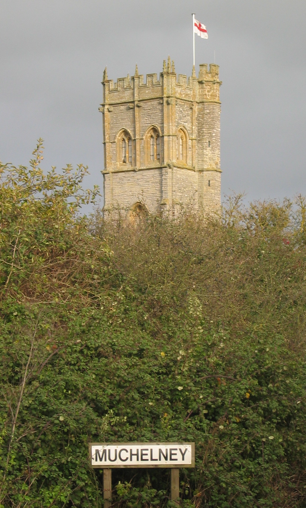 The tower of St Peter and St Paul church rises above Muchelney |
|
| |
| Population | 210 [1] |
|---|---|
| OS grid reference | |
| District | South Somerset |
| Shire county | Somerset |
| Region | South West |
| Country | England |
| Sovereign state | United Kingdom |
| Dialling code | 01458 |
| Police | Avon and Somerset |
| Fire | Devon and Somerset |
| Ambulance | South Western |
| EU Parliament | South West England |
| UK Parliament | Somerton and Frome |
| List of places: UK • England • Somerset | |
Muchelney is a village and civil parish in Somerset, England, on the River Parrett, 1.5 miles (2.4 km) south of Huish Episcopi and 5.5 miles (8.9 km) miles south west of Somerton in the South Somerset district. The village has a population of about 210.[1]
Adjacent to Muchelney are the hamlets of Thorney and Muchelney Ham.
History[]
The village was recorded as Micelenie in the Domesday book meaning 'the increasingly great island' from the Old English miclian and from the Norsk Øe.[2] The -ey or -y suffix served as the old English designation for "island", and thus is common to many of the villages in this area of the Somerset Levels, which stood as islands just above the marshes, which have since been drained.
The parish of Muchelney was part of the Pitney Hundred.[3]
The village is best known as the site of Muchelney Abbey, a Benedictine abbey founded by King Athelstan in 939, and largely demolished in the Dissolution of the Monasteries. Architectural details of houses in the surrounding area are thought to incorporate fragments scavenged when the Abbey was destroyed.[4]
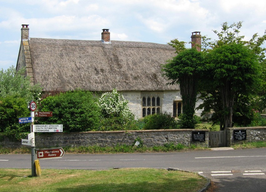

The thatched Priest's House
The remains of Muchelney Abbey, including Tudor monks' quarters, and exhibits, are managed by English Heritage. Other tourist attractions in Muchelney include the parish church of St Peter and St Paul; the Priest's House (built in 1308 and now managed by the National Trust), and the pottery of artist John Leach.
Governance[]
The parish council has responsibility for local issues, including setting an annual precept (local rate) to cover the council’s operating costs and producing annual accounts for public scrutiny. The parish council evaluates local planning applications and works with the local police, district council officers, and neighbourhood watch groups on matters of crime, security, and traffic. The parish council's role also includes initiating projects for the maintenance and repair of parish facilities, as well as consulting with the district council on the maintenance, repair, and improvement of highways, drainage, footpaths, public transport, and street cleaning. Conservation matters (including trees and listed buildings) and environmental issues are also the responsibility of the council.
The village falls within the non-metropolitan district of South Somerset, which was formed on 1 April 1974 under the Local Government Act 1972, having previously been part of Langport Rural District.[5] The district council is responsible for local planning and building control, local roads, council housing, environmental health, markets and fairs, refuse collection and recycling, cemeteries and crematoria, leisure services, parks, and tourism.
Somerset County Council is responsible for running the largest and most expensive local services such as education, social services, libraries, main roads, public transport, policing and fire services, trading standards, waste disposal and strategic planning.
It is also part of the Somerton and Frome county constituency represented in the House of Commons of the Parliament of the United Kingdom. It elects one Member of Parliament (MP) by the first past the post system of election, and part of the South West England constituency of the European Parliament which elects seven MEPs using the d'Hondt method of party-list proportional representation.
Geography[]
To the east is Wet Moor, a biological Site of Special Scientific Interest, which forms part of the extensive grazing marsh grasslands and ditch systems of the Somerset Levels and Moors.[6]
Muchelney regularly floods every winter, cutting its inhabitants off from vehicle access. To counter this they have taken to parking their cars away from the village in anticipation of flooding. When the floods have come they then share rides on a local tractor to get to their cars. In this way they can get food, supplies and get to work. However they are not always prepared for early flooding. In November 2012, during the 2012 Great Britain and Ireland floods, access to the village was cut-off for six days as no one had moved their cars and floods were too deep even for tractors. Rescue boats reached the village on 29 November, rescuing nearly 100 people.[7]
Religious sites[]
St Peter and St Paul Parish Church, adjacent to Muchelney Abbey, has a ceiling enlivened with Jacobean paintings of bare-breasted angels, their nudity thought to symbolize innocent purity. It has a three-stage Somerset tower supported by pairs of full-height corner buttresses. The south-east octagonal stair turret leads to an outer door.[8]
Culture[]
A highlight of the summer in Muchelney and adjacent Thorney is the Lowland Games, a light-hearted adaptation of the Highland games. Events over the years have included (hay) bale racing, raft racing, ferret racing, wellie tossing, a dog show, equestrian exhibitions, mud wrestling, and a battle of the bands (with the winning act getting a gig at the Glastonbury Festival).
")
")
")
References[]
- ^ a b "South Somerset population estimates for 2002". Somerset County Council. http://www.webcitation.org/5lRyCVNCk. Retrieved 27 December 2009.
- ^ Robinson, Stephen (1992). Somerset Place Names. Wimborne, Dorset: Dovecote Press. ISBN 1-874336-03-2.
- ^ "Somerset Hundreds". GENUKI. http://www.genuki.org.uk/big/eng/SOM/Miscellaneous/. Retrieved 18 October 2011.
- ^ The Buildings of England, South and West Somerset, by Nikolaus Pevsner. Penguin Books 1958; Reprinted by Yale Univ Press, 2003, page 251.
- ^ A Vision of Britain Through Time : Langport Rural District
- ^ "Wet Moor" (PDF). English Nature. http://www.english-nature.org.uk/citation/citation_photo/1004500.pdf. Retrieved 2006-09-09.
- ^ http://www.bbc.co.uk/news/uk-england-somerset-20524682
- ^ "Church of SS Peter and Paul, Muchelney". Images of England. http://www.imagesofengland.org.uk/Details/Default.aspx?id=263267. Retrieved 2007-09-25.
External links[]
| |||||||
| This page uses content from the English language Wikipedia. The original content was at Muchelney. The list of authors can be seen in the page history. As with this Familypedia wiki, the content of Wikipedia is available under the Creative Commons License. |