| Main | Births etc |
|---|
| Molnári | |||
|---|---|---|---|
| — Village — | |||
 |
|||
|
|||
 |
|||

Molnári |
|||
Molnári |
|||
| Coordinates: | |||
| Country | |||
| Region | Western Transdanubia | ||
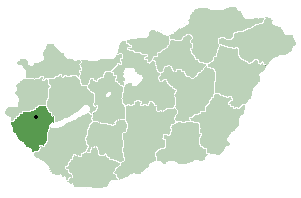
| County | Zala | ||
| Subregion | Letenye | ||
| First mentioned | 1321 | ||
| Government | |||
| • Mayor | István Vuk | ||
| Area | |||
| • Total | 12.86 km2 (4.97 sq mi) | ||
| Elevation | 140 m (460 ft) | ||
| Population (1 Jan 2015) | |||
| • Total | 713 | ||
| • Density | 54.90/km2 (142.2/sq mi) | ||
| Time zone | CET (UTC+1) | ||
| • Summer (DST) | CEST (UTC+2) | ||
| Postal code | 8863 | ||
| Area code(s) | 93 | ||
| Website | http://www.molnari.hu/ | ||

Molnári is a village in Zala County, Western Transdanubia Region, Hungary.
| |||||||||||||||||
