m (Established in 1284) |
No edit summary |
||
| (2 intermediate revisions by 2 users not shown) | |||
| Line 1: | Line 1: | ||
| − | |||
{{Navbox county-uk}}<!--copy this line to other articles for this county! --> |
{{Navbox county-uk}}<!--copy this line to other articles for this county! --> |
||
{{Perspective-Place article}} <!--delete this warning if the article has reached minimal family history standards --> |
{{Perspective-Place article}} <!--delete this warning if the article has reached minimal family history standards --> |
||
| − | {{ |
+ | {{Infobox historic subdivision| |
| − | | |
+ | |Name= Merionethshire |
| − | | |
+ | |HQ= [[Dolgellau]] |
| + | |Government= Merionethshire County Council (1889-1974) |
||
| ⚫ | |||
| − | | |
+ | |Origin= |
| + | |Status= |
||
| − | |CountyTown= {{wp|Dolgellau}} |
||
| + | |Start= 1284 |
||
| − | |ChapmanCode=MER |
||
| + | |End= |
||
| − | }} |
||
| + | |Code= MER |
||
| ⚫ | |||
| + | |CodeName= [[Chapman code]] |
||
| + | |Replace= [[Meirionnydd]] |
||
| + | |Motto= Tra môr, tra Meirion <br />(While the sea lasts, so shall Meirionnydd) |
||
| + | |Divisions= |
||
| + | |DivisionsNames= |
||
| + | |DivisionsMap= |
||
| ⚫ | |||
| ⚫ | The administrative county of Merioneth, created under the |
||
| + | |Map= [[Image:WalesMerionethTrad.png|Merionethshire]]<br>''Ancient extent of Merionethshire'' |
||
| ⚫ | |||
| + | |Civic= |
||
| + | |||
| + | |PopulationFirst= 35,315<ref name=census_1831>Vision of Britain - [http://www.visionofbritain.org.uk/census/table_page.jsp?tab_id=GB1831ABS_M%5B1%5D&u_id=10001043&show=DB&min_c=11&max_c=15 1831 Census]</ref> |
||
| + | |PopulationFirstYear= 1831 |
||
| + | |AreaFirst= {{convert|385291|acre|km2}} |
||
| + | |AreaFirstYear= 1831 |
||
| + | |DensityFirst= 0.1/acre |
||
| + | |DensityFirstYear= 1831 |
||
| + | |||
| + | |PopulationSecond= 45,565 |
||
| + | |PopulationSecondYear= 1911 |
||
| + | |AreaSecond= {{convert|422372|acre|km2}} |
||
| + | |AreaSecondYear= 1911/1961 |
||
| + | |DensitySecond= 0.1/acre |
||
| + | |DensitySecondYear= 1911 |
||
| + | |||
| + | |PopulationLast= 38,310 |
||
| + | |PopulationLastYear= 1961 |
||
| + | |AreaLast= |
||
| + | |AreaLastYear= |
||
| + | |DensityLast= 0.1/acre |
||
| + | |DensityLastYear= 1961 |
||
| + | }} |
||
| ⚫ | |||
| + | |||
| ⚫ | The administrative county of Merioneth, created under the [[Local Government Act 1888]], was abolished under the [[Local Government Act 1972]] on April 1, 1974. The bulk formed the [[Meirionnydd]] district in the new county of [[Gwynedd]], with a small area in the north east, [[Edeirnion|Edeirnion Rural District]], becoming part of the [[Glyndŵr]] district of [[Clwyd]]. As a result of the [[Local Government (Wales) Act 1994]], which came into force in 1996, the Glyndŵr area lies within the county of [[Denbighshire]], with the rest of the old county remaining in Gwynedd. |
||
| + | |||
| + | The administrative entity of Merionethshire was briefly revived in 1996, when the unitary area of Caernarfonshire and Merionethshire was created. It was, however, renamed Gwynedd almost immediately. <ref>{{cite web |url=http://www.opsi.gov.uk/legislation/wales/wsi2002/20023274e.htm |title=The County of Gwynedd (Electoral Changes) Order 2002, Welsh Statutory Instrument 2002 No. 3274 (W.312) |accessdate=2008-07-27 |author= |date=2002 |work= |publisher=Office of Public Sector Information}}</ref> |
||
| + | |||
| + | The spelling of the Welsh name in standard modern orthography is ''Meirionnydd'' (for the geographical area) or ''Sir Feirionnydd'' (for the county), with a double <nowiki><nn></nowiki>, but the variant with a single <nowiki><n></nowiki> is sometimes found in older works.<ref>Double 'nn' is found in the title of a number of Welsh-language books, e.g. ''Crwydro Meirionnydd'', a companion to the area by [[T. I. Ellis]] (Llandybie, 1954), and the county atlas published by the old county council (''Atlas Merionnydd'', Y Bala, 1972).</ref><ref>For the single 'n' variant see, for example, Melville Richards, ''Welsh Administrative and Territorial Units''. University of Wales Press, Cardiff 1969.</ref> |
||
==Geography== |
==Geography== |
||
| ⚫ | Merionethshire is a maritime county, bounded to the north by [[Caernarfonshire]], to the east by [[Denbighshire]], to the south by [[Montgomeryshire]] and [[Cardiganshire]], and to the west by |
||
| ⚫ | Merionethshire is a maritime county, bounded to the north by [[Caernarfonshire]], to the east by [[Denbighshire]], to the south by [[Montgomeryshire]] and [[Ceredigion|Cardiganshire]], and to the west by [[Cardigan Bay]]. With a total area of 1,731 km², it is one of the more sparsely populated counties in [[Great Britain]]. The Merioneth area is also one of the strongest [[Welsh language|Welsh-speaking]] parts of [[Wales]]. The coastline consists alternately of cliffs and stretches of sand and the area generally is the most mountainous in Wales; a large part of the [[Snowdonia National Park]] lies within it. The greatest heights are [[Aran Fawddwy]] 905 m (2,970 ft) and [[Cadair Idris]] 893 m (2,929 ft). The chief rivers are the [[River Dwyryd|Dwyryd]], the [[Mawddach]] and the [[Afon Dyfi|Dyfi]]. Waterfalls and small lakes are numerous, the largest being [[Bala Lake]] (4 miles long and {{convert|1|mi|km|sing=on}} broad). |
||
| ⚫ | |||
| + | ==History== |
||
| ⚫ | |||
| ⚫ | |||
| ⚫ | |||
| ⚫ | |||
| − | The main towns are {{wp|Bala, Gwynedd|Bala}}, {{wp|Barmouth}}, {{wp|Blaenau Ffestiniog}}, {{wp|Corwen}}, {{wp|Dolgellau}}, {{wp|Ffestiniog}} and {{wp|Tywyn}}. The main industries are agriculture and tourism. |
||
| ⚫ | |||
| − | Places of special interest ({{wp|British national grid reference system|grid reference}}): {{wp|Castell y Bere}} ({{gbmappingsmall|SH667085}}); Cymer Abbey ({{gbmappingsmall|SH721195}}); {{wp|Ffestiniog Railway}} ({{gbmappingsmall|SH6946}}); {{wp|Harlech Castle}} ({{gbmappingsmall|SH5731}}); {{wp|Portmeirion}} Italianate village ({{gbmappingsmall|SH589372}}); Rhug Chapel ({{gbmappingsmall|SJ063439}}); Tomen-y-mur Roman Fort ({{gbmappingsmall|SH7038}}). |
||
| ⚫ | |||
| ⚫ | |||
| + | Merioneth was an important part of the Welsh [[slate]] industry in the nineteenth and twentieth centuries, with major quarrying centres at [[Blaenau Ffestiniog]] in the north of the county and [[Corris]] in the south. |
||
| ⚫ | |||
| + | ==Main Towns== |
||
| − | {{Wales traditional counties}} |
||
| + | The main towns are |
||
| ⚫ | |||
| ⚫ | |||
| ⚫ | |||
| + | * [[Bala, Gwynedd|Bala]] |
||
| + | * [[Barmouth]] |
||
| + | * [[Blaenau Ffestiniog]] |
||
| + | * [[Corwen]] |
||
| + | * [[Dolgellau]] |
||
| + | * [[Ffestiniog]] |
||
| + | * [[Tywyn]] |
||
| + | The main industries today are agriculture, forestry and tourism. |
||
| − | <noinclude><small>{{usedwp|Merionethshire}}</small></noinclude> |
||
| + | |||
| + | == Places of special interest [[British national grid reference system|(with grid reference)]] == |
||
| + | |||
| + | * [[Cadair Idris]] ({{gbmappingsmall|SH711130}}) |
||
| + | * [[Castell y Bere]] ({{gbmappingsmall|SH667085}}) |
||
| + | * Cymer Abbey ({{gbmappingsmall|SH721195}}) |
||
| + | * [[Harlech Castle]] ({{gbmappingsmall|SH5731}}) |
||
| + | * [[Portmeirion]] Italianate village ({{gbmappingsmall|SH589372}}) |
||
| + | * [[Rhug]] Chapel ({{gbmappingsmall|SJ063439}}) |
||
| + | * Tomen-y-mur Roman Fort ({{gbmappingsmall|SH7038}}) |
||
| + | * [[Ffestiniog Railway]] ({{gbmappingsmall|SH6946}}) |
||
| + | * [[Corris Railway]] ({{gbmappingsmall|SH7507}}) |
||
| + | * [[Talyllyn Railway]] ({{gbmappingsmall|SH5800}}) |
||
| + | * [[Fairbourne Railway]] ({{gbmappingsmall|SH6112}}) |
||
| + | |||
| + | ==References== |
||
| + | {{Reflist}} |
||
| + | |||
| + | {{Wales subdivisions}} |
||
| + | |||
| + | {{coord|52|50|N|3|50|W|display=title|region:GB_type:adm2nd_source:GNS-enwiki}} |
||
| + | |||
| + | [[Category:History of Gwynedd]] |
||
| ⚫ | |||
| ⚫ | |||
| ⚫ | |||
| + | {{usedwps|Merionethshire}} |
||
Latest revision as of 18:18, 20 August 2011
| ||||||||||||||
| Merionethshire | |
| Motto: Tra môr, tra Meirion (While the sea lasts, so shall Meirionnydd) | |
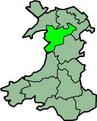 Ancient extent of Merionethshire | |
| Geography | |
| 1831 area | 385,291 acres (1,559.217 km2) |
| 1911/1961 area | 422,372 acres (1,709.279 km2) |
| HQ | Dolgellau |
| Chapman code | MER |
| History | |
| Created | 1284 |
| Succeeded by | Meirionnydd |
| Demography | |
|---|---|
| 1831 population - 1831 density |
35,315[1] 0.1/acre |
| 1911 population - 1911 density |
45,565 0.1/acre |
| 1961 population - 1961 density |
38,310 0.1/acre |
| Politics | |
| Governance | Merionethshire County Council (1889-1974) |
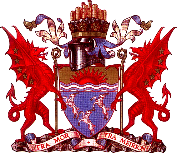 Coat of arms of Merionethshire County Council | |
Merionethshire (Welsh: Meirionnydd, Sir Feirionnydd) is one of thirteen historic counties of Wales, a vice county and a former administrative county.
The administrative county of Merioneth, created under the Local Government Act 1888, was abolished under the Local Government Act 1972 on April 1, 1974. The bulk formed the Meirionnydd district in the new county of Gwynedd, with a small area in the north east, Edeirnion Rural District, becoming part of the Glyndŵr district of Clwyd. As a result of the Local Government (Wales) Act 1994, which came into force in 1996, the Glyndŵr area lies within the county of Denbighshire, with the rest of the old county remaining in Gwynedd.
The administrative entity of Merionethshire was briefly revived in 1996, when the unitary area of Caernarfonshire and Merionethshire was created. It was, however, renamed Gwynedd almost immediately. [2]
The spelling of the Welsh name in standard modern orthography is Meirionnydd (for the geographical area) or Sir Feirionnydd (for the county), with a double <nn>, but the variant with a single <n> is sometimes found in older works.[3][4]
Geography[]
Merionethshire is a maritime county, bounded to the north by Caernarfonshire, to the east by Denbighshire, to the south by Montgomeryshire and Cardiganshire, and to the west by Cardigan Bay. With a total area of 1,731 km², it is one of the more sparsely populated counties in Great Britain. The Merioneth area is also one of the strongest Welsh-speaking parts of Wales. The coastline consists alternately of cliffs and stretches of sand and the area generally is the most mountainous in Wales; a large part of the Snowdonia National Park lies within it. The greatest heights are Aran Fawddwy 905 m (2,970 ft) and Cadair Idris 893 m (2,929 ft). The chief rivers are the Dwyryd, the Mawddach and the Dyfi. Waterfalls and small lakes are numerous, the largest being Bala Lake (4 miles long and 1-mile (1.6 km) broad).
History[]
The county was formed in 1284 under the terms of the Statute of Rhuddlan from the Cantrefi of:
- Meirionnydd
- Dunoding (but only the larger Ardudwy commote)
- Penllyn and the Lordship of Dinmael
Merioneth was an important part of the Welsh slate industry in the nineteenth and twentieth centuries, with major quarrying centres at Blaenau Ffestiniog in the north of the county and Corris in the south.
Main Towns[]
The main towns are
- Bala
- Barmouth
- Blaenau Ffestiniog
- Corwen
- Dolgellau
- Ffestiniog
- Tywyn
The main industries today are agriculture, forestry and tourism.
Places of special interest (with grid reference)[]
- Cadair Idris (SH711130)
- Castell y Bere (SH667085)
- Cymer Abbey (SH721195)
- Harlech Castle (SH5731)
- Portmeirion Italianate village (SH589372)
- Rhug Chapel (SJ063439)
- Tomen-y-mur Roman Fort (SH7038)
- Ffestiniog Railway (SH6946)
- Corris Railway (SH7507)
- Talyllyn Railway (SH5800)
- Fairbourne Railway (SH6112)
References[]
- ^ Vision of Britain - 1831 Census
- ^ "The County of Gwynedd (Electoral Changes) Order 2002, Welsh Statutory Instrument 2002 No. 3274 (W.312)". Office of Public Sector Information. 2002. http://www.opsi.gov.uk/legislation/wales/wsi2002/20023274e.htm. Retrieved 2008-07-27.
- ^ Double 'nn' is found in the title of a number of Welsh-language books, e.g. Crwydro Meirionnydd, a companion to the area by T. I. Ellis (Llandybie, 1954), and the county atlas published by the old county council (Atlas Merionnydd, Y Bala, 1972).
- ^ For the single 'n' variant see, for example, Melville Richards, Welsh Administrative and Territorial Units. University of Wales Press, Cardiff 1969.
| ||||||||||||||||||||||||||||||||||
| This page uses content from the English language Wikipedia. The original content was at Merionethshire. The list of authors can be seen in the page history. As with this Familypedia wiki, the content of Wikipedia is available under the Creative Commons License. |