| City of Merced | |||
|---|---|---|---|
| — City and county seat — | |||
 |
|||
|
|||
 |
|||
 <div style="position: absolute; top: Expression error: Missing operand for *.%; left: 212.7%; height: 0; width: 0; margin: 0; padding: 0;">
City of Merced |
|||
| Country | United States | ||
| State | California | ||
| County | Merced County | ||
| Incorporated | April 1, 1889[1] | ||
| Government | |||
| • Type | Council–manager[2] | ||
| • Mayor | Mike Murphy (R)[3] | ||
| • State senator | Anthony Cannella (R)[4] | ||
| • Assemblymember | Adam Gray (D)[4] | ||
| • U. S. rep. | Jim Costa (D)[5] | ||
| Area[6] | |||
| • Total | 23.23 sq mi (60.16 km2) | ||
| • Land | 23.23 sq mi (60.16 km2) | ||
| • Water | 0.00 sq mi (0.00 km2) 0% | ||
| Elevation[7] | 171 ft (52 m) | ||
| Population (2010)[8] | |||
| • Total | 78,958 | ||
| • Estimate (2018)[9] | 86,750 | ||
| • Density | 3,556.10/sq mi (1,372.99/km2) | ||
| Time zone | Pacific (UTC−8) | ||
| • Summer (DST) | PDT (UTC−7) | ||
| ZIP codes | 95340–95344, 95348 | ||
| Area code | 209 | ||
| FIPS code | 06-46898 | ||
| GNIS feature IDs | 1659751, 2411080 | ||
| Website | cityofmerced.org | ||


Merced /mɜːrˈsɛd/ (Spanish for "Mercy") is a city in, and the county seat of, Merced County, California, United States, in the San Joaquin Valley. As of 2014, the city had a population of 81,743.[8] Incorporated on April 1, 1889, Merced is a charter city that operates under a council-manager government. It is named after the Merced River, which flows nearby.
Merced, known as the "Gateway to Yosemite," is less than two hours by automobile from Yosemite National Park to the east and Monterey Bay, the Pacific Ocean, and multiple beaches to the west. The community is served by the passenger rail service Amtrak, a minor, heavily subsidized airline through Merced Regional Airport, and three bus lines. It is approximately 110 miles (180 km) from Sacramento, 130 miles (210 km) from San Francisco, 45 miles (72 km) from Fresno, and 270 miles (430 km) from Los Angeles.
In 2005, the city became home to the 10th University of California campus, University of California, Merced (UC Merced), the first research university built in the U.S. in the 21st century.[10]
Community[]
Since 2005, Merced has been home to University of California, Merced. Current recreational opportunities in the city include Applegate Park and zoo, Bear and Black Rascal Creeks and their bike trails, a skate park located in Applegate, Playhouse Merced, a live-stage theater downtown, two first-run movie theaters, The Mainzer Theater which is known for its historic and architectural value, the County Courthouse Museum circa 1889, the Merced Multicultural Arts Center and the County Library. Though still growing, Merced has several shopping areas including the Merced Mall, anchored by Target, Sears, JCPenney and Kohl's, a strip mall located on the city's northwest side which includes Best Buy, Barnes & Noble, Lowe's, Wal-Mart, and several restaurants. Merced's Main Street contains several restaurants, a movie theater, and other assorted shops.
Also within a short distance from the city limits are the Castle Air Museum, Lake Yosemite, and Merced Falls. Merced is also the headquarters of Malibu Boats, a manufacturer of inboard boats. The city of Merced along with its surrounding cities are serviced by the Merced Sun-Star and the Merced County Times. The Sun-Star daily newspaper has a circulation of over 20,000 in the Merced area and the Times weekly newspaper has a circulation of over 5,000.

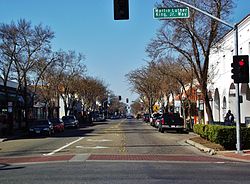
Main Street in Merced California
Homes at the median level in Merced had lost 62% of their value from the second quarter of 2006, when they peaked at $336,743, the biggest drop anywhere in the country, according to data provided to Forbes by Local Market Monitor, a Cary, North-Carolina-based real-estate research firm. Home prices have since rebounded, with the median sale price in April 2018 at $247,000.[11] Earlier, home building and buying grew exponentially in Merced, but the metro area went to a 14.2% unemployment rate in December 2013. Having since recovered to a rate of 8.7% in April 2018, it is still above the national and state unemployment averages. However, some efforts have been directed towards diversifying its economy and are showing a lowering trend in the overall unemployment rate,[12] according to the Bureau of Labor Statistics.
During the Great Recession Merced suffered one of the greatest property price collapses in the country and house prices at the end of 2009 had fallen to 1998 levels, according to Zillow, making housing affordable compared to many other California locations. Merced's population has grown faster than the state average since 1980. Over the past nine years, the annualized growth rate is about 3.4%. This rapid expansion of population has stimulated significant retail growth since 1992. Several major retail chain stores have entered Merced, adding over 750,000 square feet (70,000 m2) of new retail space in that time and increasing the City's sales tax receipts by over $500,000 annually. On 6/19/2018, Merced appeared on the MSN.com portal page as one of the 50 worst cities in the USA
The economy has traditionally relied upon agribusiness and upon the presence of Castle Air Force Base. Over the past twenty years, more diversified industry has entered the area, including printing, fiberglass boat building, warehousing and distribution, and packaging industries.
In September 1995, Castle Air Force Base closed after phasing down over the previous three years. This affected residential real estate and some sectors of the retail and service economies but overall retail continued to increase. No significant increase in unemployment was noted. Re-use of the former base is actively proceeding. Industrial development is increasing in the area.
Since 1992, more than 400,000 square feet (37,000 m2) of new industrial activity has started. In May 1995, Merced was selected as the home of the next University of California campus. UC Merced opened with its first 1,000 students in September 2005. Local planning is underway to accommodate campus development, which will eventually accommodate about 25,000 students.
History[]
The first Merced post office opened in 1870.[13] Merced incorporated in 1889[13] and now operates under the Council-Manager form of government.

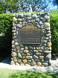
A plaque marking the site of the Merced Assembly Center
During World War II, the Merced County fairgrounds were the site of a temporary "assembly center" where Japanese Americans were detained after being removed from their West Coast homes under Executive Order 9066. 4,669 men, women and children from central California (with most coming from Merced County) were confined in the Merced Assembly Center from May 6 to September 15, 1942, when they were transferred to the more permanent Granada internment camp in Colorado.[14]
Transportation[]
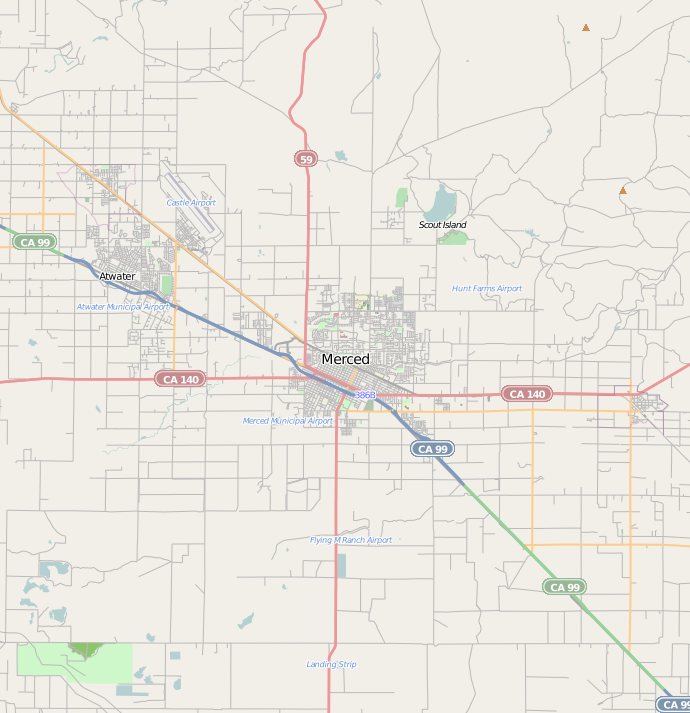

Major highways near Merced
Major highways[]
 State Route 59
- State Route 99
- State Route 140
Air[]
- Merced Regional Airport. Passenger service provided by Boutique Air.
- Castle Airport in nearby Atwater, California.
Bus[]
- Greyhound, Intercalifornias, TUFESA and Fronteras del Norte serve Merced.
- YARTS provides scheduled service into Yosemite National Park.
- Merced County Transit, "The Bus", operates both regularly scheduled fixed route bus service and Dial-A-Ride (demand response) transportation services throughout Merced County.
- CatTracks[15] is UC Merced's bus service, which connects students, staff and faculty at the university to off-campus apartments, the off-campus Castle facilities, local amenities, the Amtrak station, and the downtown area.
Rail[]
- Amtrak San Joaquin provides passenger service.[16]


Map of proposed route, also including the proposed Desert Xpress to Las Vegas
High-speed rail[]
Officials of the California High-Speed Rail Authority say a flat, straight stretch through the San Joaquin Valley connecting Merced and Bakersfield will likely be the first completed. Regional Manager Thomas Tracy told the Visalia City Council that the 800-mile (1,300 km) project will be built in eight phases. The first segment, due by 2015, would stretch from Bakersfield to Merced on an initial run from San Diego to Sacramento. At its full 220 mph speed, the normally three-hour car trip from Merced to Bakersfield would take 45 minutes.
Sample trips in the California High Speed rail would include:
- Merced to Sacramento – 43 minutes
- Merced to San Jose – 45 minutes
- Merced to San Francisco – 1 hour and 15 minutes
- Merced to Los Angeles – 1 hour and 40 minutes
Geography and geology[]


Merced County countryside
Merced is located at .[7] According to the United States Census Bureau, the city has a total area of 23.3 square miles (60 km2).
Merced is approximately 110 miles (180 km) southeast of San Francisco and 310 miles (500 km) northwest of Los Angeles.[17]
A major groundwater plume containing the contaminant PCE was discovered in Merced in 1987.[18] Subsequently, drilling of new water wells was severely restricted.[19]
Climate[]
Merced has a semi-arid climate, featuring very hot, dry summers and mild, wet winters.[20] Average January temperatures are a maximum of 55.0 °F and a minimum of 36.0 °F. Average July temperatures are a maximum of 97.1 °F and a minimum of 60.9 °F. There are an average of 98.7 days with highs of 90 °F (32 °C) or higher and an average of 33.6 days with lows of 32 °F (0 °C) or lower. The record highest temperature of 114 °F was recorded on July 24, 1902, and August 8, 1905. The record lowest temperature of 13 °F was recorded on January 13, 2007.
Most of the rainfall occurs during the winter and averages 12.21 inches (310 mm) annually. There are an average of 48 days annually with measurable precipitation. The wettest year was 1998 with 21.66 inches (550 mm) and the driest year was 1947 with 5.50 inches (140 mm). The most rainfall in one month was 8.00 inches (203 mm) in January 1909. The most rainfall in 24 hours was 2.20 inches (56 mm), which occurred on January 30, 1911, and March 9, 1911. Although snow is relatively rare in Merced, averaging only 0.6-inch (15 mm) annually, the city's proximity to the Sierra Nevada has resulted in some instances of remarkably heavy snowfall. The record 24-hour snowfall was 13.9 inches (35 cm) on February 16, 1946. The most snowfall in one month was 39.0 inches (99 cm) in December 1906.[21]
| Climate data for Merced, California (1899 - 2016) | |||||||||||||
|---|---|---|---|---|---|---|---|---|---|---|---|---|---|
| Month | Jan | Feb | Mar | Apr | May | Jun | Jul | Aug | Sep | Oct | Nov | Dec | Year |
| Record high °F (°C) | 77 (25) |
84 (29) |
88 (31) |
98 (37) |
109 (43) |
111 (44) |
114 (46) |
114 (46) |
110 (43) |
102 (39) |
91 (33) |
76 (24) |
114 (46) |
| Average high °F (°C) | 54.9 (12.7) |
61.6 (16.4) |
67.2 (19.6) |
74.3 (23.5) |
82.6 (28.1) |
90.8 (32.7) |
97.1 (36.2) |
95.3 (35.2) |
90.0 (32.2) |
79.8 (26.6) |
66.2 (19.0) |
55.7 (13.2) |
76.3 (24.6) |
| Average low °F (°C) | 36.0 (2.2) |
38.7 (3.7) |
41.2 (5.1) |
44.9 (7.2) |
50.6 (10.3) |
56.4 (13.6) |
60.9 (16.1) |
58.9 (14.9) |
54.8 (12.7) |
47.2 (8.4) |
39.6 (4.2) |
35.6 (2.0) |
47.1 (8.4) |
| Record low °F (°C) | 13 (−11) |
20 (−7) |
20 (−7) |
22 (−6) |
30 (−1) |
37 (3) |
39 (4) |
35 (2) |
32 (0) |
28 (−2) |
21 (−6) |
15 (−9) |
13 (−11) |
| Precipitation inches (mm) | 2.46 (62.5) |
2.17 (55.1) |
1.96 (49.8) |
1.09 (27.7) |
0.44 (11.2) |
0.10 (2.5) |
0.01 (0.3) |
0.02 (0.5) |
0.15 (3.8) |
0.60 (15.2) |
1.37 (34.8) |
1.89 (48) |
12.27 (311.7) |
| Source: Western Regional Climate Center [21] | |||||||||||||
Agriculture[]
Merced is ranked as the fifth-top producing county in California. In 2016, Merced County generated more than 3.4 billion dollars in total value of production. The top five commodities from 2016 in Merced are:[22]
| Crops | $ Amount (1,000) | Ranking in CA | % of State Total |
|---|---|---|---|
| Milk | 858,441 | 2nd | 15.2 |
| Almonds | 578,581 | 4th | 9.3 |
| Chickens | 381,036 | 2nd | 34.8 |
| Cattle & Calves | 296,508 | 5th | 8.1 |
| Sweet Potatoes | 232,399 | 1st | 88.5 |
Economy[]
Top employers[]
According to the city's 2010 Comprehensive Annual Financial Report,[23] the top employers in the city are:
| # | Employer | # of Employees |
|---|---|---|
| 1 | County of Merced | 2,028 |
| 2 | University of California, Merced | 1,602 |
| 3 | Mercy Medical Center Merced | 1,200 |
| 4 | Merced City School District | 1,141 |
| 5 | Merced Union High School District | 949 |
| 6 | Merced College | 900 |
| 7 | City of Merced | 584 |
| 8 | Quad/Graphics | 564 |
| 9 | AT&T Mobility | 500 |
| 10 | Wal-Mart | 311 |
In the summer of 2014, the Castle Commerce Center's call center closed, subtracting 400 jobs from AT&T's share of employment.[24][25]
Education[]


Science and Engineering 1 building at University of California, Merced
The Merced area has access to several institutions of higher learning. Within a one-hour radius, close to 100,000 students attend colleges and universities, including: University of California, Merced, California State University, Stanislaus, California State University, Fresno and the University of the Pacific. Engineering, Business, and Nursing are some of the most studied subjects at these campuses. The University of California, Merced campus opened in late 2005 northeast of the city limits. UC Merced enrolled about 7,967 students during the 2017-2018 academic year.[26] Merced is served by the Merced Union High School District and three major public high school campuses, Merced High School, Golden Valley High School, and El Capitan High School as well as a few smaller campuses offering alternative education. Merced has one community college, Merced College, which has an enrollment of more than 10,884 students as of Spring 2017.[27]
In May 2008, the UC Board of Regents endorsed continued planning for a UC Merced School of Medicine.
Health[]


Mercy Medical Center, Merced California
A 2016 Community Health Assesment prepared by the Merced County Department of Public Health (MCDPH), determined that top health topics that affect Merced and Merced county are income, education, and employment; heart disease and stroke; diabetes; access to health care; and drug and alcohol abuse. In 2017 the MCDPH published the Merced County Community Health Improvement Plan in an effort to "address health disparities and to promote health equity with the goal of health and wellness for all county residents."
Mercy Medical Center Merced is located in Merced.
Demographics[]
| Historical populations | |||
|---|---|---|---|
| Census | Pop. | %± | |
| 1880 | 1,446 | ||
| 1890 | 2,009 | 38.9% | |
| 1900 | 1,969 | −2.0% | |
| 1910 | 3,102 | 57.5% | |
| 1920 | 3,974 | 28.1% | |
| 1930 | 7,066 | 77.8% | |
| 1940 | 10,135 | 43.4% | |
| 1950 | 15,278 | 50.7% | |
| 1960 | 20,068 | 31.4% | |
| 1970 | 22,670 | 13.0% | |
| 1980 | 36,423 | 60.7% | |
| 1990 | 56,216 | 54.3% | |
| 2000 | 63,893 | 13.7% | |
| 2010 | 78,958 | 23.6% | |
| Est. 2018 | 86,750 | [9] | 35.8% |
| U.S. Decennial Census[28] | |||
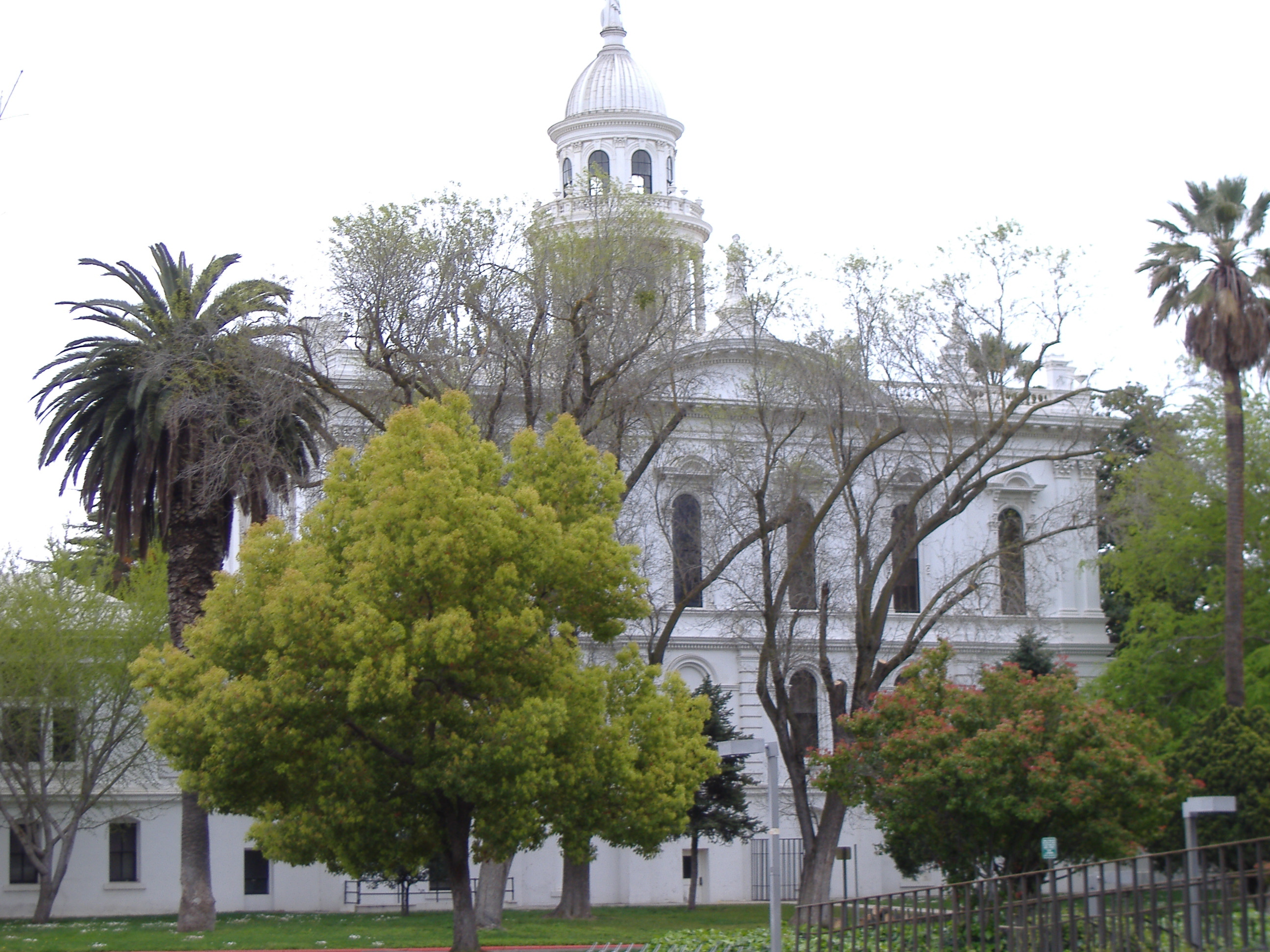

Historic County Courthouse, now serving as a museum
2010[]
The 2010 United States Census[29] reported that Merced had a population of 78,959 . The population density was 3,386.4 people per square mile. (1,307.5/km²). The racial makeup of Merced was 41,177 (52.1%) White, 4,958 (6.3%) African American, 1,153 (1.5%) Native American, 9,342 (11.8%) Asian, 174 (0.2%) Pacific Islander, 17,804 (22.5%) from other races, and 4,350 (5.5%) from two or more races. Hispanic or Latino of any race were 39,140 persons (49.6%).
The Census reported that 77,878 people (98.6% of the population) lived in households, 492 (0.6%) lived in non-institutionalized group quarters, and 588 (0.7%) were institutionalized.
There were 24,899 households, out of which 11,484 (46.1%) had children under the age of 18 living in them, 10,958 (44.0%) were opposite-sex married couples living together, 4,921 (19.8%) had a female householder with no husband present, 1,941 (7.8%) had a male householder with no wife present. There were 2,156 (8.7%) unmarried opposite-sex partnerships, and 167 (0.7%) same-sex married couples or partnerships. 5,356 households (21.5%) were made up of individuals and 1,823 (7.3%) had someone living alone who was 65 years of age or older. The average household size was 3.13. There were 17,820 families (71.6% of all households); the average family size was 3.65.
The population was spread out with 25,091 people (31.8%) under the age of 18, 10,475 people (13.3%) aged 18 to 24, 20,986 people (26.6%) aged 25 to 44, 15,484 people (19.6%) aged 45 to 64, and 6,922 people (8.8%) who were 65 years of age or older. The median age was 28.1 years. For every 100 females, there were 96.3 males. For every 100 females age 18 and over, there were 93.6 males.
There were 27,446 housing units at an average density of 1,177.1 per square mile (454.5/km²), of which 10,637 (42.7%) were owner-occupied, and 14,262 (57.3%) were occupied by renters. The homeowner vacancy rate was 3.5%; the rental vacancy rate was 8.5%. 31,690 people (40.1% of the population) lived in owner-occupied housing units and 46,188 people (58.5%) lived in rental housing units.
2000[]
As of the census[30] of 2000,[31] there were 63,893 people, 20,435 households, and 14,631 families residing in the city. The population density was 3,216.7 people per square mile (1,242.2/km²). There were 21,532 housing units at an average density of 1,084.0 per square mile (418.6/km²). The racial makeup of the city was 57.4% White, 6.3% African American, 1.3% Native American, 12.4% Asian (mostly Hmong), 0.2% Pacific Islander, 23.2% from other races, and 5.2% from two or more races. Hispanic or Latino of any race were 26.4% of the population.
There were 20,435 households, out of which 42.9% had children under the age of 18 living with them, 47.2% contained married couples living together, 18.2% had a female householder with no husband present, and 28.4% were "nonfamilies." 22.6% of all households were made up of individuals and 8.5% had someone living alone who was 65 years of age or older. The average household size was 3.06 and the average family size was 3.62.
In the city, the population was spread out, with 34.7% under the age of 18, 11.4% from 18 to 24, 27.4% from 25 to 44, 17.1% from 45 to 64, and 9.4% who were 65 years of age or older. The median age was 28 years. For every 100 females, there were 95.6 males. For every 100 females age 18 and over, there were 92.3 males.
The median income for a household in the city was $30,429, and the median income for a family was $32,470. Males had a median income of $31,725 versus $24,492 for females. The per capita income for the city was $13,115. About 22.4% of families and 27.9% of the population were below the poverty line, including 36.9% of those under age 18 and 10.1% of those age 65 or over.
Hmong community[]
Escaping persecution from Communist forces after the Laotian Civil War, Hmong refugees from Laos moved to the United States in the 1970s and '80s, first settling in Merced and other areas in the Central Valley of California.[32][33] The Hmong could not initially take part in farming like they had expected, as the land was owned by other people.[33] They could not get high end agricultural jobs because they did not speak sufficient English and Mexican migrants already held low end agricultural jobs. As such, a great many of Merced's Hmong collected social services and Hmong gangs arose, prompting other residents to perceive them as being the cause of economic troubles.[34] As the Hmong settlement matured and the Hmong children gained English language skills, the town's overall attitude began to be more accepting of the Hmong community.[33]
This acceptance is reflected in various services provided to the Hmong community. This includes the Merced Lao Family Community Inc., a nonprofit organization that provides social services to Hmong people,[35] the Merced Department of Public Health's MATCH (Multidisciplinary Approach to Cross-Cultural Health) program, intending to draw Hmong patients into the health care system,[32][36] a body of Hmong-speaking faculty and paraprofessionals (including college classes on Hmong culture and language),[35][37] and media outlets for the Hmong community—cable television channel Channel 11 broadcasts programming to the Hmong community twice per week and radio station KBIF 900 AM airs programming oriented towards Hmong people.[35]
While Merced has historically had a proportionally large portion of Hmong (in 1997, 12,000 of Merced's 61,000 residents were Hmong[34]), demographic shifts have reduced this. The Personal Responsibility and Work Opportunity Act of 1996 prompted a move of some Hmong to Minnesota, North Carolina, and Wisconsin. More recently, many Hmong have gone to Alaska to work in crabbing and fishing industries that require little proficiency in English.[33]
Racial demographics[]
In 2010, Latinos became a majority population in Merced and Merced County as the agricultural industry brought in migrant farm laborers. The area's affordable housing prices attracted both Latino and Asian immigrants. Merced has large Asian-American (e.g. Hmong, followed by Chinese, Vietnamese, Laotian, Cambodian, Filipino, Thai, Korean[38] and Asian Indian) populations relative to the city and county's population size.[31]
Government[]
In the California State Legislature, Merced is in the 12th Senate District, represented by Republican Anthony Cannella, and in the 21st Assembly District, represented by Democrat Adam Gray.[4]
In the United States House of Representatives, Merced is in California's 16th congressional district, represented by Democrat Jim Costa.[39]
Sister cities[]
Merced has two sister cities, as designated by Sister Cities International:
- Albury, Australia
- Somoto, Nicaragua
Notable people[]
- Jerry Garvin, MLB pitcher for the Toronto Blue Jays
- Lloyd Allen, MLB pitcher
- Ray Allen, NBA player
- Jeff Ball, MLB player
- Summer Bartholomew, Miss California USA 1975, Miss USA 1975
- Michael Basinger, NFL player for the Green Bay Packers
- Bruce Bowen, NBA player for the San Antonio Spurs
- Jim Brewer, MLB pitcher
- Tom Cable, NFL player and coach, former head coach of Oakland Raiders
- Diana Serra Cary, child actress known as "Baby Peggy", writer, silent film historian and advocate for child actors
- Margaret Dingeldein, member of women's US Olympic water polo team at 2004 Athens Olympics
- Tommy Duncan, singer with Bob Wills and Texas Playboys, buried in Merced
- Marvin Eastman, mixed martial arts fighter
- Doug Fister, MLB player for the Washington Nationals
- John Flinn, MLB player for the Baltimore Orioles and Milwaukee Brewers
- Dylan Floro, MLB player for the Los Angeles Dodgers
- Brian Fuentes, MLB player for six teams
- Katie Gallagher, finalist on reality television show Survivor: Palau
- Dave Henderson, MLB player for five teams
- Salar Kamangar, Former CEO of YouTube, founding member of Google's product team
- Philip H. Lathrop, Emmy-winning, Oscar-nominated cinematographer
- Janet Leigh, actress, star of Alfred Hitchcock film Psycho
- Gerald Madkins, NBA player and executive
- Blas Minor, MLB pitcher
- Bill Mooneyham, MLB player for the Oakland Athletics
- Dwayne Murphy, MLB player for the Oakland Athletics
- David Odell, screenwriter
- Charles Ogletree, Harvard Law School professor, and public intellectual
- Curtis Partch, MLB player for the Cincinnati Reds
- Chris Pritchett, MLB player
- Peter Rojas, Founder of Engadget[40]
- Dusty Ryan, MLB player for the New York Mets
- Daniel Silva, best-selling novelist[41]
- Tony Slaton, NFL player for the Los Angeles Rams and Dallas Cowboys
- Cary Stayner, serial killer
- Steven Stayner, kidnap victim[42]
- Rowena Granice Steele (1824–1901), American performer, editor, publisher
- Joyce Sumbi (1935-2010), African-American librarian
- Thad Tillotson, MLB player for the New York Yankees
- Rick Williams, MLB pitcher for the Houston Astros[43]
Sports[]
- UC Merced Bobcats: softball and other athletic programs,.[44] Merced High School and Golden Valley High School sponsor athletics as well.[45]
Merced has a history of minor league baseball including the California League Merced Bears (1940s)[46] and Atwater Angels (1970s) in nearby Atwater, California. There were the defunct Merced Black Bears of the Horizon Air Summer Series and the current Atwater Aviators of the Golden State Collegiate Baseball League.[47]
See also[]
References and notes[]
- ^ "California Cities by Incorporation Date" (Word). California Association of Local Agency Formation Commissions. Archived from the original on October 17, 2013. https://web.archive.org/web/20131017052413/http://www.calafco.org/docs/Cities_by_incorp_date.doc. Retrieved August 25, 2014.
- ^ "Merced, CA Code of Ordinances [codes - Sec. 300. - Form of government"]. Municode. https://www.municode.com/library/ca/merced/codes/code_of_ordinances?nodeId=THCH_ARTIIIFOGO_S300FOGO. Retrieved February 4, 2015.
- ^ "Merced City Council". City of Merced, CA. http://www.cityofmerced.org/depts/city_council/default.asp. Retrieved 2014-09-16.
- ^ a b c "Statewide Database". UC Regents. http://statewidedatabase.org/gis/gis2011/index_2011.html. Retrieved November 21, 2014.
- ^ "California's 16th Congressional District - Representatives & District Map". Civic Impulse, LLC. http://www.govtrack.us/congress/members/CA/16.
- ^ "2016 U.S. Gazetteer Files". United States Census Bureau. https://www2.census.gov/geo/docs/maps-data/data/gazetteer/2016_Gazetteer/2016_gaz_place_06.txt. Retrieved Jun 28, 2017.
- ^ a b "Merced". Geographic Names Information System, U.S. Geological Survey. http://geonames.usgs.gov/pls/gnispublic/f?p=gnispq:3:::NO::P3_FID:1659751. Retrieved February 24, 2015.
- ^ a b "American FactFinder - Results". United States Census Bureau. http://factfinder.census.gov/bkmk/table/1.0/en/PEP/2014/PEPANNRSIP.US12A. Retrieved May 22, 2015.
- ^ a b "E-1 Population Estimates for Cities, Counties, and the State — January 1, 2017 and 2018". http://dof.ca.gov/Forecasting/Demographics/Estimates/E-1/. Retrieved September 28, 2018.
- ^ "UC Merced – Mission Statement". Archived from the original on May 23, 2007. https://web.archive.org/web/20070523060140/http://www.ucmerced.edu/about_ucmerced/mission.asp. Retrieved February 14, 2019.
- ^ "Merced, CA Housing Market". Realtor.com. April 17, 2018. http://www.realtor.com/local/Merced_CA. Retrieved May 31, 2018.
- ^ "Merced, CA Economy at a Glance". Bureau of Labor Statistics. April 15, 2018. http://www.bls.gov/eag/eag.ca_merced_msa.htm. Retrieved May 31, 2018.
- ^ a b Durham, David L. (1998). California's Geographic Names: A Gazetteer of Historic and Modern Names of the State. Quill Driver Books. p. 801. ISBN 9781884995149.
- ^ Iwata, Adrienne. "Merced (detention facility)" Densho Encyclopedia (accessed 17 Jun 2014).
- ^ "Home | CatTracks" (in en). http://cattracks.ucmerced.edu/.
- ^ "Merced's Amtrak station". http://www.amtrak.com/servlet/ContentServer?c=am2Station&pagename=am%2Fam2Station%2FStation_Page&p=1237405732508&cid=1229726269596. Retrieved February 14, 2019.
- ^ "History of Merced." City of Merced. Retrieved on September 18, 2010.
- ^ Paul M. Santi1, John E. McCray2 and Jamie L. Martens, Hydrogeology Journal, Issue Volume 14, Numbers 1–2, January, 2006, Springer Berlin /Heidelberg
- ^ Environmental Site Assessment for proposed development, Merced, California, Earth Metrics Inc, October 17, 1989
- ^ "Merced, California Köppen Climate Classification (Weatherbase)". http://www.weatherbase.com/weather/weather-summary.php3?s=18427&cityname=Merced,+California,+United+States+of+America&units=. Retrieved February 14, 2019.
- ^ a b "MERCED AP, CALIFORNIA (045532) - Period of Record General Climate Summary. Period of Record : 06/01/1899 to 06/09/2016". Western Regional Climate Center. https://wrcc.dri.edu/cgi-bin/cliMAIN.pl?ca5532. Retrieved September 2, 2017.
- ^ "California Agriculture Statistics Review 2016-2017". https://www.cdfa.ca.gov/Statistics/PDFs/2016-17AgReport.pdf.
- ^ City of Merced, California Comprehensive Annual Financial Report, for the Year ended June 30, 2010 Retrieved 2010-09-24
- ^ [1].
- ^ "Archived copy". Archived from the original on December 6, 2014. https://web.archive.org/web/20141206001403/http://costa.house.gov/index.php/2014-press-releases/1044-costa-outraged-at-at-t-call-center-closure. Retrieved 2014-11-11.
- ^ "Fast Facts 2018-19 | UC Merced". https://www.ucmerced.edu/fast-facts. Retrieved February 14, 2019.
- ^ "Enrollment Status Summary". http://datamart.cccco.edu/Students/Enrollment_Status.aspx. Retrieved 11 February 2018.
- ^ "Census of Population and Housing". Census.gov. https://www.census.gov/prod/www/decennial.html. Retrieved June 4, 2015.
- ^ "2010 Census Interactive Population Search: CA - Merced city". U.S. Census Bureau. https://www.census.gov/2010census/popmap/ipmtext.php?fl=06:0646898. Retrieved July 12, 2014.
- ^ "American FactFinder". United States Census Bureau. http://factfinder2.census.gov. Retrieved 2008-01-31.
- ^ a b "Archived copy". Archived from the original on August 24, 2012. https://www.webcitation.org/6AA13CtiR?url=http://quickfacts.census.gov/qfd/states/06/0646898.html. Retrieved 2012-08-24.
- ^ a b Warner, Miriam E; Mochel, Marilyn (1998), "The Hmong and Health Care in Merced, California", Hmong Studies Journal 2 (2): 30, http://www.hmongstudies.com/HSJ-v2n2_Warner.pdf, retrieved November 28, 2010
- ^ a b c d Reiter, Carol. "Hmong seeking life in Merced, Ca Archived July 16, 2011, at the Wayback Machine." Merced Sun-Star at Suab Hmong Radio. January 29, 2008. Retrieved on September 20, 2010.
- ^ a b Fadiman, Anne (1997), The Spirit Catches You and You Fall Down, Farrar, Straus and Giroux
- ^ a b c Withers, Andrea C. (2004), "Hmong Language and Cultural Maintenance in Merced, California", Bilingual Research Journal 28 (3): 299–318, doi:10.1080/15235882.2004.10162624, http://www.eric.ed.gov/ERICWebPortal/detail?accno=EJ724693
- ^ Anderson, Barbara. "Merced's Mercy Medical opens its door to Hmong shamans." The Modesto Bee. Monday October 19, 2009. Retrieved on November 29, 2010.
- ^ "MERCED COLLEGE OFFERING HMONG LANGUAGE COURSE." Fresno Bee. December 10, 1987. Retrieved on November 29, 2010.
- ^ "Korean Presbyterian church in Merced". http://stat.pcanet.org/ac/directory/directory.cfm.
- ^ "California's 16th Congressional District - Representatives & District Map". Civic Impulse, LLC. http://www.govtrack.us/congress/members/CA/16. Retrieved October 1, 2014.
- ^ "Engadget reader meetup in Merced, CA on for June 10th". https://www.engadget.com/2006/05/25/engadget-reader-meetup-in-merced-ca-on-for-june-10th/. Retrieved February 14, 2019.
- ^ Novelist takes on Vatican secrecy with new spy thriller Archived February 17, 2009, at the Wayback Machine
- ^ Peterson, David (March 21, 1980). "Kidnap victim reunites with 'mystery woman'". St. Petersburg Times. United Press International. https://news.google.com/newspapers?nid=888&dat=19800321&id=YgMMAAAAIBAJ&sjid=JFoDAAAAIBAJ&pg=4706,5549981. Retrieved September 15, 2009.
- ^ "Rick Williams Stats, Fantasy & News". https://www.mlb.com/player/rick-williams-124334. Retrieved February 14, 2019.
- ^ "University of California, Merced Athletics". http://www.ucmercedbobcats.com/. Retrieved February 14, 2019.
- ^ "Archived copy". Archived from the original on October 7, 2013. https://web.archive.org/web/20131007005215/http://www.muhsd.k12.ca.us/Domain/48. Retrieved 2013-10-05.
- ^ "1941 Merced Bears Statistics". https://www.baseball-reference.com/register/team.cgi. Retrieved February 14, 2019.
- ^ http://pointstreaksites.com/view/goldenstatecollegiatebaseballleague/teams-397/atwater-aviators
External links[]
| Wikivoyage has a travel guide for Merced. |
- [http:// Official website]
- UC Merced
- The Merced Sun-Star
- The Merced County Times
| ||||||||||||||||||||||||||
| |||||||||||||||||

| |||||||||||
| ||||||||||||||||||||||||||||||||