m (wp xfer) |
Tag: Visual edit |
||
| (8 intermediate revisions by 5 users not shown) | |||
| Line 1: | Line 1: | ||
| − | {{ |
+ | {{About|the U.S. state}} |
{{Infobox U.S. state |
{{Infobox U.S. state |
||
| Name = Massachusetts |
| Name = Massachusetts |
||
| Fullname = Commonwealth of Massachusetts |
| Fullname = Commonwealth of Massachusetts |
||
| Flag = Flag_of_Massachusetts.svg |
| Flag = Flag_of_Massachusetts.svg |
||
| − | | Flaglink = |
+ | | Flaglink = [[Flag of Massachusetts|Flag]] |
| − | | Seal = |
+ | | Seal = Seal_of_Massachusetts.svg |
| − | | Map = |
+ | | Map = Massachusetts in United States.svg |
| + | | Nickname =The Bay State,<ref name=mass>{{Cite document | url = http://www.netstate.com/states/intro/ma_intro.htm | contribution = Introduction to Massachusetts | title = 50 States | accessdate = November 3, 2012 | publisher = Net state | postscript = <!-- Bot inserted parameter. Either remove it; or change its value to "." for the cite to end in a ".", as necessary. -->{{inconsistent citations}}}}.</ref> The Old Colony State,<ref>{{Cite document | contribution-url = http://www.britannica.com/EBchecked/topic/368402/Massachusetts | contribution = Massachusetts (state, United States) | title = [[Encyclopædia Britannica]] | edition = online | postscript = <!-- Bot inserted parameter. Either remove it; or change its value to "." for the cite to end in a ".", as necessary. -->{{inconsistent citations}}}}.</ref> The Codfish State<ref>{{Cite news | url = http://news.google.com/newspapers?nid=1499&dat=19361018&id=A65QAAAAIBAJ&sjid=ASIEAAAAIBAJ&pg=7015,741245 | title = A Colorful Battle Is Lodge vs. Curley | newspaper = The Milwaukee Journal | date = Oct 18, 1936 | accessdate = November 3, 2012 | quote = One of the Codfish State... | postscript = <!-- Bot inserted parameter. Either remove it; or change its value to "." for the cite to end in a ".", as necessary. -->{{inconsistent citations}}}}.</ref> |
||
| − | | Nickname = Bay State |
||
| + | | Motto = [[Ense petit placidam sub libertate quietem]] ''([[Latin]])''<br><small>By the sword we seek peace, but peace only under liberty</small> |
||
| − | {{wp|List of U.S. state birds|State Bird}} = {{wp|Black-capped Chickadee}} |
||
| + | | MottoEnglish = By the sword she seeks peace under liberty |
||
| − | | Motto = {{wp|Ense petit placidam sub libertate quietem}} |
||
| + | | Former = Province of Massachusetts Bay |
||
| − | (Latin: By the sword she seeks peace under liberty) |
||
| + | | Demonym = Bay Stater (official)<ref>{{cite web| title = Massachusetts General Laws, Chapter 2, Section 35: Designation of citizens of commonwealth|url=http://www.mass.gov/legis/laws/mgl/2-35.htm|publisher=The Commonwealth of Massachusetts| accessdate = February 29, 2008}}</ref> Massachusite (traditional)<ref>{{Cite document | page = 435 | title = Collections | publisher = [[Massachusetts Historical Society]] | place = Boston | year = 1877 | url = http://books.google.com/books?id=rdbnCkXB2RwC | postscript = <!-- Bot inserted parameter. Either remove it; or change its value to "." for the cite to end in a ".", as necessary. -->{{inconsistent citations}}}}.</ref><ref>{{Cite book | last = Jones | first = Thomas | page = 465 | title = History of New York During the Revolutionary War | publisher = [[New York Historical Society]] | editor-first = Edward Floyd | editor-last = DeLancey | place = New York | year = 1879 | url = http://books.google.com/books?id=pbuXATAHXMEC | postscript = <!-- Bot inserted parameter. Either remove it; or change its value to "." for the cite to end in a ".", as necessary. -->{{inconsistent citations}}}}.</ref> Massachusettsian (archaic)<ref>[[wiktionary:Massachusettsian]].</ref> |
||
| − | | Capital = {{wp|Boston, Massachusetts|Boston}} |
||
| − | | |
+ | | Capital = [[Boston]] |
| + | | LargestCity = capital |
||
| − | | LargestMetro = {{wp|Greater Boston}} |
||
| + | | LargestMetro = [[Greater Boston]] |
||
| − | | Governor = {{wp|Deval Patrick}} (D) |
||
| + | | Governor = [[Deval Patrick]] (D) |
||
| − | | Senators = {{wp|Edward Kennedy}} (D)<br>{{wp|John Kerry}} (D) |
||
| + | | Lieutenant Governor = [[Tim Murray]] (D) |
||
| + | | Legislature = [[Massachusetts General Court|General Court]] |
||
| + | | Upperhouse = [[Massachusetts Senate|Senate]] |
||
| + | | Lowerhouse = [[Massachusetts House of Representatives|House of Representatives]] |
||
| + | | Senators = [[Elizabeth Warren]] (D)<br />[[Mo Cowan]] (D) |
||
| + | | Representative=9 Democrats |
||
| PostalAbbreviation = MA |
| PostalAbbreviation = MA |
||
| TradAbbreviation = Mass. |
| TradAbbreviation = Mass. |
||
| − | | OfficialLang = |
+ | | OfficialLang = None |
| − | | AreaRank = |
+ | | AreaRank = 44th |
| − | | TotalAreaUS = 10,555 <!-- |
+ | | TotalAreaUS = 10,555<ref name=2000census/><!--To nearest sqmi., from USCensus web page--> |
| − | | TotalArea = 27,336 <!--conversion to nearest |
+ | | TotalArea = 27,336 <!--conversion to nearest km²--> |
| − | | LandAreaUS = 7,840 |
+ | | LandAreaUS = 7,840 |
| LandArea = 20,306 |
| LandArea = 20,306 |
||
| WaterAreaUS = 2,715 |
| WaterAreaUS = 2,715 |
||
| WaterArea = 7,031 |
| WaterArea = 7,031 |
||
| PCWater = 25.7 <!--calculation: Water area over Total area--> |
| PCWater = 25.7 <!--calculation: Water area over Total area--> |
||
| − | | PopRank = |
+ | | PopRank = 14th |
| + | | 2010Pop = 6,646,144 (2012 est)<ref name=PopEstUS/> |
||
| − | | 2000Pop = 6,349,097 |
||
| + | | DensityRank = 3rd |
||
| − | | 2004Pop(Est.) = 6,416,506 |
||
| + | | 2000DensityUS = 840 |
||
| − | | DensityRank = 3<sup>rd</sup> |
||
| + | | 2000Density = 324 |
||
| − | | 2000DensityUS = 809.8 <!--from USCensus web site, confirmed by calc--> |
||
| + | | MedianHouseholdIncome = $65,401 (2008) |
||
| − | | 2000Density = 312.7 |
||
| + | | IncomeRank = 6th | |
||
| − | | MedianHouseholdIncome = $52,354 | |
||
| + | | AdmittanceOrder = 6th |
||
| − | IncomeRank = 9<sup>th</sup> | |
||
| + | | AdmittanceDate = February 6, 1788 |
||
| − | | AdmittanceOrder = 6<sup>th</sup> |
||
| + | | TimeZone = [[Eastern Time Zone (North America)|Eastern]]: [[Coordinated Universal Time|UTC]][[Eastern Time Zone|-5]]/[[Eastern Daylight Time|-4]] |
||
| − | | AdmittanceDate = {{wp|February 6}}, {{wp|1788}} |
||
| + | | Latitude = 41° 14′ N to 42° 53′ N |
||
| − | | TimeZone = {{wp|Eastern Standard Time Zone|Eastern}}: {{wp|UTC}}-5/{{wp|Daylight saving time|-4}} |
||
| − | | |
+ | | Longitude = 69° 56′ W to 73° 30′ W |
| − | | Longitude = 69° 56′ W to 73° 30′ W |
||
| LengthUS = 113 |
| LengthUS = 113 |
||
| Length = 182 |
| Length = 182 |
||
| WidthUS = 183 |
| WidthUS = 183 |
||
| Width = 295 |
| Width = 295 |
||
| − | | HighestPoint = |
+ | | HighestPoint = [[Mount Greylock]]<ref>{{cite ngs|name=Greylock RM 1 Reset|id=MZ1957}}</ref><ref name=USGS>{{cite web|url = http://egsc.usgs.gov/isb/pubs/booklets/elvadist/elvadist.html|title=Elevations and Distances in the United States|publisher= [[United States Geological Survey]]|year= 2001|accessdate= October 21, 2011}}</ref><ref name=NAVD88>Elevation adjusted to [[North American Vertical Datum of 1988]].</ref> |
| − | | HighestElevUS = 3, |
+ | | HighestElevUS = 3,489 |
| − | | HighestElev = |
+ | | HighestElev = 1063.4 |
| MeanElevUS = 500 |
| MeanElevUS = 500 |
||
| MeanElev = 150 |
| MeanElev = 150 |
||
| − | | LowestPoint = |
+ | | LowestPoint = Atlantic Ocean<ref name=USGS/> |
| LowestElevUS = 0 |
| LowestElevUS = 0 |
||
| LowestElev = 0 |
| LowestElev = 0 |
||
| ISOCode = US-MA |
| ISOCode = US-MA |
||
| − | | Website = www.mass.gov |
+ | | Website = http://www.mass.gov/}} |
| + | {{Infobox U.S. state symbols |
||
| − | }} |
||
| + | |Name = Massachusetts |
||
| − | The '''Commonwealth of Massachusetts''' ({{IPAEng|ˌmæsəˈtʃuːsɨts}}) is a {{wp|U.S. state|state}} in the {{wp|New England}} region of the {{wp|Northeastern United States|northeastern}} {{wp|United States}}. Most of its population of 6.4 million live in the {{wp|Boston metropolitan area}}. The eastern half of this relatively small state is mostly {{wp|urban area|urban}} and {{wp|suburban}}. The west is primarily rural, also with most of its population in urban enclaves. Massachusetts is the most populous of the six New England states and ranks third in overall {{wp|List of U.S. states by population density|population density}} among the 50 states. |
||
| + | |Bird = [[Black-capped Chickadee]], [[Wild Turkey]] |
||
| + | |Fish = [[Atlantic cod|Cod]] |
||
| + | |Flower = [[Epigaea repens|Mayflower]] |
||
| + | |Insect = [[Coccinella septempunctata|Ladybug]] |
||
| + | |Mammal = [[Right whale]], [[Morgan horse]], [[Tabby cat]], [[Boston Terrier]] |
||
| + | |Reptile = [[Garter snake]] |
||
| + | |Tree = [[American Elm]] |
||
| + | |Beverage = [[Cranberry Juice]] |
||
| + | |Colors = Blue, Green, Cranberry |
||
| + | |Dance = [[Square Dance]] |
||
| + | |Food = [[Cranberry]], Corn [[muffin]], [[Navy bean]], [[Boston cream pie]], [[Chocolate chip cookie]], [[Boston cream donut]] |
||
| + | |Fossil = [[Mastodon]] |
||
| + | |Gemstone = [[Rhodonite]] |
||
| + | |Mineral = [[Babingtonite]] |
||
| + | |Poem = [http://www.masshome.com/mapoem.html "Blue Hills of Massachusetts"] |
||
| + | |StateRock = [[Roxbury Conglomerate|Roxbury Puddingstone]] |
||
| + | |Shell = Wrinkled [[Whelk]] |
||
| + | |Ships = ''[[Schooner Ernestina]]'' |
||
| + | |Slogan = ''Make It Yours'',<br />''The Spirit of America'' |
||
| + | |Soil = [[Paxton (soil)|Paxton]] |
||
| + | |Song = ''[[All Hail to Massachusetts]]'' |
||
| + | |Sport = [[Basketball]]<ref>{{cite web |url= http://www.boston.com/news/local/articles/2006/08/09/can_you_guess_the_state_sport_of_massachusetts/ |title=Can you guess the state sport of Massachusetts? | first =Michael | last = Levenson |date=August 9, 2006 |work=Boston Globe |accessdate=February 14, 2012}}</ref> |
||
| + | |Route Marker = MA Route 24.svg |
||
| + | |Quarter = 2000 MA Proof.png |
||
| + | |QuarterReleaseDate = 2000}} |
||
| + | '''Massachusetts''' ({{IPAc-en|audio=en-us-Massachusetts.ogg|ˌ|m|æ|s|ə|ˈ|tʃ|uː|s|ɨ|t|s}}), officially the '''Commonwealth of Massachusetts''', is a [[U.S. state]] in the [[New England]] region of the [[Northeastern United States|northeastern]] [[United States of America]]. It is bordered by [[Rhode Island]] and [[Connecticut]] to the south, [[New York]] to the west, and [[Vermont]] and [[New Hampshire]] to the north; at its east lies the [[Atlantic Ocean]]. Massachusetts is the [[List of U.S. states and territories by area|7th least extensive]], but the [[List of U.S. states and territories by population|14th most populous]] and the [[List of U.S. states by population density|3rd most densely populated]] of the [[50 United States]]. Massachusetts features two separate metropolitan areas: [[Greater Boston]] in the east and the [[Springfield, Massachusetts metropolitan area|Springfield ]] metropolitan area in the west. Approximately two thirds of Massachusetts' population lives in Greater Boston. Generally the Greater Boston boundary is regarded as the [[Atlantic Ocean]] to the east and areas just north, west and south of [[Interstate 495 (Massachusetts)|Interstate 495]] to the west, north and south. [[Western Massachusetts]] features one urban area – the [[Knowledge Corridor]] along the [[Connecticut River]] – and a mix of [[college towns]] and rural areas. Many of Massachusetts' towns, cities, and counties [[List of cities in England|have names identical to ones in England]]. Massachusetts is the most populous of the six New England states and has the nation's sixth highest [[List of U.S. states by GDP per capita (nominal) |GDP per capita.]] |
||
| − | Massachusetts has |
+ | Massachusetts has played a significant historical, cultural, and commercial role in [[History of the United States|American history]]. [[Plymouth, Massachusetts|Plymouth]] was the site of the colony founded in 1620 by the Pilgrims, passengers of the ''[[Mayflower]]''. [[Harvard University]], founded in 1636, is the oldest institution of higher learning in the United States. In 1692, the town of [[Salem, Massachusetts|Salem]] and surrounding areas experienced one of America's most infamous cases of mass hysteria, the [[Salem Witch Trials]]. In the 18th century, the Protestant [[First Great Awakening]], which swept the Atlantic world, originated from the pulpit of [[Northampton, Massachusetts]] preacher [[Jonathan Edwards (theologian)|Jonathan Edwards]]. In the late 18th century, Boston became known as the "Cradle of Liberty" for the agitation there that led to the [[American Revolution]] and the [[independence]] of the United States from [[Kingdom of Great Britain | Great Britain]]. In 1777, General [[Henry Knox]] founded the [[Springfield Armory]], which during the [[Industrial Revolution]] catalyzed numerous important technological advances, including [[interchangeable parts]]. In 1786, [[Shays' Rebellion]], a populist revolt by Western Massachusetts farmers, led directly to the [[Constitutional Convention (United States) | United States Constitutional Convention]]. |
| + | Before the [[American Civil War]], Massachusetts was a center for the [[temperance movement|temperance]], [[transcendentalism|transcendentalist]], and [[abolitionism|abolitionist]] movements. In 1837, [[Mount Holyoke College]], the United States' first college for women, was opened in the [[Connecticut River Valley]] town of [[South Hadley, Massachusetts|South Hadley]]. In the late 19th century, the (now) Olympic sports of basketball and volleyball were invented in the Western Massachusetts cities of [[Springfield, Massachusetts | Springfield]] and [[Holyoke]], respectively. In 2004, Massachusetts became the first U.S. state to legally recognize [[Same-sex marriage in Massachusetts| same-sex marriage]] as a result of the decision of the state's Supreme Judicial Court. Massachusetts has contributed many prominent politicians to national service, including members of the [[Adams family]] and of the [[Kennedy family]]. |
||
| − | Originally dependent on agriculture and trade with Europe, Massachusetts was transformed into a manufacturing center during the {{wp|Industrial Revolution}}. Migration of factories to the lower-wage Southern states caused economic stagnation during the first half of the 20th century. The Massachusetts economy was revived after {{wp|World War II}}, and today is prominent in {{wp|higher education}}, {{wp|health care}}, and {{wp|high technology}}. |
||
| + | Originally dependent on fishing, agriculture, and trade, Massachusetts was transformed into a manufacturing center during the Industrial Revolution. During the 20th century, Massachusetts' economy shifted from manufacturing to services. In the 21st century, Massachusetts is a leader in higher education, health care technology, high technology, and [[financial services]]. |
||
| − | == Name == |
||
| − | The {{wp|Massachusetts Bay Colony}} was named after the indigenous population, the {{wp|Massachusett}}, whose name can be segmented as ''mass-adchu-s-et'', where ''mass-'' is "large", ''-adchu-'' is "hill", ''-s-'' is a {{wp|diminutive}} suffix meaning "small", and ''-et'' is a {{wp|locative}} suffix, identifying a place. It has been translated as "at the great hill," "by the many small hills" "at the little big hill," or "at the range of hills," referring to the {{wp|Blue Hills Reservation|Blue Hills}}, or in particular, {{wp|Great Blue Hill}}, located on the boundary of {{wp|Milton, Massachusetts|Milton}} and {{wp|Canton, Massachusetts|Canton}}, to the southwest of Boston.<ref>This derivation is located in C. Lawrence Bond, ''Native Names of New England Towns and Villages'', privately published, Topsfield, Massachusetts, 1991. This site is retarted and the information is incorrect. The pamphlet was never mass produced but it is probably obtainable through the library or bookstores in {{wp|Topsfield}}.</ref><ref name="Camp">Salwen, Bert, 1978. ''Indians of Southern New England and Long Island: Early Period''. In "Northeast", ed. Bruce G. Trigger. Vol. 15 of "Handbook of North American Indians", ed. William C. Sturtevant, pp. 160-176. Washington D.C.: Smithsonian Institution. Quoted in: Campbell, Lyle. 1997. ''American Indian Languages: The Historical Linguistics of Native America''. Oxford: Oxford University Press, pg. 401</ref><ref>Bright, William (2004). ''Native American Place Names of the United States''. Norman: University of Oklahoma Press, pg. 270</ref> (c.f. the {{wp|Massachusett language|Narragansett}} name ''Massachusêuck'';<ref name="Camp" /> {{wp|Anishinaabe language|Ojibwe}} ''misajiwensed'', "of the little big hill").<ref>{{cite web |url=http://www.freelang.net/dictionary/ojibwe.html |title=Freelang Ojibwe Dictionary |publisher=Freelang.net}}</ref> |
||
| + | ==Name== |
||
| − | Massachusetts is officially a "{{wp|Commonwealth (United States)|commonwealth}}." Colloquially, it is often referred to simply as "the Commonwealth," although "state" is used interchangeably. While this designation is part of the state's official name, it has no practical implications. Massachusetts has the same position and powers within the United States as other states and a similar form of internal government. |
||
| + | [[File:National-atlas-massachusetts.png|thumb|450px|Prominent roads and cities in Massachusetts.]] |
||
| + | The [[Massachusetts Bay Colony]] was named after the indigenous population, the [[Massachusett]], whose name can be segmented as ''mass-adchu-s-et'', where ''mass-'' is "large", ''-adchu-'' is "hill", ''-s-'' is a [[diminutive]] suffix meaning "small", and ''-et'' is a [[locative]] suffix, identifying a place. It has been translated as "near the great hill",<ref>{{Cite web | first = William Wallace | last = Tooker | url = http://books.google.com/books?id=U5cqAAAAYAAJ&pg=PA175 | title = Algonquian Names of some Mountains and Hills | year = 1904 | postscript = <!-- Bot inserted parameter. Either remove it; or change its value to "." for the cite to end in a ".", as necessary. -->{{inconsistent citations}}}}.</ref> "by the blue hills", "at the little big hill", or "at the range of hills", referring to the [[Blue Hills Reservation|Blue Hills]], or in particular, [[Great Blue Hill]], located on the boundary of [[Milton, Massachusetts|Milton]] and [[Canton, Massachusetts|Canton]].<ref name ="Camp">Salwen, Bert, 1978. ''Indians of Southern New England and Long Island: Early Period''. In "Northeast", ed. Bruce G. Trigger. Vol. 15 of "Handbook of North American Indians", ed. William C. Sturtevant, pp. 160–76. Washington DC: Smithsonian Institution. Quoted in: Campbell, Lyle. 1997. ''American Indian Languages: The Historical Linguistics of Native America''. Oxford: Oxford University Press, p. 401</ref><ref>Bright, William (2004). ''Native American Place Names of the United States''. Norman: University of Oklahoma Press, p. 270</ref> Alternatively, Massachusett has been represented as ''Moswetuset'', from the name of the [[Moswetuset Hummock]] (meaning "hill shaped like an arrowhead") in [[Quincy, Massachusetts|Quincy]] where [[Plymouth Colony]] commander [[Miles Standish]] and [[Squanto]], a [[Indigenous peoples of the Americas|Native American]], met Chief Chickatawbut in 1621.<ref name= "tcpl-hummock">{{cite web|url=http://thomascranelibrary.org/htm/436.htm|title=East Squantum Street (Moswetuset Hummock)|year=1986|work = Quincy, Mass. Historical and Architectural Survey|publisher= [[Thomas Crane Public Library]]|accessdate= June 24, 2009}}</ref><ref name = "neal-history-of-ne">{{cite book|last=Neal|first= Daniel|title= The history of New-England|publisher= A. Ward| location = London | year= 1747|edition=2|volume=2|page=216|chapter=XIV: The Present State of New England|oclc=8616817|url = http://books.google.com/?id=u3opAAAAYAAJ&pg=PA216 |accessdate=June 24, 2009}}</ref> |
||
| + | The official name of the state is the "[[Commonwealth (U.S. state) |Commonwealth]] of Massachusetts".<ref>{{cite web | title = Part One: Concise Facts – Name | publisher=Secretary of the Commonwealth of Massachusetts | accessdate =May 22, 2010 | url = http://www.sec.state.ma.us/cis/cismaf/mf1a.htm}}</ref> Colloquially, it is often referred to simply as "the Commonwealth". While this designation is part of the state's official name, it has no practical implications. Massachusetts has the same position and powers within the United States as other states.<ref>{{cite web | title = Kentucky as a Commonwealth | publisher=Kentucky Department for Libraries and Archives | accessdate =May 22, 2010 | url = http://www.kdla.ky.gov/resources/KYCommonwealth.htm}}</ref> |
||
| − | == Geography == |
||
| − | {{main|Geography of Massachusetts}} |
||
| − | [[Image:National-atlas-massachusetts.png|thumb|250px|Prominent roads and cities in Massachusetts]] |
||
| − | Massachusetts is bordered on the north by {{wp|New Hampshire}} and {{wp|Vermont}}; on the west by {{wp|New York}}; on the south by {{wp|Connecticut}} and {{wp|Rhode Island}}; and on the east by the {{wp|Atlantic Ocean}}. Most of the state is uplands of resistant metamorphic rock that were scraped by {{wp|Pleistocene}} glaciers that deposited moraines and outwash on a large, sandy, arm-shaped peninsula called {{wp|Cape Cod}} and the islands {{wp|Martha's Vineyard}} and {{wp|Nantucket}} to the south of Cape Cod. Upland elevations increase to the north and west and the highest point in the state is {{wp|Mount Greylock}} at {{convert|3491|ft|m|0}} near the state's northwest corner. |
||
| − | [[Image:Pioneer Valley South From Mt. Sugarloaf.jpg|thumb|left|A portion of the north-central {{wp|Pioneer Valley}} near {{wp|South Deerfield, Massachusetts|South Deerfield}}, much more rural than {{wp|Springfield, Massachusetts|Springfield}}, in the southern part of the valley, or {{wp|Boston}}, which is on the coast.]] |
||
| − | The uplands are interrupted by the downfaulted Pioneer Valley along the Connecticut River and further west by the {{wp|Housatonic River|Housatonic}} Valley separating the {{wp|The Berkshires|Berkshire Hills}} from the {{wp|Taconic Range}} along the western border with {{wp|Geography of New York|New York}}. |
||
| + | ==Geography== |
||
| − | {{wp|Boston, Massachusetts|Boston}} is located at the innermost point of {{wp|Massachusetts Bay}}, at the mouth of the {{wp|Charles River}}, the longest river entirely within Massachusetts. Most of the population of the {{wp|Greater Boston|Boston metropolitan area}} (approximately 4.4 million) does not live in the city proper; eastern Massachusetts on the whole is fairly densely populated and largely {{wp|suburb}}an as far west as {{wp|Worcester, Massachusetts|Worcester}}. |
||
| + | {{Main|Geography of Massachusetts}} |
||
| + | Massachusetts is the [[List of U.S. states by area|7th smallest]] state in the United States. It is located in the [[New England]] region of the northeastern United States, and has an area of {{convert|10555|sqmi|km2}}.<ref name=2000census>{{cite web | url = http://factfinder.census.gov/servlet/GCTTable?_bm=n&_lang=en&mt_name=DEC_2000_SF1_U_GCTPH1R_US9S&format=US-9S&_box_head_nbr=GCT-PH1-R&ds_name=DEC_2000_SF1_U&geo_id=01000US | title = Population, Housing Units, Area, and Density (geographically ranked by total population): 2000 | publisher=United States Census Bureau | accessdate =May 30, 2010}}</ref> Several large [[headlands and bays|bays]] distinctly shape its coast. Boston is the largest city, at the inmost point of [[Massachusetts Bay]], the mouth of the [[Charles River]], which is the longest river entirely within Massachusetts. Massachusetts extends from the mountains of the [[Appalachian Mountains|Appalachian]] system in the west to the sandy beaches and rocky shorelines of the Atlantic coast. |
||
| + | The [[National Park Service]] administers a number of natural and historical [[List of areas in the National Park System in Massachusetts|sites in Massachusetts]].<ref name=NPS1>{{cite web | title = Massachusetts | publisher=[[National Park Service]] | accessdate =May 26, 2010 | url = http://www.nps.gov/state/MA/}}</ref> Along with twelve national historic sites, areas, and corridors, the National Park Service also manages the [[Cape Cod National Seashore]] and the [[Boston Harbor Islands National Recreation Area]].<ref name=NPS1/> In addition, the [[Massachusetts Department of Conservation and Recreation]] maintains a number of parks, trails, and beaches throughout Massachusetts.<ref>{{cite web | title = Massachusetts State Parks | publisher=[[Massachusetts Department of Conservation and Recreation]] | accessdate =May 26, 2010 | url = http://www.mass.gov/dcr/listing.htm}}</ref><ref>{{cite web | title = Trail Maps | publisher=[[Massachusetts Department of Conservation and Recreation]] | accessdate =May 26, 2010 | url = http://www.mass.gov/dcr/parks/trails.htm}}</ref><ref>{{cite web | title = Getting Wet! | publisher=[[Massachusetts Department of Conservation and Recreation]] | accessdate =May 26, 2010 | url = http://www.mass.gov/dcr/recreate/swimming.htm}}</ref> |
||
| − | Central Massachusetts encompasses Worcester county, and includes the cities of {{wp|Worcester, Massachusetts|Worcester}}, {{wp|Fitchburg, Massachusetts|Fitchburg}}, {{wp|Leominster, Massachusetts|Leominster}} and small upland towns, forests, and small farms. The {{wp|Quabbin Reservoir}} borders the western side of the county, and is the main water supply for the eastern part of the state.<ref> The North Quabbin Woods: www.northquabbinwoods.org</ref><ref>{{PDFlink|[http://www.sec.state.ma.us/cis/cispdf/ma_city_town.pdf Massachusetts Cities and Towns]|390 {{wp|Kibibyte|KiB}}<!-- application/pdf, 399465 bytes -->}} (map; see text on map). Secretary of the Commonwealth of Massachusetts. Retrieved January 14, 2007.</ref> |
||
| + | ===Ecology=== |
||
| − | The {{wp|Pioneer Valley}} along the {{wp|Connecticut River}} in {{wp|Western Massachusetts}} is urbanized from the {{wp|Connecticut}} border (and greater {{wp|Hartford, Connecticut|Hartford}}) to north as far as {{wp|Northampton, Massachusetts|Northampton}}, and includes {{wp|Springfield, Massachusetts|Springfield}}, {{wp|West Springfield, Massachusetts|West Springfield}}, {{wp|Westfield, Massachusetts|Westfield}}, and {{wp|Holyoke, Massachusetts|Holyoke}}. Pioneer Valley economy and population was influenced by agriculturally productive Connecticut River Valley land in the 17th and 18th century, water power for the {{wp|Industrial Revolution}} in the 19th century and expansion of higher education in the 20th century. |
||
| + | The primary [[biome]] of inland Massachusetts is [[temperate deciduous forest]].<ref>{{cite web | title = A Short Introduction to Terrestrial Biomes | publisher= Nearctica | accessdate =October 17, 2009 | url = http://www.nearctica.com/ecology/habitats/biointro.htm}}{{dead |date=August 2012}}</ref> Although much |
||
| + | of Massachusetts had been cleared for agriculture, leaving only traces of [[old growth forest]] in isolated pockets, |
||
| + | secondary growth has regenerated in many rural areas as farms have been abandoned.<ref>{{Cite news | last = Stocker | first = Carol | title = Old growth, grand specimens drive big-tree hunters | url = http://www.boston.com/yourlife/home/articles/2005/11/17/old_growth_grand_specimens_drive_big_tree_hunters/ | newspaper = [[The Boston Globe]] | date = November 17, 2005 | accessdate = October 17, 2009 | postscript = <!-- Bot inserted parameter. Either remove it; or change its value to "." for the cite to end in a ".", as necessary. -->{{inconsistent citations}}}}.</ref> Currently, forests cover around 62% of Massachusetts.<ref>{{cite web | title = Current Research — Working Landscapes | publisher=The Center for Rural Massachusetts — The [[University of Massachusetts Amherst]] | accessdate =March 19, 2009 | url= http://www.umass.edu/ruralmass/currentresearch.html}}</ref><ref>{{cite web | title = Massachusetts Forests | publisher=MassWoods Forest Conservation Program — The [[University of Massachusetts Amherst]] | accessdate =March 19, 2009 | url = http://www.masswoods.net/index.php/forests}}</ref> The areas most affected by human development include the Greater Boston area in the east, the smaller Springfield metropolitan area in the west, and the largely agricultural Pioneer Valley.<ref>{{cite web | title = Northeastern Coastal Zone — Ecoregion Description | publisher=[[United States Geological Survey]] | accessdate =October 17, 2009 | url = http://landcovertrends.usgs.gov/east/eco59Report.html}}</ref> Animals that have become locally extinct over the past few centuries include [[gray wolves]], [[elk]], [[wolverines]], and [[mountain lions]].<ref name=mammallist>{{cite web | title = State Mammal List | publisher=Massachusetts Division of Fisheries & Wildlife | accessdate =October 17, 2009 | url = http://www.mass.gov/dfwele/dfw/wildlife/facts/mammals/mammal_list.htm}}</ref> |
||
| − | [[ |
+ | [[File:Charadrius-melodus-004 edit.jpg|thumb|250px|right|Many coastal areas in Massachusetts provide breeding areas for species such as the [[Piping Plover]].]] |
| + | A number of species are doing well despite (and in some cases because of) the increased urbanization of Massachusetts. [[Peregrine falcons]] utilize office towers in larger cities as nesting areas,<ref>{{cite web | title = Peregrine Falcon | publisher= Massachusetts Division of Fisheries & Wildlife | accessdate =May 26, 2010 | format = [[PDF]] | url = http://www.mass.gov/dfwele/dfw/nhesp/species_info/nhfacts/falco_peregrinus.pdf}}</ref> and the population of [[coyotes]], whose diet may include garbage and roadkill, has been increasing in recent decades.<ref>{{cite web | title = Eastern Coyote in Massachusetts | publisher =Massachusetts Division of Fisheries & Wildlife | accessdate =May 26, 2010 | url = http://www.mass.gov/dfwele/dfw/wildlife/living/living_with_coyotes.htm}}</ref> [[White-tailed deer]], [[raccoon]]s, [[wild turkey]]s and [[eastern gray squirrel]]s are also found throughout Massachusetts.<ref name=mammallist/><ref>{{cite web | title = Wild Turkey in Massachusetts | publisher=Massachusetts Division of Fisheries & Wildlife | accessdate =May 26, 2010 | format = PDF | url = http://www.mass.gov/dfwele/dfw/wildlife/living/pdf/living%20_with_turkeys.pdf}}</ref> In more rural areas in the western part of Massachusetts, larger mammals such as [[moose]] and [[American Black Bear|black bears]] have returned, largely due to reforestation following the regional decline in agriculture.<ref>{{cite web | title = Moose in Massachusetts | publisher=Massachusetts Division of Fisheries & Wildlife | accessdate =May 26, 2010 | url = http://www.mass.gov/dfwele/dfw/wildlife/living/living_with_moose.htm}}</ref><ref>{{cite web | title = Black Bears in Massachusetts | publisher=Massachusetts Division of Fisheries & Wildlife | accessdate =May 26, 2010 | url = http://www.mass.gov/dfwele/dfw/wildlife/living/living_with_bears.htm}}</ref> |
||
| − | The remainder of the state west of Pioneer Valley is mainly uplands, a range of small mountains known as the Berkshires, summer home to the Boston Symphony Orchestra (Lenox), Jacob's Pillow Dance Festival, the Norman Rockwell Museum (Stockbridge), Monument Mountain and Mount Greylock, the highest point in Massachusetts. It largely remained in aboriginal hands until the 18th century when Scotch-Irish settlers arrived and found the more productive lands already settled. Availability of better land in western New York and then the {{wp|Northwest Territories}} soon put the upland agricultural population into decline. Available water power lead to 19th century settlement along upland rivers. {{wp|Pittsfield, Massachusetts|Pittsfield}} and {{wp|North Adams, Massachusetts|North Adams}} grew into small cities and there are a number of smaller mill towns along the {{wp|Westfield River}}. |
||
| + | Massachusetts is located along the [[Atlantic Flyway]], a major route for migratory waterfowl along the Atlantic coast.<ref>{{cite web | title = Atlantic Flyway | publisher=University of Nebraska | accessdate =May 22, 2010 | url = http://www.unl.edu/nac/atlas/Map_Html/Biodiversity/National/Atlantic_flyway/Atlantic_Flyway.htm}}</ref> Lakes in central Massachusetts provide habitat for the [[common loon]], especially [[Quabbin Reservoir]],<ref>{{cite web | title = Common Loon | publisher = Massachusetts Division of Fisheries & Wildlife | accessdate =May 28, 2010 | format = PDF | url = http://www.mass.gov/dfwele/dfw/nhesp/species_info/nhfacts/gavia_immer.pdf}}</ref> while a significant population of [[Long-tailed Duck | long-tailed ducks]] winter off [[Nantucket]].<ref>{{cite web | title = Telemetry Research:Long-Tailed Ducks | publisher= Mass Audubon | accessdate =May 28, 2010 | url = http://www.massaudubon.org/Conservation_Science/Tracking/LTDUresearch.php}}</ref> Small offshore islands and beaches are home to [[roseate tern]]s and are important breeding areas for the locally threatened [[piping plover]].<ref>{{cite web | title = Roseate Tern | publisher=Massachusetts Division of Fisheries & Wildlife | accessdate =May 28, 2010 | url = http://www.mass.gov/dfwele/dfw/nhesp/species_info/nhfacts/roseate_tern.pdf}}</ref><ref>{{cite web | title = Coastal Waterbird Program | publisher= Mass Audubon | accessdate = May 28, 2010 | url = http://www.massaudubon.org/cwp/}}</ref> Protected areas such as the [[Monomoy National Wildlife Refuge]] provide critical breeding habitat for shorebirds and a variety of marine wildlife including a large population of [[Gray Seal|gray seals]].<ref>{{cite web | title = Monomoy National Wildlife Refuge – Wildlife and Habitat | publisher = [[United States Fish and Wildlife Service]] | accessdate =May 26, 2010 | url = http://www.fws.gov/northeast/monomoy/wildlife.html}}</ref> |
||
| − | The geographic center of the state is in the town of {{wp|Rutland, Massachusetts|Rutland}}, in Worcester county. |
||
| − | The {{wp|National Park Service}} administers a number of natural and historical {{wp|List of areas in the National Park System in Massachusetts|sites in Massachusetts}}. |
||
| + | Freshwater fish species in Massachusetts include [[Bass (fish)| bass]], [[Common carp| carp]], [[catfish]], and [[trout]],<ref>{{cite web | url = http://www.mass.gov/dfwele/dfw/recreation/fishing/best_bets/best_bets_home.htm | title = Best Bets for Fishing | publisher = Massachusetts Division of Wildlife & Fisheries | accessdate =May 30, 2010}}</ref> while saltwater species such as [[Atlantic cod]], [[haddock]] and [[American lobster]] populate offshore waters.<ref>{{cite web | url = http://www.mass.gov/dfwele/dmf/recreationalfishing/species.htm | title = Species Profiles | publisher=Massachusetts Division of Marine Fisheries | accessdate =May 30, 2010}}</ref> Other marine species include [[Harbor seals]], the endangered [[North Atlantic right whale]]s, as well as [[humpback whales]], [[fin whale]]s, [[minke whales]] and [[Atlantic White-sided Dolphin|Atlantic white-sided dolphins]].<ref name=mammallist /> |
||
| − | The fourteen counties, moving roughly from west to east, are |
||
| − | {{wp|Berkshire County, Massachusetts|Berkshire}}, |
||
| − | {{wp|Franklin County, Massachusetts|Franklin}}, |
||
| − | {{wp|Hampshire County, Massachusetts|Hampshire}}, |
||
| − | {{wp|Hampden County, Massachusetts|Hampden}}, |
||
| − | {{wp|Worcester County, Massachusetts|Worcester}}, |
||
| − | {{wp|Middlesex County, Massachusetts|Middlesex}}, |
||
| − | {{wp|Essex County, Massachusetts|Essex}}, |
||
| − | {{wp|Suffolk County, Massachusetts|Suffolk}}, |
||
| − | {{wp|Norfolk County, Massachusetts|Norfolk}}, |
||
| − | {{wp|Bristol County, Massachusetts|Bristol}}, |
||
| − | {{wp|Plymouth County, Massachusetts|Plymouth}}, |
||
| − | {{wp|Barnstable County, Massachusetts|Barnstable}}, |
||
| − | {{wp|Dukes County, Massachusetts|Dukes}}, and |
||
| − | {{wp|Nantucket County, Massachusetts|Nantucket}}. |
||
| − | All but two of the Commonwealth's fourteen counties are named for British counties, cities, or nobles. |
||
| − | <!-- this is a refernce waiting for prose to go with it |
||
| − | === Geology === |
||
| − | <ref>A field guide to the geology of NE Massachusetts and SE New Hampshire by Hon, R. , Hepburn, J.C. & Laird, Jo. (Siluro-Devonian igneous rocks of the easternmost three terranes in southeastern New England: examples from NE Massachusetts and SE New Hampshire. Guidbook to field trips in New Hampshire, adjacent Maine and Massachusetts, 42nd Ann Meet. NEGSA, March 11, 2007, p. 23-43) can be accessed at {{PDFlink|[http://instruct.uwo.ca/earth-sci/fieldlog/cal_napp/napp/new_eng_maritimes/Nashoba_Avalon/NEGSAFT_F4.pdf Field Guide]|3.60 {{wp|Mebibyte|MiB}}<!-- application/pdf, 3783847 bytes -->}}; and a Google Earth .kmz file(Avalon_Nashoba.kmz) showing the field stops and associated geological map overlays can be downloaded from [http://instruct.uwo.ca/earth-sci/fieldlog/Google_Earth/ Google Earth].</ref> |
||
| − | --> |
||
| − | == |
+ | ==History== |
| + | {{Main|History of Massachusetts}} |
||
| − | Massachusetts has a {{wp|humid continental climate}}, with warm summers and cold, snowy winters. Massachusetts receives about 40 inches (1016 mm) of rain annually, fairly evenly distributed throughout the year, slightly wetter during the winter. Summers are warm with average high temperatures in July above 80 °F (26.7 °C) and overnight lows above 60 °F (15.5 °C) common throughout the state. Winters are cold, but generally less extreme on the coast with high temperatures in the winter averaging above freezing even in January, although areas further inland are much colder. The state does have extreme temperatures from time to time with 90 °F (32.2 °C) in the summer and temperatures below 0 °F (-17.8 °C) in the winter not being unusual. |
||
| + | [[File:MayflowerHarbor.jpg|thumb|250px|The [[Mayflower]] ''in Plymouth Harbor'' by [[William Halsall]] (1882) The [[Pilgrim (Plymouth Colony)|Pilgrims]] were a group of [[Puritans]] who founded [[Plymouth, Massachusetts|Plymouth]] in 1620.]] |
||
| + | ===Early=== |
||
| − | The state has its share of extreme weather, prone to {{wp|Nor'easter}}s and to severe winter storms. Summers can bring {{wp|thunderstorms}}, averaging around 30 days of thunderstorm activity per year. Massachusetts has had its share of destructive tornadoes, with the western part of the state slightly more vulnerable than coastal areas in the east. Massachusetts, like the entire United States eastern seaboard, is vulnerable to {{wp|hurricane}}s. Although its location is farther east in the Atlantic Ocean than states farther south, Massachusetts has suffered a direct hit from a major hurricane three times since 1851, the same number of direct hits suffered by the southern Atlantic state of {{wp|Georgia (U.S. state)|Georgia}}.<ref name="Annual Average Number of Tornadoes">[http://www.nhc.noaa.gov/paststate.shtml US Mainland Strikes per State 1851-2004]. National Hurricane Center. Last accessed November 12, 2006.</ref> More often hurricanes weakened to {{wp|tropical storm}} strength pass near Massachusetts. |
||
| + | Massachusetts was originally inhabited by tribes of the [[Algonquian languages|Algonquian language family]] such as the [[Wampanoag]], [[Narragansett (tribe)|Narragansett]], [[Nipmuc]], [[Pocomtuc]], [[Mahican]], and [[Massachusett]].{{Sfn | Brown | Tager | 2000 | pp = 6–7}}<ref name =Mohican>{{cite web | title = Origin & Early Mohican History | publisher=Stockbridge-Munsee Community — Band of Mohican Indians | accessdate =October 21, 2009 | url = http://mohican-nsn.gov/Departments/Library-Museum/Mohican_History/origin-and-early.htm}}</ref> While cultivation of crops like [[squash (plant)|squash]] and [[maize|corn]] supplemented their diets, these tribes were generally dependent on hunting, gathering and fishing for most of their food supply.{{Sfn | Brown | Tager | 2000 | pp = 6–7}} Villages consisted of lodges called [[wigwams]] as well as [[longhouse|long house]]s,<ref name=Mohican/> and tribes were led by male or female elders known as [[sachem]]s.{{Sfn | Brown | Tager | 2000 | p = 7}} |
||
| + | ===Colonial period (1620–1780)=== |
||
| − | {| class="wikitable" "text-align:center;font-size:90%;"| |
||
| + | In the early 1600s (after contact had been made with Europeans, but before permanent settlements were established), large numbers of the [[indigenous people]] in the northeast of what is now the United States were killed by [[virgin soil epidemics]] such as [[smallpox]], [[measles]], [[influenza]], and perhaps [[leptospirosis]].<ref name="hoxie-164">{{cite book|last=Hoxie|first=Frederick E |title = Encyclopedia of North American Indians|publisher= Houghton Mifflin Harcourt|year= 1996|location= Boston|page= 164|isbn= 978-0-395-66921-1 | oclc= 34669430|url= http://books.google.com/?id=o-BNU7QuJkYC&pg=PA164|accessdate= July 30, 2009}}</ref><ref> {{Cite journal | doi = 10.3201/e0di1602.090276 | last1 = Marr | first1 = JS | last2 = Cathey | first2 = JT | title = New hypothesis for cause of an epidemic among Native Americans, New England, 1616–1619 | journal = Emerging Infectious Disease | year = 2010 | month = Feb | postscript = <!-- Bot inserted parameter. Either remove it; or change its value to "." for the cite to end in a ".", as necessary. -->{{inconsistent citations}}}}.</ref> In 1617–[[1619 |19]], smallpox reportedly killed 90% of the [[Massachusetts Bay]] [[Indigenous peoples of the Americas |Native Americans]].{{Sfn | Koplow | 2004 | p = 13}} |
||
| − | | colspan="13" style="text-align:center;font-size:120%;background:#E8EAFA;"|Monthly Normal High and Low Temperatures For Various Massachusetts Cities |
||
| − | |- |
||
| − | ! style="background: #E5AFAA; color: #000000" height="17" | City |
||
| − | ! style="background: #E5AFAA; color:#000000;" | Jan |
||
| − | ! style="background: #E5AFAA; color:#000000;" | Feb |
||
| − | ! style="background: #E5AFAA; color:#000000;" | Mar |
||
| − | ! style="background: #E5AFAA; color:#000000;" | Apr |
||
| − | ! style="background: #E5AFAA; color:#000000;" | May |
||
| − | ! style="background: #E5AFAA; color:#000000;" | Jun |
||
| − | ! style="background: #E5AFAA; color:#000000;" | Jul |
||
| − | ! style="background: #E5AFAA; color:#000000;" | Aug |
||
| − | ! style="background: #E5AFAA; color:#000000;" | Sep |
||
| − | ! style="background: #E5AFAA; color:#000000;" | Oct |
||
| − | ! style="background: #E5AFAA; color:#000000;" | Nov |
||
| − | ! style="background: #E5AFAA; color:#000000;" | Dec |
||
| − | |- |
||
| − | ! style="background: #F8F3CA; color:#000000;" height="16;" | Boston |
||
| − | | style="text-align:center; background: #F8F3CA; color:#000000;" | 36/22 |
||
| − | | style="text-align:center; background: #F8F3CA; color:#000000;" | 39/24 |
||
| − | | style="text-align:center; background: #F8F3CA; color:#000000;" | 46/32 |
||
| − | | style="text-align:center; background: #F8F3CA; color:#000000;" | 56/40 |
||
| − | | style="text-align:center; background: #F8F3CA; color:#000000;" | 67/50 |
||
| − | | style="text-align:center; background: #F8F3CA; color:#000000;" | 77/59 |
||
| − | | style="text-align:center; background: #F8F3CA; color:#000000;" | 82/66 |
||
| − | | style="text-align:center; background: #F8F3CA; color:#000000;" | 80/64 |
||
| − | | style="text-align:center; background: #F8F3CA; color:#000000;" | 72/57 |
||
| − | | style="text-align:center; background: #F8F3CA; color:#000000;" | 62/46 |
||
| − | | style="text-align:center; background: #F8F3CA; color:#000000;" | 52/38 |
||
| − | | style="text-align:center; background: #F8F3CA; color:#000000;" | 42/28 |
||
| − | |- |
||
| − | ! style="background: #C5DFE1; color:#000000;" height="16;" | Worcester |
||
| − | | style="text-align:center; background: #C5DFE1; color:#000000;" | 31/16 |
||
| − | | style="text-align:center; background: #C5DFE1; color:#000000;" | 34/18 |
||
| − | | style="text-align:center; background: #C5DFE1; color:#000000;" | 43/26 |
||
| − | | style="text-align:center; background: #C5DFE1; color:#000000;" | 54/36 |
||
| − | | style="text-align:center; background: #C5DFE1; color:#000000;" | 66/46 |
||
| − | | style="text-align:center; background: #C5DFE1; color:#000000;" | 74/55 |
||
| − | | style="text-align:center; background: #C5DFE1; color:#000000;" | 79/61 |
||
| − | | style="text-align:center; background: #C5DFE1; color:#000000;" | 77/60 |
||
| − | | style="text-align:center; background: #C5DFE1; color:#000000;" | 69/51 |
||
| − | | style="text-align:center; background: #C5DFE1; color:#000000;" | 58/41 |
||
| − | | style="text-align:center; background: #C5DFE1; color:#000000;" | 47/32 |
||
| − | | style="text-align:center; background: #C5DFE1; color:#000000;" | 36/22 |
||
| − | |- |
||
| − | | colspan="13" style="text-align:center;font-size:90%;background:#E8EAFA;"|''[http://www.ustravelweather.com/weather-massachusetts/]'' |
||
| − | |} |
||
| + | The first English settlers in Massachusetts, the [[Pilgrim (Plymouth Colony)|Pilgrims]], established their settlement at [[Plymouth (town), Massachusetts |Plymouth]] in 1620, and developed friendly relations with the native [[Wampanoag people|Wampanoag]].{{Sfn | Goldfield | Abbott | Anderson | Argersinger | 1998 | pp = 29–30}} This was the second successful permanent English colony in North America, after the [[Jamestown Colony]]. The Pilgrims were soon followed by other [[Puritan]]s, who established the [[Massachusetts Bay Colony]] at present-day Boston in 1630.{{Sfn | Goldfield | Abbott | Anderson | Argersinger | 1998 | p = 30}} |
||
| − | === Flora and fauna === |
||
| − | The primary {{wp|biome}} of inland Massachusetts is {{wp|temperate deciduous forest}}. However, much |
||
| − | of the state has been logged, leaving only traces of {{wp|old growth forest}} in isolated pockets. |
||
| − | Secondary growth has regenerated in many {{wp|woodlot}}s and {{wp|forest}}s, particularly in the western half of Massachusetts. {{wp|Urbanization}}, particularly in the eastern half of the state, has affected much of Massachusetts. No longer are there vast expanses of wilderness. {{wp|Gray Wolf}}, {{wp|Elk}}, {{wp|Wolverine}} and {{wp|Mountain Lion}} once occurred here but have long since disappeared. |
||
| + | The Puritans, who believed the [[Church of England]] was too hierarchical (among other disagreements), came to Massachusetts for religious freedom,{{Sfn | Goldfield | Abbott | Anderson | Argersinger | 1998 | p = 29}} although, unlike the Plymouth colony, the bay colony was founded under a royal charter. Both religious dissent and expansionism resulted in several new colonies being founded shortly after Plymouth and Massachusetts Bay elsewhere in New England. Dissenters such as [[Anne Hutchinson]] and [[Roger Williams (theologian) | Roger Williams]] were banished due to religious disagreements; (Hutchinson held meetings in her home discussing flaws in the Puritan beliefs, while Williams believed that the Puritan beliefs were wrong, and the Indians must be respected.) In 1636, Williams founded the colony of [[Colony of Rhode Island and Providence Plantations| Rhode Island]] and Hutchinson joined him there several years later.{{Sfn | Brown | Tager | 2000 | pp = 30–32}} |
||
| − | [[Image:PipingPlover23.jpg|thumb|left|Piping Plover frequent Massachusetts dunes and beaches]] |
||
| + | In 1691, the colonies of Massachusetts Bay and Plymouth were united (along with present-day [[Maine]], which had previously been divided between Massachusetts and [[Province of New York|New York]]) into the [[Province of Massachusetts Bay]].{{Sfn | Goldfield | Abbott | Anderson | Argersinger | 1998 | p = 66}} Shortly after the arrival of the new province's first governor, Sir [[William Phips]], the [[Salem witch trials]] took place, in which a number of men and women were hanged.{{Sfn | Brown | Tager | 2000 | p = 50}} |
||
| − | Wildlife species that are doing well are adapting to a changing setting. {{wp|Coyote}}, {{wp|White-tailed Deer}}, {{wp|Raccoon}}, and {{wp|Wild Turkey}} are now found in suburbs of major cities and are increasing in population. {{wp|American Black Bear|Black Bear}} and {{wp|moose}} have made comebacks in western and central Massachusetts, and are slowly expanding their range. {{wp|Peregrine Falcon}} can be found nesting on artificial platforms on many of the state's tallest buildings in larger cities such as {{wp|Boston}}, {{wp|Worcester, Massachusetts|Worcester}} and {{wp|Springfield, Massachusetts|Springfield}}. |
||
| + | During the [[American Revolution|Revolution]], [[Salem, Massachusetts]] became a center for [[privateer]]ing. Although the documentation is incomplete, about 1,700 [[Letters of Marque]], issued on a per-voyage basis, were granted during the American Revolution. Nearly 800 vessels were commissioned as privateers and are credited with capturing or destroying about 600 British ships.<ref>{{cite web|url=http://www.nps.gov/revwar/about_the_revolution/privateers.html|title=John Fraylor. Salem Maritime National Historic Park|publisher=Nps.gov|accessdate=2012-09-03}}</ref> During the [[War of 1812]], privateering resumed. The [[Old China Trade]] left a significant mark in two historic districts, [[Chestnut Street District]], part of the [[Samuel McIntire]] Historic District containing 407 buildings, and the [[Salem Maritime National Historic Site]], consisting of 12 historic structures and about 9 acres (36,000 m2) of land along the waterfront in Salem. [[Elias Hasket Derby]] was among the wealthiest and most celebrated of post-Revolutionary merchants in Salem, and owner of the Grand Turk, the first New England vessel to trade directly with China. |
||
| − | The {{wp|Atlantic Flyway}} is the primary migration route for North American bird species. {{wp|Common Loon}} are a relatively recent addition to the breeding bird list, their nests at the {{wp|Wachusett Reservoir}} are considered the most southerly in the world population of this species. A significant portion of the eastern population of {{wp|Long-tailed Duck}} winter off {{wp|Nantucket}}. Small offshore islands are home to a significant population of breeding {{wp|Roseate Tern}}s, and some beaches are important breeding areas to the endangered {{wp|Piping Plover}}. |
||
| − | [[Image:Northatlrightwhale MMC.jpg|thumb|right|North Atlantic Right Whale]] |
||
| + | The [[1755 Cape Ann Earthquake|most destructive earthquake]] yet known in [[New England]] occurred in 1755, causing considerable damage across Massachusetts.<ref>{{Cite document | publisher = USGS | title = Historic Earthquakes | contribution = The Great Earthquake of 1755 | url = http://earthquake.usgs.gov/earthquakes/states/events/1755_11_18_hs.php | accessdate = February 7, 2011 | postscript = <!-- Bot inserted parameter. Either remove it; or change its value to "." for the cite to end in a ".", as necessary. -->{{inconsistent citations}}}}.</ref><ref>{{Cite news | title = Memorandum | newspaper = [[Boston Gazette]] | date = November 24, 1755 | page = 1 | postscript = <!-- Bot inserted parameter. Either remove it; or change its value to "." for the cite to end in a ".", as necessary. -->{{inconsistent citations}}}}.</ref> |
||
| − | Massachusetts has an extensive {{wp|coastline}} and has a declining commercial fishery out to the {{wp|continental shelf}}. {{wp|Atlantic cod}}, {{wp|haddock}} and {{wp|American lobster}} are species harvested here. {{wp|Gray Seal}} have a large nursery near {{wp|Monomoy Island}} and other islands in {{wp|Nantucket Sound}}. {{wp|Harbor seals}} are a commonly seen feeding and playing just offshore year round. Finally, a significant number of the endangered {{wp|North Atlantic Right Whale}}s summer on feeding grounds in {{wp|Cape Cod Bay}}. {{wp|Whale watching}} is a popular summer activity off the coast of Massachusetts. Boats regularly sail to {{wp|Stellwagen Bank}} to view species such as {{wp|Humpback Whale}}, {{wp|Fin Whale}}, {{wp|Minke Whale}} and {{wp|Atlantic White-sided Dolphin}}. |
||
| + | [[File:Percy's Rescue at Lexington Detail.jpg|thumb|left|250px|{{Cite document | title = Percy's Rescue at Lexington | author1-link = Ralph Earl | first1 = Ralph | last1 = Earl | first2 = Amos | last2 = Doolittle | year = 1775 | type = illustration | postscript = <!-- Bot inserted parameter. Either remove it; or change its value to "." for the cite to end in a ".", as necessary. -->{{inconsistent citations}}}}, about the [[Battles of Lexington and Concord]].]] |
||
| − | == History == |
||
| + | Massachusetts was a center of the movement for independence from [[Kingdom of Great Britain| Great Britain]]; colonists here had long had uneasy relations with the British monarchy, including open rebellion under the [[Dominion of New England]] in the 1680s.{{Sfn | Goldfield | Abbott | Anderson | Argersinger | 1998 | p = 66}} Protests against British attempts to tax the colonies after the [[French and Indian War]] ended in 1763 led to the [[Boston Massacre]] in 1770, and the 1773 [[Boston Tea Party]] escalated tensions to the breaking point.{{Sfn | Brown | Tager | 2000 | pp = 63–83}} Anti-Parliamentary activity by men such as [[Samuel Adams]] and [[John Hancock]], followed by reprisals by the British government, were a primary reason for the unity of the [[Thirteen Colonies]] and the outbreak of the [[American Revolution]].{{Sfn | Goldfield | Abbott | Anderson | Argersinger | 1998 | pp = 88–90}} |
||
| − | {{main|History of Massachusetts}} |
||
| − | [[Image:MayflowerHarbor.jpg|thumb|200px|''Mayflower in Plymouth Harbor'' by William Halsall (1882)]] |
||
| − | Massachusetts was originally inhabited by several Algonquian tribes: the Wampanoag, Nauset, Nipmuc, Pocomtuc, Pennacook, Mahican, and some Narragansett and Pequot. These indigenous people were decimated by waves of {{wp|smallpox}} inadvertently brought to the New World by {{wp|Sir Herbert Popham}} and his ship to the {{wp|Saco, Maine}} area in 1616. |
||
| + | The [[Battles of Lexington and Concord]] initiated the [[American Revolutionary War]] and were fought in the Massachusetts towns of [[Concord, Massachusetts|Concord]] and [[Lexington, Massachusetts|Lexington]].{{Sfn | Goldfield | Abbott | Anderson | Argersinger | 1998 | pp = 95–96}} Future President [[George Washington]] took over what would become the Continental Army after the battle. His first victory was the [[Siege of Boston]] in the winter of 1775–76, after which the British were forced to evacuate the city.{{Sfn | Goldfield | Abbott | Anderson | Argersinger | 1998 | pp = 96–97}} The event is still celebrated in [[Suffolk County, Massachusetts | Suffolk County]] as [[Evacuation Day (Massachusetts) | Evacuation Day]].<ref>{{cite web | title = Massachusetts Legal Holidays | publisher = Secretary of the Commonwealth | accessdate = May 22, 2010 | url = http://www.sec.state.ma.us/cis/cishol/holidx.htm}}</ref> |
||
| − | The first European settlers in Massachusetts, the {{wp|Pilgrims}}, established their settlement at {{wp|Plymouth (town), Massachusetts|Plymouth}} in 1620, and developed friendly relations with the native {{wp|Wampanoag}}. This was the second successful permanent English colony in North America, after the {{wp|Jamestown Colony}}; both were preceded by temporary camps, the unsuccessful {{wp|Popham Colony}}, and Spanish settlements in Florida in the 1500s. Most early settlers came from within {{convert|60|mi|km|-1}} of {{wp|Haverhill, Suffolk|Haverhill, England}}. The Pilgrims were soon followed by {{wp|Puritan}}s who established the {{wp|Massachusetts Bay Colony}} at present-day {{wp|Boston}} in 1630. The Puritans, whose beliefs included exclusive understanding of the literal truth of the Bible, came to Massachusetts for religious freedom. Dissenters such as {{wp|Anne Hutchinson}}, {{wp|Roger Williams (theologian)|Roger Williams}}, and {{wp|Thomas Hooker}} left Massachusetts because of the Puritan society's lack of religious tolerance. Williams founded the colony of {{wp|Rhode Island}}, and Hooker founded {{wp|Connecticut}}. |
||
| + | ===Federal period=== |
||
| − | By 1636, the colonists had begun to settle the inland {{wp|Pioneer Valley}} along the {{wp|Connecticut River}}, where the state's best {{wp|agriculture|agricultural}} land is concentrated. |
||
| + | Bostonian [[John Adams]], known as the "Atlas of Independence", was an important figure in both the struggle for independence as well as the formation of the new United States.<ref name=Adams>{{cite web | url = http://www.nps.gov/adam/john-adams-biography.htm | title = John Adams | type = biography | publisher=National Park Service | accessdate = May 30, 2010}}</ref> Adams was highly involved in the push for separation from Britain and the writing of the [[Massachusetts Constitution]] in 1780 (which, in the [[Elizabeth Freeman (Mum Bett) | Elizabeth Freeman]] and [[Quock Walker]] cases, effectively made Massachusetts the first state to have a constitution that declared universal rights and, as interpreted by Supreme Judicial Court Chief Justice [[William Cushing]], abolished slavery).<ref name=Adams /><ref name ="sjc-slavery">{{cite web|url=http://www.mass.gov/courts/sjc/constitution-slavery-e.html|title=Massachusetts Constitution, Judicial Review, and Slavery – The Quock Walker Case|year=2007|publisher=Massachusetts Judicial Branch|accessdate=December 11, 2009}}</ref>{{Refn | group = "lower-alpha" | The [[Constitution of the Vermont Republic]], adopted in 1777, prohibited involuntary servitude. Vermont became a state in 1791 and subsequently ratified a newer constitution in 1793. The Pennsylvania Gradual Abolition Act of 1780<ref>{{Cite web | url = http://explorepahistory.com/odocument.php?docId=341 | title = Explore PA history | postscript = <!-- Bot inserted parameter. Either remove it; or change its value to "." for the cite to end in a ".", as necessary. -->{{inconsistent citations}}}}.</ref> made Pennsylvania the first state to abolish slavery by statute.<ref>{{Cite document | title = Visitor information | contribution = PA history | place = PA, US | url = http://www.legis.state.pa.us/WU01/VC/Visitor_info/pa_history/II.htm | publisher = Legislature | postscript = <!-- Bot inserted parameter. Either remove it; or change its value to "." for the cite to end in a ".", as necessary. -->{{inconsistent citations}}}}.</ref>}} Later, Adams was active in early American foreign affairs and succeeded Washington as US President.<ref name=Adams/> His son, [[John Quincy Adams]], would go on to become the sixth US President.<ref name=Adams/> |
||
| + | After independence and during the formative years of independent American government, [[Shays' Rebellion]] was an [[rebellion|armed uprising]] in the western half of the state from 1786 to 1787. The rebels were mostly small farmers angered by crushing war debt and taxes. The rebellion was one of the major factors in the decision to draft a stronger national constitution to replace the [[Articles of Confederation]].<ref>{{cite web | title = Shays Rebellion | publisher=National Park Service | accessdate =May 22, 2010 | url = http://www.nps.gov/spar/historyculture/shays-rebellion.htm}}</ref> On February 6, 1788, Massachusetts became the sixth state to ratify the [[United States Constitution| US Constitution]].<ref>{{cite web | title = The Ratification of the U.S. Constitution in Massachusetts | publisher=[[Massachusetts Historical Society]] | accessdate =May 22, 2010 | url = http://www.masshist.org/cabinet/february2003/february2003.htm}}{{Dead link|date=October 2010|bot=H3llBot}}</ref> |
||
| − | Native American-European racial tensions led to {{wp|King Philip's War}} 1675-76. There were major campaigns in the {{wp|Pioneer Valley}} and {{wp|Plymouth Colony}}, as well as an unsuccessful {{wp|Battle of Quebec (1690)|expedition against Quebec}} under {{wp|William Phips}} in 1690. Massachusetts became a single colony in 1692, the largest in {{wp|New England}}, and one where many American institutions and traditions were formed. The colony fought alongside British regulars in a series of {{wp|French and Indian Wars}} that were characterized by brutal border raids and successful attacks on British forces in {{wp|New France}} (present-day {{wp|Canada}}). |
||
| + | ===19th century=== |
||
| − | [[Image:Percy's Rescue at Lexington Detail.jpg|200px|thumb|left|Percy's Rescue at Lexington by {{wp|Ralph Earl}} and Amos Doolittle from 1775.]] |
||
| + | In 1820, [[Maine]] separated from Massachusetts, of which it had been first a contiguous and then a non-contiguous part, and entered the Union as the 23rd state as a result of the ratification of the [[Missouri Compromise]].<ref>{{cite web| url = http://www.maine.gov/legis/senate/statehouse/history/hstry5.htm | location =Maine | work = History | title = Statehood | publisher = Senate | accessdate = April 11, 2008}}</ref> |
||
| + | [[File:Mill Building (now museum), Lowell, Massachusetts.JPG|thumb|250px|[[Textile mill]]s such as the Boott Mills in [[Lowell, Massachusetts |Lowell]] made Massachusetts a leader in the US [[industrial revolution]].]] |
||
| − | Massachusetts was a center of the movement for independence from {{wp|Great Britain}}, earning it the nickname, the "Cradle of Liberty". Colonists here had long had uneasy relations with the English monarchy, including open rebellion under the {{wp|Dominion of New England}} in the 1680s. |
||
| + | During the 19th century, Massachusetts became a national leader in the American [[Industrial Revolution]], with factories around Boston producing textiles and shoes, and factories around Springfield producing precision manufacturing tools and paper.{{Sfn | Brown | Tager | 2000 | p = 129}}{{Sfn | Brown | Tager | 2000 | p = 211}} The economy transformed from one based primarily on agriculture to an industrial one, initially making use of waterpower and later the steam engine to power factories, and canals and later railroads for transporting goods and materials.{{Sfn | Brown | Tager | 2000 | p = 202}} At first, the new industries drew labor from [[Yankee]]s on nearby subsistence farms, and later relied upon [[Immigration to United States|immigrant]] labor from Europe and Canada.{{Sfn | Brown | Tager | 2000 | pp = 133–36}}{{Sfn | Brown | Tager | 2000 | p = 179}} |
||
| + | In the years leading up to the [[American Civil War|Civil War]], Massachusetts was a center of [[progressivism]] and [[abolitionism | abolitionist]] activity. [[Horace Mann]] made the state system of schools the national model.{{Sfn | Goldfield | Abbott | Anderson | Argersinger | 1998 | p = 251}} [[Henry David Thoreau]] and [[Ralph Waldo Emerson]] made major contributions to American thought.{{Sfn | Goldfield | Abbott | Anderson | Argersinger | 1998 | p = 254}} Members of the [[transcendentalism|transcendentalist movement]], they emphasized the importance of the natural world and emotion to humanity.{{Sfn | Goldfield | Abbott | Anderson | Argersinger | 1998 | p = 254}} |
||
| − | The {{wp|Boston Tea Party}} is an example of the protest spirit of the later pre-revolutionary period in the 1770s, and the {{wp|Boston Massacre}} is a famous incident which escalated the conflict. With actions by patriots such as {{wp|Sam Adams}} and {{wp|John Hancock}} followed by counter-actions by the Crown were a main reason for the unity of the {{wp|Thirteen Colonies}} and the outbreak of the {{wp|American Revolution}}. The {{wp|Battles of Lexington and Concord}} initiated the {{wp|American Revolutionary War}} and were fought in the Massachusetts towns of {{wp|Concord, Massachusetts|Concord}} and {{wp|Lexington, Massachusetts|Lexington}}. |
||
| + | Although significant opposition to abolitionism existed early on in Massachusetts, resulting in anti-abolitionist riots between 1835 and 1837,{{Sfn | Brown | Tager | 2000 | p = 185}} opposition to slavery gradually increased in the next few decades.{{Sfn | Brown | Tager | 2000 | p = 183}}{{Sfn | Brown | Tager | 2000 | pp = 187–93}} The works of abolitionists contributed to subsequent actions of the state during the Civil War. Massachusetts was the first state to recruit, train, and arm a [[African-American|Black]] regiment with [[White (people) |White]] officers, the [[54th Massachusetts Volunteer Infantry]].<ref>{{cite web | title = Robert Gould Shaw and the 54th Regiment | publisher=[[National Park Service]] | accessdate =October 19, 2009 | url = http://www.nps.gov/boaf/historyculture/shaw.htm}}</ref> The Robert Gould Shaw Memorial in [[Boston Common]] contains a relief depicting the 54th regiment.<ref>{{cite web | title = Augustus Saint-Gaudens | publisher=[[National Gallery of Art]] | accessdate = October 19, 2009 | url = http://www.nga.gov/education/schoolarts/gaudens.htm}}</ref> |
||
| − | After independence and during the formative years of independent American government, {{wp|Shays' Rebellion}} was an {{wp|rebellion|armed uprising}} in the western half of the state from 1786 to 1787. The rebels were mostly small farmers angered by crushing war debt and taxes which resulted from their lack of representation in Congress. |
||
| + | ===20th century=== |
||
| − | On {{wp|March 15}}, {{wp|1820}}, {{wp|Maine}} separated from Massachusetts, of which it had been a non-contiguous part, and entered the Union as the 23rd State as a result of the ratification of the {{wp|Missouri Compromise}}. |
||
| + | [[File:Boston CAT Project-construction view from air.jpeg|thumb|right|Part of the "[[Big Dig]]" construction project; this portion is over the [[Charles River]].]] |
||
| + | The industrial economy began a decline in the early 20th century with the exodus of many manufacturing companies. By the 1920s competition from the South and Midwest, followed by the [[Great Depression]], led to the collapse of the three main industries in Massachusetts: textiles, shoemaking, and mechanized transportation.<ref>Brown and Tager, p. 246.</ref> This decline would continue into the later half of the century; between 1950 and 1979, the number of Bay Staters involved in textile manufacturing declined from 264,000 to 63,000.{{Sfn | Brown | Tager | 2000 | p = 276}} This spurred an exodus of high-paying jobs from Western Massachusetts, which suffered greatly as it de-industrialized during the last 40 years of the 20th century.<ref>{{Cite document | publisher = UML | url = http://www.uml.edu/com/cita/05paperforrantmuckensturm.pdf | title = Job Loss, Shrinking Revenues, and Grinding Decline in Springfield, Massachusetts: Is A Finance Control Board the Answer? | postscript = <!-- Bot inserted parameter. Either remove it; or change its value to "." for the cite to end in a ".", as necessary. -->{{inconsistent citations}}}}.</ref> |
||
| + | In Eastern Massachusetts, following World War II, the economy was transformed from one based on heavy industry into a service and high-tech based economy.{{Sfn | Brown | Tager | 2000 | pp = 275–83}} Government contracts, private investment, and research facilities led to a new and improved industrial climate, with reduced unemployment and increased per capita income. Suburbanization flourished, and by the 1970s, the [[Massachusetts Route 128|Route 128]] corridor was dotted with [[high tech|high-technology]] companies who recruited graduates of the area's many elite institutions of higher education.{{Sfn | Brown | Tager | 2000 | p = 284}} |
||
| − | During the 19th century, Massachusetts became a national and world leader in the {{wp|Industrial Revolution}}, with its mastery of machine tools and textiles. The economy transformed from primarily {{wp|agriculture|agricultural}} to manufacturing, making use of its many rivers to power factories for {{wp|shoe}}s, {{wp|furniture}}, and {{wp|clothing}} that drew labor from {{wp|Yankee}}s on subsistence farms at first, and later drew upon {{wp|Immigration to United States|immigrant}} labor from Europe. |
||
| + | The [[Kennedy family]] was prominent in Massachusetts politics in the 20th century. Children of businessman and ambassador [[Joseph P. Kennedy Sr.]] included [[John F. Kennedy]], who was a senator and US president before [[Assassination of John F. Kennedy| his assassination]] in 1963, [[Robert F. Kennedy]], who was a senator, US attorney general and presidential candidate before [[Assassination of Robert F. Kennedy|his assassination]] in 1968, [[Ted Kennedy]], a senator from 1962 until his death in 2009,<ref>{{cite web | title = Biography: Edward Moore Kennedy |work=[[American Experience]] | accessdate =May 28, 2010 | url = http://www.pbs.org/wgbh/americanexperience/features/general-article/kennedys-bio-edward-kennedy/}}</ref> and [[Eunice Kennedy Shriver]], a co-founder of the [[Special Olympics]].<ref>{{cite web | title = The Kennedys: A Family Tree | work= [[St. Petersburg Times]] | accessdate =May 28, 2010 | url = http://www.sptimes.com/News/111199/JFK/family-tree.shtml}}</ref> The famous [[Kennedy Compound]] is located at [[Hyannisport]] on [[Cape Cod]].<ref>{{cite web | title = Kennedy Compound | publisher= [[National Park Service]] | accessdate =May 28, 2010 | url = http://www.nps.gov/history/history/online_books/presidents/site30.htm}}</ref> |
||
| − | {{wp|Horace Mann}} made the state system of schools the national model. {{wp|Henry David Thoreau}} and {{wp|Ralph Waldo Emerson}} made major contributions to American thought. Members of the {{wp|Trancendentalism}} movement, they emphasized the importance of the natural world to humanity. |
||
| + | ===Recent history=== |
||
| − | In the years leading up to the {{wp|American Civil War|Civil War}}, Massachusetts was a center of {{wp|social progressivism}}, the {{wp|temperance movement}}, and {{wp|abolitionist}} activity within the United States. Antagonism to their views resulted in anti-abolitionist riots in Massachusetts between 1835 and 1837. The works of abolitionists contributed to subsequent actions of the state during the Civil War. Massachusetts was the first U.S. state to abolish slavery, in a 1783 judicial interpretation of its 1780 constitution, and was the first state to recruit, train, and arm a {{wp|African-American|Black}} regiment with {{wp|White (people)|White}} officers, the {{wp|54th Massachusetts Volunteer Infantry}}. |
||
| + | In 1987, the state received federal funding for the Central Artery/Tunnel Project. Commonly known as "the [[Big Dig (Boston, Massachusetts)|Big Dig]]", it was at the time the biggest federal highway project ever approved.<ref name=BigDig1>Grunwald, Michael. ''Dig the Big Dig'' [http://www.washingtonpost.com/wp-dyn/content/article/2006/08/04/AR2006080401755.html] ''[[The Washington Post]]''. August 6, 2006. . Retrieved May 31, 2010.</ref> The project included making the [[Central Artery]] a tunnel under downtown Boston, in addition to the re-routing of several other major highways.<ref name=BigDig2>{{cite web | url = http://www.massdot.state.ma.us/Highway/bigdig/projectbkg.aspx | title = The Big Dig | publisher=Massachusetts Department of Transportation | accessdate =May 31, 2010}}</ref> Often controversial, with numerous claims of graft and mismanagement, and with its initial price tag of $2.5 billion increasing to a final tally of over $15 billion, the Big Dig has nonetheless changed the face of Downtown Boston.<ref name=BigDig1/> It has connected areas that were once divided by elevated highway, (much of the raised old Central Artery was replaced with the [[Rose Kennedy Greenway|Rose Fitzgerald Kennedy Greenway]]) and improved traffic conditions along a number of routes.<ref name=BigDig1/><ref name=BigDig2/> |
||
| + | On November 6, 2012, a law was passed to eliminate state criminal and civil penalties for the medical use of marijuana. In 2008, marijuana possession was decriminalized for amounts under one ounce. |
||
| − | The industrial economy declined in the early twentieth century with the exodus of many manufacturing companies. By the 1920s low-wage competition from the South, followed by the {{wp|Great Depression}}, led to the collapse of Massachusetts' two main industries, shoes and textiles. In the years following {{wp|World War II}}, Massachusetts was transformed from a factory system to a largely service and high-tech based economy. |
||
| + | ==Demographics== |
||
| − | Government contracts, private investment, and research facilities led to a new and improved industrial climate, with reduced unemployment and increased per capita income. {{wp|Suburbanization}} flourished, and by the 1970s, the {{wp|Massachusetts Route 128|Route 128}} corridor was dotted with {{wp|high tech|high-technology}} companies who recruited graduates of the area's many elite institutions of higher education. |
||
| + | {{Main|Demographics of Massachusetts}} |
||
| + | [[File:Massachusetts population map.png|thumb|350px|Massachusetts population density map.]] |
||
| + | {{USCensusPop |
||
| + | |1790= 378787 |
||
| + | |1800= 422845 |
||
| + | |1810= 472040 |
||
| + | |1820= 523287 |
||
| + | |1830= 610408 |
||
| + | |1840= 737699 |
||
| + | |1850= 994514 |
||
| + | |1860= 1231066 |
||
| + | |1870= 1457351 |
||
| + | |1880= 1783085 |
||
| + | |1890= 2238947 |
||
| + | |1900= 2805346 |
||
| + | |1910= 3366416 |
||
| + | |1920= 3852356 |
||
| + | |1930= 4249614 |
||
| + | |1940= 4316721 |
||
| + | |1950= 4690514 |
||
| + | |1960= 5148578 |
||
| + | |1970= 5689170 |
||
| + | |1980= 5737037 |
||
| + | |1990= 6016425 |
||
| + | |2000= 6349097 |
||
| + | |2010= 6547629 |
||
| + | |estimate= 6646144 |
||
| + | |estyear= 2012 |
||
| + | |footnote=<ref name="PopEstUS"/><ref>{{Cite document|place=US|url=http://www.census.gov/population/censusdata/table-16.pdf|title=Population: 1790 to 1990|size=35.4 KB|publisher=census|postscript=<!-- Bot inserted parameter. Either remove it; or change its value to "." for the cite to end in a ".", as necessary. -->{{inconsistent citations}}}}.</ref><ref>{{Cite document|url=http://www.census.gov/population/cen2000/tab02.txt|title=Resident Population of the 50 States, the District of Columbia, and Puerto Rico|publisher=Census|year=2000|place=US|postscript=<!-- Bot inserted parameter. Either remove it; or change its value to "." for the cite to end in a ".", as necessary. -->{{inconsistent citations}}}}.</ref><ref>{{cite web |url=http://2010.census.gov/2010census/data/|title=2010 Data|publisher=Census|location=US|accessdate=February 1, 2011}}</ref> |
||
| + | }} |
||
| + | The [[United States Census Bureau]] estimates that the population of Massachusetts was 6,646,144 on July 1, 2012, a 1.5% increase since the [[2010 United States Census]].<ref name=PopEstUS>{{cite web|url=http://www.census.gov/popest/data/state/totals/2012/tables/NST-EST2012-01.csv|title=Annual Estimates of the Population for the United States, Regions, States, and Puerto Rico: April 1, 2010 to July 1, 2012|format=[[comma-separated values|CSV]]|work=2012 Population Estimates|publisher=[[United States Census Bureau]], Population Division|date=December 2012|accessdate=December 22, 2012}}</ref> |
||
| − | The {{wp|Kennedy family}} was prominent in Massachusetts politics in the 20th century, especially with President {{wp|John F. Kennedy}} in the 1960s. |
||
| + | Massachusetts had an estimated 2012 population of 6,646,144.<ref name="PopEstUS" /> As of 2000, Massachusetts was estimated to be the [[List of U.S. states by population density|third]] most densely populated U.S. state, with 809.8 people per square mile, behind [[New Jersey]] and [[Rhode Island]].<ref name=2000census/> Massachusetts in 2008 included 919,771 foreign-born residents. |
||
| − | In 1987, the state received federal funding for the $14.6 billion Central Artery/Tunnel Project. Known colloquially as the "the {{wp|Big Dig (Boston, Massachusetts)|Big Dig}}," it was at the time the biggest federal highway project ever approved. As of 2007, the highway is open but landscaping is still underway. |
||
| + | Most Bay Staters live within the Boston Metropolitan Area, also known as [[Greater Boston]], which in its most expansive sense includes New England's two largest cities, Boston and [[Worcester, Massachusetts|Worcester]]. The state's only other metropolitan area is the [[Springfield Metropolitan Area]], also known as Greater Springfield. Centered in the [[Connecticut River Valley]], Greater Springfield includes the revitalizing city of [[Springfield, Massachusetts|Springfield]], and an eclectic array of [[college towns]], (e.g. [[Amherst, Massachusetts |Amherst]] and [[Northampton, Massachusetts|Northampton]]) and rural areas to the north and west. Geographically, the [[center of population]] of Massachusetts is located in the town of [[Natick, Massachusetts|Natick]].<ref>{{Cite document | format = plain text | url = http://www.census.gov/geo/www/cenpop/statecenters.txt | title = Population and Population Centers by State: 2000 | location = United States | publisher = Census Bureau, Deparatment of Commerce | accessdate = January 14, 2007 | postscript = <!-- Bot inserted parameter. Either remove it; or change its value to "." for the cite to end in a ".", as necessary. -->{{inconsistent citations}}}}.</ref> |
||
| − | In 2004, Massachusetts became the first state in the country to allow {{wp|Same-sex marriage in Massachusetts|same-sex couples to marry}}. |
||
| + | Like the rest of the northeastern United States, the population of Massachusetts has continued to grow in the past few decades, although at a slower pace than states in the [[Southern United States|South]] or [[Western United States|West]].<ref name = GlobeDemographics1>{{Cite news | last = Mishra | first = Raja | title = State's population growth on stagnant course | url = http://www.boston.com/news/local/articles/2006/12/22/states_population_growth_on_stagnant_course/ | newspaper = [[Boston Globe]] | date = December 22, 2006 | accessdate = June 5, 2010 | postscript = <!-- Bot inserted parameter. Either remove it; or change its value to "." for the cite to end in a ".", as necessary. -->{{inconsistent citations}}}}.</ref> The latest census estimates show that Massachusetts's population grew by 3.9% since 2000, compared with nearly 10% nationwide. In their decisions to leave Massachusetts, most former residents cited high housing costs and a high cost of living.<ref>{{Cite news | url = http://www.metrowestdailynews.com/news/x1840140755/Experts-say-housing-costs-schools-key-to-job-creation-in-Massachusetts | title = Experts say housing costs, schools key to job creation in Massachusetts | place = Framingham, MA | newspaper = The MetroWest Daily News | postscript = <!-- Bot inserted parameter. Either remove it; or change its value to "." for the cite to end in a ".", as necessary. -->{{inconsistent citations}}}}.</ref> Another factor has been the transformation from a manufacturing economy into one based on high technology, leaving limited employment options for lower-skilled workers, particularly males.<ref name=GlobeDemographics2>{{Cite news | last = Levenson | first = Michael | title = Bay state's labor force diminishing | url = http://www.boston.com/jobs/news/articles/2006/12/10/bay_states_labor_force_diminishing/ | newspaper = [[Boston Globe]] | date = December 10, 2006 | accessdate = June 5, 2010 | postscript = <!-- Bot inserted parameter. Either remove it; or change its value to "." for the cite to end in a ".", as necessary. -->{{inconsistent citations}}}}.</ref> |
||
| − | == Demographics == |
||
| − | === Population === |
||
| − | {{USCensusPop |
||
| − | |1790 = 378787 |
||
| − | |1800 = 422845 |
||
| − | |1810 = 472040 |
||
| − | |1820 = 523287 |
||
| − | |1830 = 610408 |
||
| − | |1840 = 737699 |
||
| − | |1850 = 994514 |
||
| − | |1860 = 1231066 |
||
| − | |1870 = 1457351 |
||
| − | |1880 = 1783085 |
||
| − | |1890 = 2238947 |
||
| − | |1900 = 2805346 |
||
| − | |1910 = 3366416 |
||
| − | |1920 = 3852356 |
||
| − | |1930 = 4249614 |
||
| − | |1940 = 4316721 |
||
| − | |1950 = 4690514 |
||
| − | |1960 = 5148578 |
||
| − | |1970 = 5689170 |
||
| − | |1980 = 5737037 |
||
| − | |1990 = 6016425 |
||
| − | |2000 = 6349097 |
||
| − | | footnote= '''Sources:'''<ref>{{PDFlink|[http://www.census.gov/population/censusdata/table-16.pdf Population: 1790 to 1990]|35.4 {{wp|Kibibyte|KiB}}<!-- application/pdf, 36305 bytes -->}} census.gov</ref><ref>[http://www.census.gov/population/cen2000/tab02.txt Resident Population of the 50 States, the District of Columbia, and Puerto Rico: Census 2000] census.gov</ref> |
||
| − | }} |
||
| + | Foreign immigration is more than making up for these losses, causing the state's population to continue to grow as of the [[2010 United States Census|2010 Census]] (particularly in [[Massachusetts gateway cities]] where costs of living are lower).<ref name = GlobeDemographics1 /><ref name=USAToday1>{{Cite news | last = Bayles | first = Fred | title = Minorities account for state population growth | url = http://www.usatoday.com/news/nation/census/ma.htm | newspaper = [[USA Today]] | date = March 21, 2001 | accessdate = June 5, 2010 | postscript = <!-- Bot inserted parameter. Either remove it; or change its value to "." for the cite to end in a ".", as necessary. -->{{inconsistent citations}}}}.</ref> 40% of foreign immigrants were from Central or South America, according to a 2005 Census Bureau study. Many residents who have settled in [[Greater Springfield]] claim [[Puerto Rico|Puerto Rican]] descent.<ref name = GlobeDemographics1 /> Many areas of Massachusetts showed relatively stable population trends between 2000 and 2010.<ref name = USAToday1 /> [[Exurb]]an Boston and coastal areas grew the most rapidly, while [[Berkshire County, Massachusetts| Berkshire County]] in far [[Western Massachusetts]] and [[Barnstable County]] on [[Cape Cod]] were the only counties to lose population as of the [[2010 United States Census | 2010 Census]].<ref name = USAToday1 /> Both of these counties feature many "second homes," and constitute major centers of Massachusetts tourism. |
||
| − | Massachusetts had an estimated 2006 population of 6,437,193. An estimated increase of 3,826, or 0.1%, from the prior year and an increase of 88,088, or 1.4%, since the year 2000. This includes an increase since the last census of 149,992 people (499,440 births minus 349,448 deaths) and a decrease from net migration of 89,812 people out of the state. Immigration from outside the United States resulted in a net increase of 200,155 people, and net migration within the country resulted in a loss of 289,967 people. As of 2000, Massachusetts is the {{wp|List of U.S. states by population density| third most densely populated U.S. state}}, with 809.8 per square mile (312.68 per square kilometer), after {{wp|New Jersey}} and {{wp|Rhode Island}}, and ahead of {{wp|Connecticut}} and {{wp|Maryland}} |
||
| + | In 2005, 79% of the state population spoke English, 7% spoke Spanish, 3.5% spoke Portuguese, and 1% spoke either French or Chinese.<ref>{{Cite document | url = http://www.mla.org/map_data_results&state_id=25&mode=state_tops | contribution = Most spoken languages in Massachusetts | title = Language Map Data Center | publisher = Modern Language Association | accessdate = February 23, 2007 | postscript = <!-- Bot inserted parameter. Either remove it; or change its value to "." for the cite to end in a ".", as necessary. -->{{inconsistent citations}}}}.</ref> |
||
| − | Massachusetts has seen both population increases and decreases in recent years. For example, while some Bay Staters are leaving, others including Asian, Hispanic and African immigrants, arrive to replace them. Massachusetts in 2004 included 881,400 foreign-born residents. |
||
| + | ===Race and ancestry=== |
||
| − | Most Bay Staters live within a sixty-mile radius of the State House on Beacon Hill, often called {{wp|Greater Boston}}: the City of Boston, neighboring cities and towns, the {{wp|North Shore (Massachusetts)|North Shore}}, {{wp|South Shore (Massachusetts)|South Shore}}, the northern, western, and southern suburbs, and most of southeastern and central Massachusetts. Eastern Massachusetts is more urban than {{wp|Western Massachusetts}}, which is primarily rural, save for the cities of {{wp|Springfield, Massachusetts|Springfield}} and {{wp|Northampton, Massachusetts|Northampton}}, which serve as centers of population density in the Pioneer Valley of the Connecticut River. The {{wp|center of population}} of Massachusetts is located in {{wp|Middlesex County, Massachusetts|Middlesex County}}, in the town of {{wp|Natick, Massachusetts|Natick}}.<ref> [http://www.census.gov/geo/www/cenpop/statecenters.txt Population and Population Centers by State: 2000]. United States Census Bureau, United States Deparatment of Commerce. Retrieved {{wp|January 14}}, {{wp|2007}}.</ref> |
||
| + | According to the [[2010 U.S. Census]], the population was 6,547,629, of which 3,166,628 (48.4%) were male and 3,381,001 (51.6%) were female. In terms of age, 78.3% were over 18 years old and 13.8% were over 65 years old; the median age is 39.1 years. The median age for males is 37.7 years and 40.3 years for females. |
||
| + | In terms of race and ethnicity, Massachusetts was 84.1% White (76.4% [[Non-Hispanic Whites]]), 7.8% [[African American|Black]] or African American, 0.5% American Indian and Alaska Native, 5.6% [[Asian American|Asian]] (1.9% Chinese, 1.2% Asian Indian, and 0.7% Vietnamese), <0.1% Native Hawaiian and Other Pacific Islander, 4.7% from Some Other Race, and 2.0% from Two or More Races. [[Hispanic and Latino Americans| Hispanics]] and Latinos of any race made up 9.9% of the population (4.1% Puerto Rican).<ref name= census /><ref>{{Cite document | publisher = Census | place = US | title = Fact finder | url = http://factfinder2.census.gov/faces/tableservices/jsf/pages/productview.xhtml?pid=DEC_10_DP_DPDP1&prodType=table | postscript = <!-- Bot inserted parameter. Either remove it; or change its value to "." for the cite to end in a ".", as necessary. -->{{inconsistent citations}}}}.</ref> |
||
| − | [[Image:Massachusetts population map.png|thumb|right|300px|Massachusetts Population Density Map]] |
||
| + | The state's most populous ethnic group, non-Hispanic white, has declined from 95.4% in 1970 to 76.4% in 2011.<ref name=census>{{cite web |url=http://quickfacts.census.gov/qfd/states/25000.html |title=Massachusetts QuickFacts | location =US | publisher = Census Bureau}}</ref><ref>{{cite web| title= Massachusetts – Race and Hispanic Origin: 1790 to 1990| location = US | publisher = Census Bureau | url =http://www.census.gov/population/www/documentation/twps0056/twps0056.html}}</ref> As of 2011, non-Hispanic whites were involved in 63.6% of all the births.<ref>{{cite news|url = http://www.cleveland.com/datacentral/index.ssf/2012/06/americas_under_age_1_populatio.html |title= Americans under age 1 now mostly minorities, but not in Ohio: Statistical Snapshot|last=Exner|first=Rich|date=June 3, 2012|work=[[The Plain Dealer]]}}</ref> |
||
| − | === Race, ancestry, and language === |
||
| − | {{US Demographics}} |
||
| − | The five largest reported ancestries in Massachusetts are: {{wp|Irish American|Irish}} (23.5%), {{wp|Italian American|Italian}} (13.5%), {{wp|French American|French/French Canadian}} (or {{wp|French American|Franco-American}}) (12.9%), {{wp|English American|English}} (11.4%), {{wp|German American|German}} (5.9%). |
||
| + | As late as 1795, the population of Massachusetts was nearly 95% of English ancestry.{{Sfn | Brown | Tager | 2000 | p = 173}} During the early and mid 19th century, immigrant groups began arriving to Massachusetts in large numbers; first from Ireland in the 1840s,{{Sfn | Brown | Tager | 2000 | pp = 173–79}} The [[Irish people|Irish]] and part-Irish are the largest ancestry group in the state at nearly 25% of the total population. Others arrived later from Quebec as well as places in Europe such as Italy and Poland.{{Sfn | Brown | Tager | 2000 | p = 203}} In the early 20th century, a number of [[Great Migration (African American)|African Americans migrated to Massachusetts]], although in somewhat fewer numbers than many other Northern states.{{Sfn | Brown | Tager | 2000 | p = 301}} Later in the 20th century, immigration from Latin America, Africa, and East Asia increased considerably. Massachusetts has the third largest population of [[Haiti]]ans in the United States.<ref>{{cite web | format = PDF | url = http://www.bostonredevelopmentauthority.org/pdf/ResearchPublications//Haitian%20UPDATE%20FINAL.pdf | title = Imagine all the people: Haitian immigrants in Boston | publisher=Boston Development Authority | accessdate =May 30, 2010}}</ref> |
||
| − | Massachusetts also has large communities of people of Finnish (Fitchburg/Gardner) and Swedish descent; Armenian, Lebanese (Worcester) descent; and Italian descent. Other influential ethnicities are {{wp|Greek Americans}}, {{wp|Lithuanian Americans}} and {{wp|Polish Americans}}. Massachusetts "{{wp|Yankee}}s," of colonial English ancestry, still have a strong presence. Franco-Bay Staters ({{wp|French Americans}}) are the largest group in parts of western and central Massachusetts. Boston has a large African-American population, and its largest immigrant group is {{wp|Haitians}}. {{wp|Fall River, Massachusetts|Fall River}} and {{wp|New Bedford, Massachusetts|New Bedford}} on the south coast have large populations of people with {{wp|Portuguese American|Portuguese}}, {{wp|Brazilian American|Brazilian}}, and {{wp|History of Cape Verdean immigration in the United States|Cape Verdean}} heritage, which is also very prevalent in the {{wp|Brockton, Massachusetts|Brockton}} area. There is a growing Brazilian population in the Boston area (especially in {{wp|Framingham}}) and also an abundant population of Brazilians thrive in {{wp|Cape Cod, Massachusetts|Cape Cod}} especially in {{wp|Barnstable, Massachusetts|Barnstable}}, {{wp|Falmouth, Massachusetts|Falmouth}}, and {{wp|Yarmouth, Massachusetts|Yarmouth}}. {{wp|Lowell, Massachusetts|Lowell}}, in the northeast of the state, is home to the second largest {{wp|Cambodian American|Cambodian (Khmer)}} community in the country, outside of {{wp|Long Beach, California}}. Although most of the Native Americans intermarried or died in King Philip's War (1675), the {{wp|Wampanoag}} tribe maintains reservations at {{wp|Aquinnah, Massachusetts|Aquinnah}}, Grafton, on Martha's Vineyard, and {{wp|Mashpee, Massachusetts|Mashpee}}.<ref>Associated Press. [http://wbztv.com/topstories/local_story_046132927.html Wampanoag Tribe Receives Federal Recognition] ''WBZ-TV,'' Boston Massachusetts. Retrieved February 20, 2007.</ref><ref>Weber, David. [http://www.boston.com/news/local/massachusetts/articles/2007/02/15/mashpee_wampanoag_indians_receive_federal_recognition/ Mashpee Wampanoag Indians receive federal recognition] ''The Boston Globe'' February 15, 2007. Retrieved February 20, 2007.</ref> The {{wp|Nipmuck}} maintain two state-recognized reservations in the central part of the state. Other Wampanoags and other Native people live scattered around the state outside of reservations. |
||
| + | Massachusetts also has a relatively large population of [[Portuguese Americans|Portuguese]] descent. Many of the earliest Portuguese-speaking immigrants came from the [[Azores]] in the 19th century to work in the whaling industry in cities like [[New Bedford, Massachusetts|New Bedford]].<ref>{{cite web | url = http://www.loc.gov/rr/hispanic/portam/bedford.html | title = Whaling Industry and Portuguese Immigration Centered in New Bedford, Mass | publisher=Library of Congress | accessdate =June 1, 2010}}</ref>{{Sfn | Brettell | 2003 | pp = xii–xiv}} Later, further waves of Portuguese arrived, this time often finding work in the textile mills.{{Sfn | Brettell | 2003 | pp = xii–xiv}} [[Lowell, Massachusetts|Lowell]] is home to the second largest [[Cambodian American|Cambodian (Khmer)]] community in the nation.<ref>{{Cite news | last = Schweitzer | first = Sarah | title = Lowell hopes to put 'Little Cambodia' on the map | url = http://www.boston.com/news/local/massachusetts/articles/2010/02/15/lowell_hopes_to_put_little_cambodia_on_the_map/ | newspaper = [[The Boston Globe]] | date = February 15, 2010 | accessdate = May 31, 2010 | postscript = <!-- Bot inserted parameter. Either remove it; or change its value to "." for the cite to end in a ".", as necessary. -->{{inconsistent citations}}}}.</ref> The [[Wampanoag people | Wampanoag]] tribe maintains reservations at [[Aquinnah, Massachusetts|Aquinnah]] on Martha's Vineyard, at [[Grafton, Massachusetts|Grafton]], and at [[Mashpee, Massachusetts |Mashpee]] on Cape Cod,<ref>{{Cite news | publisher = Associated Press | url = http://wbztv.com/topstories/local_story_046132927.html | title = Wampanoag Tribe Receives Federal Recognition | newspaper = WBZ-TV | place = Boston, MA | accessdate = February 20, 2007 | postscript = <!-- Bot inserted parameter. Either remove it; or change its value to "." for the cite to end in a ".", as necessary. -->{{inconsistent citations}}}}.</ref><ref>{{Cite news | last = Weber | first = David | url = http://www.boston.com/news/local/massachusetts/articles/2007/02/15/mashpee_wampanoag_indians_receive_federal_recognition/ | title = Mashpee Wampanoag Indians receive federal recognition | newspaper = The Boston Globe | date = February 15, 2007 | accessdate = February 20, 2007 | postscript = <!-- Bot inserted parameter. Either remove it; or change its value to "." for the cite to end in a ".", as necessary. -->{{inconsistent citations}}}}.</ref> while the [[Nipmuck]] maintain two state-recognized reservations in the central part of the state. While Massachusetts had avoided many of the more violent forms of racial strife seen elsewhere in the US, examples such as the successful electoral showings of the [[Nativism (politics)| nativist]] (mainly [[Anti-Catholicism| anti-Catholic]]) [[Know Nothing]]s in the 1850s,{{Sfn | Brown | Tager | 2000 | pp = 180–82}} the controversial [[Sacco and Vanzetti]] executions in the 1920s,{{Sfn | Brown | Tager | 2000 | pp = 257–58}} and Boston's opposition to desegregation busing in the 1970s{{Sfn | Brown | Tager | 2000 | pp = 300–4}} show that the ethnic history of Massachusetts was not completely harmonious. |
||
| − | According to the {{wp|2000 U.S. Census}}, 6.21% of the population aged 5 and over speak {{wp|Spanish language|Spanish}} at home, while 2.68% speak {{wp|Portuguese language|Portuguese}}, 1.44% {{wp|French language|French}}, and 1.00% {{wp|Italian language|Italian}}.<ref>[http://www.mla.org/map_data_results&state_id=25&mode=state_tops Most spoken languages in Massachusetts] ''MLA Language Map Data Center.'' Modern Language Association. Retrieved {{wp|February 23}}, {{wp|2007}}.</ref> |
||
| − | === |
+ | ===Religion=== |
| − | Massachusetts was founded and settled by |
+ | Massachusetts was founded and settled by the Puritans in 1628. The descendants of the Puritans belong to many different churches; in the direct line of inheritance are the [[Congregational church| Congregational]]/[[United Church of Christ]], and congregations of [[Unitarian Universalist Association]]. Most people in Massachusetts were Christians. The headquarters of the [[Unitarian Universalist Association]] is located on Beacon Hill in Boston.<ref>{{cite web | url = http://www.bluehillsuu.org/aboutuu.html | title = About Unitarian Universalism | publisher=Blue Hills Unitarian Universalist Fellowship | accessdate =May 30, 2010}}</ref> |
| + | Today, Protestants make up less than 1/4 of the state's population. Roman Catholics now predominate because of massive immigration from primarily Ireland, followed by [[Italy]], [[Portugal]], [[Quebec]], and Latin America. A large Jewish population came to the Boston and Springfield areas 1880–1920. [[Mary Baker Eddy]] made the Boston Mother Church of [[Christian Science]] the world headquarters. [[Buddhists]], [[Paganism|Pagans]], [[Hindus]], [[Seventh-day Adventist Church|Seventh-day Adventists]], [[Muslim]]s, and [[Mormons]] also can be found. [[Kripalu Center]] in [[Stockbridge, Massachusetts|Stockbridge]], the Shaolin Meditation Temple in Springfield, and the Insight Meditation Center in [[Barre, Massachusetts|Barre]] are examples of non-western religious centers in Massachusetts. According to the [[Association of Religion Data Archives]] the largest single denominations are the Roman Catholic Church with 3,092,296; the [[United Church of Christ]] with 121,826; and the [[Episcopal Church (United States)|Episcopal Church]] with 98,963 adherents. [[Judaism | Jewish congregations]] had about 275,000 members.<ref>{{cite web|url = http://www.thearda.com/mapsReports/reports/state/25_2000.asp | publisher =The Association of Religion Data Archives | title = Maps & Reports | accessdate=February 1, 2011}}</ref> |
||
| − | The religious affiliations of the people of Massachusetts, according to a 2001 survey, are shown in the table below:<ref>{{cite web | url = http://www.gc.cuny.edu/faculty/research_briefs/aris/key_findings.htm | title=American Religious Identification Survey | work=Exhibit 15 | publisher = The Graduate Center, City University of New York | accessdate = 2007-09-21}}</ref> |
||
| + | The religious affiliations of the people of Massachusetts, according to a 2001 survey, are shown below:<ref>{{cite web | type = image | url = http://www.gc.cuny.edu/CUNY_GC/media/CUNY-Graduate-Center/Images/faculty%20publications/Aris/exhibit-15.jpg | format = [[JPEG]] | title= American Religious Identification Survey | work=Exhibit 15 | publisher= The Graduate Center, City University | location = New York | accessdate = September 21, 2007}}</ref> |
||
| − | *{{wp|Christianity|Christian}} – 69% |
||
| + | [[File:OldShipEntrance.jpg|thumb|250px|Built in 1681, the [[Old Ship Church]] in [[Hingham, Massachusetts|Hingham]] is the oldest church in America in continuous ecclesiastical use.<ref>{{Cite news | last = Butterfield | first = Fox | title = The Perfect New England Town | url = http://www.nytimes.com/1989/05/14/travel/the-perfect-new-england-village.html?sec=&spon= | newspaper = [[The New York Times]] | date = May 14, 1989 | accessdate = May 30, 2010 | postscript = <!-- Bot inserted parameter. Either remove it; or change its value to "." for the cite to end in a ".", as necessary. -->{{inconsistent citations}}}}.</ref>]] |
||
| − | **{{wp|Roman Catholicism|Catholic}} – 44% |
||
| + | *Christian – 69% |
||
| − | **{{wp|Protestantism|Protestant}} – 22% |
||
| + | **Catholic – 44% |
||
| − | ***{{wp|Baptist}} – 4% |
||
| + | **Protestant denominations – 25% |
||
| − | ***{{wp|Congregational church|Congregational}}/{{wp|United Church of Christ}} – 3% |
||
| + | ***Non-specific Protestant – 4% |
||
| − | ***{{wp|Episcopal Church in the United States of America|Episcopal}} – 3% |
||
| + | ***[[Baptist]] – 4% |
||
| − | ***{{wp|Methodism|Methodist}} – 2% |
||
| + | ***[[Congregational church|Congregational]]/[[United Church of Christ]] – 3% |
||
| − | ***{{wp|Pentecostalism|Pentecostal}} – 2% |
||
| + | ***[[Episcopal Church in the United States of America|Episcopal]] – 3% |
||
| − | ***Other Protestant or general Protestant – 8% |
||
| − | **Other or |
+ | ***Other denominations (2% or less each) – 11% |
| − | * |
+ | *Jewish – 2% |
| + | *Muslim – 1% |
||
| − | *Other Religions – 6% |
||
| + | *Other – 7% |
||
| − | *Non-Religious – 16% |
||
| + | *No Religion – 16% |
||
| − | *Refused to answer – 7% |
||
| + | *Refused to answer – 7% |
||
| + | ==Economy== |
||
| − | === Emigration and Immigration === |
||
| + | {{See also|List of Massachusetts locations by per capita income|Category:Economy of Massachusetts}} |
||
| − | The latest estimated 2006 population Census figures show that Massachusetts has grown by slightly over 1 percent, to 6,437,193, since 2000. This growth is attributable to the fact that Massachusetts continues to attract top scholars and researchers as well as {{wp|immigrant}}s. |
||
| + | The United States [[Bureau of Economic Analysis]] estimates that the Massachusetts gross state product in 2008 was US$365 billion.<ref>{{cite web | url = http://www.bea.gov/regional/gsp/ | title = Gross Domestic Product by State | publisher=[[Bureau of Economic Analysis]] | accessdate =June 1, 2010}}</ref> The per capita personal income in 2008 was $50,735, making it the third highest state in the nation.<ref name=PCI1>{{cite web | url = http://www.bea.gov/newsreleases/regional/spi/2009/pdf/spi0309.pdf | title = State Personal Income 2008 | publisher=Bureau of Economic Analysis | accessdate =June 8, 2010}}</ref> 13 [[Fortune 500]] companies are located in Massachusetts, the largest of which are the [[Liberty Mutual Insurance Group]] of Boston and [[MassMutual]] Financial Services of Springfield.<ref>{{cite news| date = July 27, 2010 | url = http://money.cnn.com/magazines/fortune/fortune500/2010/states/MA.html | title =Fortune 500 – States|publisher= CNN | accessdate = July 27, 2010}}</ref> CNBC's list of "Top States for Business for 2010" has recognized Massachusetts as the fifth best state in the nation.<ref>{{Cite document | title = America's Top States for Business 2010 | publisher = CNBC | type = special report | year = 2010 | edition = Web | date = May 9, 2011 | url = http://www.cnbc.com/id/37516043/ | issue = 1 | postscript = <!-- Bot inserted parameter. Either remove it; or change its value to "." for the cite to end in a ".", as necessary. -->{{inconsistent citations}}}}.</ref> |
||
| + | [[File:Stephen Phillips House.jpg|thumb|right|Stephen Phillips House by [[Salem, Massachusetts]] in [[Samuel McIntire]] an [[United States|American]] [[architect]] and [[artisan|craftsman]], [[Chestnut Street District]], a legacy to one of the earliest architects in the United States, Samuel McIntyre is a primary example of [[Federal style architecture]] - [[Chestnut Street District]].]] |
||
| − | High housing costs, {{wp|taxes}}, weather, and traffic in Massachusetts have contributed to emigration to the Boston exburbs, to neighboring {{wp|New Hampshire}} and {{wp|Rhode Island}}, and to Southern and Western regions of the United States. |
||
| + | Sectors vital to the Massachusetts economy include higher education, [[biotechnology]], finance, health care, and tourism. Route 128 was a major center for the development of [[minicomputers]] and electronics.{{Sfn | Brown | Tager | 2000 | p = 284}} High technology remains an important sector, though few of the largest technology companies are based there. In recent years tourism has played an ever-important role in the state's economy, with Boston and [[Cape Cod]] being the leading destinations. Other popular tourist destinations include [[Salem, Massachusetts|Salem]], [[Plymouth, Massachusetts|Plymouth]] and [[the Berkshires]]. As of June 2012, the state's unemployment rate was 6.0%,<ref>{{cite web | url = http://www.boston.com/businessupdates/2012/06/14/mass-unemployment-rate-fell-percent-may-down-from-percent-april/ud9YL9UbI60fqjrAXXiQmL/story.html?p1=News_links | date = 2012‐6‐14 | title = Mass. unemployment rate falls to 6.0% in March, down from 6.9% in February |work=[[Boston Globe]] | accessdate = June, 14 2011}}</ref> well below the national level of 8.2%. |
||
| − | Recent {{wp|census}} data shows that the number of immigrants living in Massachusetts has increased over 15% from 2000-2005. The biggest influxes are Latin Americans. According to the census, the population of Central Americans rose by 67.7 percent between 2000 and 2005, and the number of South Americans rose by 107.5 percent. And among South Americans, the largest group to increase appeared to be Brazilians, whose numbers rose by 131.4 percent, to 84,836. This surge of immigrants tends to offset {{wp|emigration}}, and, of course, given the 350,000 increase in population in the Commonwealth between 1990 and 2000, many immigrants to Massachusetts come from elsewhere in the USA. |
||
| + | [[File:Sunset on Cape Cod Bay.jpg|thumb|250px|[[Cape Cod Bay]], a leading tourist destination in Massachusetts. Tourism is of growing importance to the state's economy.]] |
||
| − | Following the shift to a high-tech economy and the numerous factory closures, few jobs remain for low skilled male workers, who are dropping out of the workforce in large numbers. The percentage of men in the labor force fell from 77.7% in 1989 to 72.8% in 2005. This national trend is most pronounced in Massachusetts. In the case of men without high school diplomas, 10% have left the labor force between 1990 and 2000.<ref>Article {{wp|Boston Globe}} {{wp|December 10}}, {{wp|2006}}, "Bay State's labor force diminishing"</ref> |
||
| + | As of 2005, there were 7,700 farms in Massachusetts encompassing a total of {{convert|520000|acre|km2|-1}}, averaging {{convert|68|acre|km2}} apiece.<ref name=USDA2>{{cite web | url = http://www.nass.usda.gov/Statistics_by_State/Ag_Overview/AgOverview_MA.pdf | title =2009 State Agriculture Overview (Massachusetts) | publisher=[[United States Department of Agriculture]]| accessdate =June 1, 2010}}</ref> Almost 2,300 of the state's 6,100 farms grossed under $2,500 in 2007.<ref name=USDA2/> Particular agricultural products of note include tobacco, livestock, and fruits, tree nuts, and berries, for which the state is nationally ranked 11th, 17th, and 16th, respectively.<ref name=USDA2/> Massachusetts is the second largest cranberry producing state in the union (after [[Wisconsin]]).<ref>{{cite web| date =January 26, 2007 | url =http://www.nass.usda.gov/nh/jan07cran.pdf| title =Massachusetts Cranberries| publisher=[[United States Department of Agriculture]]| accessdate =May 23, 2010}}</ref> |
||
| − | == |
+ | === Taxation === |
| − | [[Image:Massachusetts quarter, reverse side, 2000.jpg|left|50px]] |
||
| − | [[Image:USCurrency Federal Reserve.jpg|thumb|150px|right|{{wp|Crane Paper Company}} in {{wp|Dalton, Massachusetts|Dalton}} produces the paper material used for printing U. S. {{wp|Federal Reserve note}}s]] |
||
| − | [http://www.bea.gov/ The Bureau of Economic Analysis] estimates that Massachusetts's gross state product in 2004 was US $318 billion. Per capita personal income in 2004 was US$42,102, making it the 2nd highest, just behind that of Connecticut. Gross state product increased 2.6% from 2004 to 2005, below the national average of 3.5%.<ref>http://www.bea.gov/bea/newsrel/GSPNewsRelease.htm, accessed 18 Sep 2006</ref> |
||
| + | The overall state and local tax burden in Massachusetts ranks 11th highest in the United States.<ref name=MassTaxes1>{{cite web | title = Massachusetts | publisher=[[The Tax Foundation]] | accessdate =May 24, 2010 | url = http://www.taxfoundation.org/research/topic/35.html}}</ref> Massachusetts has a flat-rate personal [[income tax]] of 5.25%,<ref>{{cite web | title = Mass. income tax rate cut by .05 percent | publisher=[[Yahoo]] | accessdate =May 10, 2012 | url = http://finance.yahoo.com/news/mass-income-tax-rate-cut-175739133.html}}</ref> after a 2002 voter referendum to eventually lower the rate to 5.0%.<ref>{{cite web | title = Massachusetts Implements Reduction in Personal Income Tax Rates | publisher=[[The Tax Foundation]] | accessdate =May 10, 2012 | url = http://taxfoundation.org/blog/show/27852.html}}</ref> There is an exemption for income below a threshold that varies from year to year. The corporate income tax rate is 8.8%,<ref name=MassTaxes1/> and the short-term [[capital gains tax|capital gains]] tax rate is 12%.<ref name=MassTax2>{{cite web | title = Tax Rates | publisher=Massachusetts Department of Revenue | accessdate =May 24, 2010 | url = http://www.mass.gov/?pageID=dorterminal&L=5&L0=Home&L1=Individuals+and+Families&L2=Personal+Income+Tax&L3=Current+Year+Tax+Information&L4=Guide+to+Personal+Income+Tax&sid=Ador&b=terminalcontent&f=dor_help_guides_abate_amend_personal_issues_ratestax&csid=Ador}}</ref> |
||
| − | Sectors vital to the Massachusetts {{wp|Economics|economy}} include {{wp|higher education}}, biotechnology, finance, {{wp|health care}}, {{wp|financial services}} and tourism. Route 128 was a main center for the development of {{wp|minicomputers}}. Massachusetts was the home of many of the largest computer companies such as {{wp|Digital Equipment Corporation}}, {{wp|Data General}}, and {{wp|Wang Laboratories}} situated around Route 128 and Route 495 (another beltway approximately {{convert|25|mi|km|0}} farther away from Boston). Most of the larger companies fell into decline after the rise of the personal computer, which was based in large part on software such as {{wp|Visicalc}} and {{wp|Lotus 1-2-3}} and hardware technology such as memory and operating systems developed by many of these companies. High technology remains an important sector, though few of the largest technology companies are based here. |
||
| + | The state imposes a 6.25% [[sales tax]]<ref name=MassTaxes1/> on retail sales of tangible personal property—except for groceries, clothing (up to $175.00), and periodicals.<ref name=SalesTax1>{{cite web | title = A Guide to Sales and Use Tax | location = MA, US | publisher = Department of Revenue | accessdate =May 24, 2010 | url = http://www.mass.gov/?pageID=dorterminal&L=6&L0=Home&L1=Individuals+and+Families&L2=Personal+Income+Tax&L3=Forms+%26+Publications&L4=Publications&L5=Publications+Index&sid=Ador&b=terminalcontent&f=dor_publ_sales_use&csid=Ador}}</ref> The sales tax is charged on clothing that costs more than $175.00, for the amount exceeding $175.00.<ref name=SalesTax1/> All real and tangible [[personal property]] located within the Commonwealth of Massachusetts is taxable unless specifically exempted by statute. Property taxes in the state were the eighth highest in the nation.<ref name=MassTaxes1/> There is no [[inheritance tax]] and limited Massachusetts [[estate tax]] related to federal estate tax collection.<ref name=MassTax2/> |
||
| − | Its agricultural outputs are seafood, nursery stock, dairy products, cranberries, tobacco and vegetables. Its industrial outputs are machinery, electrical and electronic equipment, scientific instruments, printing, and publishing. Thanks largely to the {{wp|Ocean Spray (cooperative)|Ocean Spray}} cooperative, Massachusetts is the second largest cranberry producing state in the union (after {{wp|Wisconsin}}). |
||
| + | ===Energy=== |
||
| − | As of 2005, there were 6,100 farms in Massachusetts encompassing a total of {{convert|520000|acre|sqkm|-1}}, averaging 85 acres apiece. Particular agricultural products of note include {{wp|tobacco}}, animals and animal products, and fruits, tree nuts, and berries, for which the state is nationally ranked 11th, 16th, and 17th, respectively. {{PDFlink|[http://www.nass.usda.gov/Statistics_by_State/Ag_Overview/AgOverview_MA.pdf]|34.5 {{wp|Kibibyte|KiB}}<!-- application/pdf, 35414 bytes -->}} |
||
| + | The state's electricity generation market was made competitive in 1998, enabling retail customers to change suppliers without changing utility companies.<ref>{{Cite document | url = http://www.goodenergy.com/electricity_deregulation/massachusetts.aspx | title = Electricity deregulation | publisher = Good Energy | contribution = Massachusetts | postscript = <!-- Bot inserted parameter. Either remove it; or change its value to "." for the cite to end in a ".", as necessary. -->{{inconsistent citations}}}}.</ref> Though most residential customers remain with incumbent generators, most of the 4.3 billion kilowatt-hours consumed in the state in July 2011 were generated competitively.<ref>{{Cite web | place = MA, US | url = http://www.mass.gov/Eoeea/docs/doer/electric_deregulation/1107.xls | format = [[Microsoft Excel |XLS]] | title = Electric deregulation | postscript = <!-- Bot inserted parameter. Either remove it; or change its value to "." for the cite to end in a ".", as necessary. -->{{inconsistent citations}}}}{{dead link|date=January 2012}}</ref> In 2011, Massachusetts was ranked as the most energy efficient state in America.<ref>{{cite web | first =Andrew | last = Shen | date =2011-10-25 |url= http://www.businessinsider.com/most-energy-efficient-states-2011-10 |title=Massachusetts Passes California As The Most Energy Efficient State |publisher=Business insider | accessdate =2012-01-25}}</ref> |
||
| + | {{-}} |
||
| − | Massachusetts has a flat-rate personal {{wp|income tax}} of 5.3%, with an exemption for income below a threshold that varies from year to year. The state imposes a 5% {{wp|sales tax}} on retail sales of tangible personal property—except for groceries, clothing, and periodicals—in Massachusetts by any vendor. The 5% sales tax is charged on clothing that costs more than $150.00. Only the amount over $150.00 is taxed. All real and tangible {{wp|personal property}} located within the Commonwealth of Massachusetts is taxable unless specifically exempted by statute. The administration of the assessment and collection of all real and tangible personal {{wp|property tax}}es in the Commonwealth of Massachusetts is handled by the city and town assessor and collected in the jurisdiction where the property is located. Massachusetts imposes a tax on any gains from the sale or exchange of capital assets held for more than one year. The state also collects a 12% tax on the sale or exchange of capital assets held for one year or less (short-term capital gains). Interest from non-Massachusetts banks is no longer taxed at 12%, but the first $100 of interest from Massachusetts banks is tax exempt from even the 5.3% tax. There is no {{wp|inheritance tax}} and limited Massachusetts {{wp|estate tax}} related to federal estate tax collection. |
||
| + | ==Transportation== |
||
| − | {{see also|Massachusetts locations by per capita income}} |
||
| + | {{See also|Category:Transportation in Massachusetts}} |
||
| + | [[File:MBTA services sampling excluding MBTA Boat.jpg|thumb|250px|The [[Massachusetts Bay Transportation Authority]], serving [[Greater Boston]].]] |
||
| + | Massachusetts has 10 regional [[metropolitan planning organization]]s and three non-metropolitan planning organizations covering the remainder of the state; statewide planning is handled by the [[Massachusetts Department of Transportation]]. |
||
| + | ===Rail service=== |
||
| − | == Transportation == |
||
| + | [[Amtrak]] operates [[inter-city rail]], including the high-speed [[Acela]] service to cities such as [[Providence, Rhode Island|Providence]], [[New Haven, Connecticut|New Haven]], [[New York City]], and [[Washington, DC]].<ref>{{cite web | work = Routes | title = Acela Express | publisher =[[Amtrak]] | accessdate =May 22, 2010 | url = http://www.amtrak.com/servlet/ContentServer/AM_Route_C/1241245664867/1237405732511}}</ref> |
||
| − | The major airport in the state is {{wp|Logan International Airport}}. The airport is a hub for major airlines such as {{wp|American Airlines}}. |
||
| + | ===Regional services=== |
||
| − | Interstate highways crossing the state include: {{wp|Interstate 91|I-91}}, {{wp|Interstate 291 (Massachusetts)|I-291}}, {{wp|Interstate 84 (east)|I-84}}, {{wp|Interstate 93|I-93}}, {{wp|Interstate 95 in Massachusetts|I-95}}, {{wp|Interstate 495 (Massachusetts)|I-495}}, {{wp|Interstate 195 (Rhode Island-Massachusetts)|I-195}}, {{wp|Interstate 395 (Connecticut)|I-395}}, {{wp|Interstate 90|I-90}} (the {{wp|Massachusetts Turnpike}}), {{wp|Interstate 290 (Massachusetts)|I-290}}, and {{wp|Interstate 190 (Massachusetts)|I-190}} . Other major thoroughfares are {{wp|U.S. Route 1}}, {{wp|Route 2 (Massachusetts)|Route 2}}, {{wp|Route 3 (Massachusetts)|Route 3}}, {{wp|U.S. Route 3 (Massachusetts)|U.S. Route 3}}, {{wp|U.S. Route 6}}, {{wp|U.S. Route 20}}, {{wp|Route 24 (Massachusetts)|Route 24}}, and {{wp|Route 128 (Massachusetts)|Route 128}}. A massive undertaking to depress {{wp|Interstate 93|I-93}} in the {{wp|Boston}} {{wp|downtown}} area called the {{wp|Big Dig (Boston, Massachusetts)|Big Dig}} has brought the city's highway system under public scrutiny over the last decade. |
||
| + | The [[Massachusetts Bay Transportation Authority]] (MBTA) operates public transportation in the form of [[Rapid transit|subway]],<ref>{{cite web | title = Subway Map | publisher=[[Massachusetts Bay Transit Authority]] | accessdate =May 22, 2010 | url = http://www.mbta.com/schedules_and_maps/subway/}}</ref> [[bus]]<ref>{{cite web | title = Bus Schedules & Maps | publisher=[[Massachusetts Bay Transit Authority]] | accessdate =May 22, 2010 | url = http://www.mbta.com/schedules_and_maps/bus/}}</ref> and ferry<ref>{{cite web | title = Boat Map and Schedules | publisher=[[Massachusetts Bay Transit Authority]] | accessdate =May 22, 2010 | url = http://www.mbta.com/schedules_and_maps/boats/}}</ref> systems in the [[Metro Boston]] area. It also operates longer distance [[commuter rail]] services throughout the larger [[Greater Boston]] area, including service to [[Worcester, Massachusetts|Worcester]] and [[Providence, Rhode Island|Providence]], Rhode Island.<ref>{{cite web | title = Commuter Rail Maps and Schedules | publisher=[[Massachusetts Bay Transit Authority]] | accessdate =May 22, 2010 | url = http://www.mbta.com/schedules_and_maps/rail/}}</ref> |
||
| + | Fifteen other regional transit authorities provide public transportation in the form of bus services in their local communities.<ref>{{cite web | title = Your Transit Authorities | publisher=Massachusetts Association of Regional Transit Authorities | accessdate =May 23, 2010 | url = http://www.matransit.com/}}</ref> Two [[heritage railway]]s are in operation: the [[Cape Cod Central Railroad]] and the [[Berkshire Scenic Railway]].<ref>{{cite web | title = Cape Cod Central Railroad | publisher=[[Cape Cod Central Railroad]] | accessdate =May 23, 2010 | url = http://www.capetrain.com/}}</ref><ref>{{cite web | title = 2010 Scenic Train Schedule | publisher=Berkshire Scenic Railway Museum | accessdate =May 23, 2010 | url = http://berkshirescenicrailroad.org/schedules.php}}</ref> |
||
| − | Public transportation in the form of a {{wp|Rapid transit|subway}} system and longer distance {{wp|Commuter Rail}} in the Boston metro area is operated by the {{wp|MBTA|Massachusetts Bay Transportation Authority}} but mostly runs through the {{wp|Greater Boston}} area, including service to {{wp|Worcester, Massachusetts|Worcester}} and {{wp|Providence, Rhode Island}}. Fifteen other regional transit authorities provide public transportation, mostly outside the MBTA service area. [http://www.matransit.com/] The Greater Springfield area is serviced by the Pioneer Valley Transportation Authority (PVTA).In addition, the Springfield area will finally receive its own commuter rail service around 2010, with service south to {{wp|Hartford}} and {{wp|New Haven}} in {{wp|Connecticut}}, and perhaps commuter service to Boston at a later date. |
||
| + | As of 2006, a number of freight railroads were operating in Massachusetts, with [[CSX Transportation|CSX]] being the largest carrier. Massachusetts has a total of {{convert|1079|mi|km}} of freight trackage in operation.<ref>{{cite web | url = http://www.aar.org/PubCommon/Documents/AboutTheIndustry/RRState_MA.pdf | title = Railroad Service in Massachusetts | publisher=Association of American Railroads | accessdate =June 2, 2010}}</ref> [[The Woods Hole, Martha's Vineyard and Nantucket Steamship Authority]] regulates freight and passenger ferry service to the islands and operates some of those lines.<ref>{{cite web | url = http://www.steamshipauthority.com/ssa/about.cfm | title = Background | publisher=[[The Woods Hole, Martha's Vineyard and Nantucket Steamship Authority]] | accessdate =May 24, 2010}}</ref> |
||
| − | {{see also|Category:Transportation in Massachusetts}} |
||
| + | ===Air service=== |
||
| − | == Law, government, and politics == |
||
| + | [[File:Downtown Worcester, Massachusetts.jpg|thumb|250px|[[Worcester, Massachusetts|Worcester]], second largest city in the state, with [[Worcester Regional Airport]] tower in the background]]The major airport in the state is [[Logan International Airport]]. The airport served over 28 million passengers in 2007 and is used by around 50 airlines.<ref name=MassPort1>{{cite web | title = Who We Are | publisher = [[Massachusetts Port Authority]] | accessdate = May 24, 2010 | url = http://www.massport.com/about/about.html}}</ref> Logan International Airport has service to numerous cities throughout the United States, as well as international service to Canada, Mexico, the Caribbean, Europe and Asia. Logan, [[Hanscom Field]] in [[Bedford, Massachusetts|Bedford]], and [[Worcester Regional Airport]] are operated by [[Massport]], an independent state transportation agency.<ref name=MassPort1/> Massachusetts has approximately 42 public-use airfields, and over 200 private landing spots.<ref>{{Cite web | title = Massa aeronautics | url = http://www.massaeronautics.org/default.asp?pgid=AeroAbout&sid=level2 | postscript = <!-- Bot inserted parameter. Either remove it; or change its value to "." for the cite to end in a ".", as necessary. -->{{inconsistent citations}}}}.</ref> Some airports receive funding from the Aeronautics Division of the [[Massachusetts Department of Transportation]] and the [[Federal Aviation Administration]]; FAA is also the primary regulator. |
||
| − | [[Image:Mass statehouse eb1.jpg|thumb|250px|State House (Boston)]] |
||
| − | {{Main|Massachusetts Government}} |
||
| − | {{see also|Massachusetts Constitution|Governor of Massachusetts}} |
||
| − | === Law === |
||
| − | The Massachusetts Constitution was ratified in 1780 while the {{wp|Revolutionary War}} was in progress, four years after the {{wp|Articles of Confederation}} was drafted, and seven years before the present {{wp|United States Constitution}} was ratified in 1787. Massachusetts has the oldest written Constitution now in use by any government in the world. It specifies three branches of government: executive, legislative, and judicial. |
||
| + | {{further2|[[List of airports in Massachusetts]]}} |
||
| − | Following a November 2003 decision of the state's Supreme Court, Massachusetts became the first (and so far only) state to issue {{wp|same-sex marriage}} licenses, on {{wp|May 17}}, {{wp|2004}}. (See the articles on {{wp|same-sex marriage in the United States}} and {{wp|same-sex marriage in Massachusetts}}.) Massachusetts is the first state in the union to mandate {{wp|health insurance}} for all its citizens. (See {{wp|Massachusetts 2006 Health Reform Statute}} for more details.) |
||
| − | === |
+ | ===Road=== |
| + | There are a total of {{convert|31300|mi|km}} of [[Interstate highway|interstates]] and highways in Massachusetts.<ref>{{cite web | url = http://www.sec.state.ma.us/cis/ciswel/weltomas.htm#trans | title = Transportation | publisher=Secretary of the Commonwealth of Massachusetts | accessdate =May 31, 2010}}</ref> [[Interstate 90]], also known as the [[Massachusetts Turnpike]], is the longest interstate in Massachusetts. The route runs {{convert|136|mi|km|abbr=on}} generally west to east from the New York state line near the town of [[West Stockbridge]] and passes just north of [[Springfield, Massachusetts|Springfield]], just south of [[Worcester, Massachusetts|Worcester]] and through [[Framingham, Massachusetts|Framingham]] before terminating near Logan International Airport in Boston. Other major interstates include [[Interstate 91]], which runs generally north and south along the [[Connecticut River]], [[Interstate 93]], which runs north and south through central Boston, then passes [[Methuen, Massachusetts|Methuen]] and [[Lawrence, Massachusetts|Lawrence]] before entering New Hampshire. [[Interstate 95]], which follows most of the US Atlantic coastline, connects [[Providence, Rhode Island]] with Greater Boston, forming a loop around the more urbanized areas (for some distance cosigned with [[Massachusetts Route 128|Route 128]]) before continuing north along the coast. |
||
| − | The governor is head of the {{wp|executive branch}} and serves as chief administrative officer of the state and as commander-in-chief of the Massachusetts {{wp|United States National Guard|National Guard}}. The current governor is {{wp|Deval Patrick}}. All governors of Massachusetts are given the style His/Her {{wp|Excellency}}, a carry-over from the Commonwealth's {{wp|Great Britain|British}} past, despite such styles being uncommon in American political traditions. Responsibilities of the governor include preparation of the annual budget, nomination of all judicial officers, the granting of {{wp|pardon}}s (with the approval of the governor's Council), appointments of the heads of most major state departments, and the acceptance or {{wp|veto}} of each bill passed by the Legislature. Several executive offices have also been established, each headed by a secretary appointed by the governor, much like the president's cabinet. |
||
| + | [[Interstate 495 (Massachusetts)|Interstate 495]] forms a wide loop around the outer edge of Greater Boston. Other major interstates in Massachusetts include [[Interstate 291 (Massachusetts)|I-291]], [[Interstate 391 (Massachusetts)|I-391]], [[Interstate 84 (east)|I-84]], [[Interstate 195 (Rhode Island-Massachusetts)|I-195]], [[Interstate 395 (Connecticut)|I-395]], [[Interstate 290 (Massachusetts)|I-290]], and [[Interstate 190 (Massachusetts)|I-190]]. Major non-interstate highways in Massachusetts include [[United States Numbered Highways|U.S. Routes]] [[U.S. Route 1 in Massachusetts|1]], [[U.S. Route 3 (Massachusetts)|3]], [[U.S. Route 6|6]], and [[U.S. Route 20|20]], and state routes [[Route 2 (Massachusetts)|2]], [[Route 3 (Massachusetts)|3]], [[Route 24 (Massachusetts)|24]] and 128. A great majority of interstates in Massachusetts were constructed during the mid 20th century, and at times were controversial, particularly the routing of I-95 through central Boston. Opposition to continued construction grew, and in 1970 Governor [[Francis W. Sargent]] issued a general prohibition on most further freeway construction within the I-95/Route 128 loop in the Boston area.<ref>Brown and Tager, pp. 283–284.</ref> A massive undertaking to depress I-93 in downtown Boston, called the [[Big Dig (Boston, Massachusetts)|Big Dig]], has brought the city's highway system under public scrutiny over the last decade.<ref name="BigDig1"/> |
||
| − | The Governor's Council (also called the Executive Council) is composed of the {{wp|Lieutenant Governor}} and eight councilors elected from councilor districts for a two-year term. It has the constitutional power to approve judicial appointments and pardons, to authorize expenditures from the Treasury, to approve the appointment of constitutional officers if a vacancy occurs when the legislature is not in session, and to compile and certify the results of statewide {{wp|election}}s. It also approves the appointments of notaries public and justices of the peace. |
||
| + | ==Government and politics== |
||
| − | The Massachusetts state legislature is formally styled the "General Court." (See {{wp|Massachusetts General Court}}) Elected every two years, the General Court is made up of a Senate of 40 members and a House of Representatives of 160 members. The Massachusetts Senate is said to be the second oldest democratic {{wp|Deliberative assembly|deliberative body}} in the world.<ref>[http://www.sec.state.ma.us/cis/cismaf/mf1b.htm Massachusetts Facts], Massachusetts Secretary of the Commonwealth</ref> Each branch elects its own leader from its membership. The Senate elects its president; the House its speaker. These officers exercise power through their appointments of majority floor leaders and whips (the minority party elects its leaders in a party caucus), their selection of chairs and all members of joint committees, and in their rulings as presiding officers. Joint committees of the General Court are made up of 6 senators and 15 representatives, with a Senate and House chair for each committee. These committees must hold hearings on all bills filed. Their report usually determines whether or not a bill will pass. Each chamber has its own Rules Committee and Ways and Means Committee and these are among the most important committee assignments. |
||
| + | [[File:Mass statehouse eb1.jpg|thumb|250px|[[Massachusetts State House]] facing [[Boston Common]].]] |
||
| + | The government of Massachusetts is divided into three branches: executive, legislative, and judicial. Massachusetts has a long political history; earlier political structures included the [[Mayflower Compact]] of 1620, the separate [[Massachusetts Bay Colony|Massachusetts Bay]] and [[Plymouth Colony|Plymouth]] colonies, and the combined colonial [[Province of Massachusetts]]. The [[Massachusetts Constitution]] was ratified in 1780 while the [[Revolutionary War]] was in progress, four years after the [[Articles of Confederation]] was drafted, and eight years before the present [[United States Constitution]] was ratified on June 21, 1788. Drafted by [[John Adams]], Massachusetts's constitution is one of the oldest functioning written constitutions in continuous effect in the world.<ref name="sjc-massgov">{{cite web|url=http://www.mass.gov/courts/sjc/john-adams-b.html|title=John Adams and the Massachusetts Constitution|year=2007|publisher=Massachusetts Judicial Branch, mass.gov|accessdate=July 18, 2009}}</ref> |
||
| + | In recent decades, Massachusetts politics have been generally dominated by the [[United States Democratic Party|Democratic Party]], and the state has a reputation for being one of the most [[Modern liberalism|liberal]] in the country. In 1974, [[Elaine Noble]] became [[List of the first LGBT holders of political offices|the first]] openly [[lesbian]] or [[gay]] candidate elected to a state legislature in US history.<ref name="glbtq">{{cite web | last =Gianoulis |
||
| − | Judicial appointments are held to the age of seventy. The {{wp|Massachusetts Supreme Judicial Court|Supreme Judicial Court}}, consisting of a chief justice and six associate justices, is the highest court in the Commonwealth; it is empowered to give {{wp|advisory opinion}}s to the governor and the legislature on questions of law. All trials are held in departments and divisions of a unified Trial Court, headed by a Chief Justice for Administrative and Management, assisted by an administrator of courts. It hears civil and criminal cases. Cases may be appealed to the Supreme Judicial Court or the {{wp|Massachusetts Appeals Court|Appeals Court}} for review of law, but findings of fact made by the Trial Court are final. The Superior Court, consisting of a chief justice and sixty-six associate justices, is the highest department of the Trial Court. Other departments are the District, Housing, Juvenile, Land, and Probate Courts. |
||
| + | | first =Tina | title = Noble, Elaine | publisher =glbtq: An Encyclopedia of Gay, Lesbian, Bisexual, Transgender, and Queer Culture | date =2005-10-13 |
||
| + | | url =http://www.glbtq.com/social-sciences/noble_e.html |
||
| + | | accessdate =2007-09-24 }}</ref> The state housed the first openly gay member of the [[United States House of Representatives]], [[Gerry Studds]]. |
||
| + | ===Government=== |
||
| − | Massachusetts's {{wp|United States Senate|U.S. senators}} are {{wp|Edward Kennedy}} (D) and {{wp|John Kerry}} (D). The 10 Members of the states delegation to the {{wp|U.S. House of Representatives}} are {{wp|John Olver}} (D), {{wp|Richard Neal}} (D), {{wp|Jim McGovern (congressman)|Jim McGovern}} (D), {{wp|Barney Frank}} (D), {{wp|Niki Tsongas}} (D), {{wp|John F. Tierney}} (D), {{wp|Ed Markey}} (D), {{wp|Mike Capuano}} (D), |
||
| + | {{Main|Government of Massachusetts}} |
||
| − | {{wp|Stephen Lynch (politician)|Stephen Lynch}} (D), and {{wp|Bill Delahunt}} (D). Federal court cases are heard in the {{wp|United States District Court for the District of Massachusetts}}. Appeals are heard by the {{wp|United States Court of Appeals for the First Circuit}}. |
||
| + | The [[Massachusetts government|Government of Massachusetts]] is divided into three branches: Executive, Legislative, and Judicial. The [[governor of Massachusetts]] heads the executive branch; duties of the governor include signing or vetoing legislation, filling judicial and agency appointments, granting pardons, preparing an annual budget, and commanding the [[Massachusetts National Guard]].<ref name = MassPol1>{{cite web | url = http://www.sec.state.ma.us/cis/cismaf/mf1b.htm | title = Massachusetts Facts: Politics | publisher = Secretary of the Commonwealth of Massachusetts | accessdate =June 1, 2010}}</ref> Massachusetts governors, unlike those of most other states, are addressed as His/Her Excellency.<ref name=MassPol1/> The current governor is [[Deval Patrick]], a Democrat from [[Milton, Massachusetts|Milton]]. The executive branch also includes the Executive Council, which is made up of eight elected councilors and the [[Lieutenant Governor]].<ref name=MassPol1/> |
||
| + | Abilities of the Council include confirming gubanatorial appointments and certifying elections.<ref name=MassPol1/> The [[Massachusetts House of Representatives]] and [[Massachusetts Senate]] comprise the legislature of Massachusetts, known as the [[Massachusetts General Court]].<ref name=MassPol1/> The House consists of 160 members while the Senate has 40 members.<ref name=MassPol1 /> Leaders of the House and Senate are chosen by the members of those bodies; the leader of the House is known as the Speaker while the leader of the Senate is known as the President.<ref name=MassPol1/> Each branch consists of several committees.<ref name=MassPol1/> Members of both bodies are elected to two-year terms. |
||
| − | === Politics === |
||
| − | During the first half of the 1900s, Boston was socially conservative and strongly under the influence of Methodist minister J. Frank Chase and his New England Watch and Ward Society, founded in 1878. In 1903, the Old Corner Bookstore was raided and fined for selling {{wp|Giovanni Boccaccio|Boccaccio}}'s ''{{wp|The Decameron|Decameron}}''. {{wp|Howard Johnson's}} got its start when {{wp|Eugene O'Neill}}'s ''{{wp|Strange Interlude}}'' was banned in Boston, and the production had to be moved to {{wp|Quincy, Massachusetts|Quincy}}. In 1927, works by {{wp|Sinclair Lewis}}, {{wp|Ernest Hemingway}}, {{wp|John Dos Passos}}, and {{wp|Sherwood Anderson}} were removed from bookstore shelves. "Banned in Boston" on a book's cover could actually boost sales. Burlesque artists such as {{wp|Sally Rand}} needed to modify their act when performing at Boston's Old Howard Casino. The clean version of a performance used to be known as the "Boston version." By 1929, the Watch and Ward society was perceived to be in decline when it failed in its attempt to ban {{wp|Theodore Dreiser}}'s ''{{wp|An American Tragedy}}'', but as late as 1935 it succeeded in banning {{wp|Lillian Hellman}}'s play ''{{wp|The Children's Hour (play)|The Children's Hour}}''. Censorship was enforced by city officials, notably the "city censor" within the Boston Licensing Division. That position was held by Richard J. Sinnott from 1959 until the office was abolished on {{wp|March 2}}, {{wp|1982}}. In modern times, few such puritanical social mores persist. Massachusetts has since gained a reputation as being a politically {{wp|liberal}} state and is often used as an archetype of liberalism, hence the usage of the phrase "{{wp|Massachusetts liberal}}." |
||
| + | The Judicial branch is headed by the Supreme Judicial Court, which serves over a number of lower courts.<ref name=MassPol1/> The Supreme Judicial Court is made up of a chief justice and six associate justices.<ref name=MassPol1/> Judicial appointments are made by the governor and confirmed by the executive council.<ref name=MassPol1/> |
||
| − | <!--The Open document stuff is very interesting, but not really pertinent to this section of the article. |
||
| − | Recently, Massachusetts has adopted electronic document formats for the government that have the specifications available, so the people will not have to lock themselves to a proprietary office suite to view government documents. The {{wp|OpenDocument|OASIS OpenDocument XML format}} and {{wp|Portable Document Format|PDF}} formats have been approved. |
||
| − | --> |
||
| − | Massachusetts is the home of the {{wp|Kennedy political family|Kennedy family}}, and routinely votes for the {{wp|Democratic Party (United States)|Democratic Party}} in federal elections: it is the most populous state to have an all-Democratic Congressional delegation (ten representatives and two senators); this also makes Massachusetts the largest state to have a solid delegation of either party. As of the 2006 election, the Republican party holds less than 13% of the seats in both legislative houses of the {{wp|Massachusetts General Court|General Court}}: in the House, the balance is 141 Democratic to 19 Republican, and in the Senate, 35-5.<ref>[http://www.ncsl.org/ncsldb/elect98/profile.cfm?yearsel=2006&statesel=MA "State Vote 2006: Election Profile, Massachusetts"] ''State Legislatures Magazine,'' National Conference of State Legislatures''; retrieved November 17, 2007</ref> |
||
| + | The Congressional delegation from Massachusetts is entirely [[U.S. Democratic Party|Democratic]].<ref name= USSenate>{{cite web |url= http://www.senate.gov/general/contact_information/senators_cfm.cfm|title=Members of the 111th Congress |publisher =[[United States Senate]] |accessdate=October 18, 2009}}</ref><ref name=USHouse>{{cite web |url = http://www.sec.state.ma.us/cis/cispdf/ma_uscongress.pdf |title=Massachusetts Congressional Districts |publisher= [[Massachusetts Secretary of the Commonwealth]] |format=PDF |accessdate=October 18, 2009}}</ref> Currently, the [[United States Senate| US senators]] are Democrats [[Mo Cowan]] and [[Elizabeth Warren]]. The nine members of the state's delegation to the [[US House of Representatives]] (all Democrats) are [[Richard Neal]], [[Jim McGovern (congressman)|Jim McGovern]], [[Niki Tsongas]], [[Joseph Kennedy III]], [[Ed Markey]], [[John F. Tierney]], [[Mike Capuano]], [[Stephen Lynch (politician)|Stephen Lynch]], and [[William R. Keating |Bill Keating]].<ref name=USHouse/> |
||
| − | Although {{wp|Republican Party (United States)|Republican}}s held the governor's office continuously from 1991 to 2007, they have mostly been among the most progressive Republican leaders in the nation, especially {{wp|William Weld}} (the first of four recent Republican governors). Two of these governors, {{wp|Paul Cellucci}} and {{wp|Jane Swift}}, took office when their predecessors resigned to take other positions. In presidential elections, Massachusetts supported Republicans until {{wp|U.S. presidential election, 1912|1912}}, from {{wp|U.S. presidential election, 1916|1916}} through {{wp|U.S. presidential election, 1924|1924}}, in the 1950s, and in {{wp|U.S. presidential election, 1980|1980}} and {{wp|U.S. presidential election, 1984|1984}}. From {{wp|U.S. presidential election, 1988|1988}} through {{wp|U.S. presidential election, 2004|2004}}, Massachusetts has supported Democratic presidential candidates, most recently giving native son {{wp|John Kerry}} 61.9% of the vote and his largest margin of victory in any state. (It should be noted, however, John Kerry's margin of victory in the {{wp|District of Columbia}} was much higher.) |
||
| + | Federal court cases are heard in the [[United States District Court for the District of Massachusetts]], and appeals are heard by the [[United States Court of Appeals for the First Circuit]].<ref name="autogenerated1">{{cite web | location = [[United States of America | US]] | url = http://www.uscourts.gov/images/CircuitMap.pdf |title=Geographic Boundaries of United States Courts of Appeals and United States District Courts |publisher= Courts |format=PDF |accessdate=October 18, 2009}}</ref> In US presidential elections, Massachusetts is allotted 11 votes in the [[United States Electoral College|electoral college]], out of a total of 538.<ref>{{cite web | work = Electoral College | title = 2008 Presidential Election | publisher= Archives | location = US | accessdate =June 2, 2010 | url = http://archives.gov/federal-register/electoral-college/2008/allocation.html}}</ref> Like most states, Massachusetts's electoral votes are granted in a winner-take-all system.<ref>{{cite web | location = US | work = Electoral College | title = Frequently Asked Questions | publisher = Archives | accessdate =June 2, 2010 | url = http://www.archives.gov/federal-register/electoral-college/faq.html}}</ref> |
||
| − | During the {{wp|U.S. presidential election, 1972|1972}} election, Massachusetts was the only state to give its electoral votes to {{wp|George McGovern}}, the Democratic nominee (The District of Columbia also voted for McGovern). Following the resignation of President Nixon in 1974, a famous bumper sticker was sold in Boston saying "Don't blame me, I'm from Massachusetts." |
||
| + | ===Politics=== |
||
| − | == Cities and towns == |
||
| + | {{Main|Politics of Massachusetts}} |
||
| − | {{main|Massachusetts Government#Local government}} |
||
| + | {| class="wikitable" style="float:right; font-size:110%;" |
||
| + | |+ '''Presidential elections results''' |
||
| + | |- style="background:lightgrey;" |
||
| + | ! Year |
||
| + | ! [[Republican Party (United States)|Republican]] |
||
| + | ! [[Democratic Party (United States)|Democratic]] |
||
| + | |- |
||
| + | | style="text-align:center; background:#f0f0ff;"|[[United States presidential election, 2012|2012]] |
||
| + | | style="text-align:center; background:#fff3f3;"|38% ''1,178,510 |
||
| + | | style="text-align:center; background:#f0f0ff;"|'''61%''' ''1,906,319 |
||
| + | |- |
||
| + | | style="text-align:center; background:#f0f0ff;"|[[United States presidential election, 2008|2008]] |
||
| + | | style="text-align:center; background:#fff3f3;"|36% ''1,108,854 |
||
| + | | style="text-align:center; background:#f0f0ff;"|'''62%''' ''1,904,098 |
||
| + | |- |
||
| + | | style="text-align:center; background:#f0f0ff;"|[[United States presidential election, 2004|2004]] |
||
| + | | style="text-align:center; background:#fff3f3;"|37% ''1,070,109 |
||
| + | | style="text-align:center; background:#f0f0ff;"|'''62%''' ''1,803,801 |
||
| + | |- |
||
| + | | style="text-align:center; background:#f0f0ff;"|[[United States presidential election, 2000|2000]] |
||
| + | | style="text-align:center; background:#fff3f3;"|33% ''878,502 |
||
| + | | style="text-align:center; background:#f0f0ff;"|'''60%''' ''1,616,487 |
||
| + | |- |
||
| + | | style="text-align:center; background:#f0f0ff;"|[[United States presidential election, 1996|1996]] |
||
| + | | style="text-align:center; background:#fff3f3;"|28% ''718,107 |
||
| + | | style="text-align:center; background:#f0f0ff;"|'''62%''' ''1,571,763 |
||
| + | |- |
||
| + | | style="text-align:center; background:#f0f0ff;"|[[United States presidential election, 1992|1992]] |
||
| + | | style="text-align:center; background:#fff3f3;"|29% ''805,049 |
||
| + | | style="text-align:center; background:#f0f0ff;"|'''48%''' ''1,318,662 |
||
| + | |- |
||
| + | | style="text-align:center; background:#f0f0ff;"|[[United States presidential election, 1988|1988]] |
||
| + | | style="text-align:center; background:#fff3f3;"|46% ''1,194,635 |
||
| + | | style="text-align:center; background:#f0f0ff;"|'''53%''' ''1,401,416 |
||
| + | |} |
||
| + | Throughout the mid 20th century, Massachusetts has gradually shifted from a [[Republican Party (United States)| Republican]]-leaning state to one largely dominated by [[Democratic Party (United States)|Democrats]]; the [[United States Senate election in Massachusetts, 1952 |1952 victory]] of [[John F. Kennedy]] over incumbent Senator [[Henry Cabot Lodge, Jr.]] is seen as a watershed moment in this transformation. His younger brother [[Ted Kennedy | Edward M. Kennedy]] held that seat until his death from a brain tumor in 2009.{{Sfn | Brown | Tager | 2000 | p = 310}} Massachusetts has since gained a reputation as being a politically liberal state and is often used as an archetype of [[modern liberalism in the United States|modern liberalism]], hence the usage of the phrase "[[Massachusetts liberal]]".<ref>{{cite news|url=http://www.usatoday.com/news/politicselections/nation/president/2004-07-25-mass-liberal_x.htm|title= Does 'Massachusetts liberal' label still matter?| first1 =Susan | last1 = Page | first2 = Jill | last2 = Lawrence|work= USA Today|date= July 11, 2004|accessdate = October 17, 2009}}</ref> |
||
| + | Massachusetts routinely votes for the Democratic Party, with the core concentrations in the Boston metro area, the Cape and Islands, and Western Massachusetts. Pockets of Republican strength are in the central areas along the I-495 crescent, and communities on the south and north shores,<ref>{{Cite web | url = http://www.r-bloggers.com/mapping-ma-election-results/ | title = R bloggers | contribution = Mapping MA election results | postscript = <!-- Bot inserted parameter. Either remove it; or change its value to "." for the cite to end in a ".", as necessary. -->{{inconsistent citations}}}}.</ref> but the state as a whole has not given its [[Electoral College (United States)| Electoral College]] votes to a Republican in a [[United States presidential election|presidential election]] since [[Ronald Reagan]] carried it in [[United States presidential election, 1984|1984]]. Additionally, Massachusetts provided Reagan with his smallest margins of victory in both the [[United States presidential election, 1980 | 1980]] and 1984 elections. In recent elections, even [[Scott Brown]]'s 2010 win, Western MA is more reliably blue (by city/town) than Eastern MA. |
||
| − | There are {{wp|List of cities in Massachusetts|50 cities}} and {{wp|List of Massachusetts towns|301 towns}} in Massachusetts, grouped into {{wp|List of Massachusetts counties|14 counties}}.<ref> [http://www.sec.state.ma.us/cis/cisctlist/ctlistcoun.htm Massachusetts Secretary of the Commonwealth: ''A Listing of Counties and the Cities and Towns Within''] </ref> Eleven communities which call themselves "towns" are, by law, cities since they have traded the {{wp|town meeting}} form of government for a mayor-council or manager-council form.<ref>See {{wp|Administrative divisions of Massachusetts#The city/town distinction}}.</ref> Boston is the state {{wp|capital}} and largest city. It is the nation's 11th largest {{wp|metropolitan area}}. Cities over 100,000 in population (2004 estimates) include Boston, {{wp|Worcester, Massachusetts|Worcester}}, {{wp|Springfield, Massachusetts|Springfield}}, {{wp|Lowell, Massachusetts|Lowell}}, and {{wp|Cambridge, Massachusetts|Cambridge}}. Massachusetts shares the governmental structure known as {{wp|New England town|the New England town}} with the five other {{wp|New England (U.S.)|New England}} states, as well as {{wp|New York}} and {{wp|New Jersey}}. |
||
| + | As of the 2006 election, the Republican party holds less than 13% of the seats in both legislative houses of the [[Massachusetts General Court |General Court]]: in the House, the balance is 141 Democratic to 19 Republican, and in the Senate, 35–5.<ref>{{Cite journal | url = http://www.ncsl.org/ncsldb/elect98/profile.cfm?yearsel=2006&statesel=MA | title = State Vote 2006: Election Profile, Massachusetts | journal = State Legislatures Magazine | publisher = National Conference of State Legislatures | accessdate = November 17, 2007 | postscript = <!-- Bot inserted parameter. Either remove it; or change its value to "." for the cite to end in a ".", as necessary. -->{{inconsistent citations}}}}.</ref> |
||
| − | == Education == |
||
| − | Massachusetts has historically had a strong commitment to education. It was the first state to require municipalities to appoint a teacher or establish a grammar school (albeit paid by the parents of the pupils) with the passage of the {{wp|Massachusetts Education Laws|Massachusetts Education Law}} of 1647; this mandate was later made a part of the state constitution in 1789. The town of {{wp|Rehoboth, Massachusetts}} has been noted to be the birthplace of public education in {{wp|North America}}.{{Fact|date=April 2007}} Massachusetts is home to the country's oldest high school, {{wp|Boston Latin School}} (founded 1635), America's first publicly funded high school, {{wp|Dedham, Massachusetts}} (founded 1643), oldest college, now called {{wp|Harvard University}} (founded 1636), first racially integrated school (Nantucket), and oldest municipally supported free library, {{wp|Boston Public Library}} (founded 1848). In 1852, Massachusetts became the first state to pass compulsory school attendance laws.<ref> [http://www.ncsl.org/programs/educ/CompulsoryEd.htm Compulsory Education] ''National Conference of State Legislatures.'' Retrieved December 28, 2006.</ref> The per-student public expenditure for elementary and secondary schools (kindergarten through grade 12) was 5th in the nation in 2004, at $11,681.<ref>[http://www.nea.org/edstats/RankFull06b.htm#T5 Table 5. Current Expenditures ($) per Student in Public K-12 Schools, 2004-05] Source footnote: "Rankings & Estimates 2005-2006, Rankings, Table H-11." ( NEA Research, Estimates Database (2006). K–12 = "Elementary and Secondary".) ''National Education Association'' Retrieved January 12, 2007. </ref> |
||
| − | <!-- Deleted image removed: [[Image:Umasslogo.gif|thumb|right|]] --> |
||
| − | Massachusetts is home to many well-known {{wp|University-preparatory school|preparatory school}}s, colleges, and universities. There are more than 40 colleges located in the greater Boston area alone. Ten colleges and universities are located in the greater Worcester area. The {{wp|University of Massachusetts}} (nicknamed ''UMass'') is the five-campus public university system of the Commonwealth. The population of metropolitan Boston and Worcester, and of the {{wp|Five Colleges (Massachusetts)|Five Colleges}} area in Western Massachusetts, in particular, surges during the school year. |
||
| − | {{See| List of colleges and universities in Massachusetts|List of colleges and universities in metropolitan Boston}} |
||
| − | <!-- Comment: |
||
| − | Please see talk before adding a detailed listing of colleges. |
||
| − | For this article section, compelling and terse prose only please. |
||
| − | Lists of colleges already exist via the links. Improve the links instead. |
||
| − | --> |
||
| + | Although Republicans held the governor's office continuously from 1991 to 2007, they have been among the more moderate Republican leaders in the nation.<ref>{{Cite news | last = Gordon | first = Meryl | title = Weld At Heart | url = http://nymag.com/nymetro/news/politics/national/features/5574/ | newspaper = [[New York (magazine)| New York]] | date = January 14, 2002 | accessdate = May 23, 2010 | postscript = <!-- Bot inserted parameter. Either remove it; or change its value to "." for the cite to end in a ".", as necessary. -->{{inconsistent citations}}}}.</ref><ref>{{Cite news | last = Vennochi | first = Joan | title = Romney's liberal shadow | url = http://www.boston.com/news/globe/editorial_opinion/oped/articles/2007/06/17/romneys_liberal_shadow/ | newspaper = [[The Boston Globe]] | date = June 17, 2007 | accessdate = May 23, 2010 | postscript = <!-- Bot inserted parameter. Either remove it; or change its value to "." for the cite to end in a ".", as necessary. -->{{inconsistent citations}}}}.</ref> In the [[United States presidential election, 2004 | 2004 election]], Massachusetts gave native son [[John Kerry]] 61.9% of the vote, his best showing in any state.<ref>{{Cite document | title = Federal Elections 2004 | page = 22 | publisher = [[Federal Election Commission]] | accessdate =October 17, 2009 | format = PDF | url = http://www.fec.gov/pubrec/fe2004/federalelections2004.pdf | postscript = <!-- Bot inserted parameter. Either remove it; or change its value to "." for the cite to end in a ".", as necessary. -->{{inconsistent citations}}}}</ref> In [[United States presidential election, 2008|2008]], President [[Barack Obama]] carried the state with 61.8% of the vote.<ref>{{cite web | title = 2008 Presidential Popular Vote Summary| format = PDF | publisher =[[Federal Election Commission]] | accessdate =October 17, 2009 | url = http://www.fec.gov/pubrec/fe2008/tables2008.pdf}}</ref> In a recent statewide election, a [[United States Senate special election in Massachusetts, 2010| special election in 2010]] for the U.S. Senate, saw Republican [[Scott Brown]] defeat Democrat [[Martha Coakley]] in an upset, by a 52% to 47% margin.<ref>{{cite news | title=Interactive Map, Election Results and Analysis |work=The New York Times | last1=Bloch | first1=Matthew | last2=Cox | first2=Amanda | last3=Ericson | first3=Matthew | last4=Hossain | first4 = Farhana | last5=Tse | first5=Archie | date=January 19, 2010 | accessdate=May 22, 2010 | url = http://www.nytimes.com/interactive/2010/01/19/us/politics/massachusetts-election-map.html}}</ref> |
||
| − | == Media == |
||
| − | {{see also|List of television stations in Massachusetts|List of newspapers in Massachusetts|List of radio stations in Massachusetts}} |
||
| + | A number of contemporary national political issues have been influenced by events in Massachusetts, such as the 2003 state Supreme Court decision [[Same-sex marriage in Massachusetts|allowing same-sex marriage]]<ref>{{cite news | title= Same-sex couples ready to make history in Massachusetts | publisher = CNN |date=May 17, 2004 | unused_data= ur l= http://www.cnn.com/2004/LAW/05/17/mass.gay.marriage/}}</ref> and [[Massachusetts 2006 Health Reform Statute|a 2006 bill]] which mandated health insurance for all Bay Staters.<ref>{{cite web |url= http://www.npr.org/templates/story/story.php?storyId=11689698 | title =Massachusetts Makes Health Insurance Mandatory |publisher=[[National Public Radio]] |date=July 3, 2007 | accessdate = October 18, 2009}}</ref> In 2008, Massachusetts voters passed [[Massachusetts Sensible Marijuana Policy Initiative|an initiative]] decriminalizing possession of small amounts of [[marijuana]].<ref>{{cite web |format=PDF | url = http://www.sec.state.ma.us/ele/elepdf/2008%20Return%20of%20Votes%20Complete.pdf |title=2008 Return of Votes Complete | publisher =[[Massachusetts Secretary of the Commonwealth]] |date= December 17, 2008 |accessdate= October 18, 2009}}</ref> Marijuana was legalized for medical use on November 6, 2012. |
||
| − | There are two major television media markets located in Massachusetts. The Boston/Worcester market is the 7th largest in the United States. All major networks are represented. The other market surrounds the Springfield area. Some communities in Berkshire county are serviced by the {{wp|Albany, New York}} market, and some southeastern Massachusetts communities are serviced by the {{wp|Providence, Rhode Island}} market. The {{wp|Boston Globe}}, {{wp|Boston Herald}}, {{wp|Worcester Telegram & Gazette}} and the {{wp|Springfield Republican}} are the Commonwealths largest daily newspapers. In addition, there are many community dailies and weeklies found throughout the state. There are a number of major radio stations (AM 50,000 watts, FM over 20,000 watts) which service Massachusetts, along with many more regional and community based stations. Some colleges and universities also operate campus television and radio stations, and print their own newspaper. |
||
| + | {{Further2|[[Political party strength in Massachusetts]]}} |
||
| − | == Sports and recreation == |
||
| − | === Organized sport === |
||
| − | {{main|Sports in Massachusetts}} |
||
| − | [[Image:Boston-marathon-45.3.jpg|thumb|right|The 100<sup>th</sup> running of the Boston Marathon, 1996]] |
||
| − | Massachusetts has a long history with amateur athletics and professional teams. Most of the major professional teams have won multiple championships in their respective leagues. Massachusetts teams have won 5 {{wp|Stanley Cup}}s ({{wp|Boston Bruins}}), 16 {{wp|NBA Finals|NBA Championships}} ({{wp|Boston Celtics}}), 3 {{wp|Super Bowl}}s ({{wp|New England Patriots}}), and 7 {{wp|World Series}} (6 {{wp|Boston Red Sox}}, 1 {{wp|Atlanta Braves|Boston Braves}}). Because these games were invented in Massachusetts, the state is also the home to the {{wp|Basketball Hall of Fame}} ({{wp|Springfield, Massachusetts|Springfield}}), the {{wp|Volleyball Hall of Fame}} ({{wp|Holyoke, Massachusetts|Holyoke}}), and the {{wp|Cape Cod Baseball League}}. It is also home to prestigious sports events such as the {{wp|Boston Marathon}}, the Eastern Sprints on Lake Quinsigamond in Worcester, and the {{wp|Head of the Charles Regatta}}. The {{wp|Falmouth Road Race}} in running and the {{wp|Fitchburg Longsjo Classic}} in bicycle racing are also very popular events with long histories. |
||
| + | ==Cities, towns, and counties== |
||
| − | The {{wp|Professional Golfers' Association of America|PGA}} {{wp|Deutsche Bank Championship}} and the {{wp|Champions Tour}} {{wp|Bank of America Championship}} are regular professional {{wp|golf}} tour stops in the state. Massachusetts has played host to 9 {{wp|U.S. Open (golf)|US Opens}}, 4 {{wp|United States Women's Open Championship (golf)|US Womens Opens}}, 2 {{wp|Ryder Cup}}s, and 1 {{wp|United States Senior Open|Senior Open}}. |
||
| + | [[File:DowntownBoston.jpg|thumb|250px|[[Boston]], the capital and largest city of Massachusetts.]] |
||
| + | {{Main|Massachusetts Government#Local government|l1=Local Government}} |
||
| + | There are [[List of municipalities in Massachusetts|50 cities and 301 towns]] in Massachusetts, grouped into [[List of Massachusetts counties |14 counties]].<ref name=MassCities1>{{cite web|url=http://www.sec.state.ma.us/cis/cisctlist/ctlistidx.htm|title= Information and Historical Data on Cities, Towns, and Counties in the Commonwealth of Massachusetts|publisher=Secretary of the Commonwealth of Massachusetts |accessdate=June 8, 2010}}</ref> The fourteen counties, moving roughly from west to east, are [[Berkshire County, Massachusetts |Berkshire]], [[Franklin County, Massachusetts|Franklin]], [[Hampshire County, Massachusetts|Hampshire]], [[Hampden County, Massachusetts|Hampden]], [[Worcester County, Massachusetts|Worcester]], [[Middlesex County, Massachusetts| Middlesex]], [[Essex County, Massachusetts|Essex]], [[Suffolk County, Massachusetts| Suffolk]], [[Norfolk County, Massachusetts| Norfolk]], [[Bristol County, Massachusetts|Bristol]], [[Plymouth County, Massachusetts|Plymouth]], [[Barnstable County, Massachusetts | Barnstable]], [[Dukes County, Massachusetts|Dukes]], and [[Nantucket County, Massachusetts|Nantucket]]. Eleven communities which call themselves "towns" are, by law, cities since they have traded the [[town meeting]] form of government for a mayor-council or manager-council form.<ref>See [[Administrative divisions of Massachusetts#The city/town distinction]].</ref> |
||
| + | Boston is the state capital and largest city in Massachusetts. The population of the city proper is 609,023,<ref name="City population">{{cite web|url=http://www.census.gov/popest/cities/tables/SUB-EST2008-01.csv|title=Annual Estimates of the Resident Population for Incorporated Places over 100,000, Ranked by July 1, 2008 Population: April 1, 2000 to July 1, 2008 (SUB-EST2008-01) | publisher = United States Census Bureau, Population Division|accessdate=October 19, 2009|format=CSV}}</ref> and [[Greater Boston]], with a population of 4,522,858, is the 10th largest [[metropolitan area]] in the nation.<ref name=PopEstCBSA>{{cite web|url = http://www.census.gov/popest/metro/tables/2008/CBSA-EST2008-01.csv | title = Annual Estimates of the Population of Metropolitan and Micropolitan Statistical Areas: April 1, 2000 to July 1, 2008|format=[[comma-separated values|CSV]]|work=2008 Population Estimates | publisher =[[United States Census Bureau]], Population Division|date= March 19, 2009|accessdate= October 19, 2009}}</ref> Other cities with a population over 100,000 include [[Worcester, Massachusetts|Worcester]], [[Springfield, Massachusetts | Springfield]], [[Lowell, Massachusetts|Lowell]], and [[Cambridge, Massachusetts|Cambridge]].<ref name=2007CityPopEst>{{cite web | url = http://www.census.gov/popest/cities/tables/SUB-EST2007-04-25.csv | title = Annual Estimates of the Population for all Incorporated Places in Massachusetts: 2000–2007 | publisher=United States Census Bureau | accessdate =October 19, 2009}}</ref> [[Plymouth, Massachusetts|Plymouth]] is the largest municipality in the state by land area.<ref name=MassCities1/> |
||
| − | Many colleges and universities in Massachusetts are active in college athletics. There are a number of {{wp|National Collegiate Athletic Association|NCAA}} Division I members in the state for multiple sports: {{wp|Boston College}}, {{wp|Boston University}}, {{wp|Northeastern University (Boston, Massachusetts)|Northeastern University}}, {{wp|Harvard University}}, {{wp|College of the Holy Cross}} in Worcester, and the {{wp|University of Massachusetts Amherst}}. |
||
| + | Massachusetts, along with the five other [[New England]] states, features the local governmental structure known as [[New England town | the New England town]].{{Sfn | Sokolow | 1997 | pp = 293–6}} In this structure, incorporated towns—as opposed to townships or counties—hold many of the responsibilities and powers of local government.{{Sfn | Sokolow | 1997 | pp = 293–6}} Some of the county governments were abolished by Massachusetts in 1997, and elect only a sheriff and registrar of deed who are part of the state government.<ref name= Counties1>{{cite web | url = http://www.lwvma.org/govcounty.shtml | title = Massachusetts Government: County Government | publisher=[[League of Women Voters]] | accessdate =October 19, 2009}}</ref> Others have been reorganized, and a few still retain county councils.<ref name=Counties1/> |
||
| − | === Outdoor recreation === |
||
| − | {{wp|Boating}} activities such as {{wp|sailing}} and {{wp|yachting}} are popular all along the Massachusetts coast and its offshore islands. {{wp|Hiking}} and {{wp|cross-country skiing}} are also popular activities in many of the states undeveloped lands. The {{wp|Appalachian Trail}}, the {{wp|Metacomet-Monadnock Trail}}, the {{wp|Massachusetts Midstate Trail|Midstate Trail}}, and the Bay Circuit Trail are all long distance hiking trails that run the length of the state. The Tully Trail, an {{convert|18|mi|km|0|sing=on}} loop in the North Quabbin Region (through the towns of Athol, Orange, Warwick and Royalston) incorporates waterfalls and vistas. A handful of {{wp|alpine skiing|downhill skiing}} operators still maintain slopes here, although many skiers drive to major resorts in {{wp|Vermont}}, {{wp|New Hampshire}} and {{wp|Maine}} for the weekend. {{wp|Sport fishing}} still remains a strong outdoor activity. Spincasting during the warmer months and {{wp|ice fishing}} during winter on inland lakes and ponds, {{wp|Flyfishing}} inland rivers for {{wp|trout}}, surf casting for {{wp|striped bass}} and {{wp|bluefish}} and deep sea fishing for {{wp|Atlantic Cod|cod}} and {{wp|haddock}} all remain popular. {{wp|Hunting}}, primarily for {{wp|whitetail deer}} and {{wp|waterfowl}} continues to attract a number of residents. |
||
| − | == |
+ | ==Education== |
| + | {{multiple image |
||
| − | *{{wp|List of Massachusetts county seats}} |
||
| + | | direction = vertical |
||
| − | *{{wp|List of people from Massachusetts}} |
||
| + | | width = 180 |
||
| − | *{{wp|List of official symbols of Massachusetts}} |
||
| + | | align = right |
||
| − | *{{wp|Massachusetts census statistical areas}} |
||
| + | | footer = [[Harvard University]] and [[Massachusetts Institute of Technology|MIT]] are both widely regarded as in the top handful of universities worldwide for academic research in a myriad of disciplines. |
||
| − | *{{wp|Massachusetts State Police}} |
||
| + | | image1 = HarvardWidenerLibrary.jpg |
||
| + | | image2 = MIT_Building_10_and_the_Great_Dome,_Cambridge_MA.jpg}} |
||
| + | Massachusetts was the first state to require municipalities to appoint a teacher or establish a grammar school with the passage of the [[Massachusetts Education Laws|Massachusetts Education Law]] of 1647,{{Sfn | Dejnozka | Gifford | Kapel | Kapel | 1982 | p = 313}} and 19th century reforms pushed by [[Horace Mann]], founder of [[Westfield State University]], laid much of the groundwork for contemporary universal public education.{{Sfn | Dejnozka | Gifford | Kapel | Kapel | 1982 | p = 311}}{{Sfn | Goldfield | Abbott | Anderson | Argersinger | 1998 | pp = 251–52}} Massachusetts is home to the country's oldest public elementary school ([[The Mather School]], founded in 1639), oldest high school ([[Boston Latin School]], founded in 1635),<ref>{{Cite news | last = Ramírez | first = Eddy | title = The First Class State | url = http://www.usnews.com/articles/education/high-schools/2007/11/29/the-first-class-state.html | newspaper = [[U.S. News & World Report]] | date = November 29, 2007 | accessdate = June 5, 2010 | postscript = <!-- Bot inserted parameter. Either remove it; or change its value to "." for the cite to end in a ".", as necessary. -->{{inconsistent citations}}}}.</ref> oldest boarding school ([[The Governor's Academy]], founded in 1763), oldest college ([[Harvard University]], founded in 1636)<ref>{{Cite news | last1 = Rimer | first1 = Sara | last2 = Finder | first2 = Alan | title = Harvard Plans to Name First Female President | url = http://www.nytimes.com/2007/02/10/education/10harvard.html?_r=1 | newspaper = [[The New York Times]] | date = February 10, 2007 | accessdate = June 5, 2010 | postscript = <!-- Bot inserted parameter. Either remove it; or change its value to "." for the cite to end in a ".", as necessary. -->{{inconsistent citations}}}}.</ref> and oldest women's college ([[Mount Holyoke College]], founded in 1837).<ref>{{Cite document | url = http://www.studypoint.com/admissions/mount-holyoke/ | contribution = Mount Holyoke | title = Admissions | publisher = StudyPoint | postscript = <!-- Bot inserted parameter. Either remove it; or change its value to "." for the cite to end in a ".", as necessary. -->{{inconsistent citations}}}}.</ref> |
||
| + | In 1852, Massachusetts became the first state to pass compulsory school attendance laws.<ref>{{Cite document | url = http://www.ncsl.org/programs/educ/CompulsoryEd.htm | title = Compulsory Education | publisher = National Conference of State Legislatures | accessdate = December 28, 2006 | postscript = <!-- Bot inserted parameter. Either remove it; or change its value to "." for the cite to end in a ".", as necessary. -->{{inconsistent citations}}}}.</ref> The per-student public expenditure for elementary and secondary schools (kindergarten through grade 12) was fifth in the nation in 2004, at $11,681.<ref>{{Cite document | url = http://www.nea.org/edstats/RankFull06b.htm#T5 | contribution = Table 5. Current Expenditures ($) per Student in Public K-12 Schools, 2004–05 | at = footnote Rankings & Estimates 2005–2006, Rankings, Table H-11 | type = research | title = Estimates Database | year = 2006 | publisher = National Education Association | accessdate = January 12, 2007 | postscript = <!-- Bot inserted parameter. Either remove it; or change its value to "." for the cite to end in a ".", as necessary. -->{{inconsistent citations}}}}.</ref> In 2007, Massachusetts scored highest of all the states in math on the National Assessments of Educational Progress.<ref>{{cite web | title = 2007 NAEP Tests: Summary of Results for Massachusetts | publisher= MA, Department of Elemtary & Secondary Education | accessdate =May 22, 2010 | format = PDF | url = http://www.doe.mass.edu/mcas/naep/results/07read_math.pdf}}</ref> |
||
| − | == References == |
||
| + | |||
| + | Massachusetts is home to 121 institutions of higher education.<ref name=Education1>{{cite web | url = http://www.sec.state.ma.us/cis/ciswel/weltomas.htm#edu | title = A Practical Guide to Living in the State – Education | publisher= Secretary of the Commonwealth | location = MA, US | accessdate =June 2, 2010}}</ref> Harvard University and the [[Massachusetts Institute of Technology]], both located in [[Cambridge, Massachusetts|Cambridge]], consistently rank among the world's best universities.<ref>{{cite web | title = World's Best Universities:Top 400 |work=[[US News & World Report]] | accessdate =May 25, 2010 | date = 2010‐2‐25 | url = http://www.usnews.com/articles/education/worlds-best-universities/2010/02/25/worlds-best-universities-top-400.html}}</ref><ref>{{cite web | title = Academic Rankings of World Universities – 2009 | publisher=[[Academic Ranking of World Universities]] | accessdate =May 25, 2010 | url = http://www.arwu.org/ARWU2009.jsp}}</ref><ref>{{cite web | title = Top 200 World Universities | work =[[Times Higher Education World University Rankings]] | accessdate = May 25, 2010 | location = UK | publisher = The Times | url = http://www.timeshighereducation.co.uk/hybrid.asp?typeCode=438}}</ref> In addition to Harvard and MIT, several other Massachusetts universities consistently rank in the top 40 at the national level in the [[College and university rankings#United States | widely cited rankings]] of ''[[U.S. News and World Report]]'': [[Tufts University]] (#29 for 2012), [[Boston College]] (#31), and [[Brandeis University]] (also #31). |
||
| + | |||
| + | Among [[liberal arts colleges]], three of the top handful in the nation are within the state of Massachusetts: [[Williams College]] (#1 in the liberal arts ranking of ''USNWR''), [[Amherst College]] (#2), and [[Wellesley College]] (#6). Others regularly placing in the top 40 are [[Smith College]] (#19), [[College of the Holy Cross]] (#29), and [[Mount Holyoke College]] (also #29). According to this "granddaddy of the college rankings", roughly five (12.5%) of the top 40 research universities and six (15%) of the top 40 liberal arts colleges reside in this state that contains only 2% of the U.S. population. |
||
| + | |||
| + | The public [[University of Massachusetts]] (nicknamed ''UMass'') features five campuses in the state, with its flagship campus in [[Amherst, Massachusetts |Amherst]] that enrolls over 25,000 students.<ref>{{cite web | url = http://www.massachusetts.edu/system/about.html | title = The UMass System | publisher=[[University of Massachusetts Amherst]] | accessdate =May 25, 2010}}</ref><ref>{{cite web | url = http://media.umassp.edu/massedu/ir/facts2009-10.pdf | title = UMass – Facts 2009–2010 | publisher=[[University of Massachusetts Amherst]] | format = PDF | accessdate =May 25, 2010}}</ref> |
||
| + | {{Further| List of colleges and universities in Massachusetts|List of engineering schools in Massachusetts|List of high schools in Massachusetts}} |
||
| + | |||
| + | ==Arts and culture== |
||
| + | [[File:Site of Thoreau's cabin.JPG|thumb|250px|The site of [[Henry David Thoreau]]'s cabin at [[Walden Pond]] near [[Concord, Massachusetts |Concord]].]] |
||
| + | Massachusetts has contributed much to American arts and culture. Drawing from its Native American and Yankee roots, along with later immigrant groups, Massachusetts has produced a number of writers, artists, and musicians. A number of major museums and important historical sites are also located there, and events and festivals throughout the year celebrate the state's history and heritage. |
||
| + | |||
| + | Massachusetts was an early center of the [[Transcendentalism | Transcendentalist]] movement, which emphasized intuition, emotion, human individuality and a deeper connection with nature.{{Sfn | Goldfield | Abbott | Anderson | Argersinger | 1998 | p = 254}} [[Ralph Waldo Emerson]], who was from Boston but spent much of his later life in [[Concord, Massachusetts|Concord]], largely created the philosophy with his 1836 work [[Nature (essay) | ''Nature'']], and continued to be a key figure in the movement for the remainder of his life. Emerson's friend, [[Henry David Thoreau]], who was also involved in Transcendentalism, recorded his year spent alone in a small cabin at nearby [[Walden Pond]] in the 1854 work ''[[Walden; or, Life in the Woods]]''.<ref>{{cite web | title = Walden Pond State Reservation | publisher =Massachusetts Department of Conservation and Recreation | accessdate =May 29, 2010 | format = PDF | url = http://www.mass.gov/dcr/parks/walden/downloads/Walden_Pond.pdf}}</ref> |
||
| + | |||
| + | Other famous authors and poets born or strongly associated with Massachusetts include [[Nathaniel Hawthorne]], [[John Updike]], [[Emily Dickinson]], [[Henry Wadsworth Longfellow]], [[E.E. Cummings]], [[Sylvia Plath]], and [[Dr. Seuss | Theodor Seuss Geisel]], better known as "Dr. Seuss".<ref>{{cite web | url = http://www.nps.gov/long/historyculture/henry-wadsworth-longfellow.htm | title = Henry Wadsworth Longfellow | publisher=National Park Service | accessdate = May 30, 2010}}</ref><ref>{{cite web | title = Details – Sunday – Massachusetts | publisher=Academy of American Poets | accessdate =May 29, 2010 | url = http://www.poets.org/state.php/varState/MA}}</ref><ref name=MassMisc>{{cite web | url = http://www.sec.state.ma.us/cis/cismaf/mf4.htm | title = Miscellaneous Massachusetts Facts | publisher=Secretary of the Commonwealth of Massachusetts | accessdate =May 30, 2010}}</ref> Famous painters from Massachusetts include [[Winslow Homer]] and [[Norman Rockwell]];<ref name=MassMisc/> many of the latter's works are on display at the [[Norman Rockwell Museum]] in [[Stockbridge, Massachusetts|Stockbridge]].<ref>{{cite web | url = http://www.massvacation.com/find/detail.php?org_id=1094 | title = Details – Norman Rockwell Museum | publisher=Massachusetts Department of Tourism | accessdate =May 30, 2010}}</ref> |
||
| + | |||
| + | [[File:InsideOutStage.jpg|thumb|left|250px|An outdoor dance performance at [[Jacob's Pillow Dance|Jacob's Pillow]] in [[Becket, Massachusetts|Becket]].]] |
||
| + | Massachusetts is also an important center for the performing arts. Both the [[Boston Symphony Orchestra]] and [[Boston Pops Orchestra]] are based in Massachusetts.<ref name=BostonArts1>{{cite web | url = http://www.massvacation.com/arts/music.php | title = Music | publisher=Massachusetts Department of Tourism | accessdate =May 29, 2010}}</ref> Other orchestras in Massachusetts include the [[Cape Cod Symphony Orchestra]] in [[Barnstable, Massachusetts|Barnstable]] and the [[Springfield Symphony Orchestra]].<ref>{{cite web | url = http://www.capesymphony.org/cape-symphony-orchestra-the-ccso.asp | title = About the Cape Cod Symphony Orchestra | publisher =[[Cape Cod Symphony Orchestra]] | accessdate =June 5, 2010}}</ref><ref>{{cite web | url = http://www.springfieldsymphony.org/about/history.shtml | title = Our History | publisher=[[Springfield Symphony Orchestra]] | accessdate =June 5, 2010}}</ref> [[Tanglewood]], in western Massachusetts, is a music venue that is home to both the [[Tanglewood Music Festival]] and [[Tanglewood Jazz Festival]], as well as the summer host for the Boston Symphony Orchestra.<ref>{{cite web | url = http://www.bso.org/bso/mods/toc_01_gen_images.jsp?id=bcat5240121 | title = Tanglewood Jazz Festival | location = Boston, MA, US | publisher = Symphony Orchestra | accessdate =May 30, 2010}}</ref><ref>{{cite web | url = http://www.massvacation.com/westernMass/arts.php | title = Arts | location =MA, US | publisher = Department of Tourism | accessdate = May 30, 2010}}</ref> [[Jacob's Pillow]] in [[the Berkshires]] hosts a number of traditional and contemporary musical and dance events.<ref>{{cite web | title = Details – Jacob's Pillow Dance Festival | location =MA, US | publisher = Department of Tourism | accessdate =May 29, 2010 | url = http://www.massvacation.com/find/detail.php?org_id=1078}}</ref> |
||
| + | |||
| + | Other performing arts and theater organizations in Massachusetts include the [[Boston Ballet]],<ref>{{cite web | title = Details – Boston Ballet | location =MA, US | publisher = Department of Tourism | accessdate =May 29, 2010 | url = http://www.massvacation.com/find/detail.php?org_id=649}}</ref> the [[Boston Lyric Opera]],<ref name=BostonArts1/> and the [[Lenox, Massachusetts |Lenox]]-based [[Shakespeare & Company (Massachusetts)|Shakespeare & Company]].<ref>{{cite web | title = Details – Shakespeare & Company | location =MA, US | publisher = Department of Tourism | accessdate =May 29, 2010 | url = http://www.massvacation.com/find/detail.php?org_id=1105}}</ref> In addition to classical and folk music, Massachusetts has produced musicians and bands spanning a number of contemporary genres, such as the [[classic rock]] band [[Aerosmith]], the [[New Wave music | New Wave]] band [[The Cars]], and the [[alternative rock]] band [[Pixies]].<ref>{{Cite news | last = Leddy | first = Charles ‘Chuck’ | title = Rocking history lesson shows city was in a class by itself | place = Boston, MA, US | url = http://www.boston.com/ae/books/articles/2008/01/10/rocking_history_lesson_shows_city_was_in_a_class_by_itself/ | newspaper = [[Boston Globe]] | date = January 10, 2008 | accessdate = May 29, 2010 | postscript = <!-- Bot inserted parameter. Either remove it; or change its value to "." for the cite to end in a ".", as necessary. -->{{inconsistent citations}}}}.</ref> Film events in the state include the [[Boston Film Festival]], the [[Boston International Film Festival]], and a number of smaller film festivals in various cities throughout Massachusetts.<ref>{{cite web | url = http://www.massvacation.com/arts/filmfestivals.php | title = Film Festivals | location = MA, US | publisher = Department of Tourism | accessdate =May 29, 2010}}</ref> |
||
| + | |||
| + | [[File:USS Constitution salutes Bataan 2005.jpg|thumb|250px|[[USS Constitution|USS ''Constitution'']] fires a salute during its annual Fourth of July turnaround cruise.]] |
||
| + | Massachusetts is home to a large number of museums and historical sites. The [[Boston Museum of Fine Arts]], the [[Institute of Contemporary Art, Boston|Institute of Contemporary Art]] and the [[DeCordova Museum|DeCordova]] contemporary art and sculpture museum in [[Lincoln, Massachusetts|Lincoln]] are all located within Massachusetts,<ref>{{cite web | url = http://www.cityofboston.gov/visitors/museums.asp | title = Museums | publisher=City of Boston | accessdate =May 29, 2010}}</ref><ref>{{cite web | url = http://www.decordova.org/art/park/ | title = About the DeCordova Sculpture Park | publisher=DeCordova Sculpture Park | accessdate =May 29, 2010}}</ref> and the [[Maria Mitchell Association]] in [[Nantucket]] includes several observatories, museums, and an aquarium.<ref name=Museums1>{{cite web | title = Art Museums | publisher=Massachusetts Department of Tourism | accessdate =May 29, 2010 | url = http://www.massvacation.com/arts/art-museums.php}}</ref> Historically themed museums and sites such as the [[Springfield Armory National Historic Site]] in [[Springfield, Massachusetts|Springfield]],<ref name="NPS1"/> Boston's [[Freedom Trail]] and nearby [[Minute Man National Historical Park]], both of which preserve a number of sites important during the [[American Revolution]],<ref name=NPS1/><ref>{{cite web | title = Places To Go | publisher=[[National Park Service]] | accessdate = December 30, 2009 | url = http://www.nps.gov/bost/planyourvisit/placestogo.htm}}</ref> the [[Lowell National Historical Park]], which focuses on some of the earliest mills and canals of the [[industrial revolution]] in the US,<ref name = NPS1 /> the [[Black Heritage Trail]] in Boston, which includes important African-American and abolitionist sites in Boston,<ref>{{cite web | url = http://www.afroammuseum.org/trail.htm | title = Black Heritage Trail | publisher= Museum of African American History | accessdate = May 29, 2010}}</ref> and the [[New Bedford Whaling National Historical Park]]<ref name=NPS1/> all showcase various periods of Massachusetts's history. |
||
| + | |||
| + | [[Plimoth Plantation]] and [[Old Sturbridge Village]] are two [[open-air museum| open-air]] or "living" museums in Massachusetts, recreating life as it was in the 17th and early 19th centuries, respectively.<ref>{{cite web | title = About Plimoth Plantation | publisher =[[Plimoth Plantation]] | accessdate =May 29, 2010 | url = http://www.plimoth.org/about/}}</ref><ref>{{cite web | url = http://www.osv.org/museum/ | title = Our Museum | publisher=Old Sturbridge Village | accessdate =May 29, 2010}}</ref> Boston's annual [[St. Patrick's Day]] parade and "Harborfest", a week-long [[Fourth of July]] celebration featuring a fireworks display and concert by the Boston Pops as well as a turnaround cruise in Boston Harbor by the [[USS Constitution | USS ''Constitution'']],<ref>{{cite web | title = Details – Sunday – July 4th | publisher=Boston Harborfest | accessdate =May 29, 2010 | url = http://www.bostonharborfest.com/sunday.html}}</ref> are popular events. The [[New England Summer Nationals]], an [[auto show]] in Worcester, draws tens of thousands of attendees every year.<ref>{{cite web| last =Kush | first = Bronislaus B |url = http://www.telegram.com/article/20100703/NEWS/7030347/1003/NEWS03 | title= Summer Nationals Weekend Revs Up| accessdate = March 15, 2011|publisher=Worcester Telegram}}</ref> |
||
| + | |||
| + | ==Media== |
||
| + | {{See also|List of television stations in Massachusetts|List of newspapers in Massachusetts|List of radio stations in Massachusetts}} |
||
| + | |||
| + | There are two major television media markets located in Massachusetts. The Boston/Manchester market is the fifth largest in the United States.<ref name=Nielson>{{cite web| date = 2005-6 | url = http://www.nielsenmedia.com/DMAs.html | title = Nielson Media Research Local Universe Estimates (US) | publisher=Nielson Media | accessdate =May 27, 2010 |archiveurl = http://web.archive.org/web/20060517010320/http://www.nielsenmedia.com/DMAs.html |archivedate = May 17, 2006}}</ref> All major networks are represented. The other market surrounds the Springfield area. [[WGBH-TV]] in Boston is a major public television station and produces national programs such as [[Nova (TV series)|''Nova'']], [[Frontline (U.S. TV series)|''Frontline'']], and ''[[American Experience]]''.<ref>{{cite web | url = http://www.wgbh.org/about/index.cfm | title = WGBH – About Us | publisher=[[WGBH-TV]] | accessdate =May 27, 2010}}</ref><ref>{{cite web | url = http://www.wgbh.org/programs/programDetail.cfm?programid=97 | title = American Experience | publisher=[[WGBH-TV]] | accessdate =May 27, 2010}}</ref> |
||
| + | |||
| + | ''[[The Boston Globe]]'', ''[[Boston Herald]]'', ''[[Springfield Republican]]'' and the ''[[Worcester Telegram & Gazette]]'' are Massachusetts's largest daily newspapers.<ref>{{cite web | url = http://abcas3.accessabc.com/ecirc/newsform.asp | title = US Newspaper – Search Results (Massachusetts) | publisher=Audit Bureau of Circulation | accessdate =May 25, 2010}}</ref> In addition, there are many community dailies and weeklies. There are a number of major [[AM broadcasting|AM]] and [[FM broadcasting|FM]] stations which serve Massachusetts,<ref>{{cite web | url = http://www.fcc.gov/fcc-bin/fmq?state=MA&call=&city=&arn=&serv=&vac=&freq=0.0&fre2=107.9&facid=&class=&dkt=&list=1&dist=&dlat2=&mlat2=&slat2=&NS=N&dlon2=&mlon2=&slon2=&EW=W&size=9 | title = FM Query Results (Massachusetts) | publisher=[[Federal Communications Commission]] | accessdate =May 27, 2010}}</ref> along with many more regional and community-based stations. Some colleges and universities also operate campus television and radio stations, and print their own newspapers.<ref>{{cite web | title = About Us | publisher=UCV-TV | accessdate =May 27, 2010 | url = http://www.uvctv19.com/about-us}}</ref><ref>{{cite web | title = About WMUA | publisher=[[WMUA]] | accessdate =May 27, 2010 | url = http://www.wmua.org/about}}</ref><ref>{{cite web | title = General | publisher=[[WZBC]] | accessdate =May 27, 2010 | url = http://www.wzbc.org/about.html}}</ref><ref>{{cite web | title = About |work=[[Harvard Crimson]] | accessdate =May 27, 2010 | url = http://www.thecrimson.com/about/}}</ref><ref>{{cite web | title = About the BU Literary Society and Clarion | publisher=[[Boston University]] | accessdate =May 27, 2010 | url = http://www.bu.edu/clarion/about.htm}}</ref> |
||
| + | |||
| + | ==Health== |
||
| + | {{See also|List of hospitals in Massachusetts|Massachusetts health care reform|Governorship of Mitt Romney#Health care}} |
||
| + | Massachusetts generally ranks highly among states in most health and disease prevention categories. In 2009, the United Health Foundation ranked the state as third healthiest overall.<ref name=AHR1>{{cite web | title = America's Health Ranking – Massachusetts (2009) | publisher=United Health Foundation | accessdate =October 24, 2010 | url = http://www.americashealthrankings.org/yearcompare/2008/2009/MA.aspx}}</ref> However, the study also pointed to several areas in which Massachusetts ranked below average, such as the state's rate of [[binge drinking]], which was the 11th highest in the country.<ref name=AHR1/> Massachusetts has the most doctors per 100,000 residents,<ref>{{cite web | title = Doctors per 100,000 Resident Population, 2007 | publisher=[[United States Census Bureau]] | accessdate =October 24, 2010 | url = http://www.census.gov/compendia/statab/2010/ranks/rank18.html}}</ref> the second lowest [[infant mortality rate]],<ref>{{cite web | title = Infant Mortality Rate, 2006 | publisher=[[United States Census Bureau]] | accessdate =October 24, 2010 | url = http://www.census.gov/compendia/statab/2010/ranks/rank17.html}}</ref> and the lowest percentage of uninsured residents (for both children as well as the total population).<ref>{{cite web | title = Persons With and Without Health Insurance Coverage by State: 2007 | publisher=[[United States Census Bureau]] | accessdate =October 24, 2010 | url = http://www.census.gov/compendia/statab/2010/tables/10s0150.pdf}}</ref> According to ''[[Businessweek]]'', commonwealth residents have an average life expectancy of 78.4 years, the fifth longest in the country.<ref>{{cite web | title = U.S. States Ranked by Life Expectancy |work=Bloomberg Businessweek | accessdate =October 24, 2010 | url = http://www.businessweek.com/bwdaily/dnflash/content/sep2006/db20060913_099763.htm}}</ref> 37.2% of the population is overweight and 21.7% is obese,<ref name=CDC1>{{cite web | title = Overweight and Obesity (BMI) – 2007 | publisher=[[Centers for Disease Control and Prevention]] | accessdate =October 24, 2010 | url = http://apps.nccd.cdc.gov/BRFSS/list.asp?cat=OB&yr=2007&qkey=4409&state=MA}}</ref> and Massachusetts ranks sixth highest in the percentage of residents who are considered neither obese nor overweight (41.1%).<ref name=CDC1/> |
||
| + | |||
| + | The nation's first [[Marine Hospital Service|Marine Hospital]] was erected by federal order in Boston in 1799.<ref name=jama-marinehosp>{{cite journal|title=The United States Public Health and Marine-Hospital Service|journal=Journal of the American Medical Association|date=July 30, 1904|volume=43|url=http://books.google.com/books?id=FlXlAAAAMAAJ&pg=PA326|accessdate=February 20, 2011|author1=Association|first1=American Medical|last2=Press|first2=Highwire}}</ref><ref name=chelsea-marine>{{cite web|title=U.S. Marine Hospital|url=http://www.olgp.net/chs/hospital/marine.htm|publisher=Chelsea Historical Society|accessdate=February 20, 2011}}</ref> The Massachusetts Board of Registration in Medicine lists a total of 132 hospitals in the state.<ref>{{cite web | title = Massachusetts Area Hospitals | publisher=Massachusetts Board of Registration in Medicine | accessdate =October 24, 2010 | url = http://www.massmedboard.org/links/hospital_list.shtm}}</ref> According to rankings by ''[[US News & World Report]]'', [[Massachusetts General Hospital]] in Boston is the third best overall hospital in the nation;<ref>{{cite web | title = Best Hospitals 2010–11: The Honor Roll |work=[[US News & World Report]] | accessdate =October 24, 2010 | url = http://health.usnews.com/best-hospitals/massachusetts-general-hospital-6140430/rankings}}</ref> the hospital also ranked first in [[psychiatry]].<ref>{{cite web | title = Massachusetts General Hospital |work=[[US News & World Report]] | accessdate =October 24, 2010 | url = http://health.usnews.com/best-hospitals/massachusetts-general-hospital-6140430}}</ref> Massachusetts General was founded in 1811 and serves as the largest teaching hospital for nearby [[Harvard University]].<ref>{{cite web | title = Hospital Overview | publisher=[[Massachusetts General Hospital]] | accessdate =October 24, 2010 | url = http://www.massgeneral.org/about/overview.aspx}}</ref> |
||
| + | |||
| + | Other teaching and medical institutions affiliated with Harvard include [[Brigham and Women's Hospital]], [[Beth Israel Deaconess Medical Center]] and [[Dana-Farber Cancer Institute]], among others.<ref>{{cite web | title = Facts and Figures: 2009–2010 | publisher=[[Harvard Medical School]] | accessdate =October 25, 2010 | url = http://hms.harvard.edu/hms/facts.asp}}</ref> Boston is also the location of [[New England Baptist Hospital]], [[Tufts Medical Center]] and [[Boston Medical Center]], the latter of which is the primary teaching hospital for [[Boston University]].<ref>{{cite web | title = About Us | publisher=[[Boston University School of Medicine]] | accessdate =October 25, 2010 | url = http://www.bumc.bu.edu/busm/BUSM-About.html}}</ref> The [[University of Massachusetts Medical School]] is located in [[Worcester, Massachusetts|Worcester]].<ref>{{cite web | title = An Introduction to UMass Medical School | publisher=[[University of Massachusetts Medical School]] | accessdate =October 25, 2010 | url = http://www.umassmed.edu/about/index.aspx}}</ref> The [[Massachusetts College of Pharmacy and Health Sciences]] has campuses in both Boston and Worcester.<ref>{{cite web | title = About us | publisher=The [[Massachusetts College of Pharmacy and Health Sciences]] | url = http://www.mcphs.edu/about_mcphs/}}</ref> |
||
| + | |||
| + | ==Sports and recreation== |
||
| + | ===Organized sports=== |
||
| + | [[File:Celtics game versus the Timberwolves, Feburary, 1 2009.jpg|thumb|250px|[[TD Garden]] in Boston is home to the [[Boston Celtics]] of the [[National Basketball Association|NBA]] and the [[Boston Bruins]] of the [[National Hockey League|NHL]].]] |
||
| + | The Olympic sports of basketball and volleyball were invented in Western Massachusetts (in Springfield at Springfield College and Holyoke, respectively). The [[Basketball Hall of Fame]], a shrine to the sport's history, is a major tourist destination in the City of Springfield. The [[Volleyball Hall of Fame]] is located in Holyoke.<ref>{{cite news |url= http://news.bostonherald.com/news/politics/view.bg?articleid=1202148|title=Volleyball pushed as official team sport of Mass |work=[[Boston Herald]] |date=October 4, 2009 |accessdate=October 18, 2009}}</ref> |
||
| + | |||
| + | Massachusetts has a long history with amateur athletics and professional teams. Most of the major professional teams have won multiple championships in their respective leagues. Massachusetts teams have won six [[Stanley Cup]]s ([[Boston Bruins]]),<ref>{{cite web | title = Stanley Cup Winners | publisher=[[Hockey Hall of Fame]] | accessdate =October 18, 2009 | url = http://www.legendsofhockey.net/LegendsOfHockey/jsp/SilverwareTrophyWinners.jsp?tro=STC}}</ref> seventeen [[NBA Finals|NBA Championships]] ([[Boston Celtics]]),<ref>{{cite web | title = Celtics History — Championship Wins | publisher=[[National Basketball Association]] | accessdate =October 18, 2009 | url = http://www.nba.com/celtics/history/ChampionshipWins.html}}</ref> three [[Super Bowl]]s ([[New England Patriots]]),<ref>{{cite web | title = Super Bowl History | publisher=[[National Football League]] | accessdate =October 18, 2009 | url = http://www.nfl.com/superbowl/history}}</ref> and eight [[World Series]] (seven for the [[Boston Red Sox]], one for the [[Atlanta Braves|Boston Braves]]).<ref>{{cite web | title = MLB World Series Winners | publisher=[[ESPN]] | accessdate =October 18, 2009 | url = http://espn.go.com/mlb/worldseries/history/winners}}</ref> The [[American Hockey League]], (AHL,) the NHL's development league, is headquartered in Springfield. Other professional sports teams in Massachusetts include the [[Springfield Falcons]] AHL team, the [[Worcester Sharks]] AHL team, and the [[Springfield Armor]] [[NBA Development League]] team. |
||
| + | |||
| + | Massachusetts is also the home of the [[Cape Cod Baseball League]], rowing events such as the [[Eastern Sprints]] on Lake Quinsigamond in Worcester and the [[Head of the Charles Regatta]],<ref>{{cite web | title = Cornell Rowing Excels at Eastern Sprints | publisher=Cornell University | accessdate =June 6, 2010 | url = http://cornellbigred.com/news/2010/5/16/MROW_0516105419.aspx}}</ref><ref>{{cite web | title = History of the Head of the Charles Regatta | publisher=Head of the Charles Regatta | accessdate =June 6, 2010 | url = http://www.hocr.org/about/history.asp}}</ref> and the [[Boston Marathon]].<ref>{{cite web | title = 114th Boston Maraton | publisher=Boston Athletic Association | accessdate =June 6, 2010 | url = http://www.bostonmarathon.org/bostonmarathon/114thmarathon.asp}}</ref> A number of major golf events have taken place in Massachusetts, including nine [[U.S. Open (golf)|U.S. Opens]] and two [[Ryder Cup]]s, among others.<ref>{{cite web | title = 2009 U.S. Open — Past Champions | publisher=[[United States Golf Association]] | accessdate =October 21, 2009 | url = http://usga.usopen.com/2009/history/past-champions.html}}</ref><ref>{{cite web | title = Past Results | publisher=[[Ryder Cup]] | accessdate =October 21, 2009 | url = http://www.rydercup.com/2010/usa/history/past_results.html}} {{Dead link|date=October 2010|bot=H3llBot}}</ref><ref>{{cite web | title = Deutsche Bank Championship | publisher=[[Professional Golfers' Association of America]] | accessdate =October 21, 2009 | url = http://www.pgatour.com/tournaments/r505/}}</ref> The [[New England Revolution]] is the [[Major League Soccer]] team in Massachusetts,<ref>{{cite web | title = Stadium Information | publisher=[[Gillette Stadium]] | accessdate =October 21, 2009 | url = http://www.gillettestadium.com/stadium_information/}}</ref> and the [[Boston Cannons]] are the [[Major League Lacrosse]] team.<ref>{{cite web | title = MLL Standings | publisher=[[Major League Lacrosse]] | accessdate =October 21, 2009 | url = http://mll-boston.stats.pointstreak.com/standings.html?leagueid=323&seasonid=3806}}</ref> The [[Boston Breakers (WPS)|Boston Breakers]] are the [[Women's Professional Soccer]] in Massachusetts. |
||
| + | |||
| + | A gymnastics center called Brestyan's American Gymnastics has also become well known in the competitive gymnastics world{{by whom|date=August 2012}} in the last decade for producing several internationally successful gymnasts like Olympic silver medalist and vault world champion [[Alicia Sacramone]], 2011 world champion and two time Olympic Gold medalist [[Aly Raisman]], and Canadian national team member [[Talia Chiarelli]]. |
||
| + | |||
| + | Several universities in Massachusetts are notable for their college athletics. [[Boston College]] fields teams in the nationally televised [[Atlantic Coast Conference]], while [[Harvard University]] competes in the famed [[Ivy League]]. [[Boston University]], [[Northeastern University (Boston, Massachusetts)|Northeastern University]], [[College of the Holy Cross]], and [[University of Massachusetts Amherst|UMass]] also participate in Division I athletics.<ref>{{cite web | title = College Football Teams (FBS and FCS) | publisher=[[ESPN]] | accessdate =October 18, 2009 | url = http://espn.go.com/college-football/teams}}</ref><ref>{{cite web | title = College Basketball Teams — Division I Teams | publisher=[[ESPN]] | accessdate =October 18, 2009 | url = http://sports.espn.go.com/ncb/teams}}</ref> Many other Massachusetts colleges compete in lower divisions such as [[Division III (NCAA)|Division III]], where [[MIT]], [[Amherst College]], [[Williams College]], and others field teams. |
||
| + | |||
| + | ===Outdoor recreation=== |
||
| + | Long-distance hiking trails in Massachusetts include the [[Appalachian Trail]], the [[New England National Scenic Trail]], the [[Metacomet-Monadnock Trail]], the [[Midstate Trail (Massachusetts)|Midstate Trail]], and the Bay Circuit Trail.<ref>{{cite web | url = http://www.mass.gov/dcr/stewardship/greenway/traillinks.htm | title = Greenways and Trails | publisher=Massachusetts Department of Conservation and Recreation | accessdate =June 5, 2010}}</ref><ref>{{cite web | url = http://www.outdoors.org/conservation/wherewework/southernnewengland/index.cfm | title = Southern New England | publisher=[[Appalachian Mountain Club]] | accessdate =June 2, 2010}}</ref> Other outdoor recreational activities in Massachusetts include sailing and yachting, freshwater and deep-sea fishing,<ref>{{cite web | url = http://www.massvacation.com/outdoor/fishing.php | title = Fishing & charters | publisher=Massachusetts Department of Tourism | accessdate =June 5, 2010}}</ref> [[whale watching]],<ref>{{cite web | url = http://www.massvacation.com/outdoor/whale-watching.php | title = Whale watching | publisher=Massachusetts Department of Tourism | accessdate =June 5, 2010}}</ref> downhill and cross-country skiing,<ref>{{cite web | url = http://www.massvacation.com/outdoor/skiing-snowboarding.php | title = Skiing/snowboarding | publisher=Massachusetts Department of Tourism | accessdate =June 5, 2010}}</ref> and hunting. |
||
| + | {{Clear}} |
||
| + | |||
| + | ==See also== |
||
| + | {{portal|Massachusetts}} |
||
| + | *[http://familypedia.wikia.com/wiki/Massachusetts_colonists#G Massachusetts [colonists]] |
||
| + | *[[Outline of Massachusetts]] |
||
| + | *[[Index of Massachusetts-related articles]] |
||
| + | *[https://familypedia.wikia.org/wiki/Culture_of_Colonial_Massachusetts Culture of Colonial Massachusetts] |
||
| + | *[https://familypedia.wikia.org/wiki/First_Families_of_Massachusetts First Families of Massachusetts] |
||
| + | *[https://familypedia.wikia.org/wiki/Boston_Brahmin Boston Brahmin] |
||
| + | {{clear}} |
||
| + | |||
| + | ==References== |
||
| + | ===Notes=== |
||
{{reflist|2}} |
{{reflist|2}} |
||
| + | {{Reflist|2|group=lower-alpha}} |
||
| + | |||
| + | ===Bibliography=== |
||
| + | * {{Cite book |title=New England's outpost : Acadia before the conquest of Canada |last1=Brebner |first1=John Bartlet |year=1927 | publisher = Columbia University Press |location=New York, NY |isbn=0-7812-6367-0 |postscript=<!-- Bot inserted parameter. Either remove it; or change its value to "." for the cite to end in a ".", as necessary. -->{{inconsistent citations}}}}. |
||
| + | * {{Cite book | title= Anthropology and Migration:Essays on Transnational Ethnicity and Identity |last1= Brettell |first1= Caroline | year = 2003 | publisher =[[AltaMira Press]] |location=Walnut Creek, CA |isbn=0-7591-0320-8 | postscript= <!-- Bot inserted parameter. Either remove it; or change its value to "." for the cite to end in a ".", as necessary. -->{{inconsistent citations}}}}. |
||
| + | * {{Cite book |title= Massachusetts: A Concise History |last1= Brown |first1= Richard D |last2= Tager | first2= Jack | year= 2000 | publisher =[[University of Massachusetts Press]] |location=Amherst, MA |isbn=1-55849-248-8 |postscript= <!-- Bot inserted parameter. Either remove it; or change its value to "." for the cite to end in a ".", as necessary. -->{{inconsistent citations}}}}. |
||
| + | *{{Cite book | last1 =Dejnozka | first1 = Edward L | last2 = Gifford | first2 = Charles S | last3 = Kapel | first3 = David E | last4 = Kapel | first4 = Marilyn B | year= 1982 |title= American Educators' Encyclopedia | publisher= [[Greenwood Press]] | location = Westport, CT | isbn = 0-313-20954-5 | postscript =<!-- Bot inserted parameter. Either remove it; or change its value to "." for the cite to end in a ".", as necessary. -->{{inconsistent citations}}}}. |
||
| + | *{{Cite book | last1 =Goldfield | first1 = David | last2 = Abbott | first2 = Carl | last3 = Anderson | first3 = Virginia DeJohn | last4 = Argersinger | first4 = Jo Ann E | last5 = Argersinger | first5 = Peter H | last6 = Barney | first6 = William L | last7 = Weir | first7 = Robert M |year=1998 |title=The American Journey – A History of the United States |publisher= [[Prentice Hall]] |location= Upper Saddle River, NJ | isbn=0-13-656562-X | postscript =<!-- Bot inserted parameter. Either remove it; or change its value to "." for the cite to end in a ".", as necessary. -->{{inconsistent citations}}}}. |
||
| + | * {{Cite book |title=Smallpox: The Fight to Eradicate a Global Scurge |last1=Koplow |first1=David A |year=2004 |publisher=[[University of California Press]] |location=Berkeley, CA |isbn=0-520-24220-3 |postscript=<!-- Bot inserted parameter. Either remove it; or change its value to "." for the cite to end in a ".", as necessary. -->{{inconsistent citations}}}}. |
||
| + | * {{Cite book |title=Handbook of Local Government Administration |last1=Sokolow |first1=Alvin D |year=1997 |publisher=Marcel Dekker | chapter =Town and Township Government: Serving Rural and Suburban Communities |location=New York, NY |isbn=0-8247-9782-5 |postscript=<!-- Bot inserted parameter. Either remove it; or change its value to "." for the cite to end in a ".", as necessary. -->{{inconsistent citations}}}}. |
||
| + | ==Further reading== |
||
| − | == Bibliography == |
||
| − | === |
+ | ===Overviews and surveys=== |
<div class="references-small"> |
<div class="references-small"> |
||
| − | * Brown, Richard D. and Jack Tager. ''Massachusetts: A Concise History'' (2002) |
||
* Hall, Donald. ed. ''The Encyclopedia of New England'' (2005) |
* Hall, Donald. ed. ''The Encyclopedia of New England'' (2005) |
||
| − | * |
+ | * [[Works Progress Administration]]. ''Guide to Massachusetts'' (1939) |
</div> |
</div> |
||
| − | === |
+ | ===Secondary sources=== |
<div class="references-small"> |
<div class="references-small"> |
||
| − | * Abrams, Richard M. ''Conservatism in a Progressive Era: Massachusetts Politics, |
+ | * Abrams, Richard M. ''Conservatism in a Progressive Era: Massachusetts Politics, 1900–1912'' (1964) |
| − | * Adams, James Truslow. ''Revolutionary New England, |
+ | * Adams, James Truslow. ''Revolutionary New England, 1691–1776'' (1923) |
| − | * Adams, James Truslow. ''New England in the Republic, |
+ | * Adams, James Truslow. ''New England in the Republic, 1776–1850'' (1926) |
* Andrews, Charles M. ''The Fathers of New England: A Chronicle of the Puritan Commonwealths'' (1919), short survey |
* Andrews, Charles M. ''The Fathers of New England: A Chronicle of the Puritan Commonwealths'' (1919), short survey |
||
* Conforti, Joseph A. ''Imagining New England: Explorations of Regional Identity from the Pilgrims to the Mid-Twentieth Century'' (2001) |
* Conforti, Joseph A. ''Imagining New England: Explorations of Regional Identity from the Pilgrims to the Mid-Twentieth Century'' (2001) |
||
| − | * Cumbler, John T. ''Reasonable Use: The People, the Environment, and the State, New England, |
+ | * Cumbler, John T. ''Reasonable Use: The People, the Environment, and the State, New England, 1790–1930'' (1930), environmental history |
* Fischer, David Hackett. ''Paul Revere's Ride'' (1994), 1775 in depth |
* Fischer, David Hackett. ''Paul Revere's Ride'' (1994), 1775 in depth |
||
| + | * Flagg, Charles Allcott, [http://books.google.com/books?id=0Atgy_Y0lRwC&printsec=frontcover ''A Guide to Massachusetts local history''], Salem : Salem Press Company, 1907. |
||
* Green, James R., William F. Hartford, and Tom Juravich. ''Commonwealth of Toil: Chapters in the History of Massachusetts Workers and Their Unions'' (1996) |
* Green, James R., William F. Hartford, and Tom Juravich. ''Commonwealth of Toil: Chapters in the History of Massachusetts Workers and Their Unions'' (1996) |
||
| − | * Huthmacher, J. Joseph. ''Massachusetts People and Politics, |
+ | * Huthmacher, J. Joseph. ''Massachusetts People and Politics, 1919–1933'' (1958) |
* Labaree, Benjamin Woods. ''Colonial Massachusetts: A History'' (1979) |
* Labaree, Benjamin Woods. ''Colonial Massachusetts: A History'' (1979) |
||
| − | * Morison, Samuel Eliot. ''The Maritime History of Massachusetts, |
+ | * Morison, Samuel Eliot. ''The Maritime History of Massachusetts, 1783–1860'' (1921) |
| − | * Peirce, Neal R. ''The New England States: People, Politics, and Power in the Six New England States'' (1976), |
+ | * Peirce, Neal R. ''The New England States: People, Politics, and Power in the Six New England States'' (1976), 1960–75 era |
* Porter, Susan L. ''Women of the Commonwealth: Work, Family, and Social Change in Nineteenth-Century Massachusetts'' (1996) |
* Porter, Susan L. ''Women of the Commonwealth: Work, Family, and Social Change in Nineteenth-Century Massachusetts'' (1996) |
||
| − | * Sletcher, Michael. ''New England'' (2004). |
+ | * Sletcher, Michael. ''New England'' (2004). |
* Starkey, Marion L. ''The Devil in Massachusetts'' (1949), Salem witches |
* Starkey, Marion L. ''The Devil in Massachusetts'' (1949), Salem witches |
||
* Tager, Jack, and John W. Ifkovic, eds. ''Massachusetts in the Gilded Age: Selected Essays'' (1985), ethnic groups |
* Tager, Jack, and John W. Ifkovic, eds. ''Massachusetts in the Gilded Age: Selected Essays'' (1985), ethnic groups |
||
| Line 413: | Line 495: | ||
</div> |
</div> |
||
| − | == |
+ | ==External links== |
| − | {{ |
+ | {{Sister project links|voy=Massachusetts}} |
| + | *[https://archive.org/details/representativem00cogoog "Representative men ..."] - large important genealogical book published in 1912 and now free to read on U.S. Archive |
||
| − | *[http://www.mass.gov/ The Commonwealth of Massachusetts] |
||
| − | *[http://www. |
+ | * [http://www.mass.gov/ The Commonwealth of Massachusetts] |
| + | * {{dmoz|Regional/North_America/United_States/Massachusetts}} |
||
| − | *[http://www.usgs.gov/state/state.asp?State=MA USGS real-time, geographic, and other scientific resources of Massachusetts] |
||
| + | * [http://www.masshist.org/ Massachusetts Historical Society] |
||
| − | *[http://www.lib.utexas.edu/maps/massachusetts.html Maps of Massachusetts] |
||
| − | *[http:// |
+ | * [http://www.loc.gov/rr/program/bib/states/massachusetts/index.html Massachusetts State Guide] from the Library of Congress |
| − | *[http:// |
+ | * [http://tonto.eia.doe.gov/state/state_energy_profiles.cfm?sid=MA Energy Profile for Massachusetts- Economic, environmental, and energy data] |
| + | * [http://www.usgs.gov/state/state.asp?State=MA USGS real-time, geographic, and other scientific resources of Massachusetts] |
||
| − | *[http://www.sec.state.ma.us/cis/cismaf/mf4.htm Miscellaneous Massachusetts Facts] |
||
| − | *[http://www. |
+ | * [http://www.geo.umass.edu/stategeologist Massachusetts Geological Survey] |
| + | * [http://www.lib.utexas.edu/maps/massachusetts.html Maps of Massachusetts] |
||
| − | *[http://massachusetts351.blogspot.com/ Massachusetts 351 Project] |
||
| − | *[http:// |
+ | * [http://newenglandtowns.org/massachusetts/ 1837 descriptions of Massachusetts cities, towns, mountains, lakes, and rivers, from ''Hayward's New England Gazetteer.''] |
| − | *[http://www. |
+ | * [http://www.sec.state.ma.us/cis/cismaf/mf1a.htm Massachusetts State Symbols] |
| + | * [http://www.sec.state.ma.us/cis/cismaf/mf4.htm Miscellaneous Massachusetts Facts] |
||
| − | <br clear=all/> |
||
| + | * [http://www.ers.usda.gov/StateFacts/MA.htm Massachusetts State Facts from USDA] |
||
| − | {{succession |
||
| + | * [http://www.law.cornell.edu/states/massachusetts.html Massachusetts Constitution and Laws] |
||
| − | | preceded = {{wp|Connecticut}} |
||
| + | * [http://www.massvacation.com Massachusetts Tourism Board] |
||
| − | | office = {{wp|List of U.S. states by date of statehood}} |
||
| + | * [http://www.nps.gov/nr/travel/maritime/ Maritime History of Massachusetts, a National Park Service ''Discover Our Shared Heritage'' Travel Itinerary] |
||
| − | | years = Ratified {{wp|Constitution of the United States of America|Constitution}} on {{wp|February 6}}, {{wp|1788}} (6th) |
||
| + | * [http://www.salemdeeds.com/atlases.asp?atlastype=MassWorld&atlastown=ESSEX+COUNTY&atlName=&PAGEPREFIX=&submittype= Atlases of Massachusetts]. 1871-Walling&Gray, 1891-Walker, 1892-Mass., 1904-Walker. Large Images at Salemdeeds. |
||
| − | | succeeded = {{wp|Maryland}} |
||
| + | *{{osmrelation-inline|61315}} |
||
| + | |||
| + | {{Navboxes |
||
| + | |titlestyle = background:#15317E; color:#fff |
||
| + | |title = <span style="font-size:11pt;">Topics related to Massachusetts</span> <br /> ''The Bay State'' |
||
| + | |list = |
||
| + | {{Massachusetts|expanded}} |
||
| + | {{Government of Massachusetts}} |
||
| + | {{Massachusetts cities and mayors of 100,000 population}} |
||
| + | {{Protected Areas of Massachusetts}} |
||
| + | |state=expanded}} |
||
| + | {{13colonies}} |
||
| + | {{New England}} |
||
| + | {{United States political divisions}} |
||
| + | {{United States topics}} |
||
| + | |||
| + | {{Geographic location |
||
| + | | Northwest = |
||
| + | | North = {{flag|Vermont}} • {{flag|New Hampshire}} |
||
| + | | Northeast = {{flag|Maine}} |
||
| + | | West = {{flag|New York}} |
||
| + | | Centre = ''Massachusetts'': [[Outline of Massachusetts|Outline]] • [[Index of Massachusetts-related articles|Index]] |
||
| + | | East = Atlantic Ocean |
||
| + | | Southwest = {{flag|New Jersey}} |
||
| + | | South = {{flag|Connecticut}} • {{flag|Rhode Island}} |
||
| + | | Southeast = [[Cape Cod]]<br>[[Martha's Vineyard]] • [[Nantucket Island]] |
||
}} |
}} |
||
| + | |||
| − | {{Massachusetts|expand}} |
||
| + | {{Succession |
||
| − | {{USPoliticalDivisions}} |
||
| + | | preceded = [[Connecticut]] |
||
| − | {{coor title d|42.3|N|71.8|W|region:US-MA_type:state}} |
||
| + | | office = [[List of U.S. states by date of statehood|List of U.S. states by constitutional ratification date]] |
||
| + | | years = Ratified [[Constitution of the United States of America|Constitution]] on February 6, 1788 (6th) |
||
| + | | succeeded = [[Maryland]] |
||
| + | }} |
||
| + | |||
| + | {{Coord|display=title|42.3|N|71.8|W|region:US-MA_type:adm1st_scale:3000000}} |
||
{{DEFAULTSORT:Massachusetts}} |
{{DEFAULTSORT:Massachusetts}} |
||
[[Category:Massachusetts| ]] |
[[Category:Massachusetts| ]] |
||
[[Category:States of the United States]] |
[[Category:States of the United States]] |
||
| − | [[Category:1629 establishments]] |
||
[[Category:New England]] |
[[Category:New England]] |
||
| + | [[Category:Northeastern United States]] |
||
[[Category:Former British colonies]] |
[[Category:Former British colonies]] |
||
| + | [[Category:Established in 1788]] |
||
| + | {{usedwp|Massachusetts}} |
||
| − | |||
| − | |||
| − | <noinclude><small>{{usedwp|Massachusetts}}</small></noinclude> |
||
Revision as of 14:39, 21 October 2020
| Commonwealth of Massachusetts | |||||
| |||||
| Nickname(s): The Bay State,[1] The Old Colony State,[2] The Codfish State[3] | |||||
| Motto(s): Ense petit placidam sub libertate quietem (Latin) By the sword we seek peace, but peace only under liberty | |||||
 | |||||
| Official language(s) | None | ||||
| Demonym | Bay Stater (official)[4] Massachusite (traditional)[5][6] Massachusettsian (archaic)[7] | ||||
| Capital (and largest city) |
Boston | ||||
| Largest metro area | Greater Boston | ||||
| Area | Ranked 44th in the U.S. | ||||
| - Total | 10,555[8] sq mi (27,336 km2) | ||||
| - Width | 183 miles (295 km) | ||||
| - Length | 113 miles (182 km) | ||||
| - % water | 25.7 | ||||
| - Latitude | 41° 14′ N to 42° 53′ N | ||||
| - Longitude | 69° 56′ W to 73° 30′ W | ||||
| Population | Ranked 14th in the U.S. | ||||
| - Total | 6,646,144 (2012 est)[9] | ||||
| - Density | 840/sq mi (324/km2) Ranked 3rd in the U.S. | ||||
| - Median household income | $65,401 (2008) (6th) | ||||
| Elevation | |||||
| - Highest point | Mount Greylock[10][11][12] 3,489 ft (1063.4 m) | ||||
| - Mean | 500 ft (150 m) | ||||
| - Lowest point | Atlantic Ocean[11] sea level | ||||
| Before statehood | Province of Massachusetts Bay | ||||
| Admission to Union | February 6, 1788 (6th) | ||||
| Governor | Deval Patrick (D) | ||||
| Lieutenant Governor | Tim Murray (D) | ||||
| Legislature | General Court | ||||
| - Upper house | Senate | ||||
| - Lower house | House of Representatives | ||||
| U.S. Senators | Elizabeth Warren (D) Mo Cowan (D) | ||||
| U.S. House delegation | 9 Democrats (list) | ||||
| Time zone | Eastern: UTC-5/-4 | ||||
| Abbreviations | MA Mass. US-MA | ||||
| Website | mass.gov | ||||


| Animate insignia | |
| Bird(s) | Black-capped Chickadee, Wild Turkey |
| Fish | Cod |
| Flower(s) | Mayflower |
| Insect | Ladybug |
| Mammal(s) | Right whale, Morgan horse, Tabby cat, Boston Terrier |
| Reptile | Garter snake |
| Tree | American Elm |
| Inanimate insignia | |
| Beverage | Cranberry Juice |
| Colors | Blue, Green, Cranberry |
| Dance | Square Dance |
| Food | Cranberry, Corn muffin, Navy bean, Boston cream pie, Chocolate chip cookie, Boston cream donut |
| Fossil | Mastodon |
| Gemstone | Rhodonite |
| Mineral | Babingtonite |
| Poem | "Blue Hills of Massachusetts" |
| Rock | Roxbury Puddingstone |
| Shell | Wrinkled Whelk |
| Ship(s) | Schooner Ernestina |
| Slogan(s) | Make It Yours, The Spirit of America |
| Soil | Paxton |
| Song(s) | All Hail to Massachusetts |
| Sport | Basketball[13] |
| Route marker(s) | |
 | |
| State Quarter | |

| |
| Released in 2000 | |
| Lists of United States state insignia | |
Massachusetts ( /ˌmæsəˈtʃuːsɪts/), officially the Commonwealth of Massachusetts, is a U.S. state in the New England region of the northeastern United States of America. It is bordered by Rhode Island and Connecticut to the south, New York to the west, and Vermont and New Hampshire to the north; at its east lies the Atlantic Ocean. Massachusetts is the 7th least extensive, but the 14th most populous and the 3rd most densely populated of the 50 United States. Massachusetts features two separate metropolitan areas: Greater Boston in the east and the Springfield metropolitan area in the west. Approximately two thirds of Massachusetts' population lives in Greater Boston. Generally the Greater Boston boundary is regarded as the Atlantic Ocean to the east and areas just north, west and south of Interstate 495 to the west, north and south. Western Massachusetts features one urban area – the Knowledge Corridor along the Connecticut River – and a mix of college towns and rural areas. Many of Massachusetts' towns, cities, and counties have names identical to ones in England. Massachusetts is the most populous of the six New England states and has the nation's sixth highest GDP per capita.
Massachusetts has played a significant historical, cultural, and commercial role in American history. Plymouth was the site of the colony founded in 1620 by the Pilgrims, passengers of the Mayflower. Harvard University, founded in 1636, is the oldest institution of higher learning in the United States. In 1692, the town of Salem and surrounding areas experienced one of America's most infamous cases of mass hysteria, the Salem Witch Trials. In the 18th century, the Protestant First Great Awakening, which swept the Atlantic world, originated from the pulpit of Northampton, Massachusetts preacher Jonathan Edwards. In the late 18th century, Boston became known as the "Cradle of Liberty" for the agitation there that led to the American Revolution and the independence of the United States from Great Britain. In 1777, General Henry Knox founded the Springfield Armory, which during the Industrial Revolution catalyzed numerous important technological advances, including interchangeable parts. In 1786, Shays' Rebellion, a populist revolt by Western Massachusetts farmers, led directly to the United States Constitutional Convention.
Before the American Civil War, Massachusetts was a center for the temperance, transcendentalist, and abolitionist movements. In 1837, Mount Holyoke College, the United States' first college for women, was opened in the Connecticut River Valley town of South Hadley. In the late 19th century, the (now) Olympic sports of basketball and volleyball were invented in the Western Massachusetts cities of Springfield and Holyoke, respectively. In 2004, Massachusetts became the first U.S. state to legally recognize same-sex marriage as a result of the decision of the state's Supreme Judicial Court. Massachusetts has contributed many prominent politicians to national service, including members of the Adams family and of the Kennedy family.
Originally dependent on fishing, agriculture, and trade, Massachusetts was transformed into a manufacturing center during the Industrial Revolution. During the 20th century, Massachusetts' economy shifted from manufacturing to services. In the 21st century, Massachusetts is a leader in higher education, health care technology, high technology, and financial services.
Name
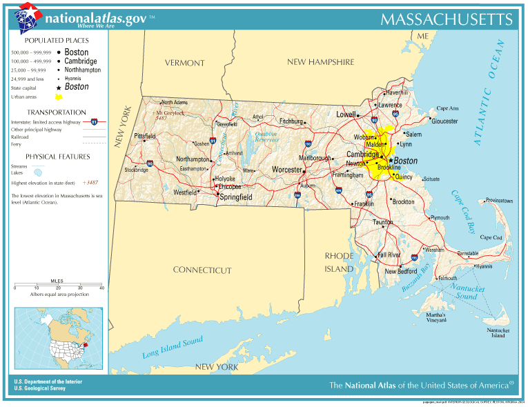
Prominent roads and cities in Massachusetts.
The Massachusetts Bay Colony was named after the indigenous population, the Massachusett, whose name can be segmented as mass-adchu-s-et, where mass- is "large", -adchu- is "hill", -s- is a diminutive suffix meaning "small", and -et is a locative suffix, identifying a place. It has been translated as "near the great hill",[14] "by the blue hills", "at the little big hill", or "at the range of hills", referring to the Blue Hills, or in particular, Great Blue Hill, located on the boundary of Milton and Canton.[15][16] Alternatively, Massachusett has been represented as Moswetuset, from the name of the Moswetuset Hummock (meaning "hill shaped like an arrowhead") in Quincy where Plymouth Colony commander Miles Standish and Squanto, a Native American, met Chief Chickatawbut in 1621.[17][18]
The official name of the state is the "Commonwealth of Massachusetts".[19] Colloquially, it is often referred to simply as "the Commonwealth". While this designation is part of the state's official name, it has no practical implications. Massachusetts has the same position and powers within the United States as other states.[20]
Geography
Massachusetts is the 7th smallest state in the United States. It is located in the New England region of the northeastern United States, and has an area of 10,555 square miles (27,340 km2).[8] Several large bays distinctly shape its coast. Boston is the largest city, at the inmost point of Massachusetts Bay, the mouth of the Charles River, which is the longest river entirely within Massachusetts. Massachusetts extends from the mountains of the Appalachian system in the west to the sandy beaches and rocky shorelines of the Atlantic coast.
The National Park Service administers a number of natural and historical sites in Massachusetts.[21] Along with twelve national historic sites, areas, and corridors, the National Park Service also manages the Cape Cod National Seashore and the Boston Harbor Islands National Recreation Area.[21] In addition, the Massachusetts Department of Conservation and Recreation maintains a number of parks, trails, and beaches throughout Massachusetts.[22][23][24]
Ecology
The primary biome of inland Massachusetts is temperate deciduous forest.[25] Although much of Massachusetts had been cleared for agriculture, leaving only traces of old growth forest in isolated pockets, secondary growth has regenerated in many rural areas as farms have been abandoned.[26] Currently, forests cover around 62% of Massachusetts.[27][28] The areas most affected by human development include the Greater Boston area in the east, the smaller Springfield metropolitan area in the west, and the largely agricultural Pioneer Valley.[29] Animals that have become locally extinct over the past few centuries include gray wolves, elk, wolverines, and mountain lions.[30]
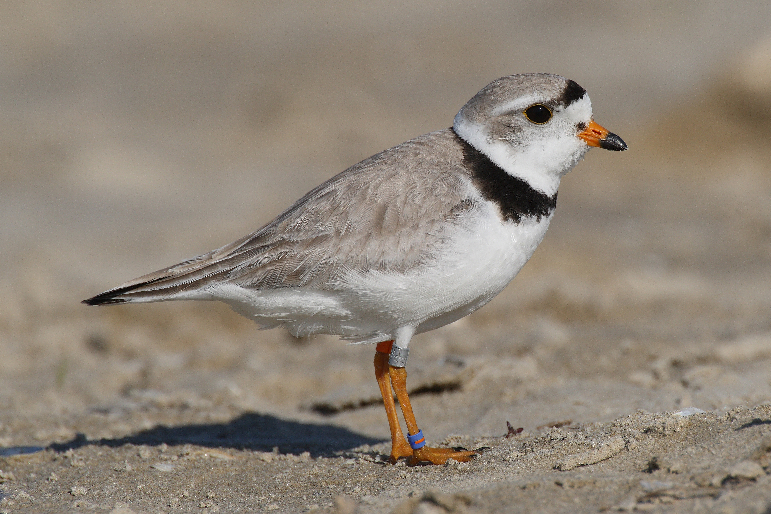

Many coastal areas in Massachusetts provide breeding areas for species such as the Piping Plover.
A number of species are doing well despite (and in some cases because of) the increased urbanization of Massachusetts. Peregrine falcons utilize office towers in larger cities as nesting areas,[31] and the population of coyotes, whose diet may include garbage and roadkill, has been increasing in recent decades.[32] White-tailed deer, raccoons, wild turkeys and eastern gray squirrels are also found throughout Massachusetts.[30][33] In more rural areas in the western part of Massachusetts, larger mammals such as moose and black bears have returned, largely due to reforestation following the regional decline in agriculture.[34][35]
Massachusetts is located along the Atlantic Flyway, a major route for migratory waterfowl along the Atlantic coast.[36] Lakes in central Massachusetts provide habitat for the common loon, especially Quabbin Reservoir,[37] while a significant population of long-tailed ducks winter off Nantucket.[38] Small offshore islands and beaches are home to roseate terns and are important breeding areas for the locally threatened piping plover.[39][40] Protected areas such as the Monomoy National Wildlife Refuge provide critical breeding habitat for shorebirds and a variety of marine wildlife including a large population of gray seals.[41]
Freshwater fish species in Massachusetts include bass, carp, catfish, and trout,[42] while saltwater species such as Atlantic cod, haddock and American lobster populate offshore waters.[43] Other marine species include Harbor seals, the endangered North Atlantic right whales, as well as humpback whales, fin whales, minke whales and Atlantic white-sided dolphins.[30]
History


The Mayflower in Plymouth Harbor by William Halsall (1882) The Pilgrims were a group of Puritans who founded Plymouth in 1620.
Early
Massachusetts was originally inhabited by tribes of the Algonquian language family such as the Wampanoag, Narragansett, Nipmuc, Pocomtuc, Mahican, and Massachusett.[44][45] While cultivation of crops like squash and corn supplemented their diets, these tribes were generally dependent on hunting, gathering and fishing for most of their food supply.[44] Villages consisted of lodges called wigwams as well as long houses,[45] and tribes were led by male or female elders known as sachems.[46]
Colonial period (1620–1780)
In the early 1600s (after contact had been made with Europeans, but before permanent settlements were established), large numbers of the indigenous people in the northeast of what is now the United States were killed by virgin soil epidemics such as smallpox, measles, influenza, and perhaps leptospirosis.[47][48] In 1617–19, smallpox reportedly killed 90% of the Massachusetts Bay Native Americans.[49]
The first English settlers in Massachusetts, the Pilgrims, established their settlement at Plymouth in 1620, and developed friendly relations with the native Wampanoag.[50] This was the second successful permanent English colony in North America, after the Jamestown Colony. The Pilgrims were soon followed by other Puritans, who established the Massachusetts Bay Colony at present-day Boston in 1630.[51]
The Puritans, who believed the Church of England was too hierarchical (among other disagreements), came to Massachusetts for religious freedom,[52] although, unlike the Plymouth colony, the bay colony was founded under a royal charter. Both religious dissent and expansionism resulted in several new colonies being founded shortly after Plymouth and Massachusetts Bay elsewhere in New England. Dissenters such as Anne Hutchinson and Roger Williams were banished due to religious disagreements; (Hutchinson held meetings in her home discussing flaws in the Puritan beliefs, while Williams believed that the Puritan beliefs were wrong, and the Indians must be respected.) In 1636, Williams founded the colony of Rhode Island and Hutchinson joined him there several years later.[53]
In 1691, the colonies of Massachusetts Bay and Plymouth were united (along with present-day Maine, which had previously been divided between Massachusetts and New York) into the Province of Massachusetts Bay.[54] Shortly after the arrival of the new province's first governor, Sir William Phips, the Salem witch trials took place, in which a number of men and women were hanged.[55]
During the Revolution, Salem, Massachusetts became a center for privateering. Although the documentation is incomplete, about 1,700 Letters of Marque, issued on a per-voyage basis, were granted during the American Revolution. Nearly 800 vessels were commissioned as privateers and are credited with capturing or destroying about 600 British ships.[56] During the War of 1812, privateering resumed. The Old China Trade left a significant mark in two historic districts, Chestnut Street District, part of the Samuel McIntire Historic District containing 407 buildings, and the Salem Maritime National Historic Site, consisting of 12 historic structures and about 9 acres (36,000 m2) of land along the waterfront in Salem. Elias Hasket Derby was among the wealthiest and most celebrated of post-Revolutionary merchants in Salem, and owner of the Grand Turk, the first New England vessel to trade directly with China.
The most destructive earthquake yet known in New England occurred in 1755, causing considerable damage across Massachusetts.[57][58]


(1775) "Percy's Rescue at Lexington". , about the Battles of Lexington and Concord.
Massachusetts was a center of the movement for independence from Great Britain; colonists here had long had uneasy relations with the British monarchy, including open rebellion under the Dominion of New England in the 1680s.[54] Protests against British attempts to tax the colonies after the French and Indian War ended in 1763 led to the Boston Massacre in 1770, and the 1773 Boston Tea Party escalated tensions to the breaking point.[59] Anti-Parliamentary activity by men such as Samuel Adams and John Hancock, followed by reprisals by the British government, were a primary reason for the unity of the Thirteen Colonies and the outbreak of the American Revolution.[60]
The Battles of Lexington and Concord initiated the American Revolutionary War and were fought in the Massachusetts towns of Concord and Lexington.[61] Future President George Washington took over what would become the Continental Army after the battle. His first victory was the Siege of Boston in the winter of 1775–76, after which the British were forced to evacuate the city.[62] The event is still celebrated in Suffolk County as Evacuation Day.[63]
Federal period
Bostonian John Adams, known as the "Atlas of Independence", was an important figure in both the struggle for independence as well as the formation of the new United States.[64] Adams was highly involved in the push for separation from Britain and the writing of the Massachusetts Constitution in 1780 (which, in the Elizabeth Freeman and Quock Walker cases, effectively made Massachusetts the first state to have a constitution that declared universal rights and, as interpreted by Supreme Judicial Court Chief Justice William Cushing, abolished slavery).[64][65][lower-alpha 1] Later, Adams was active in early American foreign affairs and succeeded Washington as US President.[64] His son, John Quincy Adams, would go on to become the sixth US President.[64]
After independence and during the formative years of independent American government, Shays' Rebellion was an armed uprising in the western half of the state from 1786 to 1787. The rebels were mostly small farmers angered by crushing war debt and taxes. The rebellion was one of the major factors in the decision to draft a stronger national constitution to replace the Articles of Confederation.[68] On February 6, 1788, Massachusetts became the sixth state to ratify the US Constitution.[69]
19th century
In 1820, Maine separated from Massachusetts, of which it had been first a contiguous and then a non-contiguous part, and entered the Union as the 23rd state as a result of the ratification of the Missouri Compromise.[70]


,_Lowell,_Massachusetts.JPG)
Textile mills such as the Boott Mills in Lowell made Massachusetts a leader in the US industrial revolution.
During the 19th century, Massachusetts became a national leader in the American Industrial Revolution, with factories around Boston producing textiles and shoes, and factories around Springfield producing precision manufacturing tools and paper.[71][72] The economy transformed from one based primarily on agriculture to an industrial one, initially making use of waterpower and later the steam engine to power factories, and canals and later railroads for transporting goods and materials.[73] At first, the new industries drew labor from Yankees on nearby subsistence farms, and later relied upon immigrant labor from Europe and Canada.[74][75]
In the years leading up to the Civil War, Massachusetts was a center of progressivism and abolitionist activity. Horace Mann made the state system of schools the national model.[76] Henry David Thoreau and Ralph Waldo Emerson made major contributions to American thought.[77] Members of the transcendentalist movement, they emphasized the importance of the natural world and emotion to humanity.[77]
Although significant opposition to abolitionism existed early on in Massachusetts, resulting in anti-abolitionist riots between 1835 and 1837,[78] opposition to slavery gradually increased in the next few decades.[79][80] The works of abolitionists contributed to subsequent actions of the state during the Civil War. Massachusetts was the first state to recruit, train, and arm a Black regiment with White officers, the 54th Massachusetts Volunteer Infantry.[81] The Robert Gould Shaw Memorial in Boston Common contains a relief depicting the 54th regiment.[82]
20th century


Part of the "Big Dig" construction project; this portion is over the Charles River.
The industrial economy began a decline in the early 20th century with the exodus of many manufacturing companies. By the 1920s competition from the South and Midwest, followed by the Great Depression, led to the collapse of the three main industries in Massachusetts: textiles, shoemaking, and mechanized transportation.[83] This decline would continue into the later half of the century; between 1950 and 1979, the number of Bay Staters involved in textile manufacturing declined from 264,000 to 63,000.[84] This spurred an exodus of high-paying jobs from Western Massachusetts, which suffered greatly as it de-industrialized during the last 40 years of the 20th century.[85]
In Eastern Massachusetts, following World War II, the economy was transformed from one based on heavy industry into a service and high-tech based economy.[86] Government contracts, private investment, and research facilities led to a new and improved industrial climate, with reduced unemployment and increased per capita income. Suburbanization flourished, and by the 1970s, the Route 128 corridor was dotted with high-technology companies who recruited graduates of the area's many elite institutions of higher education.[87]
The Kennedy family was prominent in Massachusetts politics in the 20th century. Children of businessman and ambassador Joseph P. Kennedy Sr. included John F. Kennedy, who was a senator and US president before his assassination in 1963, Robert F. Kennedy, who was a senator, US attorney general and presidential candidate before his assassination in 1968, Ted Kennedy, a senator from 1962 until his death in 2009,[88] and Eunice Kennedy Shriver, a co-founder of the Special Olympics.[89] The famous Kennedy Compound is located at Hyannisport on Cape Cod.[90]
Recent history
In 1987, the state received federal funding for the Central Artery/Tunnel Project. Commonly known as "the Big Dig", it was at the time the biggest federal highway project ever approved.[91] The project included making the Central Artery a tunnel under downtown Boston, in addition to the re-routing of several other major highways.[92] Often controversial, with numerous claims of graft and mismanagement, and with its initial price tag of $2.5 billion increasing to a final tally of over $15 billion, the Big Dig has nonetheless changed the face of Downtown Boston.[91] It has connected areas that were once divided by elevated highway, (much of the raised old Central Artery was replaced with the Rose Fitzgerald Kennedy Greenway) and improved traffic conditions along a number of routes.[91][92]
On November 6, 2012, a law was passed to eliminate state criminal and civil penalties for the medical use of marijuana. In 2008, marijuana possession was decriminalized for amounts under one ounce.
Demographics

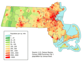
Massachusetts population density map.
| Historical populations | |||
|---|---|---|---|
| Census | Pop. | %± | |
| 1790 | 378,787 | ||
| 1800 | 422,845 | 11.6% | |
| 1810 | 472,040 | 11.6% | |
| 1820 | 523,287 | 10.9% | |
| 1830 | 610,408 | 16.6% | |
| 1840 | 737,699 | 20.9% | |
| 1850 | 994,514 | 34.8% | |
| 1860 | 1,231,066 | 23.8% | |
| 1870 | 1,457,351 | 18.4% | |
| 1880 | 1,783,085 | 22.4% | |
| 1890 | 2,238,947 | 25.6% | |
| 1900 | 2,805,346 | 25.3% | |
| 1910 | 3,366,416 | 20.0% | |
| 1920 | 3,852,356 | 14.4% | |
| 1930 | 4,249,614 | 10.3% | |
| 1940 | 4,316,721 | 1.6% | |
| 1950 | 4,690,514 | 8.7% | |
| 1960 | 5,148,578 | 9.8% | |
| 1970 | 5,689,170 | 10.5% | |
| 1980 | 5,737,037 | 0.8% | |
| 1990 | 6,016,425 | 4.9% | |
| 2000 | 6,349,097 | 5.5% | |
| 2010 | 6,547,629 | 3.1% | |
| Est. 2012 | 6,646,144 | 4.7% | |
| [9][93][94][95] | |||
The United States Census Bureau estimates that the population of Massachusetts was 6,646,144 on July 1, 2012, a 1.5% increase since the 2010 United States Census.[9]
Massachusetts had an estimated 2012 population of 6,646,144.[9] As of 2000, Massachusetts was estimated to be the third most densely populated U.S. state, with 809.8 people per square mile, behind New Jersey and Rhode Island.[8] Massachusetts in 2008 included 919,771 foreign-born residents.
Most Bay Staters live within the Boston Metropolitan Area, also known as Greater Boston, which in its most expansive sense includes New England's two largest cities, Boston and Worcester. The state's only other metropolitan area is the Springfield Metropolitan Area, also known as Greater Springfield. Centered in the Connecticut River Valley, Greater Springfield includes the revitalizing city of Springfield, and an eclectic array of college towns, (e.g. Amherst and Northampton) and rural areas to the north and west. Geographically, the center of population of Massachusetts is located in the town of Natick.[96]
Like the rest of the northeastern United States, the population of Massachusetts has continued to grow in the past few decades, although at a slower pace than states in the South or West.[97] The latest census estimates show that Massachusetts's population grew by 3.9% since 2000, compared with nearly 10% nationwide. In their decisions to leave Massachusetts, most former residents cited high housing costs and a high cost of living.[98] Another factor has been the transformation from a manufacturing economy into one based on high technology, leaving limited employment options for lower-skilled workers, particularly males.[99]
Foreign immigration is more than making up for these losses, causing the state's population to continue to grow as of the 2010 Census (particularly in Massachusetts gateway cities where costs of living are lower).[97][100] 40% of foreign immigrants were from Central or South America, according to a 2005 Census Bureau study. Many residents who have settled in Greater Springfield claim Puerto Rican descent.[97] Many areas of Massachusetts showed relatively stable population trends between 2000 and 2010.[100] Exurban Boston and coastal areas grew the most rapidly, while Berkshire County in far Western Massachusetts and Barnstable County on Cape Cod were the only counties to lose population as of the 2010 Census.[100] Both of these counties feature many "second homes," and constitute major centers of Massachusetts tourism.
In 2005, 79% of the state population spoke English, 7% spoke Spanish, 3.5% spoke Portuguese, and 1% spoke either French or Chinese.[101]
Race and ancestry
According to the 2010 U.S. Census, the population was 6,547,629, of which 3,166,628 (48.4%) were male and 3,381,001 (51.6%) were female. In terms of age, 78.3% were over 18 years old and 13.8% were over 65 years old; the median age is 39.1 years. The median age for males is 37.7 years and 40.3 years for females.
In terms of race and ethnicity, Massachusetts was 84.1% White (76.4% Non-Hispanic Whites), 7.8% Black or African American, 0.5% American Indian and Alaska Native, 5.6% Asian (1.9% Chinese, 1.2% Asian Indian, and 0.7% Vietnamese), <0.1% Native Hawaiian and Other Pacific Islander, 4.7% from Some Other Race, and 2.0% from Two or More Races. Hispanics and Latinos of any race made up 9.9% of the population (4.1% Puerto Rican).[102][103]
The state's most populous ethnic group, non-Hispanic white, has declined from 95.4% in 1970 to 76.4% in 2011.[102][104] As of 2011, non-Hispanic whites were involved in 63.6% of all the births.[105]
As late as 1795, the population of Massachusetts was nearly 95% of English ancestry.[106] During the early and mid 19th century, immigrant groups began arriving to Massachusetts in large numbers; first from Ireland in the 1840s,[107] The Irish and part-Irish are the largest ancestry group in the state at nearly 25% of the total population. Others arrived later from Quebec as well as places in Europe such as Italy and Poland.[108] In the early 20th century, a number of African Americans migrated to Massachusetts, although in somewhat fewer numbers than many other Northern states.[109] Later in the 20th century, immigration from Latin America, Africa, and East Asia increased considerably. Massachusetts has the third largest population of Haitians in the United States.[110]
Massachusetts also has a relatively large population of Portuguese descent. Many of the earliest Portuguese-speaking immigrants came from the Azores in the 19th century to work in the whaling industry in cities like New Bedford.[111][112] Later, further waves of Portuguese arrived, this time often finding work in the textile mills.[112] Lowell is home to the second largest Cambodian (Khmer) community in the nation.[113] The Wampanoag tribe maintains reservations at Aquinnah on Martha's Vineyard, at Grafton, and at Mashpee on Cape Cod,[114][115] while the Nipmuck maintain two state-recognized reservations in the central part of the state. While Massachusetts had avoided many of the more violent forms of racial strife seen elsewhere in the US, examples such as the successful electoral showings of the nativist (mainly anti-Catholic) Know Nothings in the 1850s,[116] the controversial Sacco and Vanzetti executions in the 1920s,[117] and Boston's opposition to desegregation busing in the 1970s[118] show that the ethnic history of Massachusetts was not completely harmonious.
Religion
Massachusetts was founded and settled by the Puritans in 1628. The descendants of the Puritans belong to many different churches; in the direct line of inheritance are the Congregational/United Church of Christ, and congregations of Unitarian Universalist Association. Most people in Massachusetts were Christians. The headquarters of the Unitarian Universalist Association is located on Beacon Hill in Boston.[119]
Today, Protestants make up less than 1/4 of the state's population. Roman Catholics now predominate because of massive immigration from primarily Ireland, followed by Italy, Portugal, Quebec, and Latin America. A large Jewish population came to the Boston and Springfield areas 1880–1920. Mary Baker Eddy made the Boston Mother Church of Christian Science the world headquarters. Buddhists, Pagans, Hindus, Seventh-day Adventists, Muslims, and Mormons also can be found. Kripalu Center in Stockbridge, the Shaolin Meditation Temple in Springfield, and the Insight Meditation Center in Barre are examples of non-western religious centers in Massachusetts. According to the Association of Religion Data Archives the largest single denominations are the Roman Catholic Church with 3,092,296; the United Church of Christ with 121,826; and the Episcopal Church with 98,963 adherents. Jewish congregations had about 275,000 members.[120]
The religious affiliations of the people of Massachusetts, according to a 2001 survey, are shown below:[121]


Built in 1681, the Old Ship Church in Hingham is the oldest church in America in continuous ecclesiastical use.[122]
- Christian – 69%
- Catholic – 44%
- Protestant denominations – 25%
- Non-specific Protestant – 4%
- Baptist – 4%
- Congregational/United Church of Christ – 3%
- Episcopal – 3%
- Other denominations (2% or less each) – 11%
- Jewish – 2%
- Muslim – 1%
- Other – 7%
- No Religion – 16%
- Refused to answer – 7%
Economy
The United States Bureau of Economic Analysis estimates that the Massachusetts gross state product in 2008 was US$365 billion.[123] The per capita personal income in 2008 was $50,735, making it the third highest state in the nation.[124] 13 Fortune 500 companies are located in Massachusetts, the largest of which are the Liberty Mutual Insurance Group of Boston and MassMutual Financial Services of Springfield.[125] CNBC's list of "Top States for Business for 2010" has recognized Massachusetts as the fifth best state in the nation.[126]

Stephen Phillips House by Salem, Massachusetts in Samuel McIntire an American architect and craftsman, Chestnut Street District, a legacy to one of the earliest architects in the United States, Samuel McIntyre is a primary example of Federal style architecture - Chestnut Street District.
Sectors vital to the Massachusetts economy include higher education, biotechnology, finance, health care, and tourism. Route 128 was a major center for the development of minicomputers and electronics.[87] High technology remains an important sector, though few of the largest technology companies are based there. In recent years tourism has played an ever-important role in the state's economy, with Boston and Cape Cod being the leading destinations. Other popular tourist destinations include Salem, Plymouth and the Berkshires. As of June 2012, the state's unemployment rate was 6.0%,[127] well below the national level of 8.2%.

Cape Cod Bay, a leading tourist destination in Massachusetts. Tourism is of growing importance to the state's economy.
As of 2005, there were 7,700 farms in Massachusetts encompassing a total of 520,000 acres (2,100 km2), averaging 68 acres (0.275 km2) apiece.[128] Almost 2,300 of the state's 6,100 farms grossed under $2,500 in 2007.[128] Particular agricultural products of note include tobacco, livestock, and fruits, tree nuts, and berries, for which the state is nationally ranked 11th, 17th, and 16th, respectively.[128] Massachusetts is the second largest cranberry producing state in the union (after Wisconsin).[129]
Taxation
The overall state and local tax burden in Massachusetts ranks 11th highest in the United States.[130] Massachusetts has a flat-rate personal income tax of 5.25%,[131] after a 2002 voter referendum to eventually lower the rate to 5.0%.[132] There is an exemption for income below a threshold that varies from year to year. The corporate income tax rate is 8.8%,[130] and the short-term capital gains tax rate is 12%.[133]
The state imposes a 6.25% sales tax[130] on retail sales of tangible personal property—except for groceries, clothing (up to $175.00), and periodicals.[134] The sales tax is charged on clothing that costs more than $175.00, for the amount exceeding $175.00.[134] All real and tangible personal property located within the Commonwealth of Massachusetts is taxable unless specifically exempted by statute. Property taxes in the state were the eighth highest in the nation.[130] There is no inheritance tax and limited Massachusetts estate tax related to federal estate tax collection.[133]
Energy
The state's electricity generation market was made competitive in 1998, enabling retail customers to change suppliers without changing utility companies.[135] Though most residential customers remain with incumbent generators, most of the 4.3 billion kilowatt-hours consumed in the state in July 2011 were generated competitively.[136] In 2011, Massachusetts was ranked as the most energy efficient state in America.[137]
Transportation

The Massachusetts Bay Transportation Authority, serving Greater Boston.
Massachusetts has 10 regional metropolitan planning organizations and three non-metropolitan planning organizations covering the remainder of the state; statewide planning is handled by the Massachusetts Department of Transportation.
Rail service
Amtrak operates inter-city rail, including the high-speed Acela service to cities such as Providence, New Haven, New York City, and Washington, DC.[138]
Regional services
The Massachusetts Bay Transportation Authority (MBTA) operates public transportation in the form of subway,[139] bus[140] and ferry[141] systems in the Metro Boston area. It also operates longer distance commuter rail services throughout the larger Greater Boston area, including service to Worcester and Providence, Rhode Island.[142]
Fifteen other regional transit authorities provide public transportation in the form of bus services in their local communities.[143] Two heritage railways are in operation: the Cape Cod Central Railroad and the Berkshire Scenic Railway.[144][145]
As of 2006, a number of freight railroads were operating in Massachusetts, with CSX being the largest carrier. Massachusetts has a total of 1,079 miles (1,736 km) of freight trackage in operation.[146] The Woods Hole, Martha's Vineyard and Nantucket Steamship Authority regulates freight and passenger ferry service to the islands and operates some of those lines.[147]
Air service

Worcester, second largest city in the state, with Worcester Regional Airport tower in the background
The major airport in the state is Logan International Airport. The airport served over 28 million passengers in 2007 and is used by around 50 airlines.[148] Logan International Airport has service to numerous cities throughout the United States, as well as international service to Canada, Mexico, the Caribbean, Europe and Asia. Logan, Hanscom Field in Bedford, and Worcester Regional Airport are operated by Massport, an independent state transportation agency.[148] Massachusetts has approximately 42 public-use airfields, and over 200 private landing spots.[149] Some airports receive funding from the Aeronautics Division of the Massachusetts Department of Transportation and the Federal Aviation Administration; FAA is also the primary regulator.
Road
There are a total of 31,300 miles (50,400 km) of interstates and highways in Massachusetts.[150] Interstate 90, also known as the Massachusetts Turnpike, is the longest interstate in Massachusetts. The route runs 136 mi (219 km) generally west to east from the New York state line near the town of West Stockbridge and passes just north of Springfield, just south of Worcester and through Framingham before terminating near Logan International Airport in Boston. Other major interstates include Interstate 91, which runs generally north and south along the Connecticut River, Interstate 93, which runs north and south through central Boston, then passes Methuen and Lawrence before entering New Hampshire. Interstate 95, which follows most of the US Atlantic coastline, connects Providence, Rhode Island with Greater Boston, forming a loop around the more urbanized areas (for some distance cosigned with Route 128) before continuing north along the coast.
Interstate 495 forms a wide loop around the outer edge of Greater Boston. Other major interstates in Massachusetts include I-291, I-391, I-84, I-195, I-395, I-290, and I-190. Major non-interstate highways in Massachusetts include U.S. Routes 1, 3, 6, and 20, and state routes 2, 3, 24 and 128. A great majority of interstates in Massachusetts were constructed during the mid 20th century, and at times were controversial, particularly the routing of I-95 through central Boston. Opposition to continued construction grew, and in 1970 Governor Francis W. Sargent issued a general prohibition on most further freeway construction within the I-95/Route 128 loop in the Boston area.[151] A massive undertaking to depress I-93 in downtown Boston, called the Big Dig, has brought the city's highway system under public scrutiny over the last decade.[91]
Government and politics
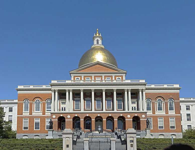

Massachusetts State House facing Boston Common.
The government of Massachusetts is divided into three branches: executive, legislative, and judicial. Massachusetts has a long political history; earlier political structures included the Mayflower Compact of 1620, the separate Massachusetts Bay and Plymouth colonies, and the combined colonial Province of Massachusetts. The Massachusetts Constitution was ratified in 1780 while the Revolutionary War was in progress, four years after the Articles of Confederation was drafted, and eight years before the present United States Constitution was ratified on June 21, 1788. Drafted by John Adams, Massachusetts's constitution is one of the oldest functioning written constitutions in continuous effect in the world.[152]
In recent decades, Massachusetts politics have been generally dominated by the Democratic Party, and the state has a reputation for being one of the most liberal in the country. In 1974, Elaine Noble became the first openly lesbian or gay candidate elected to a state legislature in US history.[153] The state housed the first openly gay member of the United States House of Representatives, Gerry Studds.
Government
The Government of Massachusetts is divided into three branches: Executive, Legislative, and Judicial. The governor of Massachusetts heads the executive branch; duties of the governor include signing or vetoing legislation, filling judicial and agency appointments, granting pardons, preparing an annual budget, and commanding the Massachusetts National Guard.[154] Massachusetts governors, unlike those of most other states, are addressed as His/Her Excellency.[154] The current governor is Deval Patrick, a Democrat from Milton. The executive branch also includes the Executive Council, which is made up of eight elected councilors and the Lieutenant Governor.[154]
Abilities of the Council include confirming gubanatorial appointments and certifying elections.[154] The Massachusetts House of Representatives and Massachusetts Senate comprise the legislature of Massachusetts, known as the Massachusetts General Court.[154] The House consists of 160 members while the Senate has 40 members.[154] Leaders of the House and Senate are chosen by the members of those bodies; the leader of the House is known as the Speaker while the leader of the Senate is known as the President.[154] Each branch consists of several committees.[154] Members of both bodies are elected to two-year terms.
The Judicial branch is headed by the Supreme Judicial Court, which serves over a number of lower courts.[154] The Supreme Judicial Court is made up of a chief justice and six associate justices.[154] Judicial appointments are made by the governor and confirmed by the executive council.[154]
The Congressional delegation from Massachusetts is entirely Democratic.[155][156] Currently, the US senators are Democrats Mo Cowan and Elizabeth Warren. The nine members of the state's delegation to the US House of Representatives (all Democrats) are Richard Neal, Jim McGovern, Niki Tsongas, Joseph Kennedy III, Ed Markey, John F. Tierney, Mike Capuano, Stephen Lynch, and Bill Keating.[156]
Federal court cases are heard in the United States District Court for the District of Massachusetts, and appeals are heard by the United States Court of Appeals for the First Circuit.[157] In US presidential elections, Massachusetts is allotted 11 votes in the electoral college, out of a total of 538.[158] Like most states, Massachusetts's electoral votes are granted in a winner-take-all system.[159]
Politics
| Year | Republican | Democratic |
|---|---|---|
| 2012 | 38% 1,178,510 | 61% 1,906,319 |
| 2008 | 36% 1,108,854 | 62% 1,904,098 |
| 2004 | 37% 1,070,109 | 62% 1,803,801 |
| 2000 | 33% 878,502 | 60% 1,616,487 |
| 1996 | 28% 718,107 | 62% 1,571,763 |
| 1992 | 29% 805,049 | 48% 1,318,662 |
| 1988 | 46% 1,194,635 | 53% 1,401,416 |
Throughout the mid 20th century, Massachusetts has gradually shifted from a Republican-leaning state to one largely dominated by Democrats; the 1952 victory of John F. Kennedy over incumbent Senator Henry Cabot Lodge, Jr. is seen as a watershed moment in this transformation. His younger brother Edward M. Kennedy held that seat until his death from a brain tumor in 2009.[160] Massachusetts has since gained a reputation as being a politically liberal state and is often used as an archetype of modern liberalism, hence the usage of the phrase "Massachusetts liberal".[161]
Massachusetts routinely votes for the Democratic Party, with the core concentrations in the Boston metro area, the Cape and Islands, and Western Massachusetts. Pockets of Republican strength are in the central areas along the I-495 crescent, and communities on the south and north shores,[162] but the state as a whole has not given its Electoral College votes to a Republican in a presidential election since Ronald Reagan carried it in 1984. Additionally, Massachusetts provided Reagan with his smallest margins of victory in both the 1980 and 1984 elections. In recent elections, even Scott Brown's 2010 win, Western MA is more reliably blue (by city/town) than Eastern MA.
As of the 2006 election, the Republican party holds less than 13% of the seats in both legislative houses of the General Court: in the House, the balance is 141 Democratic to 19 Republican, and in the Senate, 35–5.[163]
Although Republicans held the governor's office continuously from 1991 to 2007, they have been among the more moderate Republican leaders in the nation.[164][165] In the 2004 election, Massachusetts gave native son John Kerry 61.9% of the vote, his best showing in any state.[166] In 2008, President Barack Obama carried the state with 61.8% of the vote.[167] In a recent statewide election, a special election in 2010 for the U.S. Senate, saw Republican Scott Brown defeat Democrat Martha Coakley in an upset, by a 52% to 47% margin.[168]
A number of contemporary national political issues have been influenced by events in Massachusetts, such as the 2003 state Supreme Court decision allowing same-sex marriage[169] and a 2006 bill which mandated health insurance for all Bay Staters.[170] In 2008, Massachusetts voters passed an initiative decriminalizing possession of small amounts of marijuana.[171] Marijuana was legalized for medical use on November 6, 2012.
Cities, towns, and counties

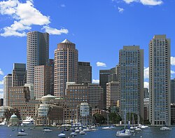
Boston, the capital and largest city of Massachusetts.
There are 50 cities and 301 towns in Massachusetts, grouped into 14 counties.[172] The fourteen counties, moving roughly from west to east, are Berkshire, Franklin, Hampshire, Hampden, Worcester, Middlesex, Essex, Suffolk, Norfolk, Bristol, Plymouth, Barnstable, Dukes, and Nantucket. Eleven communities which call themselves "towns" are, by law, cities since they have traded the town meeting form of government for a mayor-council or manager-council form.[173]
Boston is the state capital and largest city in Massachusetts. The population of the city proper is 609,023,[174] and Greater Boston, with a population of 4,522,858, is the 10th largest metropolitan area in the nation.[175] Other cities with a population over 100,000 include Worcester, Springfield, Lowell, and Cambridge.[176] Plymouth is the largest municipality in the state by land area.[172]
Massachusetts, along with the five other New England states, features the local governmental structure known as the New England town.[177] In this structure, incorporated towns—as opposed to townships or counties—hold many of the responsibilities and powers of local government.[177] Some of the county governments were abolished by Massachusetts in 1997, and elect only a sheriff and registrar of deed who are part of the state government.[178] Others have been reorganized, and a few still retain county councils.[178]
Education
Massachusetts was the first state to require municipalities to appoint a teacher or establish a grammar school with the passage of the Massachusetts Education Law of 1647,[179] and 19th century reforms pushed by Horace Mann, founder of Westfield State University, laid much of the groundwork for contemporary universal public education.[180][181] Massachusetts is home to the country's oldest public elementary school (The Mather School, founded in 1639), oldest high school (Boston Latin School, founded in 1635),[182] oldest boarding school (The Governor's Academy, founded in 1763), oldest college (Harvard University, founded in 1636)[183] and oldest women's college (Mount Holyoke College, founded in 1837).[184]
In 1852, Massachusetts became the first state to pass compulsory school attendance laws.[185] The per-student public expenditure for elementary and secondary schools (kindergarten through grade 12) was fifth in the nation in 2004, at $11,681.[186] In 2007, Massachusetts scored highest of all the states in math on the National Assessments of Educational Progress.[187]
Massachusetts is home to 121 institutions of higher education.[188] Harvard University and the Massachusetts Institute of Technology, both located in Cambridge, consistently rank among the world's best universities.[189][190][191] In addition to Harvard and MIT, several other Massachusetts universities consistently rank in the top 40 at the national level in the widely cited rankings of U.S. News and World Report: Tufts University (#29 for 2012), Boston College (#31), and Brandeis University (also #31).
Among liberal arts colleges, three of the top handful in the nation are within the state of Massachusetts: Williams College (#1 in the liberal arts ranking of USNWR), Amherst College (#2), and Wellesley College (#6). Others regularly placing in the top 40 are Smith College (#19), College of the Holy Cross (#29), and Mount Holyoke College (also #29). According to this "granddaddy of the college rankings", roughly five (12.5%) of the top 40 research universities and six (15%) of the top 40 liberal arts colleges reside in this state that contains only 2% of the U.S. population.
The public University of Massachusetts (nicknamed UMass) features five campuses in the state, with its flagship campus in Amherst that enrolls over 25,000 students.[192][193]
Arts and culture
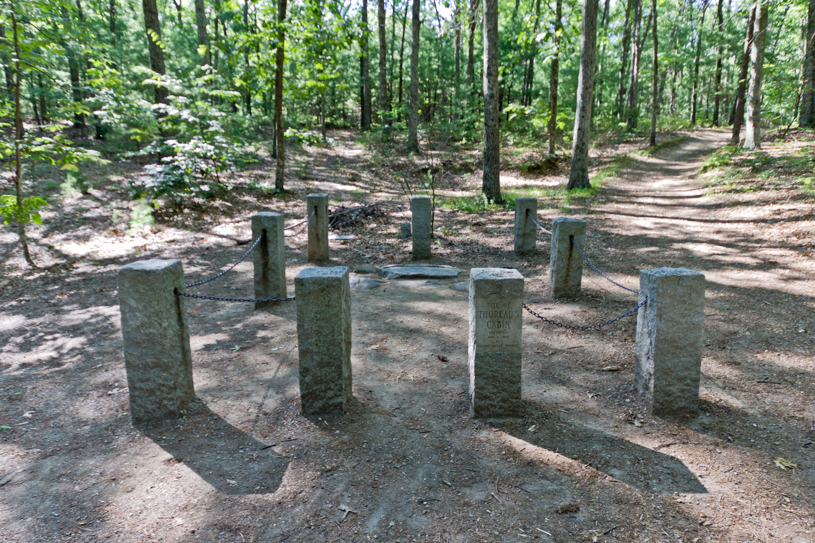

The site of Henry David Thoreau's cabin at Walden Pond near Concord.
Massachusetts has contributed much to American arts and culture. Drawing from its Native American and Yankee roots, along with later immigrant groups, Massachusetts has produced a number of writers, artists, and musicians. A number of major museums and important historical sites are also located there, and events and festivals throughout the year celebrate the state's history and heritage.
Massachusetts was an early center of the Transcendentalist movement, which emphasized intuition, emotion, human individuality and a deeper connection with nature.[77] Ralph Waldo Emerson, who was from Boston but spent much of his later life in Concord, largely created the philosophy with his 1836 work Nature, and continued to be a key figure in the movement for the remainder of his life. Emerson's friend, Henry David Thoreau, who was also involved in Transcendentalism, recorded his year spent alone in a small cabin at nearby Walden Pond in the 1854 work Walden; or, Life in the Woods.[194]
Other famous authors and poets born or strongly associated with Massachusetts include Nathaniel Hawthorne, John Updike, Emily Dickinson, Henry Wadsworth Longfellow, E.E. Cummings, Sylvia Plath, and Theodor Seuss Geisel, better known as "Dr. Seuss".[195][196][197] Famous painters from Massachusetts include Winslow Homer and Norman Rockwell;[197] many of the latter's works are on display at the Norman Rockwell Museum in Stockbridge.[198]
An outdoor dance performance at Jacob's Pillow in Becket.
Massachusetts is also an important center for the performing arts. Both the Boston Symphony Orchestra and Boston Pops Orchestra are based in Massachusetts.[199] Other orchestras in Massachusetts include the Cape Cod Symphony Orchestra in Barnstable and the Springfield Symphony Orchestra.[200][201] Tanglewood, in western Massachusetts, is a music venue that is home to both the Tanglewood Music Festival and Tanglewood Jazz Festival, as well as the summer host for the Boston Symphony Orchestra.[202][203] Jacob's Pillow in the Berkshires hosts a number of traditional and contemporary musical and dance events.[204]
Other performing arts and theater organizations in Massachusetts include the Boston Ballet,[205] the Boston Lyric Opera,[199] and the Lenox-based Shakespeare & Company.[206] In addition to classical and folk music, Massachusetts has produced musicians and bands spanning a number of contemporary genres, such as the classic rock band Aerosmith, the New Wave band The Cars, and the alternative rock band Pixies.[207] Film events in the state include the Boston Film Festival, the Boston International Film Festival, and a number of smaller film festivals in various cities throughout Massachusetts.[208]


USS Constitution fires a salute during its annual Fourth of July turnaround cruise.
Massachusetts is home to a large number of museums and historical sites. The Boston Museum of Fine Arts, the Institute of Contemporary Art and the DeCordova contemporary art and sculpture museum in Lincoln are all located within Massachusetts,[209][210] and the Maria Mitchell Association in Nantucket includes several observatories, museums, and an aquarium.[211] Historically themed museums and sites such as the Springfield Armory National Historic Site in Springfield,[21] Boston's Freedom Trail and nearby Minute Man National Historical Park, both of which preserve a number of sites important during the American Revolution,[21][212] the Lowell National Historical Park, which focuses on some of the earliest mills and canals of the industrial revolution in the US,[21] the Black Heritage Trail in Boston, which includes important African-American and abolitionist sites in Boston,[213] and the New Bedford Whaling National Historical Park[21] all showcase various periods of Massachusetts's history.
Plimoth Plantation and Old Sturbridge Village are two open-air or "living" museums in Massachusetts, recreating life as it was in the 17th and early 19th centuries, respectively.[214][215] Boston's annual St. Patrick's Day parade and "Harborfest", a week-long Fourth of July celebration featuring a fireworks display and concert by the Boston Pops as well as a turnaround cruise in Boston Harbor by the USS Constitution,[216] are popular events. The New England Summer Nationals, an auto show in Worcester, draws tens of thousands of attendees every year.[217]
Media
There are two major television media markets located in Massachusetts. The Boston/Manchester market is the fifth largest in the United States.[218] All major networks are represented. The other market surrounds the Springfield area. WGBH-TV in Boston is a major public television station and produces national programs such as Nova, Frontline, and American Experience.[219][220]
The Boston Globe, Boston Herald, Springfield Republican and the Worcester Telegram & Gazette are Massachusetts's largest daily newspapers.[221] In addition, there are many community dailies and weeklies. There are a number of major AM and FM stations which serve Massachusetts,[222] along with many more regional and community-based stations. Some colleges and universities also operate campus television and radio stations, and print their own newspapers.[223][224][225][226][227]
Health
Massachusetts generally ranks highly among states in most health and disease prevention categories. In 2009, the United Health Foundation ranked the state as third healthiest overall.[228] However, the study also pointed to several areas in which Massachusetts ranked below average, such as the state's rate of binge drinking, which was the 11th highest in the country.[228] Massachusetts has the most doctors per 100,000 residents,[229] the second lowest infant mortality rate,[230] and the lowest percentage of uninsured residents (for both children as well as the total population).[231] According to Businessweek, commonwealth residents have an average life expectancy of 78.4 years, the fifth longest in the country.[232] 37.2% of the population is overweight and 21.7% is obese,[233] and Massachusetts ranks sixth highest in the percentage of residents who are considered neither obese nor overweight (41.1%).[233]
The nation's first Marine Hospital was erected by federal order in Boston in 1799.[234][235] The Massachusetts Board of Registration in Medicine lists a total of 132 hospitals in the state.[236] According to rankings by US News & World Report, Massachusetts General Hospital in Boston is the third best overall hospital in the nation;[237] the hospital also ranked first in psychiatry.[238] Massachusetts General was founded in 1811 and serves as the largest teaching hospital for nearby Harvard University.[239]
Other teaching and medical institutions affiliated with Harvard include Brigham and Women's Hospital, Beth Israel Deaconess Medical Center and Dana-Farber Cancer Institute, among others.[240] Boston is also the location of New England Baptist Hospital, Tufts Medical Center and Boston Medical Center, the latter of which is the primary teaching hospital for Boston University.[241] The University of Massachusetts Medical School is located in Worcester.[242] The Massachusetts College of Pharmacy and Health Sciences has campuses in both Boston and Worcester.[243]
Sports and recreation
Organized sports

TD Garden in Boston is home to the Boston Celtics of the NBA and the Boston Bruins of the NHL.
The Olympic sports of basketball and volleyball were invented in Western Massachusetts (in Springfield at Springfield College and Holyoke, respectively). The Basketball Hall of Fame, a shrine to the sport's history, is a major tourist destination in the City of Springfield. The Volleyball Hall of Fame is located in Holyoke.[244]
Massachusetts has a long history with amateur athletics and professional teams. Most of the major professional teams have won multiple championships in their respective leagues. Massachusetts teams have won six Stanley Cups (Boston Bruins),[245] seventeen NBA Championships (Boston Celtics),[246] three Super Bowls (New England Patriots),[247] and eight World Series (seven for the Boston Red Sox, one for the Boston Braves).[248] The American Hockey League, (AHL,) the NHL's development league, is headquartered in Springfield. Other professional sports teams in Massachusetts include the Springfield Falcons AHL team, the Worcester Sharks AHL team, and the Springfield Armor NBA Development League team.
Massachusetts is also the home of the Cape Cod Baseball League, rowing events such as the Eastern Sprints on Lake Quinsigamond in Worcester and the Head of the Charles Regatta,[249][250] and the Boston Marathon.[251] A number of major golf events have taken place in Massachusetts, including nine U.S. Opens and two Ryder Cups, among others.[252][253][254] The New England Revolution is the Major League Soccer team in Massachusetts,[255] and the Boston Cannons are the Major League Lacrosse team.[256] The Boston Breakers are the Women's Professional Soccer in Massachusetts.
A gymnastics center called Brestyan's American Gymnastics has also become well known in the competitive gymnastics world in the last decade for producing several internationally successful gymnasts like Olympic silver medalist and vault world champion Alicia Sacramone, 2011 world champion and two time Olympic Gold medalist Aly Raisman, and Canadian national team member Talia Chiarelli.
Several universities in Massachusetts are notable for their college athletics. Boston College fields teams in the nationally televised Atlantic Coast Conference, while Harvard University competes in the famed Ivy League. Boston University, Northeastern University, College of the Holy Cross, and UMass also participate in Division I athletics.[257][258] Many other Massachusetts colleges compete in lower divisions such as Division III, where MIT, Amherst College, Williams College, and others field teams.
Outdoor recreation
Long-distance hiking trails in Massachusetts include the Appalachian Trail, the New England National Scenic Trail, the Metacomet-Monadnock Trail, the Midstate Trail, and the Bay Circuit Trail.[259][260] Other outdoor recreational activities in Massachusetts include sailing and yachting, freshwater and deep-sea fishing,[261] whale watching,[262] downhill and cross-country skiing,[263] and hunting.
See also
- Massachusetts [colonists]
- Outline of Massachusetts
- Index of Massachusetts-related articles
- Culture of Colonial Massachusetts
- First Families of Massachusetts
- Boston Brahmin
References
Notes
- ^ "50 States". Retrieved on November 3, 2012. .
- ^ "Encyclopædia Britannica". .
- ^ "A Colorful Battle Is Lodge vs. Curley". The Milwaukee Journal. Oct 18, 1936. http://news.google.com/newspapers?nid=1499&dat=19361018&id=A65QAAAAIBAJ&sjid=ASIEAAAAIBAJ&pg=7015,741245. Retrieved November 3, 2012. "One of the Codfish State...".
- ^ "Massachusetts General Laws, Chapter 2, Section 35: Designation of citizens of commonwealth". The Commonwealth of Massachusetts. http://www.mass.gov/legis/laws/mgl/2-35.htm. Retrieved February 29, 2008.
- ^ (1877) "Collections". .
- ^ Jones, Thomas (1879). DeLancey, Edward Floyd. ed. History of New York During the Revolutionary War. New York: New York Historical Society. p. 465. http://books.google.com/books?id=pbuXATAHXMEC.
- ^ wiktionary:Massachusettsian.
- ^ a b c "Population, Housing Units, Area, and Density (geographically ranked by total population): 2000". United States Census Bureau. http://factfinder.census.gov/servlet/GCTTable?_bm=n&_lang=en&mt_name=DEC_2000_SF1_U_GCTPH1R_US9S&format=US-9S&_box_head_nbr=GCT-PH1-R&ds_name=DEC_2000_SF1_U&geo_id=01000US. Retrieved May 30, 2010.
- ^ a b c d "Annual Estimates of the Population for the United States, Regions, States, and Puerto Rico: April 1, 2010 to July 1, 2012" (CSV). 2012 Population Estimates. United States Census Bureau, Population Division. December 2012. http://www.census.gov/popest/data/state/totals/2012/tables/NST-EST2012-01.csv. Retrieved December 22, 2012.
- ^ "Greylock RM 1 Reset". NGS data sheet. U.S. National Geodetic Survey. http://www.ngs.noaa.gov/cgi-bin/ds_mark.prl?PidBox=MZ1957.
- ^ a b "Elevations and Distances in the United States". United States Geological Survey. 2001. http://egsc.usgs.gov/isb/pubs/booklets/elvadist/elvadist.html. Retrieved October 21, 2011.
- ^ Elevation adjusted to North American Vertical Datum of 1988.
- ^ Levenson, Michael (August 9, 2006). "Can you guess the state sport of Massachusetts?". Boston Globe. http://www.boston.com/news/local/articles/2006/08/09/can_you_guess_the_state_sport_of_massachusetts/. Retrieved February 14, 2012.
- ^ Tooker, William Wallace (1904). "Algonquian Names of some Mountains and Hills". http://books.google.com/books?id=U5cqAAAAYAAJ&pg=PA175.
- ^ Salwen, Bert, 1978. Indians of Southern New England and Long Island: Early Period. In "Northeast", ed. Bruce G. Trigger. Vol. 15 of "Handbook of North American Indians", ed. William C. Sturtevant, pp. 160–76. Washington DC: Smithsonian Institution. Quoted in: Campbell, Lyle. 1997. American Indian Languages: The Historical Linguistics of Native America. Oxford: Oxford University Press, p. 401
- ^ Bright, William (2004). Native American Place Names of the United States. Norman: University of Oklahoma Press, p. 270
- ^ "East Squantum Street (Moswetuset Hummock)". Quincy, Mass. Historical and Architectural Survey. Thomas Crane Public Library. 1986. http://thomascranelibrary.org/htm/436.htm. Retrieved June 24, 2009.
- ^ Neal, Daniel (1747). "XIV: The Present State of New England". The history of New-England. 2 (2 ed.). London: A. Ward. p. 216. OCLC 8616817. http://books.google.com/?id=u3opAAAAYAAJ&pg=PA216. Retrieved June 24, 2009.
- ^ "Part One: Concise Facts – Name". Secretary of the Commonwealth of Massachusetts. http://www.sec.state.ma.us/cis/cismaf/mf1a.htm. Retrieved May 22, 2010.
- ^ "Kentucky as a Commonwealth". Kentucky Department for Libraries and Archives. http://www.kdla.ky.gov/resources/KYCommonwealth.htm. Retrieved May 22, 2010.
- ^ a b c d e f "Massachusetts". National Park Service. http://www.nps.gov/state/MA/. Retrieved May 26, 2010.
- ^ "Massachusetts State Parks". Massachusetts Department of Conservation and Recreation. http://www.mass.gov/dcr/listing.htm. Retrieved May 26, 2010.
- ^ "Trail Maps". Massachusetts Department of Conservation and Recreation. http://www.mass.gov/dcr/parks/trails.htm. Retrieved May 26, 2010.
- ^ "Getting Wet!". Massachusetts Department of Conservation and Recreation. http://www.mass.gov/dcr/recreate/swimming.htm. Retrieved May 26, 2010.
- ^ "A Short Introduction to Terrestrial Biomes". Nearctica. http://www.nearctica.com/ecology/habitats/biointro.htm. Retrieved October 17, 2009.
- ^ Stocker, Carol (November 17, 2005). "Old growth, grand specimens drive big-tree hunters". The Boston Globe. http://www.boston.com/yourlife/home/articles/2005/11/17/old_growth_grand_specimens_drive_big_tree_hunters/. Retrieved October 17, 2009.
- ^ "Current Research — Working Landscapes". The Center for Rural Massachusetts — The University of Massachusetts Amherst. http://www.umass.edu/ruralmass/currentresearch.html. Retrieved March 19, 2009.
- ^ "Massachusetts Forests". MassWoods Forest Conservation Program — The University of Massachusetts Amherst. http://www.masswoods.net/index.php/forests. Retrieved March 19, 2009.
- ^ "Northeastern Coastal Zone — Ecoregion Description". United States Geological Survey. http://landcovertrends.usgs.gov/east/eco59Report.html. Retrieved October 17, 2009.
- ^ a b c "State Mammal List". Massachusetts Division of Fisheries & Wildlife. http://www.mass.gov/dfwele/dfw/wildlife/facts/mammals/mammal_list.htm. Retrieved October 17, 2009.
- ^ "Peregrine Falcon" (PDF). Massachusetts Division of Fisheries & Wildlife. http://www.mass.gov/dfwele/dfw/nhesp/species_info/nhfacts/falco_peregrinus.pdf. Retrieved May 26, 2010.
- ^ "Eastern Coyote in Massachusetts". Massachusetts Division of Fisheries & Wildlife. http://www.mass.gov/dfwele/dfw/wildlife/living/living_with_coyotes.htm. Retrieved May 26, 2010.
- ^ "Wild Turkey in Massachusetts" (PDF). Massachusetts Division of Fisheries & Wildlife. http://www.mass.gov/dfwele/dfw/wildlife/living/pdf/living%20_with_turkeys.pdf. Retrieved May 26, 2010.
- ^ "Moose in Massachusetts". Massachusetts Division of Fisheries & Wildlife. http://www.mass.gov/dfwele/dfw/wildlife/living/living_with_moose.htm. Retrieved May 26, 2010.
- ^ "Black Bears in Massachusetts". Massachusetts Division of Fisheries & Wildlife. http://www.mass.gov/dfwele/dfw/wildlife/living/living_with_bears.htm. Retrieved May 26, 2010.
- ^ "Atlantic Flyway". University of Nebraska. http://www.unl.edu/nac/atlas/Map_Html/Biodiversity/National/Atlantic_flyway/Atlantic_Flyway.htm. Retrieved May 22, 2010.
- ^ "Common Loon" (PDF). Massachusetts Division of Fisheries & Wildlife. http://www.mass.gov/dfwele/dfw/nhesp/species_info/nhfacts/gavia_immer.pdf. Retrieved May 28, 2010.
- ^ "Telemetry Research:Long-Tailed Ducks". Mass Audubon. http://www.massaudubon.org/Conservation_Science/Tracking/LTDUresearch.php. Retrieved May 28, 2010.
- ^ "Roseate Tern". Massachusetts Division of Fisheries & Wildlife. http://www.mass.gov/dfwele/dfw/nhesp/species_info/nhfacts/roseate_tern.pdf. Retrieved May 28, 2010.
- ^ "Coastal Waterbird Program". Mass Audubon. http://www.massaudubon.org/cwp/. Retrieved May 28, 2010.
- ^ "Monomoy National Wildlife Refuge – Wildlife and Habitat". United States Fish and Wildlife Service. http://www.fws.gov/northeast/monomoy/wildlife.html. Retrieved May 26, 2010.
- ^ "Best Bets for Fishing". Massachusetts Division of Wildlife & Fisheries. http://www.mass.gov/dfwele/dfw/recreation/fishing/best_bets/best_bets_home.htm. Retrieved May 30, 2010.
- ^ "Species Profiles". Massachusetts Division of Marine Fisheries. http://www.mass.gov/dfwele/dmf/recreationalfishing/species.htm. Retrieved May 30, 2010.
- ^ a b Brown & Tager 2000, pp. 6–7.
- ^ a b "Origin & Early Mohican History". Stockbridge-Munsee Community — Band of Mohican Indians. http://mohican-nsn.gov/Departments/Library-Museum/Mohican_History/origin-and-early.htm. Retrieved October 21, 2009.
- ^ Brown & Tager 2000, p. 7.
- ^ Hoxie, Frederick E (1996). Encyclopedia of North American Indians. Boston: Houghton Mifflin Harcourt. p. 164. ISBN 978-0-395-66921-1. OCLC 34669430. http://books.google.com/?id=o-BNU7QuJkYC&pg=PA164. Retrieved July 30, 2009.
- ^ (Feb 2010) "New hypothesis for cause of an epidemic among Native Americans, New England, 1616–1619". Emerging Infectious Disease. DOI:10.3201/e0di1602.090276. .
- ^ Koplow 2004, p. 13.
- ^ Goldfield et al. 1998, pp. 29–30.
- ^ Goldfield et al. 1998, p. 30.
- ^ Goldfield et al. 1998, p. 29.
- ^ Brown & Tager 2000, pp. 30–32.
- ^ a b Goldfield et al. 1998, p. 66.
- ^ Brown & Tager 2000, p. 50.
- ^ "John Fraylor. Salem Maritime National Historic Park". Nps.gov. http://www.nps.gov/revwar/about_the_revolution/privateers.html. Retrieved 2012-09-03.
- ^ "Historic Earthquakes". Retrieved on February 7, 2011. .
- ^ "Memorandum". Boston Gazette: p. 1. November 24, 1755.
- ^ Brown & Tager 2000, pp. 63–83.
- ^ Goldfield et al. 1998, pp. 88–90.
- ^ Goldfield et al. 1998, pp. 95–96.
- ^ Goldfield et al. 1998, pp. 96–97.
- ^ "Massachusetts Legal Holidays". Secretary of the Commonwealth. http://www.sec.state.ma.us/cis/cishol/holidx.htm. Retrieved May 22, 2010.
- ^ a b c d "John Adams" (biography). National Park Service. http://www.nps.gov/adam/john-adams-biography.htm. Retrieved May 30, 2010.
- ^ "Massachusetts Constitution, Judicial Review, and Slavery – The Quock Walker Case". Massachusetts Judicial Branch. 2007. http://www.mass.gov/courts/sjc/constitution-slavery-e.html. Retrieved December 11, 2009.
- ^ "Explore PA history". http://explorepahistory.com/odocument.php?docId=341.
- ^ "Visitor information". .
- ^ "Shays Rebellion". National Park Service. http://www.nps.gov/spar/historyculture/shays-rebellion.htm. Retrieved May 22, 2010.
- ^ "The Ratification of the U.S. Constitution in Massachusetts". Massachusetts Historical Society. http://www.masshist.org/cabinet/february2003/february2003.htm. Retrieved May 22, 2010.
- ^ "Statehood". History. Maine: Senate. http://www.maine.gov/legis/senate/statehouse/history/hstry5.htm. Retrieved April 11, 2008.
- ^ Brown & Tager 2000, p. 129.
- ^ Brown & Tager 2000, p. 211.
- ^ Brown & Tager 2000, p. 202.
- ^ Brown & Tager 2000, pp. 133–36.
- ^ Brown & Tager 2000, p. 179.
- ^ Goldfield et al. 1998, p. 251.
- ^ a b c Goldfield et al. 1998, p. 254.
- ^ Brown & Tager 2000, p. 185.
- ^ Brown & Tager 2000, p. 183.
- ^ Brown & Tager 2000, pp. 187–93.
- ^ "Robert Gould Shaw and the 54th Regiment". National Park Service. http://www.nps.gov/boaf/historyculture/shaw.htm. Retrieved October 19, 2009.
- ^ "Augustus Saint-Gaudens". National Gallery of Art. http://www.nga.gov/education/schoolarts/gaudens.htm. Retrieved October 19, 2009.
- ^ Brown and Tager, p. 246.
- ^ Brown & Tager 2000, p. 276.
- ^ "Job Loss, Shrinking Revenues, and Grinding Decline in Springfield, Massachusetts: Is A Finance Control Board the Answer?". .
- ^ Brown & Tager 2000, pp. 275–83.
- ^ a b Brown & Tager 2000, p. 284.
- ^ "Biography: Edward Moore Kennedy". American Experience. http://www.pbs.org/wgbh/americanexperience/features/general-article/kennedys-bio-edward-kennedy/. Retrieved May 28, 2010.
- ^ "The Kennedys: A Family Tree". St. Petersburg Times. http://www.sptimes.com/News/111199/JFK/family-tree.shtml. Retrieved May 28, 2010.
- ^ "Kennedy Compound". National Park Service. http://www.nps.gov/history/history/online_books/presidents/site30.htm. Retrieved May 28, 2010.
- ^ a b c d Grunwald, Michael. Dig the Big Dig [1] The Washington Post. August 6, 2006. . Retrieved May 31, 2010.
- ^ a b "The Big Dig". Massachusetts Department of Transportation. http://www.massdot.state.ma.us/Highway/bigdig/projectbkg.aspx. Retrieved May 31, 2010.
- ^ "Population: 1790 to 1990". .
- ^ (2000) "Resident Population of the 50 States, the District of Columbia, and Puerto Rico". .
- ^ "2010 Data". US: Census. http://2010.census.gov/2010census/data/. Retrieved February 1, 2011.
- ^ "Population and Population Centers by State: 2000" (plain text). Retrieved on January 14, 2007. .
- ^ a b c Mishra, Raja (December 22, 2006). "State's population growth on stagnant course". Boston Globe. http://www.boston.com/news/local/articles/2006/12/22/states_population_growth_on_stagnant_course/. Retrieved June 5, 2010.
- ^ "Experts say housing costs, schools key to job creation in Massachusetts". The MetroWest Daily News (Framingham, MA). http://www.metrowestdailynews.com/news/x1840140755/Experts-say-housing-costs-schools-key-to-job-creation-in-Massachusetts.
- ^ Levenson, Michael (December 10, 2006). "Bay state's labor force diminishing". Boston Globe. http://www.boston.com/jobs/news/articles/2006/12/10/bay_states_labor_force_diminishing/. Retrieved June 5, 2010.
- ^ a b c Bayles, Fred (March 21, 2001). "Minorities account for state population growth". USA Today. http://www.usatoday.com/news/nation/census/ma.htm. Retrieved June 5, 2010.
- ^ "Language Map Data Center". Retrieved on February 23, 2007. .
- ^ a b "Massachusetts QuickFacts". US: Census Bureau. http://quickfacts.census.gov/qfd/states/25000.html.
- ^ "Fact finder". .
- ^ "Massachusetts – Race and Hispanic Origin: 1790 to 1990". US: Census Bureau. http://www.census.gov/population/www/documentation/twps0056/twps0056.html.
- ^ Exner, Rich (June 3, 2012). "Americans under age 1 now mostly minorities, but not in Ohio: Statistical Snapshot". The Plain Dealer. http://www.cleveland.com/datacentral/index.ssf/2012/06/americas_under_age_1_populatio.html.
- ^ Brown & Tager 2000, p. 173.
- ^ Brown & Tager 2000, pp. 173–79.
- ^ Brown & Tager 2000, p. 203.
- ^ Brown & Tager 2000, p. 301.
- ^ "Imagine all the people: Haitian immigrants in Boston" (PDF). Boston Development Authority. http://www.bostonredevelopmentauthority.org/pdf/ResearchPublications//Haitian%20UPDATE%20FINAL.pdf. Retrieved May 30, 2010.
- ^ "Whaling Industry and Portuguese Immigration Centered in New Bedford, Mass". Library of Congress. http://www.loc.gov/rr/hispanic/portam/bedford.html. Retrieved June 1, 2010.
- ^ a b Brettell 2003, pp. xii–xiv.
- ^ Schweitzer, Sarah (February 15, 2010). "Lowell hopes to put 'Little Cambodia' on the map". The Boston Globe. http://www.boston.com/news/local/massachusetts/articles/2010/02/15/lowell_hopes_to_put_little_cambodia_on_the_map/. Retrieved May 31, 2010.
- ^ "Wampanoag Tribe Receives Federal Recognition". WBZ-TV (Boston, MA: Associated Press). http://wbztv.com/topstories/local_story_046132927.html. Retrieved February 20, 2007.
- ^ Weber, David (February 15, 2007). "Mashpee Wampanoag Indians receive federal recognition". The Boston Globe. http://www.boston.com/news/local/massachusetts/articles/2007/02/15/mashpee_wampanoag_indians_receive_federal_recognition/. Retrieved February 20, 2007.
- ^ Brown & Tager 2000, pp. 180–82.
- ^ Brown & Tager 2000, pp. 257–58.
- ^ Brown & Tager 2000, pp. 300–4.
- ^ "About Unitarian Universalism". Blue Hills Unitarian Universalist Fellowship. http://www.bluehillsuu.org/aboutuu.html. Retrieved May 30, 2010.
- ^ "Maps & Reports". The Association of Religion Data Archives. http://www.thearda.com/mapsReports/reports/state/25_2000.asp. Retrieved February 1, 2011.
- ^ "American Religious Identification Survey" (JPEG). Exhibit 15 (image). New York: The Graduate Center, City University. http://www.gc.cuny.edu/CUNY_GC/media/CUNY-Graduate-Center/Images/faculty%20publications/Aris/exhibit-15.jpg. Retrieved September 21, 2007.
- ^ Butterfield, Fox (May 14, 1989). "The Perfect New England Town". The New York Times. http://www.nytimes.com/1989/05/14/travel/the-perfect-new-england-village.html?sec=&spon=. Retrieved May 30, 2010.
- ^ "Gross Domestic Product by State". Bureau of Economic Analysis. http://www.bea.gov/regional/gsp/. Retrieved June 1, 2010.
- ^ "State Personal Income 2008". Bureau of Economic Analysis. http://www.bea.gov/newsreleases/regional/spi/2009/pdf/spi0309.pdf. Retrieved June 8, 2010.
- ^ "Fortune 500 – States". CNN. July 27, 2010. http://money.cnn.com/magazines/fortune/fortune500/2010/states/MA.html. Retrieved July 27, 2010.
- ^ (May 9, 2011) "America's Top States for Business 2010" (1). .
- ^ "Mass. unemployment rate falls to 6.0% in March, down from 6.9% in February". Boston Globe. 2012‐6‐14. http://www.boston.com/businessupdates/2012/06/14/mass-unemployment-rate-fell-percent-may-down-from-percent-april/ud9YL9UbI60fqjrAXXiQmL/story.html?p1=News_links. Retrieved June, 14 2011.
- ^ a b c "2009 State Agriculture Overview (Massachusetts)". United States Department of Agriculture. http://www.nass.usda.gov/Statistics_by_State/Ag_Overview/AgOverview_MA.pdf. Retrieved June 1, 2010.
- ^ "Massachusetts Cranberries". United States Department of Agriculture. January 26, 2007. http://www.nass.usda.gov/nh/jan07cran.pdf. Retrieved May 23, 2010.
- ^ a b c d "Massachusetts". The Tax Foundation. http://www.taxfoundation.org/research/topic/35.html. Retrieved May 24, 2010.
- ^ "Mass. income tax rate cut by .05 percent". Yahoo. http://finance.yahoo.com/news/mass-income-tax-rate-cut-175739133.html. Retrieved May 10, 2012.
- ^ "Massachusetts Implements Reduction in Personal Income Tax Rates". The Tax Foundation. http://taxfoundation.org/blog/show/27852.html. Retrieved May 10, 2012.
- ^ a b "Tax Rates". Massachusetts Department of Revenue. http://www.mass.gov/?pageID=dorterminal&L=5&L0=Home&L1=Individuals+and+Families&L2=Personal+Income+Tax&L3=Current+Year+Tax+Information&L4=Guide+to+Personal+Income+Tax&sid=Ador&b=terminalcontent&f=dor_help_guides_abate_amend_personal_issues_ratestax&csid=Ador. Retrieved May 24, 2010.
- ^ a b "A Guide to Sales and Use Tax". MA, US: Department of Revenue. http://www.mass.gov/?pageID=dorterminal&L=6&L0=Home&L1=Individuals+and+Families&L2=Personal+Income+Tax&L3=Forms+%26+Publications&L4=Publications&L5=Publications+Index&sid=Ador&b=terminalcontent&f=dor_publ_sales_use&csid=Ador. Retrieved May 24, 2010.
- ^ "Electricity deregulation". .
- ^ "Electric deregulation" (XLS). MA, US. http://www.mass.gov/Eoeea/docs/doer/electric_deregulation/1107.xls
- ^ Shen, Andrew (2011-10-25). "Massachusetts Passes California As The Most Energy Efficient State". Business insider. http://www.businessinsider.com/most-energy-efficient-states-2011-10. Retrieved 2012-01-25.
- ^ "Acela Express". Routes. Amtrak. http://www.amtrak.com/servlet/ContentServer/AM_Route_C/1241245664867/1237405732511. Retrieved May 22, 2010.
- ^ "Subway Map". Massachusetts Bay Transit Authority. http://www.mbta.com/schedules_and_maps/subway/. Retrieved May 22, 2010.
- ^ "Bus Schedules & Maps". Massachusetts Bay Transit Authority. http://www.mbta.com/schedules_and_maps/bus/. Retrieved May 22, 2010.
- ^ "Boat Map and Schedules". Massachusetts Bay Transit Authority. http://www.mbta.com/schedules_and_maps/boats/. Retrieved May 22, 2010.
- ^ "Commuter Rail Maps and Schedules". Massachusetts Bay Transit Authority. http://www.mbta.com/schedules_and_maps/rail/. Retrieved May 22, 2010.
- ^ "Your Transit Authorities". Massachusetts Association of Regional Transit Authorities. http://www.matransit.com/. Retrieved May 23, 2010.
- ^ "Cape Cod Central Railroad". Cape Cod Central Railroad. http://www.capetrain.com/. Retrieved May 23, 2010.
- ^ "2010 Scenic Train Schedule". Berkshire Scenic Railway Museum. http://berkshirescenicrailroad.org/schedules.php. Retrieved May 23, 2010.
- ^ "Railroad Service in Massachusetts". Association of American Railroads. http://www.aar.org/PubCommon/Documents/AboutTheIndustry/RRState_MA.pdf. Retrieved June 2, 2010.
- ^ "Background". The Woods Hole, Martha's Vineyard and Nantucket Steamship Authority. http://www.steamshipauthority.com/ssa/about.cfm. Retrieved May 24, 2010.
- ^ a b "Who We Are". Massachusetts Port Authority. http://www.massport.com/about/about.html. Retrieved May 24, 2010.
- ^ "Massa aeronautics". http://www.massaeronautics.org/default.asp?pgid=AeroAbout&sid=level2.
- ^ "Transportation". Secretary of the Commonwealth of Massachusetts. http://www.sec.state.ma.us/cis/ciswel/weltomas.htm#trans. Retrieved May 31, 2010.
- ^ Brown and Tager, pp. 283–284.
- ^ "John Adams and the Massachusetts Constitution". Massachusetts Judicial Branch, mass.gov. 2007. http://www.mass.gov/courts/sjc/john-adams-b.html. Retrieved July 18, 2009.
- ^ Gianoulis, Tina (2005-10-13). "Noble, Elaine". glbtq: An Encyclopedia of Gay, Lesbian, Bisexual, Transgender, and Queer Culture. http://www.glbtq.com/social-sciences/noble_e.html. Retrieved 2007-09-24.
- ^ a b c d e f g h i j k "Massachusetts Facts: Politics". Secretary of the Commonwealth of Massachusetts. http://www.sec.state.ma.us/cis/cismaf/mf1b.htm. Retrieved June 1, 2010.
- ^ "Members of the 111th Congress". United States Senate. http://www.senate.gov/general/contact_information/senators_cfm.cfm. Retrieved October 18, 2009.
- ^ a b "Massachusetts Congressional Districts" (PDF). Massachusetts Secretary of the Commonwealth. http://www.sec.state.ma.us/cis/cispdf/ma_uscongress.pdf. Retrieved October 18, 2009.
- ^ "Geographic Boundaries of United States Courts of Appeals and United States District Courts" (PDF). US: Courts. http://www.uscourts.gov/images/CircuitMap.pdf. Retrieved October 18, 2009.
- ^ "2008 Presidential Election". Electoral College. US: Archives. http://archives.gov/federal-register/electoral-college/2008/allocation.html. Retrieved June 2, 2010.
- ^ "Frequently Asked Questions". Electoral College. US: Archives. http://www.archives.gov/federal-register/electoral-college/faq.html. Retrieved June 2, 2010.
- ^ Brown & Tager 2000, p. 310.
- ^ Page, Susan; Lawrence, Jill (July 11, 2004). "Does 'Massachusetts liberal' label still matter?". USA Today. http://www.usatoday.com/news/politicselections/nation/president/2004-07-25-mass-liberal_x.htm. Retrieved October 17, 2009.
- ^ "R bloggers". http://www.r-bloggers.com/mapping-ma-election-results/.
- ^ "State Vote 2006: Election Profile, Massachusetts". State Legislatures Magazine. Retrieved on November 17, 2007. .
- ^ Gordon, Meryl (January 14, 2002). "Weld At Heart". New York. http://nymag.com/nymetro/news/politics/national/features/5574/. Retrieved May 23, 2010.
- ^ Vennochi, Joan (June 17, 2007). "Romney's liberal shadow". The Boston Globe. http://www.boston.com/news/globe/editorial_opinion/oped/articles/2007/06/17/romneys_liberal_shadow/. Retrieved May 23, 2010.
- ^ "Federal Elections 2004" (PDF). Retrieved on October 17, 2009.
- ^ "2008 Presidential Popular Vote Summary" (PDF). Federal Election Commission. http://www.fec.gov/pubrec/fe2008/tables2008.pdf. Retrieved October 17, 2009.
- ^ Bloch, Matthew; Cox, Amanda; Ericson, Matthew; Hossain, Farhana; Tse, Archie (January 19, 2010). "Interactive Map, Election Results and Analysis". The New York Times. http://www.nytimes.com/interactive/2010/01/19/us/politics/massachusetts-election-map.html. Retrieved May 22, 2010.
- ^ "Same-sex couples ready to make history in Massachusetts". CNN. May 17, 2004.
- ^ "Massachusetts Makes Health Insurance Mandatory". National Public Radio. July 3, 2007. http://www.npr.org/templates/story/story.php?storyId=11689698. Retrieved October 18, 2009.
- ^ "2008 Return of Votes Complete" (PDF). Massachusetts Secretary of the Commonwealth. December 17, 2008. http://www.sec.state.ma.us/ele/elepdf/2008%20Return%20of%20Votes%20Complete.pdf. Retrieved October 18, 2009.
- ^ a b "Information and Historical Data on Cities, Towns, and Counties in the Commonwealth of Massachusetts". Secretary of the Commonwealth of Massachusetts. http://www.sec.state.ma.us/cis/cisctlist/ctlistidx.htm. Retrieved June 8, 2010.
- ^ See Administrative divisions of Massachusetts#The city/town distinction.
- ^ "Annual Estimates of the Resident Population for Incorporated Places over 100,000, Ranked by July 1, 2008 Population: April 1, 2000 to July 1, 2008 (SUB-EST2008-01)" (CSV). United States Census Bureau, Population Division. http://www.census.gov/popest/cities/tables/SUB-EST2008-01.csv. Retrieved October 19, 2009.
- ^ "Annual Estimates of the Population of Metropolitan and Micropolitan Statistical Areas: April 1, 2000 to July 1, 2008" (CSV). 2008 Population Estimates. United States Census Bureau, Population Division. March 19, 2009. http://www.census.gov/popest/metro/tables/2008/CBSA-EST2008-01.csv. Retrieved October 19, 2009.
- ^ "Annual Estimates of the Population for all Incorporated Places in Massachusetts: 2000–2007". United States Census Bureau. http://www.census.gov/popest/cities/tables/SUB-EST2007-04-25.csv. Retrieved October 19, 2009.
- ^ a b Sokolow 1997, pp. 293–6.
- ^ a b "Massachusetts Government: County Government". League of Women Voters. http://www.lwvma.org/govcounty.shtml. Retrieved October 19, 2009.
- ^ Dejnozka et al. 1982, p. 313.
- ^ Dejnozka et al. 1982, p. 311.
- ^ Goldfield et al. 1998, pp. 251–52.
- ^ Ramírez, Eddy (November 29, 2007). "The First Class State". U.S. News & World Report. http://www.usnews.com/articles/education/high-schools/2007/11/29/the-first-class-state.html. Retrieved June 5, 2010.
- ^ Rimer, Sara; Finder, Alan (February 10, 2007). "Harvard Plans to Name First Female President". The New York Times. http://www.nytimes.com/2007/02/10/education/10harvard.html?_r=1. Retrieved June 5, 2010.
- ^ "Admissions". .
- ^ "Compulsory Education". Retrieved on December 28, 2006. .
- ^ (2006) "Estimates Database". Retrieved on January 12, 2007. .
- ^ "2007 NAEP Tests: Summary of Results for Massachusetts" (PDF). MA, Department of Elemtary & Secondary Education. http://www.doe.mass.edu/mcas/naep/results/07read_math.pdf. Retrieved May 22, 2010.
- ^ "A Practical Guide to Living in the State – Education". MA, US: Secretary of the Commonwealth. http://www.sec.state.ma.us/cis/ciswel/weltomas.htm#edu. Retrieved June 2, 2010.
- ^ "World's Best Universities:Top 400". US News & World Report. 2010‐2‐25. http://www.usnews.com/articles/education/worlds-best-universities/2010/02/25/worlds-best-universities-top-400.html. Retrieved May 25, 2010.
- ^ "Academic Rankings of World Universities – 2009". Academic Ranking of World Universities. http://www.arwu.org/ARWU2009.jsp. Retrieved May 25, 2010.
- ^ "Top 200 World Universities". Times Higher Education World University Rankings. UK: The Times. http://www.timeshighereducation.co.uk/hybrid.asp?typeCode=438. Retrieved May 25, 2010.
- ^ "The UMass System". University of Massachusetts Amherst. http://www.massachusetts.edu/system/about.html. Retrieved May 25, 2010.
- ^ "UMass – Facts 2009–2010" (PDF). University of Massachusetts Amherst. http://media.umassp.edu/massedu/ir/facts2009-10.pdf. Retrieved May 25, 2010.
- ^ "Walden Pond State Reservation" (PDF). Massachusetts Department of Conservation and Recreation. http://www.mass.gov/dcr/parks/walden/downloads/Walden_Pond.pdf. Retrieved May 29, 2010.
- ^ "Henry Wadsworth Longfellow". National Park Service. http://www.nps.gov/long/historyculture/henry-wadsworth-longfellow.htm. Retrieved May 30, 2010.
- ^ "Details – Sunday – Massachusetts". Academy of American Poets. http://www.poets.org/state.php/varState/MA. Retrieved May 29, 2010.
- ^ a b "Miscellaneous Massachusetts Facts". Secretary of the Commonwealth of Massachusetts. http://www.sec.state.ma.us/cis/cismaf/mf4.htm. Retrieved May 30, 2010.
- ^ "Details – Norman Rockwell Museum". Massachusetts Department of Tourism. http://www.massvacation.com/find/detail.php?org_id=1094. Retrieved May 30, 2010.
- ^ a b "Music". Massachusetts Department of Tourism. http://www.massvacation.com/arts/music.php. Retrieved May 29, 2010.
- ^ "About the Cape Cod Symphony Orchestra". Cape Cod Symphony Orchestra. http://www.capesymphony.org/cape-symphony-orchestra-the-ccso.asp. Retrieved June 5, 2010.
- ^ "Our History". Springfield Symphony Orchestra. http://www.springfieldsymphony.org/about/history.shtml. Retrieved June 5, 2010.
- ^ "Tanglewood Jazz Festival". Boston, MA, US: Symphony Orchestra. http://www.bso.org/bso/mods/toc_01_gen_images.jsp?id=bcat5240121. Retrieved May 30, 2010.
- ^ "Arts". MA, US: Department of Tourism. http://www.massvacation.com/westernMass/arts.php. Retrieved May 30, 2010.
- ^ "Details – Jacob's Pillow Dance Festival". MA, US: Department of Tourism. http://www.massvacation.com/find/detail.php?org_id=1078. Retrieved May 29, 2010.
- ^ "Details – Boston Ballet". MA, US: Department of Tourism. http://www.massvacation.com/find/detail.php?org_id=649. Retrieved May 29, 2010.
- ^ "Details – Shakespeare & Company". MA, US: Department of Tourism. http://www.massvacation.com/find/detail.php?org_id=1105. Retrieved May 29, 2010.
- ^ Leddy, Charles ‘Chuck’ (January 10, 2008). "Rocking history lesson shows city was in a class by itself". Boston Globe (Boston, MA, US). http://www.boston.com/ae/books/articles/2008/01/10/rocking_history_lesson_shows_city_was_in_a_class_by_itself/. Retrieved May 29, 2010.
- ^ "Film Festivals". MA, US: Department of Tourism. http://www.massvacation.com/arts/filmfestivals.php. Retrieved May 29, 2010.
- ^ "Museums". City of Boston. http://www.cityofboston.gov/visitors/museums.asp. Retrieved May 29, 2010.
- ^ "About the DeCordova Sculpture Park". DeCordova Sculpture Park. http://www.decordova.org/art/park/. Retrieved May 29, 2010.
- ^ "Art Museums". Massachusetts Department of Tourism. http://www.massvacation.com/arts/art-museums.php. Retrieved May 29, 2010.
- ^ "Places To Go". National Park Service. http://www.nps.gov/bost/planyourvisit/placestogo.htm. Retrieved December 30, 2009.
- ^ "Black Heritage Trail". Museum of African American History. http://www.afroammuseum.org/trail.htm. Retrieved May 29, 2010.
- ^ "About Plimoth Plantation". Plimoth Plantation. http://www.plimoth.org/about/. Retrieved May 29, 2010.
- ^ "Our Museum". Old Sturbridge Village. http://www.osv.org/museum/. Retrieved May 29, 2010.
- ^ "Details – Sunday – July 4th". Boston Harborfest. http://www.bostonharborfest.com/sunday.html. Retrieved May 29, 2010.
- ^ Kush, Bronislaus B. "Summer Nationals Weekend Revs Up". Worcester Telegram. http://www.telegram.com/article/20100703/NEWS/7030347/1003/NEWS03. Retrieved March 15, 2011.
- ^ "Nielson Media Research Local Universe Estimates (US)". Nielson Media. 2005-6. Archived from the original on May 17, 2006. http://web.archive.org/web/20060517010320/http://www.nielsenmedia.com/DMAs.html. Retrieved May 27, 2010.
- ^ "WGBH – About Us". WGBH-TV. http://www.wgbh.org/about/index.cfm. Retrieved May 27, 2010.
- ^ "American Experience". WGBH-TV. http://www.wgbh.org/programs/programDetail.cfm?programid=97. Retrieved May 27, 2010.
- ^ "US Newspaper – Search Results (Massachusetts)". Audit Bureau of Circulation. http://abcas3.accessabc.com/ecirc/newsform.asp. Retrieved May 25, 2010.
- ^ "FM Query Results (Massachusetts)". Federal Communications Commission. http://www.fcc.gov/fcc-bin/fmq?state=MA&call=&city=&arn=&serv=&vac=&freq=0.0&fre2=107.9&facid=&class=&dkt=&list=1&dist=&dlat2=&mlat2=&slat2=&NS=N&dlon2=&mlon2=&slon2=&EW=W&size=9. Retrieved May 27, 2010.
- ^ "About Us". UCV-TV. http://www.uvctv19.com/about-us. Retrieved May 27, 2010.
- ^ "About WMUA". WMUA. http://www.wmua.org/about. Retrieved May 27, 2010.
- ^ "General". WZBC. http://www.wzbc.org/about.html. Retrieved May 27, 2010.
- ^ "About". Harvard Crimson. http://www.thecrimson.com/about/. Retrieved May 27, 2010.
- ^ "About the BU Literary Society and Clarion". Boston University. http://www.bu.edu/clarion/about.htm. Retrieved May 27, 2010.
- ^ a b "America's Health Ranking – Massachusetts (2009)". United Health Foundation. http://www.americashealthrankings.org/yearcompare/2008/2009/MA.aspx. Retrieved October 24, 2010.
- ^ "Doctors per 100,000 Resident Population, 2007". United States Census Bureau. http://www.census.gov/compendia/statab/2010/ranks/rank18.html. Retrieved October 24, 2010.
- ^ "Infant Mortality Rate, 2006". United States Census Bureau. http://www.census.gov/compendia/statab/2010/ranks/rank17.html. Retrieved October 24, 2010.
- ^ "Persons With and Without Health Insurance Coverage by State: 2007". United States Census Bureau. http://www.census.gov/compendia/statab/2010/tables/10s0150.pdf. Retrieved October 24, 2010.
- ^ "U.S. States Ranked by Life Expectancy". Bloomberg Businessweek. http://www.businessweek.com/bwdaily/dnflash/content/sep2006/db20060913_099763.htm. Retrieved October 24, 2010.
- ^ a b "Overweight and Obesity (BMI) – 2007". Centers for Disease Control and Prevention. http://apps.nccd.cdc.gov/BRFSS/list.asp?cat=OB&yr=2007&qkey=4409&state=MA. Retrieved October 24, 2010.
- ^ (July 30, 1904) "The United States Public Health and Marine-Hospital Service". Journal of the American Medical Association 43. Retrieved on February 20, 2011.
- ^ "U.S. Marine Hospital". Chelsea Historical Society. http://www.olgp.net/chs/hospital/marine.htm. Retrieved February 20, 2011.
- ^ "Massachusetts Area Hospitals". Massachusetts Board of Registration in Medicine. http://www.massmedboard.org/links/hospital_list.shtm. Retrieved October 24, 2010.
- ^ "Best Hospitals 2010–11: The Honor Roll". US News & World Report. http://health.usnews.com/best-hospitals/massachusetts-general-hospital-6140430/rankings. Retrieved October 24, 2010.
- ^ "Massachusetts General Hospital". US News & World Report. http://health.usnews.com/best-hospitals/massachusetts-general-hospital-6140430. Retrieved October 24, 2010.
- ^ "Hospital Overview". Massachusetts General Hospital. http://www.massgeneral.org/about/overview.aspx. Retrieved October 24, 2010.
- ^ "Facts and Figures: 2009–2010". Harvard Medical School. http://hms.harvard.edu/hms/facts.asp. Retrieved October 25, 2010.
- ^ "About Us". Boston University School of Medicine. http://www.bumc.bu.edu/busm/BUSM-About.html. Retrieved October 25, 2010.
- ^ "An Introduction to UMass Medical School". University of Massachusetts Medical School. http://www.umassmed.edu/about/index.aspx. Retrieved October 25, 2010.
- ^ "About us". The Massachusetts College of Pharmacy and Health Sciences. http://www.mcphs.edu/about_mcphs/.
- ^ "Volleyball pushed as official team sport of Mass". Boston Herald. October 4, 2009. http://news.bostonherald.com/news/politics/view.bg?articleid=1202148. Retrieved October 18, 2009.
- ^ "Stanley Cup Winners". Hockey Hall of Fame. http://www.legendsofhockey.net/LegendsOfHockey/jsp/SilverwareTrophyWinners.jsp?tro=STC. Retrieved October 18, 2009.
- ^ "Celtics History — Championship Wins". National Basketball Association. http://www.nba.com/celtics/history/ChampionshipWins.html. Retrieved October 18, 2009.
- ^ "Super Bowl History". National Football League. http://www.nfl.com/superbowl/history. Retrieved October 18, 2009.
- ^ "MLB World Series Winners". ESPN. http://espn.go.com/mlb/worldseries/history/winners. Retrieved October 18, 2009.
- ^ "Cornell Rowing Excels at Eastern Sprints". Cornell University. http://cornellbigred.com/news/2010/5/16/MROW_0516105419.aspx. Retrieved June 6, 2010.
- ^ "History of the Head of the Charles Regatta". Head of the Charles Regatta. http://www.hocr.org/about/history.asp. Retrieved June 6, 2010.
- ^ "114th Boston Maraton". Boston Athletic Association. http://www.bostonmarathon.org/bostonmarathon/114thmarathon.asp. Retrieved June 6, 2010.
- ^ "2009 U.S. Open — Past Champions". United States Golf Association. http://usga.usopen.com/2009/history/past-champions.html. Retrieved October 21, 2009.
- ^ "Past Results". Ryder Cup. http://www.rydercup.com/2010/usa/history/past_results.html. Retrieved October 21, 2009.
- ^ "Deutsche Bank Championship". Professional Golfers' Association of America. http://www.pgatour.com/tournaments/r505/. Retrieved October 21, 2009.
- ^ "Stadium Information". Gillette Stadium. http://www.gillettestadium.com/stadium_information/. Retrieved October 21, 2009.
- ^ "MLL Standings". Major League Lacrosse. http://mll-boston.stats.pointstreak.com/standings.html?leagueid=323&seasonid=3806. Retrieved October 21, 2009.
- ^ "College Football Teams (FBS and FCS)". ESPN. http://espn.go.com/college-football/teams. Retrieved October 18, 2009.
- ^ "College Basketball Teams — Division I Teams". ESPN. http://sports.espn.go.com/ncb/teams. Retrieved October 18, 2009.
- ^ "Greenways and Trails". Massachusetts Department of Conservation and Recreation. http://www.mass.gov/dcr/stewardship/greenway/traillinks.htm. Retrieved June 5, 2010.
- ^ "Southern New England". Appalachian Mountain Club. http://www.outdoors.org/conservation/wherewework/southernnewengland/index.cfm. Retrieved June 2, 2010.
- ^ "Fishing & charters". Massachusetts Department of Tourism. http://www.massvacation.com/outdoor/fishing.php. Retrieved June 5, 2010.
- ^ "Whale watching". Massachusetts Department of Tourism. http://www.massvacation.com/outdoor/whale-watching.php. Retrieved June 5, 2010.
- ^ "Skiing/snowboarding". Massachusetts Department of Tourism. http://www.massvacation.com/outdoor/skiing-snowboarding.php. Retrieved June 5, 2010.
- ^ The Constitution of the Vermont Republic, adopted in 1777, prohibited involuntary servitude. Vermont became a state in 1791 and subsequently ratified a newer constitution in 1793. The Pennsylvania Gradual Abolition Act of 1780[66] made Pennsylvania the first state to abolish slavery by statute.[67]
Bibliography
- Brebner, John Bartlet (1927). New England's outpost : Acadia before the conquest of Canada. New York, NY: Columbia University Press. ISBN 0-7812-6367-0.
- Brettell, Caroline (2003). Anthropology and Migration:Essays on Transnational Ethnicity and Identity. Walnut Creek, CA: AltaMira Press. ISBN 0-7591-0320-8.
- Brown, Richard D; Tager, Jack (2000). Massachusetts: A Concise History. Amherst, MA: University of Massachusetts Press. ISBN 1-55849-248-8.
- Dejnozka, Edward L; Gifford, Charles S; Kapel, David E; Kapel, Marilyn B (1982). American Educators' Encyclopedia. Westport, CT: Greenwood Press. ISBN 0-313-20954-5.
- Goldfield, David; Abbott, Carl; Anderson, Virginia DeJohn; Argersinger, Jo Ann E; Argersinger, Peter H; Barney, William L; Weir, Robert M (1998). The American Journey – A History of the United States. Upper Saddle River, NJ: Prentice Hall. ISBN 0-13-656562-X.
- Koplow, David A (2004). Smallpox: The Fight to Eradicate a Global Scurge. Berkeley, CA: University of California Press. ISBN 0-520-24220-3.
- Sokolow, Alvin D (1997). "Town and Township Government: Serving Rural and Suburban Communities". Handbook of Local Government Administration. New York, NY: Marcel Dekker. ISBN 0-8247-9782-5.
Further reading
Overviews and surveys
- Hall, Donald. ed. The Encyclopedia of New England (2005)
- Works Progress Administration. Guide to Massachusetts (1939)
Secondary sources
- Abrams, Richard M. Conservatism in a Progressive Era: Massachusetts Politics, 1900–1912 (1964)
- Adams, James Truslow. Revolutionary New England, 1691–1776 (1923)
- Adams, James Truslow. New England in the Republic, 1776–1850 (1926)
- Andrews, Charles M. The Fathers of New England: A Chronicle of the Puritan Commonwealths (1919), short survey
- Conforti, Joseph A. Imagining New England: Explorations of Regional Identity from the Pilgrims to the Mid-Twentieth Century (2001)
- Cumbler, John T. Reasonable Use: The People, the Environment, and the State, New England, 1790–1930 (1930), environmental history
- Fischer, David Hackett. Paul Revere's Ride (1994), 1775 in depth
- Flagg, Charles Allcott, A Guide to Massachusetts local history, Salem : Salem Press Company, 1907.
- Green, James R., William F. Hartford, and Tom Juravich. Commonwealth of Toil: Chapters in the History of Massachusetts Workers and Their Unions (1996)
- Huthmacher, J. Joseph. Massachusetts People and Politics, 1919–1933 (1958)
- Labaree, Benjamin Woods. Colonial Massachusetts: A History (1979)
- Morison, Samuel Eliot. The Maritime History of Massachusetts, 1783–1860 (1921)
- Peirce, Neal R. The New England States: People, Politics, and Power in the Six New England States (1976), 1960–75 era
- Porter, Susan L. Women of the Commonwealth: Work, Family, and Social Change in Nineteenth-Century Massachusetts (1996)
- Sletcher, Michael. New England (2004).
- Starkey, Marion L. The Devil in Massachusetts (1949), Salem witches
- Tager, Jack, and John W. Ifkovic, eds. Massachusetts in the Gilded Age: Selected Essays (1985), ethnic groups
- Zimmerman, Joseph F. The New England Town Meeting: Democracy in Action (1999)
External links
| Find more about Massachusetts on Wikipedia's sister projects: |
| Definitions from Wiktionary | |
| Textbooks from Wikibooks | |
| Quotations from Wikiquote | |
| Source texts from Wikisource | |
| Images and media from Commons | |
| News stories from Wikinews | |
| Learning resources from Wikiversity |
- "Representative men ..." - large important genealogical book published in 1912 and now free to read on U.S. Archive
- The Commonwealth of Massachusetts
- Massachusetts at the Open Directory Project
- Massachusetts Historical Society
- Massachusetts State Guide from the Library of Congress
- Energy Profile for Massachusetts- Economic, environmental, and energy data
- USGS real-time, geographic, and other scientific resources of Massachusetts
- Massachusetts Geological Survey
- Maps of Massachusetts
- 1837 descriptions of Massachusetts cities, towns, mountains, lakes, and rivers, from Hayward's New England Gazetteer.
- Massachusetts State Symbols
- Miscellaneous Massachusetts Facts
- Massachusetts State Facts from USDA
- Massachusetts Constitution and Laws
- Massachusetts Tourism Board
- Maritime History of Massachusetts, a National Park Service Discover Our Shared Heritage Travel Itinerary
- Atlases of Massachusetts. 1871-Walling&Gray, 1891-Walker, 1892-Mass., 1904-Walker. Large Images at Salemdeeds.
 Geographic data related to Massachusetts at OpenStreetMap
| |||||||||||||||||||||||
Template:13colonies
| |||||||||||||||||||||||
| ||||||||||||||
| ||||||||||||||||||||||||||||||||||||||||||||||||||||||||

|
| |||
| Atlantic Ocean | ||||
 Massachusetts: Outline • Index | ||||
| Cape Cod Martha's Vineyard • Nantucket Island |
| Preceded by Connecticut |
List of U.S. states by constitutional ratification date Ratified Constitution on February 6, 1788 (6th) |
Succeeded by Maryland |
| This page uses content from the English language Wikipedia. The original content was at Massachusetts. The list of authors can be seen in the page history. As with this Familypedia wiki, the content of Wikipedia is available under the Creative Commons License. |