| ||||||||||||||
| Mandi district | |
|---|---|
| — District of Himachal Pradesh — | |
 |
|
| Country | India |
| State | Himachal Pradesh |
| Established | |
| Headquarters | Mandi, India |
| Area | |
| • Total | 3,951 km2 (1,525 sq mi) |
| Population (2001) | |
| • Total | 900,987 |
| • Density | 230/km2 (590/sq mi) |
| Major highways | NH21 |
| Website | Official website |
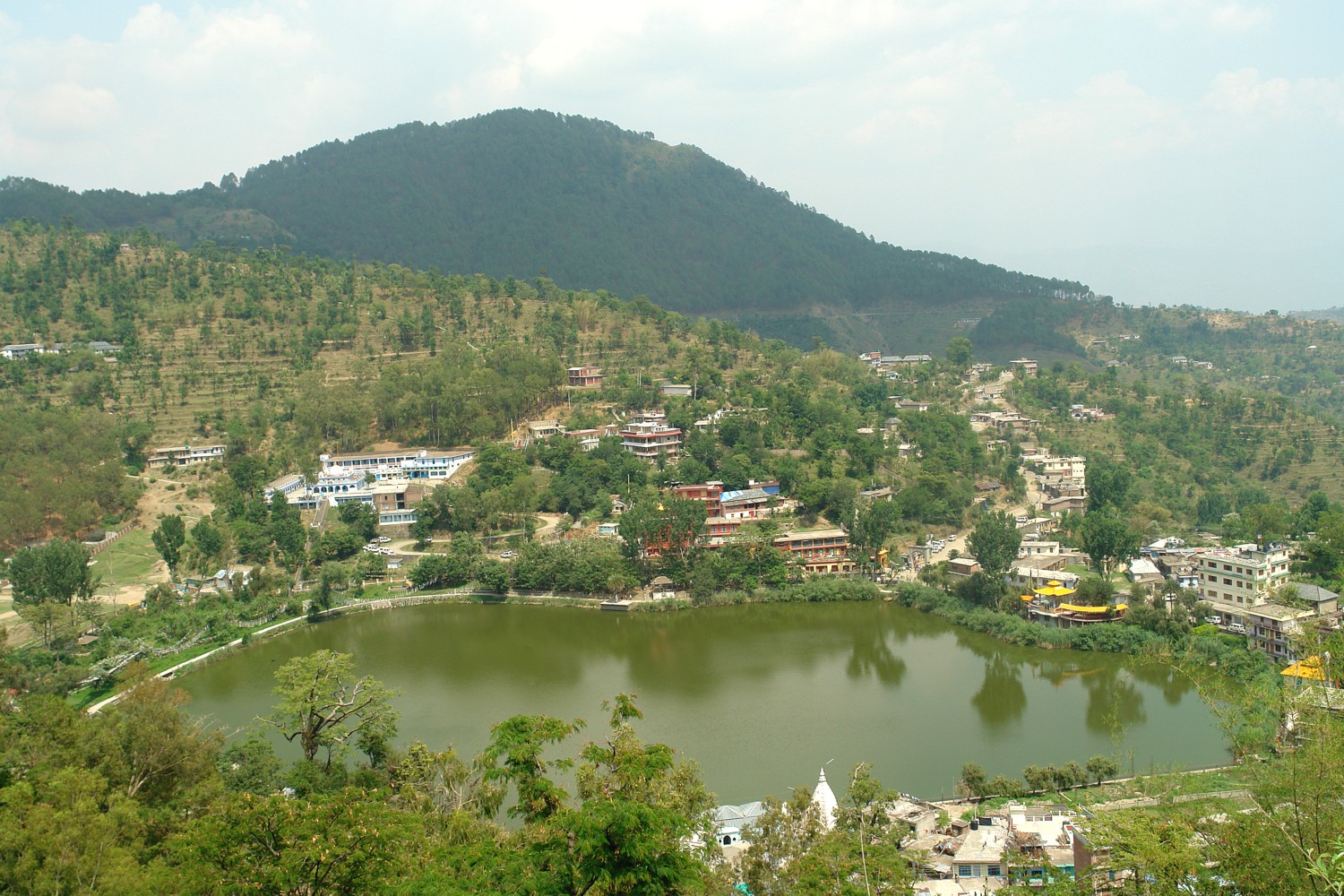
Rewalsar Lake
Mandi district (earlier known as Mandavya Nagar) is one of the central districts of Himachal Pradesh state in northern India. Mandi town is the headquarters of Mandi district Mandi. The town has both mythological and historical significance and boasts of a unique temple architecture. It is also referred to as Chhota Kashi as there are many ancient temples in the city and on the banks of river Beas. The river Beas flows through the town and hills, which makes this town more scenic. It has a serene ambiance though the modern development has made its inroads here in terms of infrastructural developments. The town is an important commercial hub of the state. It is a major transit route to Kullu-Manali and other adjoining places from both NH-21 (Chandigarh-Manali highway) and NH-20 (Pathankot-Mandi highway). Sundarnagar is one of the emerging towns of the district. Mandi has an educated middle class and people converse in Mandyali, one of the Pahari languages of Himachal.[1]
As of 2011 it is the second most populous district of Himachal Pradesh (out of 12), after Kangra.[2]
History[]
Mandi district was formed after the merger of Mandi State (Mandi) and Suket, two princely states on 15 April 1948. This coincided with the formation of the Union territory of Himachal Pradesh. It is to be mentioned that the state attained its full statehood later. Mandi town was named after its resident saint Mandavya Rishi. Mandi is situated almost at the geographical centre of Himachal, lying along the left bank of the river Beas in the foothills of Shivalik ranges. The town of Mandi has an altitude of 760 metres (2,495 ft) from the sea level. Comprising the two erstwhile states of Mandi and Suket, Mandi derives its name 'mandi' or 'market' as it was a major trade route from Ladhakh to various locations in Punjab such as Hoshiarpur and other places. Here, during the days of yore, the pious rishi, Mandavaya, performed long and severe penance and practised austerities on his body, on the bank of the river Beas, near the present Mandi town.The story indicates towards the antiquity of this beautiful temple town,surrounded by hills, clad in pines. There is a large plain which has grain fields and orchards, between Mandi and Sundernagar. Known for its temples, Mandi is the home to a number of beautiful carved stone edifices each with an elaborate shikhara, or spire, among them Bhutnath, Trilokinath, Panchvaktra and Shyamakoli at Tarna hill. Also on the hill, there is a new temple dedicated to Tarna Devi, overlooking the valley and giving a panoramic view of the whole area. The Beas valley is broad near Mandi, but there are a number of striking vales such as those of Uhl and Ran Khad. The area fruit tree cover in Mandi is about 15 per cent of the total area under fruit tree cover in Himachal Pradesh. Mandi raw-silk has acquired wide fame and the rock salt mines at Drang and Guma are also the special features of the district economy. With abundant deposit of rock salt and lime-stone, possibilities are being investigated for the existence of magnasite coal and china-clay. A transit for visitors to Kullu, Manali, Lahaul and Spiti, Dharamsala, Kangra, etc., it is approachable from Pathankot (215 km or 132 mile), Chandigarh (202km or 125 miles) and Shimla (158km or 98 miles). On either side of the road, there are rock hill sides rising perpendicularly to more than 300 metres (1,000 ft).
General information[]
- Area: 3950 km2
- Population: 901000
- Clothing: Cotton clothes in summer and woollen to heavy woollen in winter.
- Language: Hindi, English, Pahari and Mandyali are understood and spoken by the people engaged in tourism trade.
- Divisions: Divided into nine tehsils and seven sub-tehsil; Kharsog, Chachyot, Mandi Sadar Sundar Nagar[padhar] [lad bharol] [thunag] {sarkaghat] jogindernagar (sub-tehsil kotali) aut nihari [balichowki] [sandhol] [dharampur] [baldwara] ][3]
Approach[]
- Train: The nearest railway stations are Joginder Nagar and Shimla by narrow gauge train, Chandigarh and Kalka by broad gauge train which are connected by regular bus services.
- Road: Mandi is approachable by road from Shimla, Chandigarh, Pathankot and Delhi. There are regular bus services linking it to the other towns like Manali, Palampur and Dharamshala.
- Airplane: The nearest airport is at Bhuntar in Kullu District, about 50 km from the district.
Mandi Tourism[]
The historic town of Mandi (800 M) is built along the banks of the river Beas. It has long been an important commercial centre, and the sage Mandvya is said to have meditated here. This one time capital of the princely state of Mandi is a fast developing town that still retains much of its original charm and character. Today, it is a district headquarters. Mandi is renowned for its 81 old stone temples and their enormous range of fine carving. Because of this, it is often called the "Varanasi of the Hills`. The town also has the remains of old palaces and notable examples of ‘colonial’ architecture. Mandi is the gateway to the Kullu valley and acts as the base for several exciting excursions. Bhootnath Temple Practically synonymous with Mandi and located in its very heart, this is as old as the town itself, and dates back to the 1520s. In March, the festival of Shivratri is a major event and the Bhootnath temple is its focus. For and entire week the town celebrates the arrival of hundreds of local deities on elaborately decorated palanquins.
Getting There By Air
The closest airport from Mandi is Bhuntar, which is around 59 kilometers away in Kulu district.
By Rail
The closest railhead is in Kiratpur which 125 kilometers away from the town of Mandi.
'By Road'
Mandi is connected to Chandigarh by National Highway 21. The distance between Mandi & Chandigarh is 200 kilometers. Government buses are available throughout the day to Chandigarh. It takes about 5–6 hours to commute to Chandigarh by bus and around 3–4 hours if a private vehicle is taken. Mandi is also connected to Shimla, the capital of Himachal Pradesh. The distance between Shimla & Mandi is about 147 kilometers. The total time taken to commute between Shimla & Mandi is about 5 hour.
Places of interest[]
Rewalsar Lake[]
About 25 km from Mandi, 14 km from Ner Chowk is the Rewalsar lake, famous for its floating islands of reed. It is believed that all seven of them can be moved by prayer or breeze. There are three shrines here, a Buddhist Monastery, where elaborate rituals are performed, a Sikh Gurudwara and a Hindu Temple. It was from this place that the sage Padma Sambhava, a zealous teacher of Buddhism, left as a missionary to preach the doctrine of "the enlightened" in Tibet. Lying in a mountain hollow, the lake is held sacred to all three communities, boating facilities are available. Tourist inn maintained by HPTDC provide accommodation and Indian cuisine.
Prashar Lake[]
Prashar Lake lies 49 km north of Mandi, with a three storied pagoda like temple dedicated to the sage Prashar.
Joginder Nagar[]
The large hydro-electric project in Joginder Nagar has an electric trolley takes the visitor up the steep, rocky face of 2,500 metres-high (8,202 ft) mountain and drops sharply on the other side to Barot, where the reservoir is located.
The railway line goes up to the power station, the water rushing down from the reservoir at Barot in the Uhl river through penstock pipes going down nearly a thousand metres (3,280 ft). For tourists who go up to Barot by the trolley, there is a comfortable rest house of the Electricity department. The roads extend beyond to Mandi and passes the Larji gorge to the Kullu valley.
Bassi power station is five kilometres from Jogindernagar and next to it, is Machhial where fishing is not permitted as it is considered a holy sacred spot, but it is a popular as a feeding spot for fish.
ladh-bharol 25 km from joginder nagar very beautiful town,santan datri ma simsa mata mandir situated in near lad-bharol,7 km from ladh-bharol,nageshwar mahadev coudh is also situated in near bharol whre very strane gufa in near shiv mandir.
Sunder Nagar[]
Famous for its temples, 26 km from Mandi towards Shimla and at a height of 1,174 metres on the raised edge of a fertile valley, the beautiful town of Sunder Nagar is known for its shady walks amidst towering trees. On top of a hill and visited by thousands of devotees every year, is the Sukhdev Vatika and temple of Mahamaya.
The biggest hydro-electric project in all Asia, the Beas-Sutlej project, irrigating nearly one-fourth of the northern plains of India, has brought unprecedented prosperity to Sunder Nagar. The Beas-Sutlej link colony is the biggest colony in Himachal Pradesh.
Janjehli[]
At a distance of 80 km from Mandi, Janjehli is a paradise for hikers, offering treks up to a height of 3,300 metres. After covering 32 km by a motorable road up to Gohar and rest of the journey is on foot. In the midst of thick forest, forests (15 km from Gohar) is Bajahi. There is a beautiful and well furnished rest house to stay overnight, from here Janjehli is a scant 20 km away through bridle path. Chindi and Karsog are also nice places for meditation. Janlehli is also popular for adventure activities like-trekking, night safari, mountneering, skiing etc. At the distance of 10 km from janjehli the Shikari Mata temple is situated. The temple is all about Goddess "Shikari Devi" and people visits here in masses to accolades for their well being.Its a beautiful and scenariatic place with mountains seems to avoiding each other but the clouds more often use to get them in touch.
Kotli(Tungal)-''At a distance of 22 km from mandi(Mandi-Jalandhar NH-70)Famous temples:- Shiv temple Kotli,Racehra dev temple kotli And Racehra hill, Janitri devi Temple at Janitri Hill,Jhagru Dev Temple,Kasla dev and kamrawh dev temple kotli, surgani devi temple,Mahan dev temple Tej bahadur singh Temple,troka wali devi temple,Nagni devi temple etc. are very Famous. Road:-1.Mandi Jalandhar NH-70 22 km by jail Road, Talyahr.
     2. Mandi Kotli 25 km By Hospital Road, bir saigaloo.
     3. jogindarnagar-Kotli 44 km By machyali, manaroo, kun ka tar.
     4.dharmpur kotli 35 km by mandap baroti.
Lakes of Mandi district[]
- Kotli
- Bir Tungal
- Nalhog
- Baryara
- Rewalsar Lake
- Prashar Lake
- Macchial Lake
- Shiv Shambhu Lake
Demographics[]
According to the 2011 census Mandi district has a population of 999,518,[2] roughly equal to the nation of Fiji[4] or the US state of Montana.[5] This gives it a ranking of 446th in India (out of a total of 640).[2] The district has a population density of 253 inhabitants per square kilometre (660 /sq mi) .[2] Its population growth rate over the decade 2001-2011 was 10.89 %.[2] Mandi has a sex ratio of 1012 females for every 1000 males,[2] and a literacy rate of 82.81 %.[2]
Sports[]
The district is home to the Bandy Federation of India[6] which is a member of the IOC recognized[7] Federation of International Bandy. BFI plan to send a team to the 2011 Asian Winter Games. That will be the 1st time India participates in a bandy competition.
References[]
- ^ Lewis, M. Paul (2009). "Mandeali". Ethnologue: Languages of the World, Sixteenth edition. Dallas, TX: SIL International. http://www.ethnologue.com/show_language.asp?code=mjl. Retrieved 2009-10-03.
- ^ a b c d e f g "District Census 2011". Census2011.co.in. 2011. http://www.census2011.co.in/district.php. Retrieved 2011-09-30.
- ^ http://books.google.co.uk/books?id=Xd50t19YpJEC&pg=RA1-PA350&lpg=RA1-PA350&dq=Chachyot&source=bl&ots=vXoJpjCDJy&sig=qwlVDfaQJCk3_MsdE0PHBQfskBw&hl=en&ei=tAuUSrGEFsfajQe84r36DQ&sa=X&oi=book_result&ct=result&resnum=32#v=onepage&q=Chachyot&f=false
- ^ US Directorate of Intelligence. "Country Comparison:Population". https://www.cia.gov/library/publications/the-world-factbook/rankorder/2119rank.html. Retrieved 2011-10-01. "Fiji 883,125 July 2011 est."
- ^ "2010 Resident Population Data". U. S. Census Bureau. http://2010.census.gov/2010census/data/apportionment-pop-text.php. Retrieved 2011-09-30. "Montana 989,415"
- ^ http://www.internationalbandy.com/viewNavMenu.do?menuID=55
- ^ http://www.internationalbandy.com/viewNavMenu.do?menuID=4
External links[]

|
Kangra district |
| ||
| Hamirpur district | Kullu district | |||
 Mandi district | ||||
| Bilaspur district | Solan district | Shimla district |
| |||||
| Lakes | Renuka Lake | Maharana Pratap Sagar | Gobind Sagar (more...) |
|---|---|
| Rivers | Beas | Chenab | Ravi | Sutlej | Yamuna |
| Districts | Bilaspur | Chamba | Hamirpur | Kangra | Kinnaur | Kullu | Lahul and Spiti | Mandi | Sirmaur | Shimla | Solan | Una |
| Other | Climate of Himachal Pradesh | Protected areas of Himachal Pradesh | List of peaks in Himachal Pradesh |
| Sutlej Tail: Swarghat | Bilaspur | Deothsidh | |
| Beas Trail: Mandi | Rewalsar | Jogindernagar | |
| Kullu Valley Trail: Kullu | Raison | Naggar | Manali | |
| Across The Rohtang Pass: Keylong | Lahaul and Spiti | |
| This page uses content from the English language Wikipedia. The original content was at Mandi district. The list of authors can be seen in the page history. As with this Familypedia wiki, the content of Wikipedia is available under the Creative Commons License. |