| Main | Births etc |
|---|
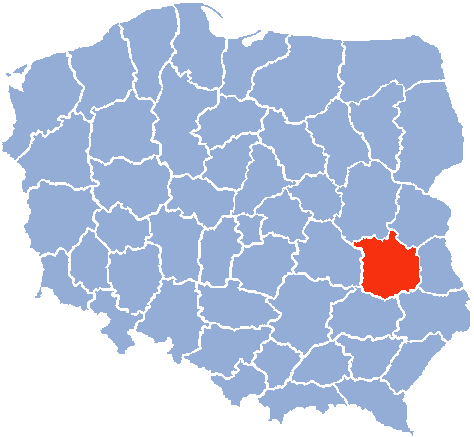
| Lublin Voivodeship Województwo lubelskie |
|||
|---|---|---|---|
| — Voivodeship — | |||
|
|||
 |
|||
 |
|||
| Coordinates (Lublin): | |||
| Country | |||
| Capital | Lublin | ||
| Counties | 4 cities, 20 land counties *
Biała Podlaska
Chełm Lublin Zamość Biała Podlaska County Biłgoraj County Chełm County Hrubieszów County Janów Lubelski County Kraśnik County Krasnystaw County Łęczna County Lubartów County Lublin County Łuków County Opole Lubelskie County Parczew County Puławy County Radzyń Podlaski County Ryki County Świdnik County Tomaszów Lubelski County Włodawa County Zamość County |
||
| Area | |||
| • Total | 25,155 km2 (9,712 sq mi) | ||
| Population (2006) | |||
| • Total | 2,175,251 | ||
| • Density | 86/km2 (220/sq mi) | ||
| • Urban | 1,014,548 | ||
| • Rural | 1,160,703 | ||
| Car plates | L | ||
| Website | http://www.lubelskie.pl/ | ||
| * further divided into 213 gminas | |||


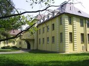
The Potocki Family Palace in Międzyrzec Podlaski
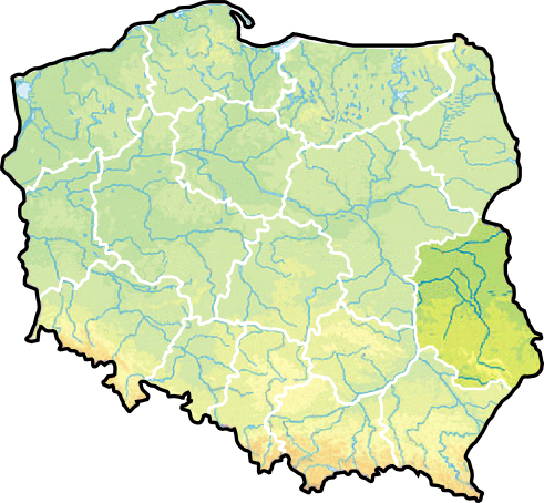
Lublin Voivodeship, or Lublin Province[1] (in Polish, województwo lubelskie [vɔjɛˈvut͡stfɔ luˈbɛlskʲɛ]), is a voivodeship, or province, in southeastern Poland. It was created on January 1, 1999, out of the former Lublin, Chełm, Zamość, Biała Podlaska and (partially) Tarnobrzeg and Siedlce Voivodeships, pursuant to Polish local government reforms adopted in 1998. The province is named after its largest city and regional capital, Lublin, and its territory is made of three historical lands: the western part of the voivodeship, with Lublin itself, belongs to Lesser Poland, the eastern part belongs to Red Ruthenia, and the northeast belongs to Polesie.
Lublin Voivodeship is bordered by Subcarpathian Voivodeship to the south, Świętokrzyskie Voivodeship to the south-west, Masovian Voivodeship to the west and north, Podlaskie Voivodeship along a short boundary to the north, and Belarus and Ukraine to the east. The province's population as of 2006 was 2,175,251. It covers an area of 25,155 square kilometres (9,712 sq mi).
History[]
The Polish historical region that encompasses Lublin, and approximates Lublin Voivodeship as it was prior to the Partitions of Poland, is known as Lubelszczyzna. Provinces centred on Lublin have existed throughout much of Poland's history; for details see the section below on Previous Lublin Voivodeships.
The region was, prior to World War II, one of the world's leading centres of Judaism. Before the middle of the 16th century, there were few Jews in the area, concentrated in Lublin, Kazimierz Dolny, and perhaps Chełm; but the founding of new private towns led to a large movement of Jews into the region to develop trade and services. Since these new towns competed with the existing towns for business, there followed a low-intensity but long lasting feeling of resentment, with failed attempts to limit the Jewish immigration. The Jews tended to settle mostly in the cities and towns, with only individual families setting up businesses in the rural regions; this urban/rural division became another factor feeding resentment of the newly arrived economic competitors. By the middle of the 18th century, Jews were a significant part of the population in Kraśnik, Lubartów and Łęczna. By the 20th century, Jews represented greater than 70% of the population in eleven towns, and close to 100% of the population of Laszczów and Izbica. From this region came both religious figures such as Mordechai Josef Leiner of Izbica, Chaim Israel Morgenstern of Puławy, and Motele Rokeach of Biugoraj, as well as famous secular authors Israel Joshua Singer. The brother of Israel, the Nobel prize winner Isaac Bashevis Singer was not born in Biugoraj, but lived part of his life in the city. The "Old Town" of the city of Lublin contained a famous yeshiva, Jewish hospital, synagogue, cemetery, and kahal, as well as the Grodzka Gate (known as the Jewish Gate).
Before the war, there were 300,000 Jews living in the region, which became the site of the Majdanek and Belzec concentration camps as well as several labour camps (Trawniki, Poniatowa, Budzyn, Puławy, Zamość, Biała Podlaska, and the Lublin work camps Lindenstraße 7 (Lipowa Street), Flugplatz, and Sportplatz) which produced military supplies for the Wehrmacht and Luftwaffe). This was once one of the biggest forced labour centres in occupied Europe, with approximately 45,000 Jewish prisoners. As well, the Sobibór extermination camp was located in the Lublin Voivodeship. After the war, the few surviving Jews largely left the area; today there is some restoration of areas of Jewish historical interest, and a surge of tourism by Jews seeking to view their families' historical roots.
Cities and towns[]
The voivodeship contains 42 cities and towns. These are listed below in descending order of population (according to official figures for 2006:[2]
|
|
|
Administrative division[]
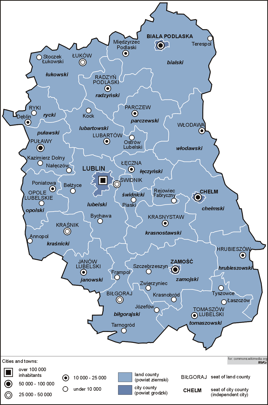
Lublin Voivodeship is divided into 24 counties (powiats): 4 city counties and 20 land counties. These are further divided into 213 gminas.
The counties are listed in the following table (ordering within categories is by decreasing population).
| English and Polish names |
Area (km²) |
Population (2006) |
Seat | Other towns | Total gminas |
| City counties | |||||
| Lublin | 147 | 354,272 | 1 | ||
| Chełm | 35 | 67,989 | 1 | ||
| Zamość | 30 | 66,613 | 1 | ||
| Biała Podlaska | 49 | 58,010 | 1 | ||
| Land counties | |||||
| Lublin County powiat lubelski |
1,679 | 140,562 | Lublin * | Bełżyce, Bychawa | 16 |
| Puławy County powiat puławski |
933 | 116,829 | Puławy | Nałęczów, Kazimierz Dolny | 11 |
| Biała Podlaska County powiat bialski |
2,754 | 113,764 | Biała Podlaska * | Międzyrzec Podlaski, Terespol | 19 |
| Zamość County powiat zamojski |
1,872 | 110,225 | Zamość * | Szczebrzeszyn, Zwierzyniec, Krasnobród | 15 |
| Łuków County powiat łukowski |
1,394 | 108,393 | Łuków | Stoczek Łukowski | 11 |
| Biłgoraj County powiat biłgorajski |
1,678 | 104,267 | Biłgoraj | Tarnogród, Józefów, Frampol | 14 |
| Kraśnik County powiat kraśnicki |
1,005 | 99,770 | Kraśnik | Annopol | 10 |
| Lubartów County powiat lubartowski |
1,290 | 90,484 | Lubartów | Kock, Ostrów Lubelski | 13 |
| Tomaszów Lubelski County powiat tomaszowski (lubelski) |
1,487 | 88,343 | Tomaszów Lubelski | Tyszowce, Łaszczów | 13 |
| Chełm County powiat chełmski |
1,780 | 79,991 | Chełm * | Rejowiec Fabryczny | 15 |
| Świdnik County powiat świdnicki (lubelski) |
469 | 72,290 | Świdnik | Piaski | 5 |
| Krasnystaw County powiat krasnostawski |
1,067 | 69,274 | Krasnystaw | 10 | |
| Hrubieszów County powiat hrubieszowski |
1,269 | 68,822 | Hrubieszów | 8 | |
| Opole Lubelskie County powiat opolski (lubelski) |
804 | 63,026 | Opole Lubelskie | Poniatowa | 7 |
| Radzyń Podlaski County powiat radzyński |
965 | 61,445 | Radzyń Podlaski | 8 | |
| Ryki County powiat rycki |
616 | 59,129 | Ryki | Dęblin | 6 |
| Łęczna County powiat łęczyński |
634 | 57,314 | Łęczna | 6 | |
| Janów Lubelski County powiat janowski |
875 | 47,875 | Janów Lubelski | 7 | |
| Włodawa County powiat włodawski |
1,256 | 40,052 | Włodawa | 8 | |
| Parczew County powiat parczewski |
953 | 36,512 | Parczew | 7 | |
| * seat not part of the county | |||||
Protected areas[]
Protected areas in Lublin Voivodeship include two National Parks and 17 Landscape Parks. These are listed below.
- Polesie National Park (this and surrounding areas form the West Polesie biosphere reserve designated by UNESCO in 2002)
- Roztocze National Park
- Chełm Landscape Park
- Janów Forests Landscape Park (partly in Subcarpathian Voivodeship)
- Kazimierz Landscape Park
- Kozłówka Landscape Park
- Krasnobród Landscape Park
- Krzczonów Landscape Park
- Łęczna Lake District Landscape Park
- Podlaskie Bug Gorge Landscape Park (partly in Masovian Voivodeship)
- Polesie Landscape Park
- Puszcza Solska Landscape Park (partly in Subcarpathian Voivodeship)
- Skierbieszów Landscape Park
- Sobibór Landscape Park
- South Roztocze Landscape Park (partly in Subcarpathian Voivodeship)
- Strzelce Landscape Park
- Szczebrzeszyn Landscape Park
- Wieprz Landscape Park
- Wrzelowiec Landscape Park
Most popular surnames in the region[]
- Wójcik: 12,937
- Mazurek: 9,644
- Mazur: 8,019
Previous Lublin Voivodeships[]
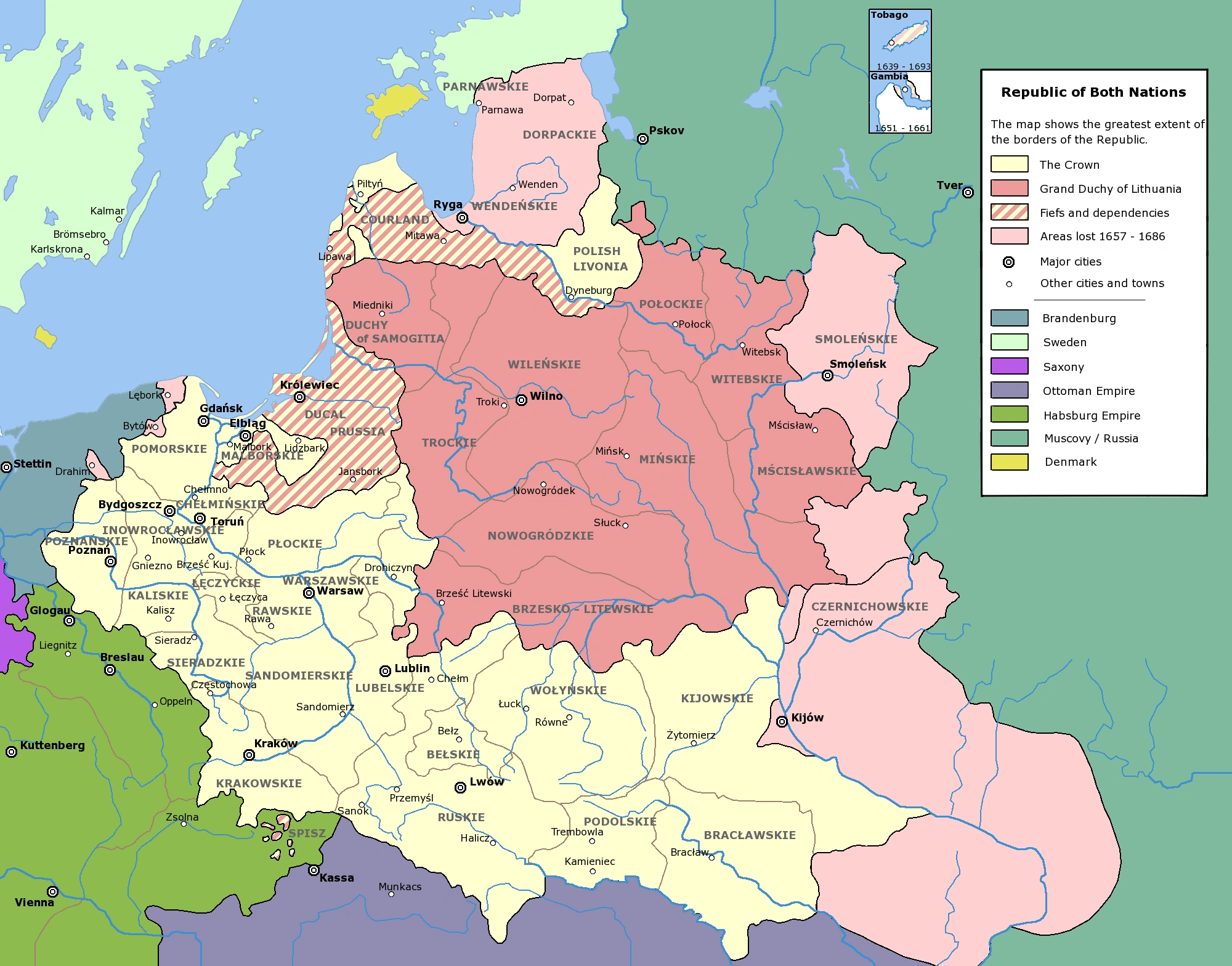
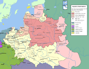
Lublin Voivodeship 1474–1795[]
- For more details on this topic, see Lublin Voivodeship (1474–1795).
Map of the Polish-Lithuanian Commonwealth
Lublin Voivodeship (Latin: Palatinatus Lublinensis; Polish: Województwo Lubelskie) was an administrative region of the Kingdom of Poland created in 1474 out of parts of Sandomierz Voivodeship and lasting until the Partitions of Poland in 1795. It was part of the prowincja of Lesser Poland.
Lublin Voivodeship 1816–1837[]
Lublin Voivodeship was one of the voivodeships of Congress Poland. It was formed in 1816 from Lublin Department, and in 1837 was transformed into Lublin Governorate.
Lublin Voivodeship 1919–1939[]
- For more details on this topic, see Lublin Voivodeship (1919–1939).
Lublin Voivodeship (Województwo Lubelskie) was one of the administrative regions of the interwar Second Polish Republic. In early 1939 its area was 26,555 square kilometres (10,253 sq mi) and its population was 2,116,200.[3] According to the 1931 census, 85.1% of its population was Polish, 10.5% Jewish, and 3% Ukrainian.
Lublin Voivodeship 1945–1975[]
Lublin Voivodeship (województwo lubelskie) was an administrative region of Poland between 1945 and 1975. In 1975 it was transformed into Chełm, Zamość, Biała Podlaska, Tarnobrzeg and Siedlce Voivodeships and a smaller Lublin Voivodeship.
Lublin Voivodeship 1975–1998[]

Lublin Voivodeship 1975–1998
Lublin Voivodeship (województwo lubelskie) existed as one of Poland's 49 voivodeships from 1975 until 1998, when it was incorporated into the current (larger) Lublin Voivodeship.
References[]
- ^ Arkadiusz Belczyk,Tłumaczenie polskich nazw geograficznych na język angielski [Translation of Polish Geographical Names into English], 2002-2006.
- ^ "Polish government statistical report, 2006". http://www.stat.gov.pl/gus/45_655_PLK_HTML.htm.
- ^ Mały Rocznik Statystyczny (Concise Statistical Year-Book), Warsaw, 1939
External links[]
- Lublin Voivodeship official website
- Adam Mickiewicz Institute page on Jewish history in the Lublin Region
Template:Lublin Voivodeship
| This page uses content from the English language Wikipedia. The original content was at Lublin Voivodeship. The list of authors can be seen in the page history. As with this Familypedia wiki, the content of Wikipedia is available under the Creative Commons License. |