| Main | Births etc |
|---|
| Lower Hutt Awakairangi (Māori) |
|
|---|---|
 |
|
| Coordinates: | |
| Country | |
| Region | Wellington |
| Territorial authority | Hutt City Council |
| Government | |
| • Mayor | Ray Wallace |
| Area | |
| • Territorial | 377 km2 (146 sq mi) |
| • Urban | 135 km2 (52 sq mi) |
| Population (June 2012 estimate)[1] | |
| • Territorial | 102,700 |
| • Density | 270/km2 (710/sq mi) |
| • Urban | 102,100 |
| • Urban density | 760/km2 (2,000/sq mi) |
| Area code(s) | 04 |
| Website | http://www.huttcity.govt.nz/ |

Lower Hutt from the air, looking eastwards.
Lower Hutt (Māori: Awakairangi) is a city in the Wellington region of New Zealand. It is the tenth largest city in New Zealand in population, and covers an area of 376.74 km².
Its council has (after a successful request for a law change) adopted the name Hutt City Council, but neither the New Zealand Geographic Board nor the Local Government Act recognise the name Hutt City. That alternative name (used on "Welcome" signs and elsewhere) has led to confusion, as there are two cities in the Hutt Valley, Lower Hutt and Upper Hutt. The Upper Hutt City Council objects to the name of Hutt City. The former Hutt County included much of the area of both Upper Hutt and Lower Hutt.
Geography[]
The city centres on the lower (southern) valley of the Hutt River, to the northeast of central Wellington. The valley widens as the river nears its mouth, so the central urban area of the city forms a triangle with its longest side along the shoreline. In the upper reaches of the city the Western and Eastern Hutt Hills become closer, culminating in the Taitā Gorge at the northern end of Lower Hutt, separating the city from neighbouring Upper Hutt.
Lower Hutt includes the cluster of small settlements that extend southward along the eastern coast of Wellington Harbour. These include the two large townships of Wainuiomata (inland) and Eastbourne (on the coast). The city also includes a large area of sparsely-populated land to the east of the harbour, extending to Pencarrow Head and into the Rimutaka Ranges.
Lower Hutt includes the islands in Wellington Harbour, the largest of which, Matiu/Somes Island, is commonly referred to by its former name of Somes Island.
Events stated to have happened in Lower Hutt before 1989 would almost certainly have been in the original smaller city area, not in Eastbourne, Petone, or Wainuiomata. Those suburbs are still recognised localities in the Wellington Region.
Climate[]
| Climate data for Lower Hutt | |||||||||||||
|---|---|---|---|---|---|---|---|---|---|---|---|---|---|
| Month | Jan | Feb | Mar | Apr | May | Jun | Jul | Aug | Sep | Oct | Nov | Dec | Year |
| Record high °C (°F) | 28.8 (83.8) |
30.9 (87.6) |
28.6 (83.5) |
26.5 (79.7) |
23.0 (73.4) |
19.6 (67.3) |
18.2 (64.8) |
20.1 (68.2) |
24.3 (75.7) |
23.6 (74.5) |
27.5 (81.5) |
29.6 (85.3) |
30.9 (87.6) |
| Average high °C (°F) | 22.5 (72.5) |
22.6 (72.7) |
20.9 (69.6) |
18.4 (65.1) |
15.9 (60.6) |
13.4 (56.1) |
12.8 (55.0) |
13.8 (56.8) |
15.7 (60.3) |
16.9 (62.4) |
18.7 (65.7) |
20.7 (69.3) |
17.69 (63.85) |
| Daily mean °C (°F) | 18.2 (64.8) |
18.3 (64.9) |
16.6 (61.9) |
14.1 (57.4) |
12.1 (53.8) |
9.9 (49.8) |
9.0 (48.2) |
9.9 (49.8) |
11.6 (52.9) |
13.0 (55.4) |
14.5 (58.1) |
16.7 (62.1) |
13.66 (56.58) |
| Average low °C (°F) | 14.0 (57.2) |
14.0 (57.2) |
12.2 (54.0) |
9.8 (49.6) |
8.3 (46.9) |
6.3 (43.3) |
5.2 (41.4) |
6.0 (42.8) |
7.6 (45.7) |
9.1 (48.4) |
10.4 (50.7) |
12.8 (55.0) |
9.64 (49.36) |
| Record low °C (°F) | 5.2 (41.4) |
5.0 (41.0) |
4.6 (40.3) |
2.5 (36.5) |
0.0 (32.0) |
−1.9 (28.6) |
−3.3 (26.1) |
−1.1 (30.0) |
−2.2 (28.0) |
0.8 (33.4) |
2.1 (35.8) |
5.0 (41.0) |
−3.3 (26.1) |
| Precipitation mm (inches) | 84 (3.31) |
81 (3.19) |
87 (3.43) |
88 (3.46) |
117 (4.61) |
154 (6.06) |
144 (5.67) |
136 (5.35) |
109 (4.29) |
145 (5.71) |
99 (3.9) |
94 (3.7) |
1,338 (52.68) |
| Mean monthly sunshine hours | 235 | 199 | 198 | 159 | 135 | 105 | 124 | 146 | 156 | 176 | 192 | 204 | 2,029 |
| Source: Paradise.net [2] | |||||||||||||
Hutt River[]
Lower Hutt occupies the lower regions of the flood plain of the Hutt River, and the river is one of the most significant features of the city. In the 20th century stopbanks were built to contain the river, but the threat of flooding from heavy rainfall persists. In 1985 the river burst its banks, but since then floods have been on a smaller scale. Smaller streams and storm-water drains have also caused occasional problems when rainfall persistently exceeds average levels.
Much of the land adjacent to the river is protected as reserve and provides a much-appreciated recreational feature, with walking tracks and grassed areas over approximately 12 km of river bank.
Pollution levels in the river have been consistently high since urbanisation of the Hutt Valley. Frequent algal blooms have contributed to making slow flowing areas anoxic and have caused localised 'dead zones'. The algal blooms have been attributed as the cause of death of many dogs swimming in the river as well as severe skin reactions in the case of swimmers.
The river is crossed by seven bridges within the city, heading downstream:
- Silverstream Rail Bridge.
- Taita Rail Bridge.
- Kennedy-Good Bridge, a two-lane road bridge that was opened in 1979 and was the first bridge at this site. The bridge is named after the Mayor of Lower Hutt at that time.
- Melling Bridge, a three-lane bridge (one eastbound, two westbound) that was opened 1957. This is the second bridge at this site, the first being a one-lane suspension bridge opened in 1909, approximately 200 metres upstream.
- Ewen Bridge is the seventh bridge at this site and was opened in 1996. The preceding bridges were opened in 1844, 1847, 1856, 1872, 1904 & 1929.
- The 'Rail Bridge', a two-track rail bridge with pedestrian walkway. Opened 1927.
- Estuary or Pipe Bridge, a two-lane road bridge that also carries a pipe for the supply of water to Wellington.
Population[]
The urban area of Lower Hutt (including Wainuiomata and Eastbourne) had a population of 102,100 at the June 2012 estimate.[1]
Suburbs[]
- North of the Central Business District (CBD)
- Avalon; Belmont; Boulcott; Epuni; Fairfield; Harbour View; Kelson; Manor Park; Melling; Naenae; Normandale; Pomare; Stokes Valley; Taitā; Tirohanga; Wingate
- South of the CBD
- Alicetown; Ava; Gracefield; Korokoro; Maungaraki; Moera; Petone; Waiwhetū; Waterloo; Woburn
- Wainuiomata
- Arakura; Glendale; Homedale; Parkway
- Eastern harbour
- Days Bay; Eastbourne; Lowry Bay; York Bay; Mahina Bay; Muritai; Point Howard; Rona Bay; Seaview
History[]
Before European settlement, the Hutt Valley was thickly forested, with areas of marshland close to the river's mouth. Māori inhabited the shoreline, with a pa at each end of Petone beach.
The Māori welcomed the arrival of the New Zealand Company ship Tory in 1839, and William Wakefield (the company's agent) negotiated with local chiefs to allow settlement.
The first immigrant ship, the Aurora, arrived on 22 January 1840, still celebrated every year as Wellington's Anniversary Day (though "Mondayised"). The settlement, Britannia, was established close to the mouth of the Hutt River, and settlers established the country's first newspaper and bank.
The city takes its name from the river, which was named after the founding member, director and chairman of the New Zealand Company, Sir William Hutt.

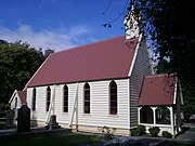
Christ Church, Taitā, built in 1853, is the oldest church in the Wellington region.
Within months of settlement the river flooded, and the settlers decided to move the new colony to Thorndon, in what is now the heart of Wellington, though some settlers remained at the north end of the harbour.
In 1846 there was conflict between settlers and Māori, which led to skirmishes. In 1855 a major earthquake raised part of the lower valley, allowing land to be reclaimed from swamp.
The arrival of the railway from Wellington in 1874 and the subsequent location of the railway's engineering works at Woburn in 1929 led to a rapid expansion of the area's population and economy. Other industries were soon attracted to the district.
The present boundaries of the local body have evolved from a series of amalgamations and boundary changes over the years.
The Hutt County Council was established in 1877 and covered the region from Wellington’s south coast up to Waikanae, excluding Wellington City Council area. As the region grew, urban parts of the Hutt county became autonomous boroughs: Petone in 1888, Lower Hutt in 1891, Eastbourne in 1906, Johnsonville in 1908, Upper Hutt in 1908, Porirua in 1962 (with the western part of the county becoming Makara County) and Kapiti in 1974.
In 1941 Lower Hutt became a city. It was extended to cover Normandale in 1957.
In 1987-89 the Government forced local authorities to consolidate, which led to Lower Hutt amalgamating with the adjacent Boroughs of Petone and Eastbourne and the Wainuiomata District (which had its own independence for barely a year) and the abolition of the Hutt County Council.
Culture and leisure[]
Several education and research facilities of national significance are in the southern half of the city. Cultural facilities include the Dowse Art Gallery (now called TheNewDowse)[1] and the former Avalon Television studios, now used primarily as a paintball arena.
The city possesses civic administration buildings constructed in the 1950s that are regarded as representative architecture of the era. A building of national significance is Vogel House, a two-storey wooden residence that was the official residence of the Prime Minister of New Zealand for much of the 20th century. It is a prime example of early colonial architecture in New Zealand and operates today as a tourist attraction and function venue.
The city is popular for outdoor sports, especially mountain biking, hiking, recreational walking and fishing. Fishing is however increasingly discouraged in Lower Hutt, due to high pollution levels and frequent toxic algal blooms in the Hutt River.
Lower Hutt hosted the 2012 Australasian Police and Emergency Services Games, a weeklong event of 40 sports, since Christchurch could not host in the wake of the 2011 earthquake.
Among the filming locations for The Lord of the Rings film trilogy directed by Peter Jackson, Dry Creek quarry, which dominates the hills above Taitā Gorge near Belmont, became the site for a huge mediaeval castle built for scenes of Helm’s Deep and Minas Tirith.
Economy[]
Historically, Petone and nearby parts of Lower Hutt acted as the principal area for light industry in this region, with industries including meat processing and freezing, motor vehicle assembly, and timber processing. This activity has been significantly diminished or discontinued in recent decades with either the transfer of industrial activity to the more heavily populated area of Auckland or cessation at a national level. Such movement has often resulted from competitive pressures on commercial organisations for increased efficiency, as a result of opening up the New Zealand economy to international competition since the mid-1980s.
Trends over the past 25 years have seen service, distribution, and consumer-oriented activity replace the industrial activity previously a feature of the Petone area. Lower Hutt is the main location for light industrial activity in the Wellington Region, but it largely lacks heavy industry.
A significant proportion of Lower Hutt's population commutes to commercial and Government workplaces in Wellington 12 km to the south-west.
Today Lower Hutt is home to leading Crown Research Institutes such as GNS Science and Industrial Research Ltd (IRL) along with many other cutting-edge research organisations in high-end manufacturing, research and technology.[3]
The Civil Aviation Authority of New Zealand (CAA) has its headquarters in Aviation House in Petone, Lower Hutt.[4]
Government[]
Ray Wallace was elected Hutt City mayor in 2010, succeeding David Ogden.
Flora and fauna[]
Hills to about 350 m (1000 ft) line both sides of the valley within the city limits. The western hills have been populated as residential areas, but the eastern side is protected and clad in native bush and scrub, and the ubiquitous gorse in areas that have been cleared as a result of scrub fires or earlier human activity.
Native birds are common, including the New Zealand Pigeon, Tui, Grey Fantail, Silvereye, Shining Cuckoo (in season), Grey Warbler and Morepork. Introduced species include the Common Blackbird, Song Thrush, House Sparrow, European Goldfinch, Common Chaffinch, Common Starling, and Australian Magpie.
Sister-city relationships[]
Lower Hutt has five sister cities:[5]
 Laredo, Texas, The United States of America
- Minoh City, Japan
- Taizhou, China
- Tempe, Arizona, The United States of America
- Xi'an, China
Tempe was the first Sister City, in 1981; Laredo the most recent, in 2011.
Panoramas[]

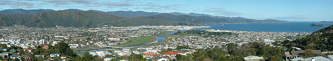
Lower Hutt from Normandale, in the western hills. On the right is the entrance to Wellington Harbour, with Matiu/Somes Island beneath. The Hutt River snakes from the left mid-ground to the right background, entering the harbour between the suburbs of Seaview and Petone. The Wainuiomata Hill Road climbs the hills in the centre background (the track in the middle of the left half of the background is a firebreak, not a road). At the foot of the Wainuiomata Hill Road is the Gracefield industrial area.


Wider view of the Lower Hutt valley. This view shows Wellington in the distance on the extreme right hand side. Past the Lower Hutt CBD in the centre of the photo, and onto Avalon and Taitā on the left-hand side.


Lower Hutt from the top of the Wainuiomata hills. This viewpoint can be seen in the top panorama by following the ridgeline left from the top of the Wainuiomata Hill Road to the first major firebreak

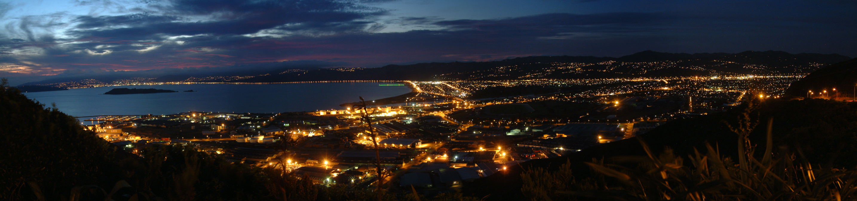
Wellington Harbour and southern Lower Hutt from the top of the Wainuiomata Hill Road (south of the above photo), looking west. Matiu/Somes Island is in the harbour on the left (South), and beyond that the row of lights along State Highway 2, marking the line of the geologic fault, both of which continue up the far side of the valley to the right. The industrial area in the central foreground is Gracefield. In the distance, behind Matiu/Somes Island, are Wellington port and CBD.
References[]
- ^ a b "Subnational population estimates at 30 June 2012". Statistics New Zealand. 23 October 2012. http://www.stats.govt.nz/browse_for_stats/population/estimates_and_projections/subnational-pop-estimates-tables.aspx. Retrieved 23 October 2012. Also "Infoshare; Group: Population Estimates - DPE; Table: Estimated Resident Population for Urban Areas, at 30 June (1996+) (Annual-Jun)". Statistics New Zealand. 19 December 2012. http://www.stats.govt.nz/infoshare/SelectVariables.aspx?pxID=2f5a6aa2-7aeb-4792-a34a-d5567eb8082f. Retrieved 23 October 2012.
- ^ "Climate Statistics for Lower Hutt, NZ (1985-2010)". http://homepages.paradise.net.nz/tmcgavin/lh_stats.html. Retrieved January 27, 2012.
- ^ http://huttcity.govt.nz/en/Our-City/Business-in-the-Hutt/
- ^ "Contacting the CAA." Civil Aviation Authority of New Zealand. Retrieved on 28 September 2010.
- ^ Lower Hutt Sister Cities Website
External links[]
- Hutt City Council
- Hutt City i-SITE
- Lower Hutt City (Name of City Council) Act 1991
- Maungaraki website
- HuttCam website
| |||||||||||||||||||
| This page uses content from the English language Wikipedia. The original content was at Lower Hutt. The list of authors can be seen in the page history. As with this Familypedia wiki, the content of Wikipedia is available under the Creative Commons License. |