| ||||||||||||||
| Lorain County, Ohio | |
 Location in the state of Ohio | |
 Ohio's location in the U.S. | |
| Founded | December 26 1822[1] |
|---|---|
| Named for | Lorraine in France |
| Seat | Elyria |
| Largest city | Lorain |
| Area - Total - Land - Water |
923 sq mi (2,391 km²) 492 sq mi (1,276 km²) 431 sq mi (1,115 km²), 46.64% |
| Population - (2000) - Density |
284,664 578/sq mi (223/km²) |
| Website | www.loraincounty.us |
Lorain County is a county located in the U.S. state of Ohio, and is considered to be a part of what is locally referred to as Greater Cleveland. As of the 2000 census, its population is 284,664. Named by early settler Heman Ely for the French province of Lorraine, its county seat is Elyria and its largest community is the Lake Erie port city of Lorain.[2]
Geography
According to the U.S. Census Bureau, the county has a total area of 2,391 km² (923 sq mi). 1,276 km² (492 sq mi) of it is land and 1,115 km² (431 sq mi) of it (46.64%) is water.
Major highways
In Lorain County, the most important highways are Interstates 80 and 90 (the Ohio Turnpike) and 480. Other highways include U.S. Routes 6 and 20 and State Routes 2, 10, 18, 57, 58, 83, 82, 113, 162, 254, 301, 303, 511, and 611.
Adjacent counties
- Across Lake Erie lies the province of Ontario, Canada (north)
- Cuyahoga County (east)
- Medina County (southeast)
- Ashland County (south)
- Huron County (southwest)
- Erie County (west)
Demographics

Old county building in Elyria, Ohio.
As of the census² of 2000, there were 284,664 people, 105,836 households, and 76,201 families residing in the county. The population density was 223/km² (578/sq mi). There were 111,368 housing units at an average density of 87/km² (226/sq mi). The racial makeup of the county was 85.54% White, 16.2% Black or African American, 0.30% Native American, 0.60% Asian, 0.03% Pacific Islander, 2.87% from other races, and 2.17% from two or more races. 6.91% of the population were Hispanic or Latino of any race.
There were 105,836 households out of which 33.60% had children under the age of 18 living with them, 55.20% were married couples living together, 12.60% had a female householder with no husband present, and 28.00% were non-families. 23.60% of all households were made up of individuals and 9.20% had someone living alone who was 65 years of age or older. The average household size was 2.61 and the average family size was 3.08.
In the county, the population was spread out with 26.20% under the age of 18, 8.70% from 18 to 24, 29.30% from 25 to 44, 23.30% from 45 to 64, and 12.50% who were 65 years of age or older. The median age was 36 years. For every 100 females there were 96.30 males. For every 100 females age 18 and over, there were 93.60 males.
The median income for a household in the county was $45,042, and the median income for a family was $52,856. Males had a median income of $39,902 versus $26,116 for females. The per capita income for the county was $21,054. About 6.70% of families and 9.00% of the population were below the poverty line, including 12.90% of those under age 18 and 6.60% of those age 65 or over.

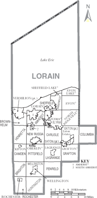
Map of Lorain County, Ohio With Municipal and Township Labels
Government
Main article: Ohio county government.
Localities
Cities
Villages
Townships
Census-designated place
Other place
Education
Higher Education
- Lorain County Community College, Elyria
- Oberlin College, Oberlin
Public School Districts
There are 20 public school districts in Lorain County. Those primarily in Lorain County are listed in bold. Each district's high school(s) and location is also listed.
- Amherst Exempted Village School District
- Amherst Marion L. Steele High School, Amherst
- Avon Local School District
- Avon High School, Avon
- Avon Lake City School District
- Avon Lake High School, Avon Lake
- Black River Local School District (also in Medina Co and Ashland Co.)
- Black River High School, Sullivan
- Clearview Local School District
- Clearview High School, Sheffield Twp (South Lorain)
- Columbia Local School District
- Columbia High School, Columbia Station
- Elyria City School District
- Elyria High School, Elyria
- Firelands Local School District (also in Erie Co.)
- Firelands High School, South Amherst
- Keystone Local School District
- Keystone High School, LaGrange
- Lorain City School District
- Lorain Admiral King High School, Lorain
- Lorain Southview High School, Lorain
- Mapleton Local School District (Primarily in Ashland Co.)
- Mapleton High School, Ashland
- Midview Local School District
- Midview High School, Grafton
- New London Local School District (primarily in Huron Co.)
- New London High School, New London
- North Ridgeville City School District
- North Ridgeville High School, North Ridgeville
- Oberlin City School District
- Oberlin High School, Oberlin
- Olmsted Falls City Schools (primarily in Cuyahoga Co.)
- Olmsted Falls High School, Olmsted Falls
- Sheffield-Sheffield Lake City School District
- Brookside High School, Sheffield
- Strongsville City School District (primarily in Cuyahoga Co.)
- Strongsville High School, Strongsville
- Vermilion Local Schools (primarily in Erie Co.)
- Vermilion High School, Vermilion
- Wellington Exempted Village School District (also in Huron Co.)
- Wellington High School, Wellington
Private High Schools
- Elyria Catholic High School, Elyria
- Lake Ridge Academy, North Ridgeville
- Open Door Christian Academy, Elyria
- Christian Community School, North Eaton
References
- ^ "Ohio County Profiles: Lorain County" (PDF). Ohio Department of Development. http://www.odod.state.oh.us/research/FILES/S0/Lorain.pdf. Retrieved 2007-04-28.
- ^ {{cite web|url = http://www.osuedc.org/profiles/profile_entrance.php?fips=39093&sid=0 |title = Lorain County data |accessdate = 2007-04-28 |publisher = Ohio State University
- Lorain County Government's website
- Lorain County Sheriff's Office
- Lorain County Historical Society's website
- Lorain County History Project
See also
| ||||||||||||||||||||||||||

| This page uses content from the English language Wikipedia. The original content was at Lorain County, Ohio. The list of authors can be seen in the page history. As with this Familypedia wiki, the content of Wikipedia is available under the Creative Commons License. |