| London Borough of Sutton | |||
|---|---|---|---|
| — London borough — | |||
|
|||
 |
|||
| Sovereign state | United Kingdom | ||
| Constituent country | England | ||
| Region | London | ||
| Ceremonial county | Greater London | ||
| Status | London borough | ||
| Admin HQ | Sutton | ||
| Incorporated | 1 April 1965 | ||
| Government | |||
| • Type | London borough council | ||
| • Body | Sutton London Borough Council | ||
| • Leadership | Leader & Cabinet (Liberal Democrat) | ||
| • Mayor | Councillor Sean Brennan | ||
| • MPs | Tom Brake Paul Burstow |
||
| • London Assembly | Steve O'Connell AM for Croydon and Sutton | ||
| • EU Parliament | London | ||
| Area | |||
| • Total | 16.93 sq mi (43.85 km2) | ||
| Area rank | 282nd (of 326) | ||
| Population (2006 est.) | |||
| • Total | 191,100 | ||
| • Rank | 88th (of 326) | ||
| • Ethnicity[1] | 80.0% White British 1.9% White Irish 4.3% Other White 0.8% White & Black Caribbean 0.3% White & Black African 0.8% White & Asian 0.6% Other Mixed 2.7% Indian 0.9% Pakistani 0.4% Bangladeshi 1.8% Other Asian 1.4% Black Caribbean 1.8% Black African 0.3% Other Black 0.8% Chinese 1.2% Other |
||
| Time zone | GMT (UTC0) | ||
| • Summer (DST) | BST (UTC+1) | ||
| Postcodes | {{{postcode_areas}}} | ||
| Police force | Metropolitan Police | ||
| Website | sutton.gov.uk | ||
The London Borough of Sutton (![]() pronunciation (help·info)) is a London borough in South London, England and forms part of Outer London. It covers an area of 43 km2 (17 sq mi) and is the 80th largest local authority in England by population. It is one of the southernmost boroughs of London. It is south of the London Borough of Merton, west of the London Borough of Croydon and east of the Royal Borough of Kingston Upon Thames. The local authority is Sutton London Borough Council. Its principal town is the eponymous Sutton.
pronunciation (help·info)) is a London borough in South London, England and forms part of Outer London. It covers an area of 43 km2 (17 sq mi) and is the 80th largest local authority in England by population. It is one of the southernmost boroughs of London. It is south of the London Borough of Merton, west of the London Borough of Croydon and east of the Royal Borough of Kingston Upon Thames. The local authority is Sutton London Borough Council. Its principal town is the eponymous Sutton.
History[]
The borough was formed in 1965 by the merger of the Municipal Borough of Sutton and Cheam with the Municipal Borough of Beddington and Wallington and Carshalton Urban District which had previously been part of Surrey.
Districts[]
The borough includes the areas:
- Bandon Hill
- Beddington
- Beddington Corner
- Belmont
- Benhilton
- Carshalton
- Carshalton Beeches
- Carshalton on the Hill
- Cheam
- Hackbridge
- Little Woodcote
- North Cheam
- Rosehill
- St. Helier
- South Beddington
- Sutton
- Sutton High Street
- The Wrythe
- Wallington
- Woodcote Green
- Worcester Park
Surrounding area[]

|
Kingston | Morden | Mitcham |
|
| Ewell | Croydon | |||
 Sutton | ||||
| Epsom | Banstead | Purley |
Cultural attractions and institutions[]


Charles Cryer Theatre, Carshalton
The London Borough of Sutton used to be a collection of rural villages, linked to feudal and royal estates. The "village feel" remains, and people still refer to locations such as Carshalton, Cheam and Belmont as villages. The historic development of the borough is reflected in the number of heritage areas designated as conservation areas and as areas of special local character. Descriptions of a selection of the borough's cultural institutions and attractions are set out below.
The Charles Cryer Theatre, Carshalton[]
There are frequent productions at The Charles Cryer Studio Theatre, which is situated on the High Street (number 39) in Carshalton Village. As well as drama and musicals, productions include comedy and dance. With material ranging from Shakespeare to Chekov to panto and children's favourites, the theatre's aim is to balance popularity with quality. The theatre also serves as a concert venue for local bands and has played host to the popular local Rockshot festival. The theatre is named after the man who led the campaign to open the Secombe Theatre, Sutton, listed below. The theatre building also incorporates a Thai restaurant.
The Secombe Theatre, Sutton town centre[]
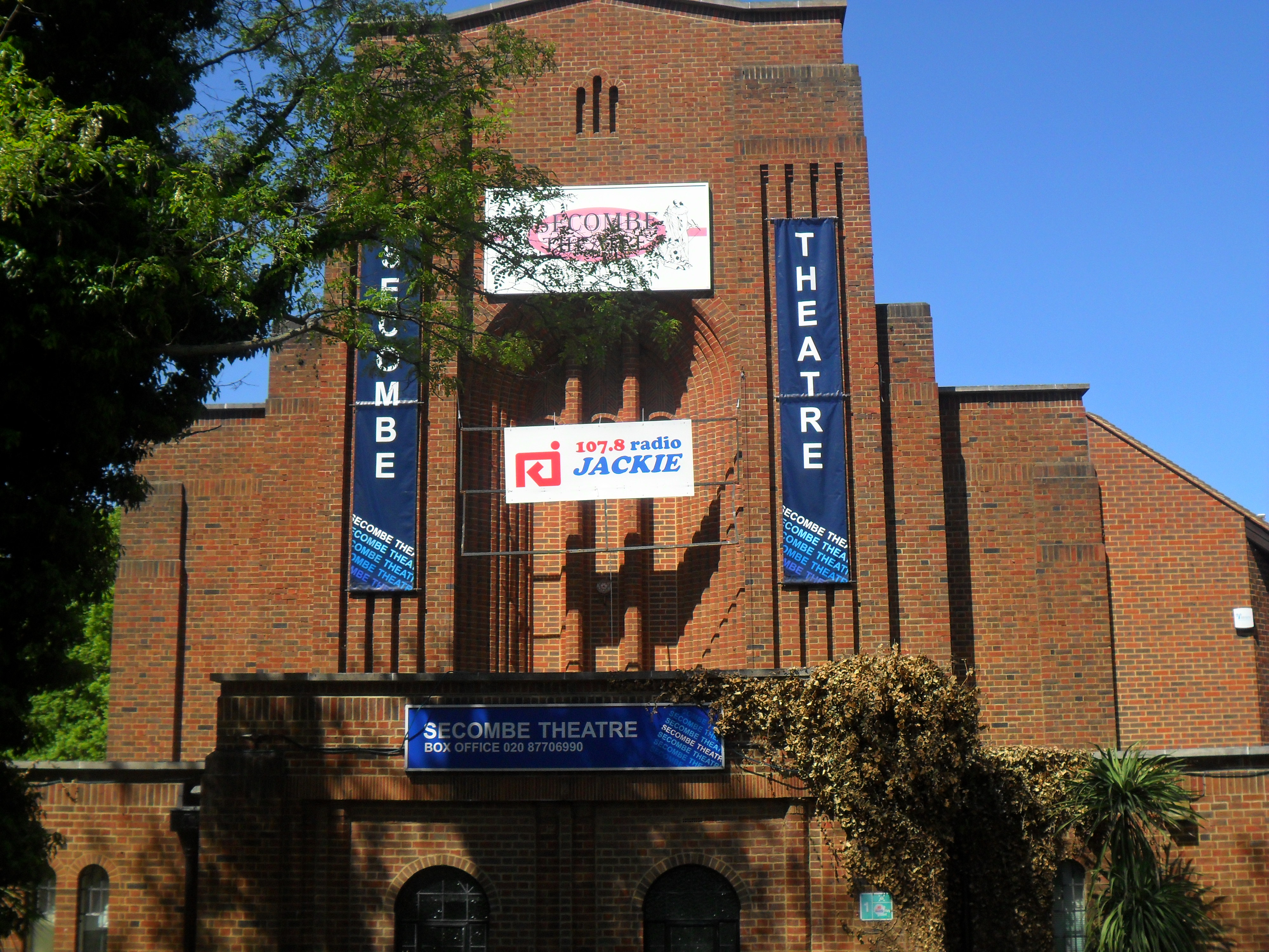

.JPG)
Secombe Theatre, Sutton town centre.
The Secombe Centre theatre (named after Sir Harry Secombe) is in Cheam Road, adjacent to the Holiday Inn Hotel. The theatre was opened by Sir Harry in 1983, who lived in Sutton for over 30 years of his life.[2] The theatre was created out of a former Christian Scientist church building.[3] The main auditorium seats 340, and there is a large multi-purpose function room attached. The Secombe Theatre is operated in conjunction with the Charles Cryer Studio Theatre, named after the man who led the campaign to open the Secombe Theatre. (The Charles Cryer Studio is in a converted hall in nearby Carshalton – see entry above). Productions at the Secombe range in content from modern productions to new twists on older more established plays. Some productions are produced locally, while others come as part of touring groups. From time to time comedians and musicians appear at the theatre.
Sutton Library, Sutton town centre[]
Sutton Library is situated close to the top of the town, near St Nicholas Church and the Holiday Inn Hotel, and is part of a complex which contains the Civic Offices, home of Sutton Borough Council, and the Sutton College of Liberal Arts. It is the largest library in the borough. Originally opened in 1975, it was extensively refurbished in 2004 to meet changing customer needs. It was the first public library to appoint a library writer-in-residence; the first to establish a CD and video lending library; and the first to offer a full public library service on Sundays. The library is arranged over four storeys, and the lending and reference facilities extend to a reader's lounge; café and shop; IT facilities; opportunities to listen to music; and a children's library themed around the world's environments.[4]
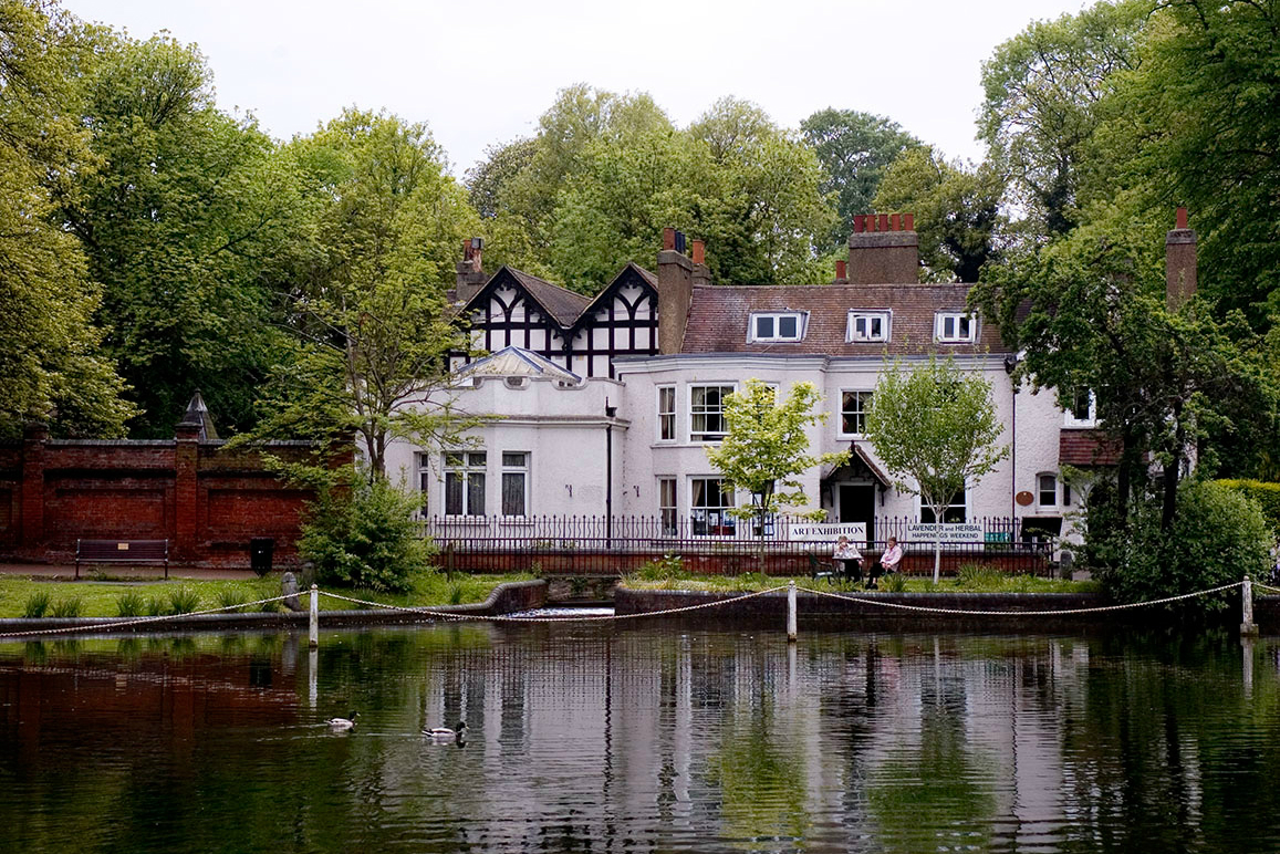
Carew Manor, Beddington[]


Carew Manor
Beddington Park is the location of Carew Manor which was the home of the Carew family. The Grade I listed banqueting hall,[5] which boasts a fine hammerbeam roof, survives from the original house along with part of the orangery built by Sir Francis Carew and claimed to be the first in England. In the grounds is an early 18th-century Grade II* listed dovecote.[6] Archaeologists have recently discovered a Tudor garden including a grotto at Carew Manor, believed to have been created by Sir Francis Carew in the 16th century. There are tours of the banqueting hall organised by the London Borough of Sutton Museum & Heritage Service.
Little Holland House, Carshalton[]
Little Holland House in Carshalton Beeches was the home of the artist Frank Dickinson (1874–1961). Dickinson's Arts and Crafts style interior was influenced by John Ruskin and textile designer and artist William Morris. The house contains many of his art works. Admission is free and the house is open 1.30–5.30pm the first Sunday of each month plus Bank Holiday Sundays and Mondays.
Church of St Mary the Virgin, Beddington, Sutton[]


St Mary's Church, Beddington
The Grade II listed 14th Century flint parish church of St Mary's occupies a prominent position in Beddington Park, immediately south of what is now Carew Manor School and which was from the late Middle Ages the seat of the Carew family. It contains an organ screen by William Morris. The church is designated at Grade II for the following principal reasons:[7]
- It has substantial amounts of fabric from the 14th and 15th centuries
- It was extensively restored and provided with an extremely elaborate and interesting mid-Victorian decorative scheme.
- It has monuments and other fixtures of importance from circa 1200 to the 20th century, including font and Carew tombs.
- The Morris and Co. organ is of special note, and the Last Judgment reredos is unusual.
Sutton Life Centre, Sutton[]
The Sutton Life Centre is an £8 million community facility designed to improve life chances for younger people and encourage good citizenship. Its key feature – the lifezone – is a virtual street, a room with screens on all walls showing real-life scenes from Sutton's streets. It also has a library, a café, a climbing wall, and community, eco, sports, youth and media zones.[8] It tries to encourage community engagement and involvement. It was opened on 27 October 2010 by Deputy Prime Minister Nick Clegg.[9]
Honeywood Museum, Carshalton[]

Honeywood Museum
Honeywood is a large house at the western end of Carshalton Ponds. At its earliest it dates from the 17th century but has been much extended and restored, particularly in the period 1896 to 1903 when a large Edwardian wing was added to the south side. It now houses the London Borough of Sutton's main Museum and has a local history collection, including objects that date back to the Bronze Age. The museum has recently been refurbished, reopening in May 2012 with enhanced features. Among others improvements, there are now expanded displays about the river Wandle and its influence on the life of the area, including an interactive map. The house is open Wed-Fri 11am-5pm, Sat, Sun & Bank Holidays 10am-5pm. Admission free.
Sutton Arts Council[]
Sutton Arts Council exists to support and promote the arts, broadly defined, within the Borough. Managed by a small Executive Committee of volunteers, it currently has around eighty member societies covering a wide range of arts and heritage interests – dramatic and operatic, musical and choral, artistic and photographic, ethnic, linguistic and historical.[10]
Public Art in Sutton town centre[]


Sutton Heritage Mural
There are a number of examples of public art in Sutton town centre, ranging from building-height murals, to sculptures to an armillary. These are all fully described in the article on the town of Sutton itself. Of particular borough-wide note is one of the murals, which is in the form of a mosaic measuring 9 metres (30 feet) in height and 5 metres (16 feet approximately) in width, and covering the whole of a three-storey wall in the town square near the Waterstones bookshop. It was commissioned to celebrate Sutton's main heritage sites, and shows several aspects of the borough's heritage and local history in a geometric pattern of nineteen panels. The centre-piece is the depiction of Henry VIII's palace at Nonsuch. Other panels depict armorial bearers from the old local families, as well as industrial and architectural heritage.[11]
Whitehall Gallery, Cheam[]
Whitehall is a timber framed and weatherboarded house in the centre of Cheam Village. It was originally built in about 1500 as a wattle and daub yeoman farmer's house but has been much extended. The external weatherboarded appearance dates from the 18th century. In the garden there is a medieval well which served an earlier building on the site. Now an historic house museum, the building features a period kitchen, and house details from the Georgian, Victorian and Edwardian eras. There is a programme of events and changing exhibitions in the house, which also has displays about the history of the house and its inhabitants, nearby Cheam School, and Henry VIII's Nonsuch Palace. Admission is free and the house is open on Wednesday, Thursday, Friday, Sunday and Bank Holidays from 2pm to 5pm; and on Saturday from 10am to 5pm.
Nonsuch Mansion, Cheam[]
Nonsuch Mansion is a Gothic revival mansion within Nonsuch Park. The service wing is occasionally open to the public. It is a popular place for wedding receptions, as it is available for hire. In medieval times it was part of the three thousand acre manor of Cuddington. The mansion was originally built in 1731–43 by Joseph Thompson and later bought by Samuel Farmer in 1799. He employed Jeffry Wyattville to rebuild it in a Tudor Gothic style in 1802-6. Farmer was succeeded by his grandson in 1838 under whom the gardens became famous. Nonsuch Mansion bears a resemblance in its design to the original design of Nonsuch Palace, whose construction was begun by King Henry VIII in the 16th Century. Built within the north porch of the mansion is a block from the original Nonsuch Palace that bears an inscription which means "1543 Henry VIII in the 35th year of His reign."
Governance[]
Local council seat distribution as of May 2010:
| Party | Seats | |
|---|---|---|
| Liberal Democrat | 43 | |
| Conservative | 11 | |
| Independent | ||
| Total | 54 | |
The main local government of the borough is Sutton London Borough Council. The Council has had a Liberal Democrat administration since 1986. From 1965–1986 Conservatives administered the council. At the London local elections, 2010 the Liberal Democrats returned 43 councillors, the Conservatives 11 and the Labour Party lost all of its seats on the council.
Councillor Ruth Dombey is the Leader of the Council. The Leader of the Opposition is Councillor Graham Whitham and Deputy Leader of the Opposition: Councillor Tim Crowley. Graham Tope, later Lord Tope was the Leader of the Council from 1986 to 1999.
- National Politics
Sutton is divided into two parliamentary constituencies, Sutton and Cheam and Carshalton and Wallington with one MP each:
| Party | Member of Parliament | Constituency | |
|---|---|---|---|
| Liberal Democrat | Paul Burstow, a former local councillor, replaced Conservative Olga Maitland in the 1997 General Election | Sutton and Cheam | |
| Liberal Democrat | Tom Brake, replaced Conservative Nigel Forman in the 1997 General Election | Carshalton and Wallington | |
- London Assembly
As the London Assembly has eleven London-wide members from all four main parties, the borough shares its geographical London Assembly member with neighbouring Croydon, in its elections which began in 2000 and take place with the election of the Mayor of London, a Conservative Assembly member has gained a large majority (in other words it is arguably a safe seat). The current Assembly Member is Steve O'Connell, then a local councillor from Croydon, who was elected with an increased share of the vote of 43% following fellow conservative Andrew Pelling's time representing the area.
- European Parliament
Sutton is represented in the European Parliament by the London constituency.
Notable individuals[]
Notable individuals closely associated with the borough:


Joan Armatrading in the 1970s. It was during that decade that the singer-songwriter lived in Sutton


Sir Nicholas Carew, courtier
The first Rolling Stones album, which was recorded exactly one year on from their historic Sutton gig
- Joan Armatrading, singer-songwriter & musician, lived in Sutton in the 1970s.
- Harry Aikines Aryeetey, athlete, attended Greenshaw High School
- Terry and Jonathan Austen, micronation creators
- Jeff Beck, musician
- Seb Brown, AFC Wimbledon goalkeeper, attended Cheam High School
- Angus Calder, writer, historian and academic
- Rob Davis, Lead Guitarist of Mud
- Lord Peter Ritchie Calder, author, journalist and academic
- Sir Nicholas Carew, sheriff of Surrey and Sussex, Master of the King's Horse, executed by Henry VIII
- Sir Francis Carew, grandson of the above, of Beddington Park, Elizabethan horticulturalist
- James Cracknell OBE, Olympic gold medallist in rowing
- Quentin Crisp, writer, author, raconteur
- Clark Datchler, lead singer of Johnny Hates Jazz
- Sir John Fellows(c. 1671–1724), of the South Sea Company
- Eddie George later Lord George (1938–2009) GBE DL, PC,(16 September 1938 – 18 April 2009), Governor of the Bank of England 1993–2003.
- Les Gray, lead vocalist of Mud
- Lord Hardwicke, (1690–1764) Lord Chancellor[12]
- Darius Henderson, footballer
- Sir John Major KG CH, former Conservative Prime Minister
- Simon Conway Morris, palaeontologist, specifically research of Burgess Shale type fauna
- Peter Loader, cricketer
- Gary Mason, boxer
- Katie Melua, singer, songwriter, and musician
- David Mitchell (born 1980), cricketer
- Dave Mount, drummer of Mud
- Dr John Radcliffe, royal physician and MP see Radcliffe Camera, Radcliffe Infirmary and the Radcliffe Observatory[12]
- Sir Cliff Richard, singer and songwriter, attended Stanley Park Junior School
- Leo Richardson, writer/actor, attended Stanley Park Junior & High School
- The Rolling Stones were discovered at the then Red Lion pub (now the Winning Post) in Sutton.[13] It was also at the pub that, on 23 January 1963, Charlie Watts and Bill Wyman became permanent members of The Rolling Stones.[14]
- Rebecca Romero, Olympic cycling champion
- Sir William Scawen, merchant who purchased Carshalton manor
- Sir Harry Secombe, singer, comedian and entertainer. Member of the Goon Show cast.
- Jack Simmons, historian
- Cardiacs, Tim Smith (Cardiacs) musician
- Alec Stewart OBE, cricketer
- Neil Sullivan, footballer
- Sarah Tullamore, actress and singer
- Tim Vine, actor and comedian
- Joanna Rowsell, Olympic gold medallist in women's pursuit cycling
- David Weir MBE, multi-Olympic gold medallist, Paralympic athlete
- Joshua Pascoe, Played Ben Mitchell on Eastenders
- Helen Young, BBC Weather Presenter and former BBC Weather Centre Manager
Education[]

Saint Philomena's School
The London Borough of Sutton is an exceptionally high performing borough for education. Five of the state secondary schools in the London Borough of Sutton are Grammar schools. There is also one exceptionally high-performing Catholic day school; this is St Philomena's School. The comprehensives perform well above the national average – see citations below.
The Borough came top of the England GCSE league tables in 2011 on the key benchmark – the percentage of pupils achieving five good GCSEs (A* to C) including English and Mathematics. The national average for 2011 was 58.2%. The average for Sutton, at 74.7%, was more than 15% above this national average. Only three other local authorities were able to achieve an average above 70%, all lower than Sutton. (See Sutton Guardian, 31 Jan 2012).[15]
In 2013 Sutton schools bucked the national trend and performed even better than in 2012. 83.9% of pupils achieved five A* to C GCSE grades in subjects including Maths and English compared with 75.6% in 2012.[16]
Environment[]


BedZED

BedZED's colourful roofs
The London Borough of Sutton is home to a number of notable environmental projects, including the following.
- BedZED (Beddington Zero Energy Development)
The acclaimed BedZED (Beddington Zero Energy Development) housing complex is located on London Road, SM6, about 500 yards north of Hackbridge mainline railway station. It utilises a number of innovative technologies to enable it to operate with zero energy use. It was designed by the architect Bill Dunster to support a more sustainable lifestyle. The project was led by the Peabody Trust in partnership with Bill Dunster Architects, Ellis & Moore Consulting Engineers, BioRegional, Arup and the cost consultants Gardiner and Theobald.
The 99 homes, and 1,405 square metres of work space were built between 2000 and 2002. It is the UK's largest and first carbon-neutral eco-community. The buildings are constructed of materials that store heat during warm conditions and release heat at cooler times, and where possible, they have been built from natural, recycled or reclaimed materials. The first residents moved in (to the Helios Road part of the development) during March 2002.
BedZED receives power from a small-scale combined heat and power plant (CHP). In conventional energy generation, the heat that is produced as a by-product of generating electricity is lost. With CHP technology, this heat can be harnessed and put to use. At BedZED, the heat from the CHP provides hot water, which is distributed around the site via a district heating system of super-insulated pipes. Should residents or workers require a heating boost, each home or office has a domestic hot water tank that doubles as a radiator.
The CHP plant at BedZED is powered by off-cuts from tree surgery waste that would otherwise go to landfill. Wood is a carbon neutral fuel because the CO2 released when the wood is burned is equal to that absorbed by the tree as it grew.
The development has attracted wide interest and acclaim over the past decade since it was built, and, has won numerous awards. Among other examples of recognition, it was shortlisted for the Stirling Prize for architecture in October 2003, and won awards from the London Evening Standard and RIBA in 2002.
- Carshalton Environmental Fair
The Environmental Fair is held in Carshalton Park on August Bank Holiday Monday.[17] It features over 100 stalls and showcases local sustainability initiatives. It also includes music, performing art, poetry, children's activities, campaign groups, local craft, interactive demonstrations, and a farmers' market. Music is performed from three stages and across the genres from rock to folk. The main stage is a natural open-air amphitheatre. There is food and a bar with real ales. The fair attracts on average around 10,000 people. It is organised by EcoLocal with a team of volunteers.
- Sutton Ecology Centre
The Sutton Ecology Centre is located in the Carshalton Village part of Sutton borough.[18] It is an area of mainly open space where visitors can find out about wildlife habitats, alternative energy, recycling, composting, and organic gardening. The Centre's activities include running educational visits for schools and community groups, as well as events and volunteer days.
The history of the Ecology Centre is that the grounds were until the late eighties known as the "Lodgelands", named after the old gardens of The Lodge in Carshalton. They were used as a tree nursery until the early eighties, when they became surplus to requirements. After a prolonged public debate, it was agreed in 1987 to preserve the area as an open space for public use.
Transport[]
The main forms of public transport used in the borough are surface rail from its various regional railway stations and local buses.
Sutton has frequent, direct Commuter rail services to central London stations, including London Victoria (approx 26 minutes travelling time depending on service), London Bridge and several Thameslink stations, including St Pancras (the Eurostar terminus). Sutton borough also has quick access to the London Underground with the Northern Line in neighbouring Merton borough easy to reach by several local bus services. In addition, the recent London Overground network, completed circa 2010, is only 5 to 10 minutes away from Sutton borough stations at neighbouring Croydon borough station West Croydon. Sutton borough may also join up fully with the nearby London Tramlink that currently serves places like Croydon and Wimbledon, with discussions about it becoming part of this network now (2013) at a fairly advanced stage.
National and international travel[]
Sutton is linked into the national motorway network via the A217 and M25 orbital motorway at Junction 8. The M25 skirts the south of the borough, linking Sutton with other parts London and the surrounding counties. The A24 passes through the north western part of the borough, through North Cheam and onto Epsom, Dorking, Horsham, Worthing, Bognor Regis and Chichester. This follows, in part, the course of Stane Street, an old Roman road linking London and Chichester. The A232 links Sutton with other towns in the borough, also the boroughs of Kingston, Croydon and Bromley.

Sutton railway station
The Sutton and Mole Valley Lines railway route south from Sutton links the borough to Sussex and Surrey to the south, and to central London to the north: providing direct services to Dorking, Epsom, Horsham, Leatherhead, Wimbledon, Croydon and Wandsworth. Also running through Sutton is the Sutton Loop Thameslink line which links Luton and St Pancras International directly with the stations on the loop. The main station for all these services is Sutton railway station to the south of the town. The station is the largest and busiest in Sutton. Passenger rail services through Croydon are provided by Southern, First Capital Connect and South West Trains.[19] A pilot scheme launched by the Strategic Rail Authority, Transport for London and three train operators is designed to encourage more passengers to travel off-peak. In full partnership with the South London Boroughs which includes Sutton, SWELTRAC, SELTRANS and the transport users group, the scheme promotes the advantages of off-peak travel following improvements to safety, travel connections and upgrading of station facilities. The Thameslink Programme (formerly known as Thameslink 2000), is a £3.5 billion major project to expand the Thameslink network from 51 to 172 stations[20] spreading northwards to Bedford, Peterborough, Cambridge and King's Lynn and southwards to Guildford, Eastbourne, Horsham, Hove to Littlehampton, East Grinstead, Ashford and Dartford. The project includes the lengthening of platforms, station remodelling, new railway infrastructure (e.g. viaduct) and additional rolling stock.
Sutton is located about 15 miles (24 km) from both London Heathrow Airport and London Gatwick Airport. Heathrow is served by London Buses route X26 and Gatwick by the National Express Coaches A3 route, which stops outside Sutton railway station. Luton Airport, about 40 miles (64 km) to the north, is connected to Sutton by a direct train. Croydon Airport which was partly in the borough of Sutton served as London's main airport in the years prior to the second world war but closed in the 1950s.
Local travel[]
The hilly topography of Sutton and the lack of underground services in South London is a reason for the extensive suburban and inter-urban railway network. Sutton is in the commuter belt to London as part of suburbia. There are several busy local rail routes running along the borough's towns, connecting it with London Bridge, St. Pancras International (the Eurostar terminus) and London Victoria. These local routes mainly run on the Sutton Loop and Sutton & Mole Valley Lines. As well as the main station of Sutton, there are several suburban stations at Hackbridge, West Sutton, Carshalton and Cheam and more.
A sizeable bus infrastructure which is part of the London Buses network operates from a main hub on the Sutton one-way system. London General, owned by the Go-Ahead Group, is one of the largest bus operators to serve Sutton along with Metrobus, Abellio London, Transdev London, Quality Line, and National Express London. Unlike other places in the country, London's transport infrastructure is regulated and therefore is not subject to price wars between different companies with TfL setting a standard price for bus services which is currently £1.35 with an Oyster card and free for all under 12s. Services include buses to central London, Croydon, Wimbledon, Kingston and a number of other civic centres in the south. London Buses route X26, the longest route in London, provides services between Heathrow airport and Croydon via Kingston.
Although hilly, Sutton is compact and has few major trunk roads running through it. It is on one of the National Cycle Network route running around South London.[21] The North Downs, an area of outstanding natural beauty popular with both on and off-road cyclists, is so close to Sutton that part of the park lies within the borough boundary, and there are routes into the park almost from the civic centre.
Construction of the East London line extension to West Croydon was completed circa 2010. Sutton borough has easy access to this tube extension via its frequent and quick services to West Croydon station (along various other routes into central London) – for instance the journey time from Sutton mainline station to West Croydon station is 10 minutes. There are, in addition, hopes that Sutton will be connected to the London Overground scheme through Orbirail and TfL's interest in bidding for the South London Lines operated by Southern until 2009 when a new South Central franchise will be awarded.[22] Parliamentary approval to construct a railway line from Wimbledon to Sutton through what were then undeveloped rural areas had been obtained by the Wimbledon and Sutton Railway (W&SR) in 1910. The main supporters of the scheme were the London Brighton and South Coast Railway (LB&SCR), the London and South Western Railway (L&SWR) and the Metropolitan District Railway (MDR, now London Underground's District Line). All held shares in the company and had rights to run trains over the line when built. World War I prevented any work taking place and by the early 1920s continuing financial support from the MDR meant that it had effectively taken control of the company. Through its ownership of the MDR, the London Electric Railway (LER, precursor of London Underground) was able to obtain approval to use part of the route for an extension of the City and South London Railway (C&SLR, now the Northern Line) from Clapham Common through Morden to Sutton. The route would have seen Underground Northern Line trains running on surface tracks from Morden past the nearby Underground depot and on to the Network Rail alignment close to Morden South. The Southern Railway (SR, successor of the L&SWR and the LB&SCR after the 1923 Grouping of railways) objected to this encroachment into its area of operation and the loss of its passenger traffic to a more direct route. The two companies reached an agreement that enabled the C&SLR to extend as far as Morden in exchange for the LER giving up its rights over the W&SR route. The SR subsequently built the line, one of the last to be built in the London area. It opened on 5 January 1930.
In March 2011, the main forms of transport that residents used to travel to work were: driving a car or van, 33.1% of all residents aged 16–74; train, 6.6%; bus, minibus or coach, 6.6%; on foot, 5.6%; underground, metro, light rail, tram, 3.9%; work mainly at or from home, 3.1%; passenger in a car or van, 2.0%.[23]
Parks[]


Fountain in Manor Park, Sutton Town Centre
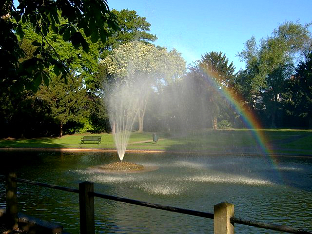

Rainbow at the fountain at Elms Pond, at the junction of Butter Hill with London Road, Carshalton


The western edge of Sutton Green
In total, the London Borough of Sutton has 89 parks and open spaces within it boundaries, representing a total area of 1,500 acres (6.1 km2).
Varied in size and layout, green spaces range from the compact Manor Park in Sutton town centre (see first photo in section) and Sutton Green just to the north of Sutton town centre (see third photo), through the medium-sized Grove Park, which forms a notable part of the Carshalton conservation area, to the large and historic Oaks Park in the south of the borough.
Just to the north of Sutton town centre there is more extensive green space in the form of Sutton Common, which originally (until the beginning of the nineteenth century) encompassed the aforementioned Sutton Green. Today, a small portion of Sutton Common is given over to a major junior tennis facility. The Common extends both to the east and west of Angel Hill.
Slightly further in the opposite direction out of Sutton lie Banstead Common and Banstead Downs—these start a few hundred yards from the southern end of the town, and extend for an additional mile south in the direction of neighbouring Banstead.
As indicated above Oaks Park has a long history. It was substantially laid out for the Earl of Derby nearly 250 years ago – in the 1770s – but its villa dates back further than that. The villa (for one Thomas Gosling) was built around 1750, in the era's fashionable landscape style, with trees forming a perimeter screen and placed in artful clumps to suggest a natural landscape. The house was partly rebuilt by Robert Taylor (architect) for John Burgoyne in 1775 and by Robert Adam for the 12th Earl of Derby in 1790.[24] The villa's bakehouse, stable block and some outbuildings remain to this day.
The main parks in the borough are:
- Beddington Park
- Carshalton Park
- Cheam Park
- Grove Park
- Lakeside
- Manor Park, Sutton town centre
- Nonsuch Park
- Oaks Park
- Overton Park
- Poulter Park Poulter Park
- Mellow's Park
- Queen Mary's Park
- Roundshaw Down
- Royston Park
- Seer's Park
- St Helier Open Space
- The Wandle Walkway
Sports facilities and clubs[]
Football club Sutton United F.C. are based in Sutton, who play in the Conference South. Carshalton has two football clubs: Carshalton Athletic F.C. (home ground at The War Memorial Sports Ground, Colston Avenue, and play in the Ryman League) and Carshalton FC (at Beddington Park).
Wallington has a Non-League football club Crescent Rovers F.C. who play at the Wallington Sports & Social Club.
The Croydon Pirates despite their name play just inside the borough of Sutton, at Waddon and are one of the most successful teams in the British Baseball Federation.
Sutton Cricket Club[25] is based in Cheam Road, Sutton, (entrance in Gander Green Lane.) The Club's 1st XI plays at the highest level of the sport available to it, the England & Wales Cricket Board's, 'Surrey Championship Premier Division.’
Mitcham Rugby Union Football Club[26] plays out of Poulter Park in Carshalton, Wandle Valley ward. Mitcham RUFC play in the Surrey RFU Leagues. Poulter Park also boasts three Gaelic clubs that use Mitcham RUFC as a base for training and playing games Round Towers GAA, Senior Gaelic Football Club,[27] Sean Treacy's Hurling Club[28] and Croydon Camogie Club.[29]
Rosehill boasts an ETTA premier level Table Tennis Club, Rosehil TTC[30] who play in the Sutton & District League and the Thames Valley League.
At the Westcroft Leisure Centre, in Carshalton there are health and fitness facilities including two swimming pools, sports hall, squash court and fitness centre.[31] Westcroft is also home to Sutton Pumas basketball club. The Westcroft Centre was given a major (£11 million) refurbishment and new look during 2012. There are also two public basketball courts in the Rosehill section of Sutton borough.
The Sutton and Epsom Weightlifting Club meet at Sutton Arena near to St Hellier's Hospital to the North of Sutton.
Climate[]
Sutton has a temperate climate in common with most areas of Great Britain, it is similar to that of Greenwich in Inner London: its Köppen climate classification is Cfb.[32][33] Its mean annual temperature of 9.6 °C is similar to that experienced throughout the Weald, and slightly cooler than nearby areas such as the Sussex coast and central London.[34] Rainfall is considerably below England's average (1971–2000) level of 838 mm, and every month is drier overall than the England average.[35]
The nearest weather station is at Gatwick Airport.[36][37]
| Climate data for London Borough of Sutton | |||||||||||||
|---|---|---|---|---|---|---|---|---|---|---|---|---|---|
| Month | Jan | Feb | Mar | Apr | May | Jun | Jul | Aug | Sep | Oct | Nov | Dec | Year |
| Average high °F | 44 | 45 | 49 | 54 | 61 | 66 | 71 | 71 | 65 | 58 | 50 | 46 | 49 |
| Average low °F | 34 | 34 | 36 | 38 | 44 | 50 | 53 | 52 | 48 | 44 | 48 | 36 | 42 |
| Precipitation inches | 1.2 | 1.2 | 1.6 | 1.2 | 1.6 | 1.2 | 1.6 | 1.6 | 2.8 | 2 | 2 | 2.4 | 1.996 |
| Average high °C | 6 | 7 | 9 | 12 | 16 | 18 | 21 | 21 | 18 | 14 | 10 | 8 | 9 |
| Average low °C | 1 | 1 | 2 | 3 | 7 | 10 | 12 | 11 | 9 | 7 | 3 | 2 | 9 |
| Precipitation cm | 3 | 3 | 4 | 3 | 4 | 3 | 4 | 4 | 7 | 5 | 5 | 6 | 5.07 |
| Source: Weatherbase[38] | |||||||||||||
Town twinning[]
 Gagny in France
- Gladsaxe in Denmark
- Minden in Germany
- Charlottenburg-Wilmersdorf in Germany
- Tavernelle in Italy
References[]
- ^ Data Management and Analysis Group, Greater London Authority, Demography Update October 2007, (2007)
- ^ Harry Secombe. Welsh Icons. Retrieved on 2013-07-17.
- ^ http://www.overthefootlights.co.uk/20.pdf
- ^ London Borough of Sutton – Sutton Central Library. Sutton.gov.uk. Retrieved on 2013-07-17.
- ^ Beddington Place (Great Hall Only) – Sutton – Greater London – England. British Listed Buildings. Retrieved on 2013-07-17.
- ^ Pigeon House to North West of Beddington Place – Sutton – Greater London – England. British Listed Buildings. Retrieved on 2013-07-17.
- ^ Parish Church of St Mary the Virgin, Sutton
- ^ "Sutton Life Centre", sutton.gov.uk. Retrieved 1 March 2011.
- ^ "Deputy Prime Minister Nick Clegg officially opened Sutton Life Centre", Sutton Guardian, 27 October 2010. Retrieved 1 March 2011.
- ^ Sutton Arts Council. Sutton Arts Council. Retrieved on 2013-07-17.
- ^ Drostle and Turner fine tiles — Sutton Heritage page
- ^ a b H.E. Malden (editor) (1912). "Parishes: Carshalton". A History of the County of Surrey: Volume 4. Institute of Historical Research. http://www.british-history.ac.uk/report.aspx?compid=43049. Retrieved 29 November 2012.
- ^ http://www.shadyoldlady.com/location.php?loc=2521#
- ^ http://www.timeisonourside.com/chron1963.html
- ^ SUTTON TOPS GCSE LEAGUE TABLES (From Your Local Guardian). Yourlocalguardian.co.uk (31 January 2012). Retrieved on 2013-07-17.
- ^ http://www.suttonguardian.co.uk/news/10627865.LIVE__Sutton_GCSE_results_day_2013/
- ^ "Carshalton Environmental Fair". http://www.ecolocal.org.uk/.
- ^ London Borough of Sutton – Sutton Ecology Centre. Sutton.gov.uk. Retrieved on 2013-07-17.
- ^ "UK rail network map" (PDF). National Rail website. National Rail. 2006. Archived from the original on 30 May 2008. http://web.archive.org/web/20080530154955/http://www.nationalrail.co.uk/system/galleries/download/print_maps/Nat_Rail_Passenger_Operators_2006.pdf. Retrieved 25 May 2008.
- ^ "Good news for South London as £3.5BN Thameslink project clears major hurdle" (Press release). 18 October 2006. http://www.networkrailmediacentre.co.uk/Content/Detail.asp?ReleaseID=2413&NewsAreaID=2&SearchCategoryID=8. Retrieved 12 April 2007.
- ^ "Areas to cycle in Sutton". 2008. http://www.sustrans.org.uk/default.asp?sRegion=London&map.x=-0.190751345688503&map.y=51.3519798680984&bLarge=&nZoom=3. Retrieved 24 May 2008.
- ^ Next Stop South London – The Londonder, 08/03/08
- ^ "2011 Census: QS701EW Method of travel to work, local authorities in England and Wales". Office for National Statistics. http://www.ons.gov.uk/ons/rel/census/2011-census/key-statistics-and-quick-statistics-for-wards-and-output-areas-in-england-and-wales/rft-qs701ew.xls. Retrieved 23 November 2013. Percentages are of all residents aged 16–74 including those not in employment. Respondents could only pick one mode, specified as the journey's longest part by distance.
- ^ "The Oaks & Oaks Park, London Borough of Sutton". http://www.sutton.gov.uk/leisure/heritage/Carshalton/oaksandpark.htm.
- ^ Sutton Cricket Club
- ^ Mitcham Rugby Union Football Club
- ^ Round Towers GAA, Senior Gaelic Football Club
- ^ Sean Treacy's Hurling Club
- ^ Croydon Camogie Club
- ^ Rosehil TTC
- ^ "L.B. Sutton – Westcroft Leisure Centre.". http://www.sutton.gov.uk/leisure/leisurecentres/westcroft.htm.
- ^ WorldClimate
- ^ (Temperature data)
- ^ "Mean Temperature Annual Average". Met Office. 2001. http://www.metoffice.gov.uk/climate/uk/averages/19712000/tmean/17.gif. Retrieved 22 August 2007.
- ^ "Met Office: averages 1971–2000". Met Office website. Met Office. 2007. http://www.metoffice.gov.uk/climate/uk/averages/19712000/areal/england.html. Retrieved 22 August 2007.
- ^ (Rainfall data)
- ^ (Pressure data)
Temperature and rainfall: 1961–1990 averages. Pressure averages: 1971–1988 averages.
Derived from the Global Historical Climatology Network (version 1). - ^ "Weatherbase: Historical Weather for London, England". http://www.weatherbase.com/weather/weather.php3?s=67730&refer=. Retrieved 2 November 2007.
External links[]
Official
News and travel
| Wikivoyage has a travel guide for London/South_West. |
Culture
Community
Maps
- Geo Links for London Borough of Sutton
- Coordinates: Geo Links
Open data about London Borough of Sutton
Template:LB Sutton
| |||||||||||||||||
| This page uses content from the English language Wikipedia. The original content was at London Borough of Sutton. The list of authors can be seen in the page history. As with this Familypedia wiki, the content of Wikipedia is available under the Creative Commons License. |