| London Borough of Southwark | |||
|---|---|---|---|
| — London borough — | |||
|
|||
| Motto: United to Serve | |||
 |
|||
| Sovereign state | United Kingdom | ||
| Constituent country | England | ||
| Region | London | ||
| Ceremonial county | Greater London | ||
| Status | London borough | ||
| Admin HQ | Tooley Street, Southwark | ||
| Incorporated | 1 April 1965 | ||
| Government | |||
| • Type | London borough council | ||
| • Body | Southwark London Borough Council | ||
| • Leadership | Leader & Cabinet (Labour) | ||
| • Mayor | — (non-political) | ||
| • MPs | Harriet Harman Simon Hughes Tessa Jowell |
||
| • London Assembly | Valerie Shawcross AM for Lambeth and Southwark | ||
| • EU Parliament | London | ||
| Area | |||
| • Total | 11.14 sq mi (28.85 km2) | ||
| Area rank | 312th (of 326) | ||
| Population (2006 est.) | |||
| • Total | 288,700 | ||
| • Rank | 35th (of 326) | ||
| • Ethnicity[1] | 52.6% White British 2.6% White Irish 9.1% Other White 1.2% White & Black Caribbean 0.8% White & Black African 0.7% White & Asian 1.1% Other Mixed 2.6% Indian 0.6% Pakistani 1.6% Bangladeshi 0.9% Other Asian 6.9% Black Caribbean 13.3% Black African 1.7% Other Black 2.6% Chinese 1.6% Other |
||
| Time zone | GMT (UTC0) | ||
| • Summer (DST) | BST (UTC+1) | ||
| Postcodes | |||
| Police force | Metropolitan Police | ||
| Website | southwark.gov.uk | ||
The London Borough of Southwark /ˈsʌðərk/[2] is a London borough in south east London. It is directly south of the River Thames and the City of London, and forms part of Inner London.
History[]
The area was first settled in the Roman period but the name Southwark dates from the 9th century. The London Borough of Southwark was formed in 1965 from the former area of the Metropolitan Borough of Southwark, the Metropolitan Borough of Camberwell, and the Metropolitan Borough of Bermondsey.
Geography[]
The borough borders the City of London and the London Borough of Tower Hamlets to the north (the River Thames forming the boundary), the London Borough of Lambeth to the west and the London Borough of Lewisham to the east. To the south are the London Borough of Bromley and the London Borough of Croydon.
Demographics[]
At the 2001 census Southwark had a population of 244,866. Southwark is ethnically 63% white, 16% black African and 8% black Caribbean. 31% of householders are owner–occupiers.
Landmarks[]
Tower Bridge, the Millennium Bridge, Blackfriars Bridge, Southwark Bridge and London Bridge all connect the City of London to the borough. The skyscraper Shard London Bridge is currently the tallest building in the EU. The Tate Modern art gallery, Shakespeare's Globe Theatre, the Imperial War Museum and Borough Market are also within the borough.
Religion[]
Southwark has many notable places of Christian worship, Anglican, Roman Catholic and independent non-conformist. These include Charles Spurgeon's Metropolitan Tabernacle, Southwark Cathedral (Church of England), St George's Cathedral (Roman Catholic), and St Mary's Cathedral (Greek Orthodox). London's Norwegian Church and Finnish Church and the Swedish Seamen's Church are all in Rotherhithe. St George the Martyr is the oldest church in Greater London dedicated to England's Patron Saint, the redundant St Thomas Church is now the Old Operating Theatre Museum and Herb Garret. The other redundant church is Francis Bedford's in Trinity Church Square, now a recording studio, Henry Wood Hall.
Whilst Christianity is the dominant religion of the borough, several religious minorities are also active, and places of worship for Sikhs, Muslims, Hindus and Jews may be found.[3]
According to the 2001 Census, approximately 28% of Southwark identified as non-religious, or chose not to state their faith.[4]
Literature and theatres[]
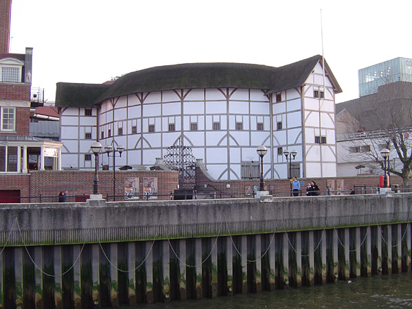
The rebuilt Globe Theatre
Southwark has many literary associations. Charles Dickens set several of his novels in the old borough where he lived as a young man. The site of The Tabard inn (featured in Chaucer's Canterbury Tales), the White Hart inn and the George Inn which survives.
The rebuilt Globe Theatre and its exhibition on the Bankside remind us of the area's being the birthplace of classical theatre. There is also the remains of the Rose Theatre. In 2007 the Unicorn Theatre for Children was opened on Tooley Street with both the Southwark Playhouse and the Union Theatre having premises in Bermondsey Street. The Menier Chocolate Factory combines a theatre and exhibition space.
Museums and galleries[]
The borough is the location of international-standard museums and galleries; the Imperial War Museum and its outpost HMS Belfast moored at the Pool, Dulwich Picture Gallery the oldest public gallery in Britain, and one of the most modern, the Tate Modern. The Bankside Gallery is the headquarters of the Royal Watercolour Society and the Royal Society of Painter Printmakers. Specialist and local collections are represented at the London Fire Brigade Museum, the Old Operating Theatre Museum and Herb Garret, The Clink, the Cuming Museum and the London Bridge Experience and London Tombs under London Bridge. The Golden Hinde replica is at St Mary Overie Dock and nearby are the remains of the medieval Winchester Palace which is a scheduled ancient monument.
Peckham Library, designed by Will Alsop won the Stirling Prize for modern architecture; another architecturally innovative library is under construction at Canada Water in Rotherhithe.
The Livesey Children's Museum was a free children's museum housed in the former Camberwell Public Library No.1, which was given to the people of Southwark by the great industrialist Sir George Livesey of the Metropolitan Gas Works in 1890. The museum was closed by Southwark council in 2008.
MOCA, London, as curated by the artist Michael Petry, is a free museum located in Peckham Rye dedicated to exposing and showcasing new cutting-edge artists and their work.
Economy[]
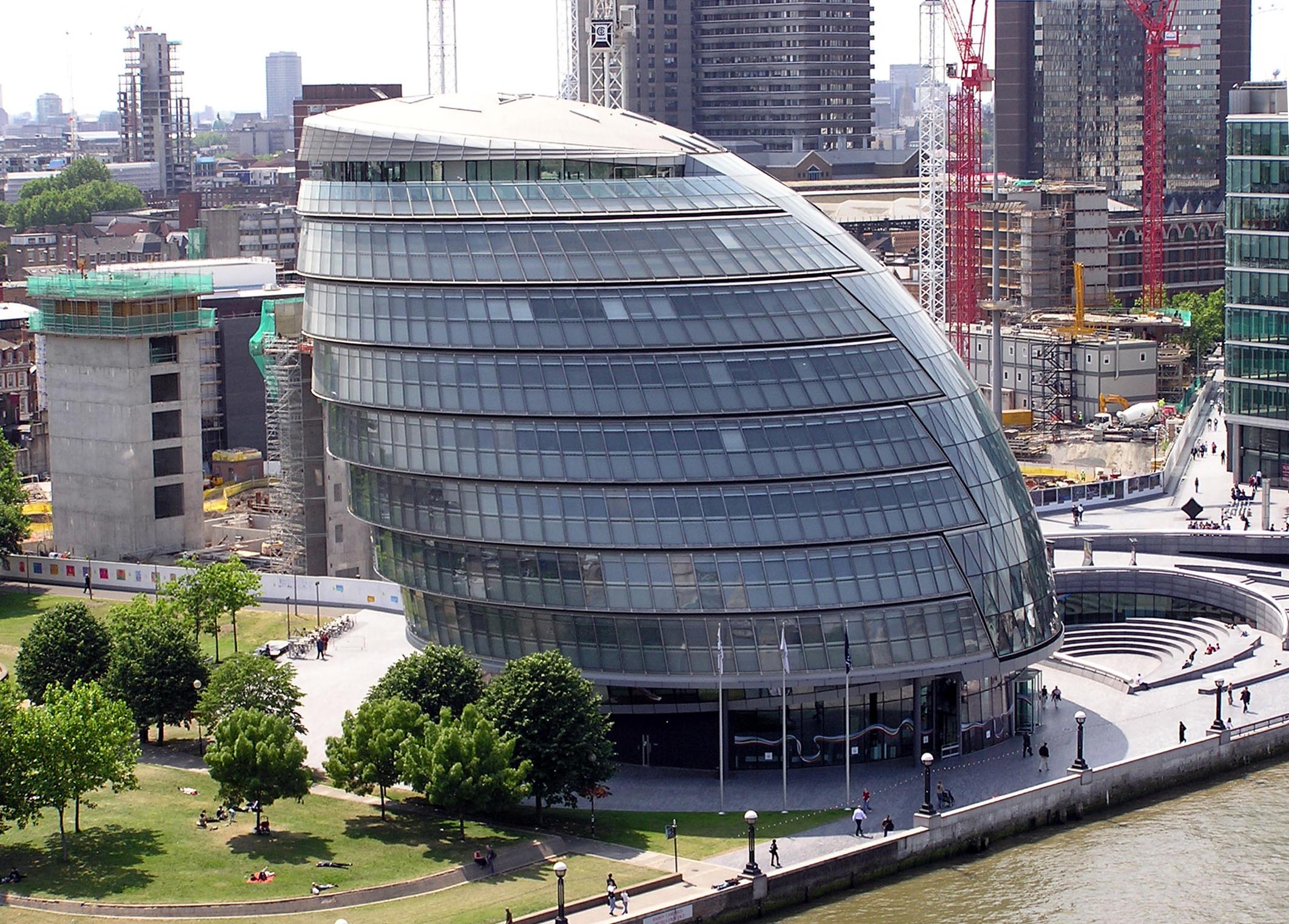
City Hall, taken from the high walkway on Tower Bridge
The northern-end of the borough opposite the City has proven attractive to major professional service firms. Most of these base themselves in the More London and London Bridge City developments. Notable businesses in the area include PriceWaterhouse Coopers, Norton Rose, Ernst & Young and Lawrence Graham.
The press and publishing industry is also well represented in Southwark; the Financial Times has its head office in Southwark Bridge Road,[5][6] IPC Magazines in Southwark Street, and the Evening Standard and Daily Mail at Surrey Quays. Campus Living Villages UK also has its head office in the borough.[7]
Some of the old industrial and wharfside heritage remains at the now defunct Surrey Commercial Docks now Surrey Quays, including Greenland Dock and Baltic Quay, where major residential schemes were developed in the 1980s and 1990s. Near Tower Bridge old warehouses have been converted to new mixed uses at Butler's Wharf and Hay's Wharf. Similarly, further west, the Oxo Tower now hosts restaurants, shops and housing.
Southwark is the home to the Greater London Authority at City Hall.
Educational establishments[]
London South Bank University (LSBU) at its principal Elephant and Castle site has over 23,000 students and 1,700 staff. The Chancellor is the entrepreneur newscaster Richard Farleigh.
The University of the Arts London has two of its colleges in the borough - at Elephant and Castle is the London College of Communication and on Peckham Road is the Camberwell College of Arts.
The largest university teaching hospital in Europe King's College London is at the Guy's Hospital site, merging the teaching activities of the Guy's, St Thomas' and King's College Hospitals here. St Thomas' was founded in the mid-12th Century in the borough and parts of it remain at St Thomas Street; Guy's was founded opposite this in 1725. The Salvation Army maintains the William Booth Memorial Training College at Denmark Hill.
Housing[]
Southwark has a large variety of housing, including substantial areas of council housing, including very large estates such as the Aylesbury Estate and the Heygate Estate both of which are undergoing major redevelopment. Southwark is the London Borough with the largest amount of social housing that is still under direct council control.[8] It also has an active Tenant management organisation sector, of which Leathermarket JMB is the largest.[9]
Courts and judiciary[]
The old Southwark borough had been the location of many Courts and Prisons of Royal Prerogative, the Marshalsea and King’s Bench, as well as the manorial and borough courts the Surrey County magistrates had both sessions and a prison there. The Inner London Sessions House on Newington Causeway descends from these. The Southwark Coroner's Court in Tennis Street dates back to the charter of 1550. In 1964 Southwark Crown Court was opened at English Grounds near London Bridge for local requirements, giving the borough two Crown Courts. Since 1994 the Crown Court for the west London Boroughs, previously based at Knightsbridge, was rehoused in Southwark as Blackfriars Crown Court. When the decision was taken to separate the judiciary and legislature, in 2007, by transforming the House of Lords Judicial Committee of Law Lords into the Supreme Court of the United Kingdom it was given the Middlesex Guildhall in Parliament Square as its residence. This meant that the crown court for Westminster's judges sitting there were transferred to the Southwark Crown Court, hence the senior judge holds the honorific title of the Recorder of Westminster. Apart from these four crown courts (ILCC Newington, Southwark, Wesminster, Blackfriars) Southwark’s local magistrates sit at two courts in the borough, Tower Bridge and Camberwell Green Magistrates Courts.
Few boroughs can boast a single major Court, Southwark has seven jurisdictions.
Civic affairs[]


Tea Trade Wharf, Shad Thames
Mayor[]
The Mayor of Southwark for 2009-2010 was Cllr Tayo Situ (Peckham Ward), who was elected on 19 May 2010. He replaced Cllr Jeff Hook who served from 2009-2010. Cllr Tayo Situ died in office on 9 May 2011, after a brave fight against cancer. Under the civic and legal protocol he was given a full civic and ceremonial funeral and no replacement could be elected until then which delayed the Annual Council Assembly.
The Deputy Mayor, Cllr Lorraine Lauder MBE (Faraday Ward), was elected Mayor of Southwark at the Annual Meeting of Council Assembly on 24 May 2011. The present Mayor is Cllr Abdul Mohamed.
Cabinet[]
The council is run by a Leader and Cabinet Cabinet, chaired by council leader Cllr Peter John. Following the election in 2010 the Cabinet is Labour, replacing the previous Liberal Democrat and Conservative Party coalition.
Coat of arms[]
The two supporters on the coat of arms are an Elizabethan player dressed to play Hamlet to the left, indicating the theatrical heritage of the area, and the youth on the right side is the Esquire from Chaucer's Canterbury Tales. The coat of arms is an amalgam of elements of the three constituent Metropolitan Boroughs arms. The chequered band represents the three boroughs together. The cross was a common feature of Southwark and Camberwell. The well in the centre of the shield is a 'canting' reference to Camberwell and the cinquefoils represent the Dulwich area of Camberwell, while the ship on the top left refers to the maritime history of Bermondsey and was part of the Rotherhithe insignia. The rose on the right is from the Southwark arms where it represented St Saviour's parish, i.e. the Cathedral.
Twinning[]
Southwark is twinned with Langenhagen in Germany, Clichy in France, and Cambridge in the United States.[10][11]
Politics[]
Southwark London Borough Council[]
A Labour council was elected in May 2010. Previously, a Liberal Democrat/Conservative coalition had run Southwark Council since 2002.
Summary of council election results:
| Overall control | Labour | Lib Dem | Conservative | Others | |
| 2010 | Labour | 35 | 25 | 3 | 0 |
| 2006 | Lib Dem/Cons Coalition | 28 ** | 28 ** | 6 | 1 (Green) |
| 2002 | Lib Dem/No overall control | 28 | 30 | 5 | - |
| 1998 | Labour/No overall control | 33(31)* | 27 | 4 | 0(2)* |
| 1994 | Labour | - | - | - | - |
| 1990 | Labour | - | - | - | - |
| 1986 | Labour | - | - | - | - |
| 1982 | Labour | - | - | - | - |
| 1978 | Labour | - | - | - | - |
| 1974 | Labour | - | - | - | - |
| 1971 | Labour | - | - | - | - |
| 1968 | Labour | - | - | - | - |
| 1964 | Labour | - | - | - | - |
(*) Labour won 33 seats in 1998, but 2 members subsequently resigned the whip, leaving no overall control.
(**) Cllr Danny McCarthy (Cathedrals ward) defected from the Libdems to the Labour Party after the 2006 election. Cllr Ola Oyewunmi (Peckham ward) resigned the Labour whip in December 2009, and was admitted to the Liberal Democrat group in January 2010. Cllr Ade Lasaki (South Bermondsey ward) resigned the Lib Dem whip and was admitted to the Labour group in March 2010. Cllr Susan Elan Jones resigned as councillor for the Lane ward to stand for a parliamentary seat in Wales. Her resignation was after the date at which a by-election can be held, leaving the seat vacant until the local elections in May 2010.
Labour were elected to run the council on 6 May 2010, following 4 years of a formal Liberal Democrat/ Tory coalition (the Conservatives held 2/10 executive positions, including deputy leader).
Westminster parliament[]
The borough is covered by three parliamentary constituencies:
- Camberwell and Peckham
- Dulwich and West Norwood (shared with London Borough of Lambeth)
- Bermondsey and Old Southwark
Sport & leisure[]
The London Borough of Southwark has the following sport clubs:
- Non-League football club Dulwich Hamlet F.C. who play at Champion Hill.
- Non-League football club Fisher F.C. who play at Champion Hill.
- Non-League football club Wanderers F.C. who play at Champion Hill.
Transport[]
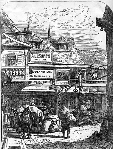

The Tabard Inn, around 1850


Borough Market, circa 1860
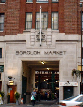

Borough Market, Southwark Street entrance
Bridges and tunnels[]
- Blackfriars Bridge
- London Bridge
- London Millennium Bridge
- Southwark Bridge
- Tower Bridge
- Rotherhithe Tunnel
- Thames Tunnel now part of the Overground
"A" Roads[]
- Roads leading to bridges across the Thames meet at St. George's Circus
- The A201 Inner Ring Road crosses the north-west of the area from the Elephant and Castle to Tower Bridge and the City.
- The A2 runs along Old Kent Road through the north of the borough and is London's main artery from the centre out to Kent.
- The A202 runs along Peckham High Street and passes the town hall.
- The A205 London's South Circular Road runs east-west along Dulwich Common and Thurlow Park Road in the south.
- The boundary with Bromley at Crystal Palace Parade is part of the A212.
London Underground (Tube) stations[]
- Bermondsey
- Borough
- Canada Water
- Elephant & Castle
- Kennington
- London Bridge
- Southwark
London Overground stations[]
- Surrey Quays
- Rotherhithe
- Canada Water
- Denmark Hill
- Peckham Rye
- Queens Road Peckham
Railway stations[]
- Gipsy Hill
- Denmark Hill (also part of London Overground)
- East Dulwich
- West Dulwich
- Elephant & Castle
- London Bridge
- North Dulwich
- Nunhead
- Peckham Rye (also part of London Overground)
- Queens Road Peckham (also part of London Overground)
- Sydenham Hill
- South Bermondsey
Riverbus piers[]
Operated by Thames Clipper
- Bankside Pier - for Tate Modern and the Globe Theatre
- London Bridge City Pier
- Hilton Docklands Nelson Dock Pier
- Greenland Pier
Parking and DVLA database ban[]
In 2012 it was revealed that the Southwark borough council has been permanently banned from accessing information from the Driver and Vehicle Licensing Agency. This information is normally made available to local authorities for purposes such as enforcing parking fines, but access can be withdrawn if they are found to be mis-using the service. The Big Brother Watch organisation, which obtained the information about the ban under a Freedom of Information request, claimed that "the public are right to be worried that their privacy is at risk across a range of government services."[12]
Travel to work[]
In March 2011, the main forms of transport that residents used to travel to work were: bus, minibus or coach, 17.5% of all residents aged 16-74; underground, metro, light rail, tram, 8.5%; train, 8.5%; on foot, 8.2%; driving a car or van, 8.1%; bicycle, 4.9%; work mainly at or from home, 2.8%.[13]
Places[]
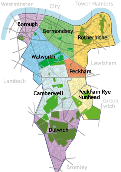

Areas of Southwark
Localities[]
Parks and open spaces[]
- Southwark Park
- Burgess Park, (including trees at New Church Road)
- Dulwich Park
- Belair
- Long Meadow a.k.a. Belle Meadow
- Peckham Rye Park
- Russia Dock Woodland
- Sydenham Hill Wood
- Geraldine Mary Harmsworth Park, Lambeth Road, SE1. This park houses the Imperial War Museum although the Museum only owns the land directly in front of it, and the remainder is a public park.
- Nunhead Cemetery
Notable residents (past and present)[]


London Borough of Southwark Blue Plaque awarded to famous motorcycle designer Edward Turner unveiled in 2009 at his former residence, 8 Philip Walk, Peckham, London SE15
In 2003, the London Borough of Southwark started a blue plaque scheme for the commemoration of notable residents notably including living people in the awards.[14] The London Borough of Southwark awards Blue Plaques through popular vote following public nomination. Unlike the English Heritage scheme, the original building is not necessary for nomination.
References[]
- ^ Data Management and Analysis Group, Greater London Authority, Demography Update October 2007, (2007)
- ^ "Southwark", in The Columbia Lippincott Gazetteer of the World (1952), New York: Colubia University Press.
- ^ Religion in Southwark : London. theLondonArea. Retrieved on 2013-07-17.
- ^ 2011 Census. Statistics.gov.uk (2011-03-27). Retrieved on 2013-07-17.
- ^ "London, United Kingdom." Financial Times. Retrieved on 28 October 2009.
- ^ "Map." London Borough of Southwark. Retrieved on 28 October 2009.
- ^ "Contact." Campus Living Villages. Retrieved on 5 October 2011. "Campus Living Villages UK Woolyard, 56 Bermondsey Street, London SE1 3UD, United Kingdom"
- ^ "Members list". Association of Retained Council Housing. http://www.arch-housing.org.uk/list.html. Retrieved 20 March 2011.
- ^ "Leathermarket JMB". Leathermarket JMB. http://www.leathermarketjmb.org.uk. Retrieved 20 March 2011.
- ^ "A Message from the Peace Commission: Information on Cambridge's Sister Cities," February 15, 2008. Retrieved 2008-10-12.
- ^ Richard Thompson. "Looking to strengthen family ties with 'sister cities'," Boston Globe, October 12, 2008. Retrieved 2008-10-12.
- ^ DVLA bans councils from database over abuses, BBC News, 8 December 2012, http://www.bbc.co.uk/news/uk-politics-20642429, retrieved 10 December 2012
- ^ "2011 Census: QS701EW Method of travel to work, local authorities in England and Wales". Office for National Statistics. http://www.ons.gov.uk/ons/rel/census/2011-census/key-statistics-and-quick-statistics-for-wards-and-output-areas-in-england-and-wales/rft-qs701ew.xls. Retrieved 23 November 2013. Percentages are of all residents aged 16-74 including those not in employment. Respondents could only pick one mode, specified as the journey’s longest part by distance.
- ^ "Blue Plaque Winners 2007". Southwark Borough Council. http://www.southwark.gov.uk/DiscoverSouthwark/BluePlaquesSection/blueplaques2007/.
External links[]
| ||||||||||||||||||||||||||||

| |||||||||||||||||
| This page uses content from the English language Wikipedia. The original content was at London Borough of Southwark. The list of authors can be seen in the page history. As with this Familypedia wiki, the content of Wikipedia is available under the Creative Commons License. |