| Main | Births etc |
|---|
| Hackney | |||
|---|---|---|---|
| — London borough — | |||
|
|||
 |
|||
| Sovereign state | United Kingdom | ||
| Constituent country | England | ||
| Region | London | ||
| Ceremonial county | Greater London | ||
| Status | London borough | ||
| Admin HQ | Mare Street, Hackney | ||
| Incorporated | 1 April 1965 | ||
| Government | |||
| • Type | London borough council | ||
| • Body | Hackney London Borough Council | ||
| • Leadership | Mayor & Cabinet (Labour) | ||
| • Mayor | Jules Pipe CBE | ||
| • MPs | Diane Abbott Meg Hillier |
||
| • London Assembly | Jennette Arnold AM for North East | ||
| • EU Parliament | London | ||
| Area | |||
| • Total | 7.36 sq mi (19.06 km2) | ||
| Area rank | 321st (of 326) | ||
| Population (2006 est.) | |||
| • Total | 247,200 | ||
| • Rank | 61st (of 326) | ||
| • Ethnicity[1] | 47.1% White British 2.6% White Irish 11.2% Other White 1.6% White & Black Caribbean 0.8% White & Black African 0.8% White & Asian 1.2% Other Mixed 4.1% Indian 1.4% Pakistani 2.8% Bangladeshi 1.0% Other Asian 9.2% Black Caribbean 10.8% Black African 2.2% Other Black 1.4% Chinese 1.9% Other |
||
| Time zone | GMT (UTC0) | ||
| • Summer (DST) | BST (UTC+1) | ||
| Postcodes | E, EC, N | ||
| Police force | Metropolitan Police | ||
| Website | hackney.gov.uk | ||
The London Borough of Hackney /ˈhækni/ is a London borough in north east London.[2]
Hackney is bounded by Islington to the west, Haringey to the north, Waltham Forest to the north-east, Newham to the east, Tower Hamlets to the south-east and the City of London to the south-west. Much of Hackney maintains its inner-city character and in places like Dalston large housing estates now sit side-by-side with gated communities. In South Hackney, near Victoria Park, there is terraced Victorian and Edwardian housing.
The historical and administrative heart of Hackney is the area roughly extending north from Mare Street and surrounding the Church of St John-at-Hackney; known as Hackney Central. To the north of the borough are Upper Clapton and Lower Clapton, Stamford Hill and Stoke Newington. To the east is the large open space of Hackney Marshes and the districts of Hackney Wick and Homerton. Light industries in the area around the River Lea employ over 3,000 people and some were also used for the 2012 Summer Olympics.
There are 1,300 listed buildings in Hackney, including the iconic Grade II* Hackney Empire, Tudor Sutton House, and the Grade I medieval St Augustine's Tower. The Borough contains 25 conservation areas including Clapton Square, and urban open-spaces including Clapton Common and Clissold Park. Conservation areas also protect large areas of Georgian and Victorian housing, and areas of industrial heritage.[3]
History[]

St Augustine's Tower. A former property of the Knights of St John dating from the 13th century, St Augustine's Tower is Hackney's oldest building. The tower is all that remains of the medieval parish church, which was demolished in 1798 (September 2005)
The borough was formed in 1965 from the area of the earlier metropolitan boroughs of Hackney, Shoreditch and Stoke Newington. The new council included representative symbols of the predecessor boroughs in its new combined coat of arms: Shoreditch by three bells from Shoreditch Church; Stoke Newington by two trees bearing fruit; and Hackney by the Maltese Cross of the principal landowners of the parish in the Middle Ages. The shield is surmounted by a representation of St. Augustine's Tower.
The council displays, in Hackney Town Hall, a portrait of the Queen wearing the robes of the Most Venerable Order of St John of Jerusalem, of which she is Patron.
The borough has a rich history; the Roman road, Ermine Street, forms the western edge of the borough. Most of the rest of the land was covered with open oak and hazel woodlands, with marshland around the rivers and streams that crossed the area. Hackney lay within the Catuvellauni tribal territory.[4] The eastern boundary of the borough is marked by the River Lea. This was an ancient boundary between pre-Roman tribes, and in the Roman era, was tidal up to Hackney Wick and continued to be the boundary between the historic counties of Middlesex and Essex.

Sutton House was built in 1535
In the Tudor period the lands of religious orders were seized by the Crown and put up for sale. Thus Hackney became a retreat for the nobility around Hackney Central and Homerton, including Henry VIII's Palace by Lea Bridge roundabout, where BSix Sixth Form College stands today.[5] Sutton House, on Homerton High Street, is the oldest surviving dwelling in Hackney, originally built as Bryck Place for Sir Ralph Sadleir, a diplomat, in 1535. The village of Hackney flourished from the Tudor to late Georgian periods as a rural retreat. The first documented "hackney coach"—the forerunner of the more generic "hackney carriage"—operated in London in 1621. Current opinion is that the name "hackney," to refer to a London taxi, is derived from the village name.[6] (Hackney, through its historical fame for its horses and horse-drawn carriages, is also the root of the Spanish word jaca, a term used for a small breed of horse,[7] and the Sardinian achetta horse.) Hackney's rural reputation brought to an end by the construction of the railway in the 1850s.


Curtain Theatre circa 1600 print. Note: some authorities believe this to be a depiction of The Theatre – the other Elizabethan theatre in Shoreditch.
London's first Tudor theatres were built at Shoreditch and the Gunpowder Plot was first exposed nearby in Hoxton too.[8]
Notable residents from the 17th, 18th, and 19th Centuries included Robert Aske, William Cecil, Samuel Courtauld, Samuel Hoare, Joseph Priestley and Thomas Sutton.
Many grand houses stood in Stoke Newington and Stamford Hill, with the latter providing a haven for Hackney's many Orthodox Jewish residents from the 1930s. Alfred Hitchcock made many of his first films in Hoxton at the Gainsborough Studios in Poole Street.[9]
After industrialisation, extensive post-war development and immigration, the area's many Georgian and Victorian terraces are being gentrified, warehouses are being converted and new apartments are being built.[10] It was inner London's 'greenest borough' and London Transport's 'best bike borough 2006',[11] with 62 parks and open spaces, covering 815 acres (3.3 km2).[12] Seven Hackney parks have now achieved Green Flag status.[13] One, Abney Park, became scheduled in 2009 as one of Britain's historic park and garden at risk from neglect and decay.[14] Hackney Marshes play host to the largest collection of football pitches in Europe; and was the site of part of the 2012 Summer Olympics.
Governance[]
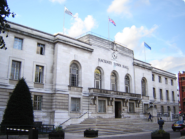

Hackney Town Hall was built in the 1930s for the former Metropolitan Borough. (October 2005)
The borough comprises two parliamentary constituencies: Hackney North and Stoke Newington (represented by Diane Abbott MP) and Hackney South and Shoreditch (represented by Meg Hillier MP); both are Privy Counsellors and Labour Party Members of Parliament. The borough is in the North East London Assembly constituency returning Jennette Arnold AM, as the directly elected Assembly Member. Hackney is part of the London constituency in the European Parliament.
Unlike most other English local authorities, the Borough is now governed by a directly-elected Mayor who is also the political leader of the Council. The Mayor – currently Jules Pipe CBE[15] – is supported by a cabinet, councillors and a Speaker who fulfils the civic and ceremonial duties previously undertaken by the (non-political) mayor.[16]
At the Hackney Council election on 6 May 2010 the Labour Party were returned with 50 Councillors; winning six additional seats. The Conservative Party forms the largest opposition party on the Council with four Councillors; and the Liberal Democrats have three.[17]
City's councils get top ratings (BBC News)[18] Every ward remains among the 10% most deprived in the country, with 47% of children living in low income households.[19]
Hackney has a reputation as one of the most crime-ridden London boroughs, and some of its streets have even been referred to as "Murder Mile",[20] but cooperation between local police and council has resulted in the borough experiencing a bigger drop in crime than in any other London borough in the four-year period up to 2007 (28% reduction).[21]
Geography[]
Location[]
The London Borough of Hackney is an Inner London Borough within Greater London. It is to the north-east of the City of London; and neighboured by the London Boroughs of Tower Hamlets, to the south; Islington to the west at Southgate Road; Haringey to the north. On the east, the River Lea forms the boundary with Waltham Forest; and to the south-east is Newham. Historically, the River Lea formed the boundary between the predecessor counties of Middlesex and Essex.
Hackney Town Hall is approximately 5 miles (8 km) north-east of Charing Cross, St Pauls Cathedral being situated in between; and 3.8 miles (6.1 km) from the GLA City Hall near Tower Bridge.
Districts and postcodes[]
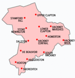
Some locations in the London Borough of Hackney.
The most southerly district in the borough is Shoreditch, adjacent to the City. To the north-west, bordering Islington, the City, and north of Old Street is Hoxton. To the north of Shoreditch is Haggerston, north of the Regents Canal. Bethnal Green also forms of the southern parts of the borough, also this is formally and majoritised within neighbouring Tower Hamlets.
Settlements to the west of the borough followed the line of the former Ermine Street, with De Beauvoir Town — a Victorian estate to the west of the (now) Kingsland Road. Further north, lie Dalston, Stoke Newington and Stamford Hill — where the borough abuts Haringey.
A further group of settlements follow another north-south radial road, with South Hackney to the east of Cambridge Heath Road — north of Victoria Park; and Hackney Central commencing at Mare Street. London Fields was formerly common land to the west of this place, but now forms a district in its own right. To the north, Homerton lies immediately east of the centre of Hackney. The River Lea forms the borough's eastern boundary. Hackney Wick, the Hackney Marshes, Lower and Upper Clapton all lie along this eastern boundary.
Postal districts were assigned to the former parts of the borough in 1857/8. Most of the borough would originally have been covered by a planned 'NE' postal district, but this was abolished in 1866. Most of the borough is covered by the eastern postal district, but Shoreditch constitutes five separate postcodes. Areas to the west of Kingsland Road and in the north of the borough are predominantly covered by the northern postal district.
Traditionally, much of the borough was and remains considered as a part of East London, with Hoxton and Shoreditch being part of the East End of London. In the 2008 revision of the London Plan, the borough was officially reassigned to the north London sub-region for administrative purposes.[2]
Topography[]
The London Borough of Hackney covers an area of 19.06 square kilometres (7.4 sq mi). Its primary geographic feature is the course of the River Lea; and the associated River Lee Navigation, which passes through Hackney Cut — an artificial channel of the Lea built in 1770 across the Hackney Marshes to straighten a meander of the natural river. A tributary of the Lea, Hackney Brook was fully culverted in 1860 by the Metropolitan Board of Works.[22]
The New River passes through the borough close to Finsbury Park and flows towards Islington. The Regents Canal also crosses the borough to the south of De Beauvoir Town in the west, joining the Hertford Union Canal below Victoria Park.[22]
Within the Borough, the land rises westward from the Lea reaching 30 metres (98 ft) above sea level at Clapton Common and Stamford Hill. The area around Victoria Park, in the south of the borough lies about 15 metres (49 ft) above sea level. At Spring Hill, in Upper Clapton the road descends sharply from 25 metres (82 ft) to only 10 metres (33 ft) at High Hill Ferry, on the Lee Navigation.[22]
Geology[]
The Lea and Hackney Marshes are underlain by alluvium soils; and the higher ground between Homerton and Stamford Hill is formed on a widening bed of London Clay. Brickearth deposits are within tongues of clay extending beneath Clapton Common, Stamford Hill and Stoke Newington High Street. The centre and south western districts lie on river terrace deposits of Taplow Gravel. Victoria Park and Well Street Common lie on flood plain gravel.[22]
Climate[]
This data was taken between 1971 and 2000 at the nearest national weather station in Greenwich; around 7 miles (11.3 km) south of Hackney Town Hall: Template:ClimateGreenwich
Demography[]
| Population | ||
|---|---|---|
| Year | Pop. | ±% |
| 1801 | 14,609 | — |
| 1811 | 19,523 | +33.6% |
| 1821 | 25,342 | +29.8% |
| 1831 | 35,482 | +40.0% |
| 1841 | 68,246 | +92.3% |
| 1851 | 94,961 | +39.1% |
| 1861 | 172,385 | +81.5% |
| 1871 | 249,810 | +44.9% |
| 1881 | 327,234 | +31.0% |
| 1891 | 369,209 | +12.8% |
| 1901 | 374,132 | +1.3% |
| 1911 | 379,120 | +1.3% |
| 1921 | 368,469 | −2.8% |
| 1931 | 358,117 | −2.8% |
| 1941 | 305,501 | −14.7% |
| 1951 | 260,626 | −14.7% |
| 1961 | 240,521 | −7.7% |
| 1971 | 221,975 | −7.7% |
| 1981 | 179,536 | −19.1% |
| 1991 | 187,792 | +4.6% |
| 2001 | 202,819 | +8.0% |
| 2010 | 213,573 | +5.3% |
| Source: A Vision of Britain through time | ||
In 1801, the civil parishes that form the modern borough had a total population of 14,609. This rose steadily throughout the 19th century, as the district became built up; reaching 95,000 in the middle of that century. When the railways arrived the rate of population growth increased — reaching nearly 374,000 by the turn of the century. This increase in population peaked before World War I, falling slowly in the aftermath until World War II began an exodus from London towards the new towns under the Abercrombie Plan for London (1944).[23] The population is now rising again, and the 2001 census gives Hackney a population of 202,824.[24]
The population is ethnically diverse. Of the resident population, 89,490 (41%) people describe themselves as White British. 30,978 (14%) are in other White ethnic groups, 63,009 (29%) are Black or Black British, 20,000 (9%) are Asian or Asian British, 8,501 (4%) describe themselves as 'Mixed', and 6,432 (3%) as Chinese or Other.


Stamford Hill has a large Haredim (Hasidic) population.
There is also a large Turkish and Kurdish population resident in Hackney. Turkish and Kurdish communities are located in all parts of the borough, though there is a greater concentration in north and central Hackney.
132,931 (66%) of the resident population were British born. A further 10,095 (5%) were born in other parts of Europe, and the remaining 59,798 (29%) born elsewhere in the world.
The 2001 census also shows Christianity is the biggest religion in Hackney, with 44% of residents identifying Christian; 18% identified as Muslim, 4% Jewish, and 3% belonged to other religions. A further 19% stated no religion, and 12% did not state a response. By the 2011 census, residents identifying themselves as Christian fell to 38.6%, whilst those with no religion rose to 28.2%. Judaism had a modest increase, Islam had a small increase, and Hinduism made a slight drop.
32% of households are owner–occupied.
The largest rise of ethnic groups between 2001 and 2011 was 'Other', which increased by 222%. This was followed by 'Mixed', which rose by 84%.
As of the 2011 census, 6.3% of the population is Jewish, making it the third biggest in England after London Borough of Barnet and the Hertsmere borough of Hertfordshire.
Education[]
In 2002, the borough entered into a ten-year contract with the Learning Trust, an independent collaborative body that organises education for Hackney's 27,000 pupils in over 70 schools, nurseries and play centres. The trust was set up in response to an OFSTED report that identified failings in the then existing system.[25] Two of London's most successful City Academies are in Hackney with another two in development and plans to rebuild or renovate every other Hackney school by 2016.
Transport[]
Hackney is hardly served by London Underground services: Only Manor House, located on its extreme north-western fringe on the boundary with Haringey, though Old Street sits only a few metres south-west of Hackney in Islington.
However, two London Overground lines serve Hackney: the North London Line crosses from west to east while the East London Line runs from Highbury & Islington and passes through Dalston Junction and on south through Haggerston, Hoxton, Shoreditch towards destinations south of the River Thames, including Clapham Junction, Crystal Palace, Croydon, and New Cross.
Additionally National Rail's Lea Valley Lines also pass through Hackney, with stations at London Fields, Hackney Downs, Rectory Road, Stoke Newington, Stamford Hill, and Clapton.
It is proposed that Crossrail 2, the 'Chelsea-Hackney Line', would provide a direct Underground service to Hackney Central, Dalston and Homerton, although it is currently undecided whether this would be built as London Underground or main line specifications.


A busy sunset over Graham Road (with some contrails), Hackney Central (19 September 2005—3 days before the autumnal equinox)
London Overground[]
North London Line Travelling west to east — nearest London Overground stations are Dalston Kingsland, Hackney Central, Homerton and Hackney Wick
East London Line Travelling north to south — nearest London Overground stations are Dalston Junction, Haggerston, Hoxton and Shoreditch High Street
Lea Valley Lines[]
These stations are served by Abellio Greater Anglia:
- Stamford Hill railway station
- Stoke Newington railway station
- Rectory Road railway station
- Clapton railway station
- Hackney Downs railway station
- London Fields railway station
Travel to work[]
In March 2011, the main forms of transport that residents used to travel to work were: bus, minibus or coach, 16.9% of all residents aged 16–74; underground, metro, light rail, tram, 9.2%; bicycle, 9.2%; on foot, 7.5%; driving a car or van, 7.1%; train, 4.6%; work mainly at or from home, 3.5%.[26]
Notable associated people[]
Notable attractions and institutions[]


Flats built in the site of Gainsborough Studios in Hoxton
- Abney Park Cemetery – overgrown Victorian cemetery and Nature Reserve
- Arcola Theatre – studio theatre
- National Centre of Circus Arts – circus school
- Geffrye Museum – decorative arts museum
- Hackney Empire – theatre
- Hoxton Hall – community centre and performance space
- Newington Green Unitarian Church – London's oldest nonconformist place of worship
- St John's Hoxton – Anglican church (where "Amazing Grace" was written)
- Shoreditch Town Hall
- Sutton House – Heritage house and museum
- The Towers of Hackney
- Transition Gallery – contemporary art project space
- Victoria Miro Gallery – contemporary art gallery
- Vortex Jazz Club – live jazz venue
- White Cube – contemporary commercial art gallery
Twinned towns[]
The London Borough of Hackney has formal twinning arrangements with:
| Flag | Country | Town[27] | Region |
|---|---|---|---|
| Barbados | Bridgetown | Caribbean | |
| France | Suresnes[28] | Western Paris | |
| Germany | Göttingen | Lower Saxony | |
| Grenada | St George's | Caribbean | |
| Israel | Haifa | Northern Israel | |
| Russia | Presnensky District | Moscow suburb | |
| USA | Austin[29] | Travis County |
And an informal twinning with
 Alexandra, South Africa.[27]
The borough also has informal links with South Africa, Turkey, and Saint Vincent and the Grenadines. The Homerton University Hospital has its own twinning arrangements with the Rambam Medical Centre (Haifa, Israel) and St George's Hospital (Grenada). Schools are encouraged to pursue links with specific schools abroad – such as the arrangement between Our Lady's and a school in Hangzhou, South West China.[27]
References[]
- ^ Data Management and Analysis Group, Greater London Authority, Demography Update October 2007, (2007)
- ^ a b Map 5A.1 – London's sub-regions The London Plan (Greater London Authority, 2008) accessed 13 November 2009
- ^ Hackney Society photographic survey accessed 23 January 2007
- ^ Roman Landscape (Brickfields Building Exploratory) accessed 10 May 2007
- ^ 'Hackney: Settlement and Building to c.1800', A History of the County of Middlesex: Volume 10: Hackney (1995), pp. 10–4 Date accessed: 2 October 2006
- ^ "The history of the word "Hackney"". Worldwidewords.org. 2002-05-11. http://www.worldwidewords.org/qa/qa-hac1.htm. Retrieved 2011-11-20.
- ^ "DICCIONARIO DE LA LENGUA ESPAÑOLA". REAL ACADEMIA ESPAÑOLA. http://buscon.rae.es/draeI/SrvltConsulta?TIPO_BUS=3&LEMA=jaca. Retrieved 7 April 2011.
- ^ Houses of Parliament factsheet on event accessed 6 March 2007
- ^ Visiting Hackney accessed 10 May 2007
- ^ Location, Location: Best and Worse Hackney One Year On (Channek 4 TV) accessed 7 November 2007
- ^ Hackney wins best bike borough (LBH Press release, 6 April 2006) accessed 7 November 2007
- ^ Parks department (LB Hackney) accessed 7 November 2007
- ^ Hackney Today 188 21 July 2008
- ^ English Heritage's 'At Risk' register accessed 5 July 2010
- ^ Results for the Mayoral Election on 6 May 2010 accessed 26 May 2010
- ^ The Speaker of Hackney Council accessed 27 May 2010
- ^ Mayor and Council Elections 2010 accessed 26 May 2010
- ^ [1] 7 February 2008, accessed 8 February 2008
- ^ Corporate Assessment Report: London Borough of Hackney (The Audit Commission August 2006) accessed 4 December 2007
- ^ Two more die on 'murder mile' | UK News | The Observer
- ^ Hackney Today 157 23 April 2007 accessed 6 June 2007
- ^ a b c d Hackney: Introduction, A History of the County of Middlesex: Volume 10: Hackney (1995), pp. 1–4. Date accessed: 13 June 2009
- ^ A Vision of Britain through time accessed 20 February 2009
- ^ Statistics for ethnicity [2], country of birth [3], and religion [4] are from the UK census.
- ^ Learning Trust history accessed 5 May 2007
- ^ "2011 Census: QS701EW Method of travel to work, local authorities in England and Wales". Office for National Statistics. http://www.ons.gov.uk/ons/rel/census/2011-census/key-statistics-and-quick-statistics-for-wards-and-output-areas-in-england-and-wales/rft-qs701ew.xls. Retrieved 23 November 2013. Percentages are of all residents aged 16-74 including those not in employment. Respondents could only pick one mode, specified as the journey’s longest part by distance.
- ^ a b c Twinning (LB Hackney) Accessed 19 September 2008
- ^ "British towns twinned with French towns [via WaybackMachine.com"]. Archant Community Media Ltd. Archived from the original on 5 July 2013. http://web.archive.org/web/20130705094933/http://www.completefrance.com/language-culture/twin-towns. Retrieved 2013-07-20.
- ^ Barnett, Marissa (2014-02-27). "Austin picks up 13th sister city in London borough of Hackney". Austin American-Statesman (Cox Media Group). http://www.statesman.com/news/news/local/austin-picks-up-13th-sister-city-in-london-borough/nd27r/. Retrieved 2014-02-28.
External links[]
![]() London/Hackney travel guide from Wikivoyage
London/Hackney travel guide from Wikivoyage
- Official site of Hackney council
- Hackney Conservative Party Links to Conservative Councillors, London Assembly Members and MEPs
- Hackney Labour Party Links to Labour Councillors, London Assembly Members and MEPs
- Hackney Liberal Democrats Links to Liberal Democrat Councillors, London Assembly Members and MEP
- Hackney Green Party Links to Green Councillor, London Assembly Members and MEP
- Hackney Independent Link to Hackney Independent Party
- Hackney Rugby Football Club
- The Hackney Society (Heritage Conservation)
- Hackney Walks
- Tudor Life in Hackney (National Archives)
- Hackney Silver Surfers
- Hackney Museum
- Timeline Educational site presenting Hackney history.
- The Hackney Podcast
- The Hackney Citizen A local newspaper based in Hackney
| |||||||||||||||||||||||||

| |||||||||||||||||
| This page uses content from the English language Wikipedia. The original content was at London Borough of Hackney. The list of authors can be seen in the page history. As with this Familypedia wiki, the content of Wikipedia is available under the Creative Commons License. |