| ||||||||||||||
| Kullu district | |
|---|---|
| — District of Himachal Pradesh — | |
 |
|
| Country | India |
| State | Himachal Pradesh |
| Established | |
| Headquarters | Kullu |
| Tehsils | Kullu, Nirmand, Banjar, Manali |
| Area | |
| • Total | 5,503 km2 (2,125 sq mi) |
| Population (2001) | |
| • Total | 379,865 |
| • Density | 69/km2 (180/sq mi) |
| • Urban | 7.92% |
| Demographics | |
| • Literacy | 63.45% |
| • Sex ratio | 105% |
| Website | Official website |
Kullu is a district in Himachal Pradesh, India. The district stretches from the village of Rampur in the south to the Rohtang Pass in the North.

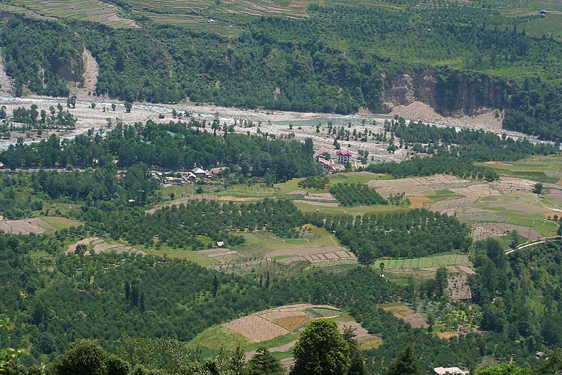
Fields & Beas River in Kullu District of Himachal Pradesh, India.
The largest valley in the district is called the Kullu Valley, which is also known as the Valley of the Gods. There is also a town called Kullu which sits on the banks of the Beas River in the central part of the valley. Another important valley in the district is the Lug valley where the main forest contractors have been extracting timber from the forests for the last 150 years and continue to do so today.[1] Farther north lies the town of Manali.
The ancient seat of the kings of Kullu was at Naggar Castle, about 12 km north of the present town, and thought to have been built in the early 17th century by Raja Sidh Sing. Raja Jagat Singh (1637-72) moved the capital in the middle of the 17th century to its present position, and called it Sultanpur. The Royal compound consists of the "Rupi Palace, several temples, and a long narrow bazaar descending the hill."
The British took all of Kangra and Kullu from the Sikhs in 1846. It is still used as home by the royal descendants, but the more ancient Naggar Castle was sold to the British.
Since the onset of the most recent unrest in Kashmir, Manali and the Kullu Valley in general, have become important destinations for tourists escaping the summer heat of India.
In the eastern part of the district, the village of Manikaran contains Sikh and Hindu temples and popular hot springs. The Hidimba Devi Temple is at Manali. There are also many Sikh villages located close to Manikaran. To the northeast of Kullu Valley, lies the famous, Malana Valley.
Demographics[]
According to the 2011 census Kullu district has a population of 437,474 ,[2] roughly equal to the nation of Malta.[3] This gives it a ranking of 553rd in India (out of a total of 640).[2] The district has a population density of 79 inhabitants per square kilometre (200 /sq mi) .[2] Its population growth rate over the decade 2001-2011 was 14.65 %.[2] Kullu has a sex ratio of 950 females for every 1000 males,[2] and a literacy rate of 80.14 %.[2]
Gallery[]
")
")
")
")
")
")
")
")
")
See also[]
- Lug Valley
- Kullu Valley
- Malana, Himachal Pradesh
See notes[]
- ^ "History of Ropeways in Kullu". http://mountaintechnology.tripod.com/ropeway/history.html. Retrieved 2006-12-24.
- ^ a b c d e f "District Census 2011". Census2011.co.in. 2011. http://www.census2011.co.in/district.php. Retrieved 2011-09-30.
- ^ US Directorate of Intelligence. "Country Comparison:Population". https://www.cia.gov/library/publications/the-world-factbook/rankorder/2119rank.html. Retrieved 2011-10-01. "Malta 408,333 July 2011 est."
Further reading[]
Chetwode, Penelope. 1972. Kulu: The End of the Habitable World. John Murray, London. Reprint: Time Books International, New Delhi. ISBN 81-85113-20-3
External links[]
- DISTRICT PROFILE
- CULTURAL & TOURISM HERITAGE OF THE DISTRICT
- Birds, Butterflies, Landscapes etc. of Kullu District
- Birds of Kullu District
- Butterflies of Kullu District
- Landscapes of Kullu District

|
Kangra district | Lahaul and Spiti district |
| |
| Mandi district | Kinnaur district | |||
 Kullu district | ||||
| Shimla district |
| |||||
| Lakes | Renuka Lake | Maharana Pratap Sagar | Gobind Sagar (more...) |
|---|---|
| Rivers | Beas | Chenab | Ravi | Sutlej | Yamuna |
| Districts | Bilaspur | Chamba | Hamirpur | Kangra | Kinnaur | Kullu | Lahul and Spiti | Mandi | Sirmaur | Shimla | Solan | Una |
| Other | Climate of Himachal Pradesh | Protected areas of Himachal Pradesh | List of peaks in Himachal Pradesh |
| This Himachal Pradesh location article is a stub. You can help by expanding it. |
| This page uses content from the English language Wikipedia. The original content was at Kullu district. The list of authors can be seen in the page history. As with this Familypedia wiki, the content of Wikipedia is available under the Creative Commons License. |