| Kearney, Nebraska | |
|---|---|
| — City — | |
 |
|
 |
|
| Coordinates: Coordinates: | |
| Country | United States |
| State | Nebraska |
| County | Buffalo |
| Government | |
| • Mayor | Stanley Clouse |
| Area | |
| • Total | 13.2 sq mi (34.2 km2) |
| • Land | 12.7 sq mi (31.6 km2) |
| • Water | 0.5 sq mi (1.2 km2) |
| Elevation | 2,152 ft (656 m) |
| Population (2010) | |
| • Total | 30,787 |
| • Density | 2,498.5/sq mi (964.7/km2) |
| Time zone | Central (CST) (UTC-6) |
| • Summer (DST) | CDT (UTC-5) |
| ZIP Codes | 68845, 68847, 68848 (P.O. Box), 68849 UNK |
| Area code(s) | 308 |
| FIPS code | 31-25055[1] |
| GNIS feature ID | 0830442[2] |
| Website | www.cityofkearney.org |
Kearney (![]() /ˈkɑrni/)[3] is a city in and the county seat of Buffalo County, Nebraska, United States.[4] The population was 30,787 at the 2010 census.[5] It is home to the University of Nebraska-Kearney.
/ˈkɑrni/)[3] is a city in and the county seat of Buffalo County, Nebraska, United States.[4] The population was 30,787 at the 2010 census.[5] It is home to the University of Nebraska-Kearney.
Kearney is the principal city of the Kearney, Nebraska Micropolitan Statistical Area, which consists of Buffalo and Kearney counties.
Geography[]
Kearney is located at (40.700731, -99.081150)[6]. Located on the north bank of the Platte River in Central Nebraska, Kearney is 1733 miles from San Francisco and 1733 miles from Boston. [7]Strategically located on I-80 with convenient access to major markets like Omaha-Lincoln, Denver, Kansas City, Des Moines, Wichita and Cheyenne, Kearney is at the center of a 7-state region and 20 million people. [8] According to the United States Census Bureau, the city has a total area of 13.2 square miles (34 km2), of which 12.7 square miles (33 km2) is land and 0.5 square miles (1.3 km2) is water.
Demographics[]
| Historical populations | |||
|---|---|---|---|
| Census | Pop. | %± | |
| 1880 | 1,782 | ||
| 1890 | 8,074 | 353.1% | |
| 1900 | 5,634 | −30.2% | |
| 1910 | 6,202 | 10.1% | |
| 1920 | 7,702 | 24.2% | |
| 1930 | 8,575 | 11.3% | |
| 1940 | 9,643 | 12.5% | |
| 1950 | 12,115 | 25.6% | |
| 1960 | 14,210 | 17.3% | |
| 1970 | 19,181 | 35.0% | |
| 1980 | 21,158 | 10.3% | |
| 1990 | 24,396 | 15.3% | |
| 2000 | 27,431 | 12.4% | |
| 2010 | 30,787 | 12.2% | |
As of the census[1] of 2010, there were 30,787 people, 10,549 households, and 6,160 families residing in the city. The population density was 2,498.5 people per square mile (964.6/km2). There were 11,099 housing units at an average density of 1,010.9 per square mile (390.3/km2). The racial makeup of the city was 95.18% White, 0.63% African American, 0.38% Native American, 0.92% Asian, 0.04% Pacific Islander, 1.68% from other races, and 1.17% from two or more races. Hispanic or Latino of any race were 4.08% of the population.
There were 10,549 households out of which 30.3% had children under the age of 18 living with them, 45.7% were married couples living together, 9.7% had a female householder with no husband present, and 41.6% were non-families. 28.7% of all households were made up of individuals and 9.5% had someone living alone who was 65 years of age or older. The average household size was 2.37 and the average family size was 2.96.
In the city the population was spread out with 22.2% under the age of 18, 23.9% from 18 to 24, 26.2% from 25 to 44, 17.1% from 45 to 64, and 10.6% who were 65 years of age or older. The median age was 27 years. For every 100 females there were 92.6 males. For every 100 females age 18 and over, there were 89.7 males.
The median income for a household in the city was $34,829, and the median income for a family was $46,650. Males had a median income of $30,150 versus $22,366 for females. The per capita income for the city was $17,713. About 7.4% of families and 13.4% of the population were below the poverty line, including 11.8% of those under age 18 and 8.9% of those age 65 or over.
Notable people From Kearney[]
- Alexander H. Conner - politician
- Leslie Easterbrook - American actress
- Peter G. Peterson - Co-Founder of the Blackstone Group
- Kyle Larson- NFL Player
- Tim Schlattmann - American screenwriter
- Kathy Lou Schultz - American poet and Scholar
Attractions[]
One of Kearney's greatest strengths is its rich heritage, which has been preserved in museums, many of which reflect itslocation of being on the Mormon, Oregon, California Trails and the Pony Express. Kearney is home to the Great Platte River Road Archway Monument, which spans Interstate 80 at mile marker 274. The structure is two-stories of fascinating interactive exhibitory that traces the history of the Great Platte River Road from Oregon Trail days to the fiber optic future world of tomorrow. [9] On December 8, 2000, while on a visit to Kearney, President Bill Clinton toured the Great Platte River Road Archway Monument. [10] Jack Nicholson was also filmed in a scene at the Archway for the movie About Schmidt. [11]
Kearney is home to the Museum of Nebraska Art (MONA), the state's official art collection, which houses a 175 years of great art from the 19th century to the contemporary scene. [12] Also the George W. Frank House, a 1890's historic mansion located at the University of Nebraska at Kearney. Located in the town's Central Elementary School is the Robert M. Merryman Performing Arts Center, a 750-seat theatre completed in 2006. [13]
Kearney is home to the 5,500 seat Viaero Event Center, which hosts numerous concerts, events and performances all year round and is home to the Tri-City Storm, a USHL Hockey Team. [14]
Two microbreweries, Thunderhead Brewing and the Platte Valley Brewery, are located in downtown Kearney. [15]
History[]
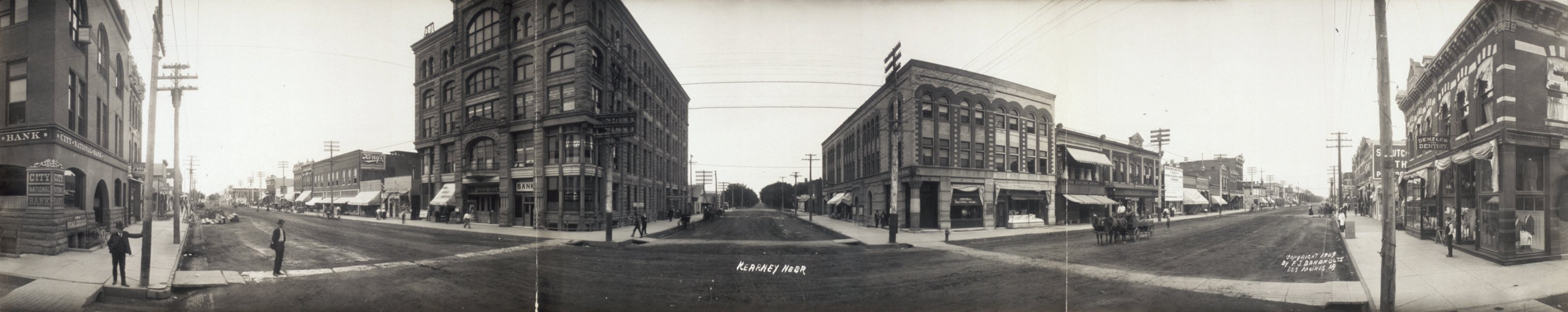
Parade of U.S. Infantry through Kearney, Nebraska, 1888.
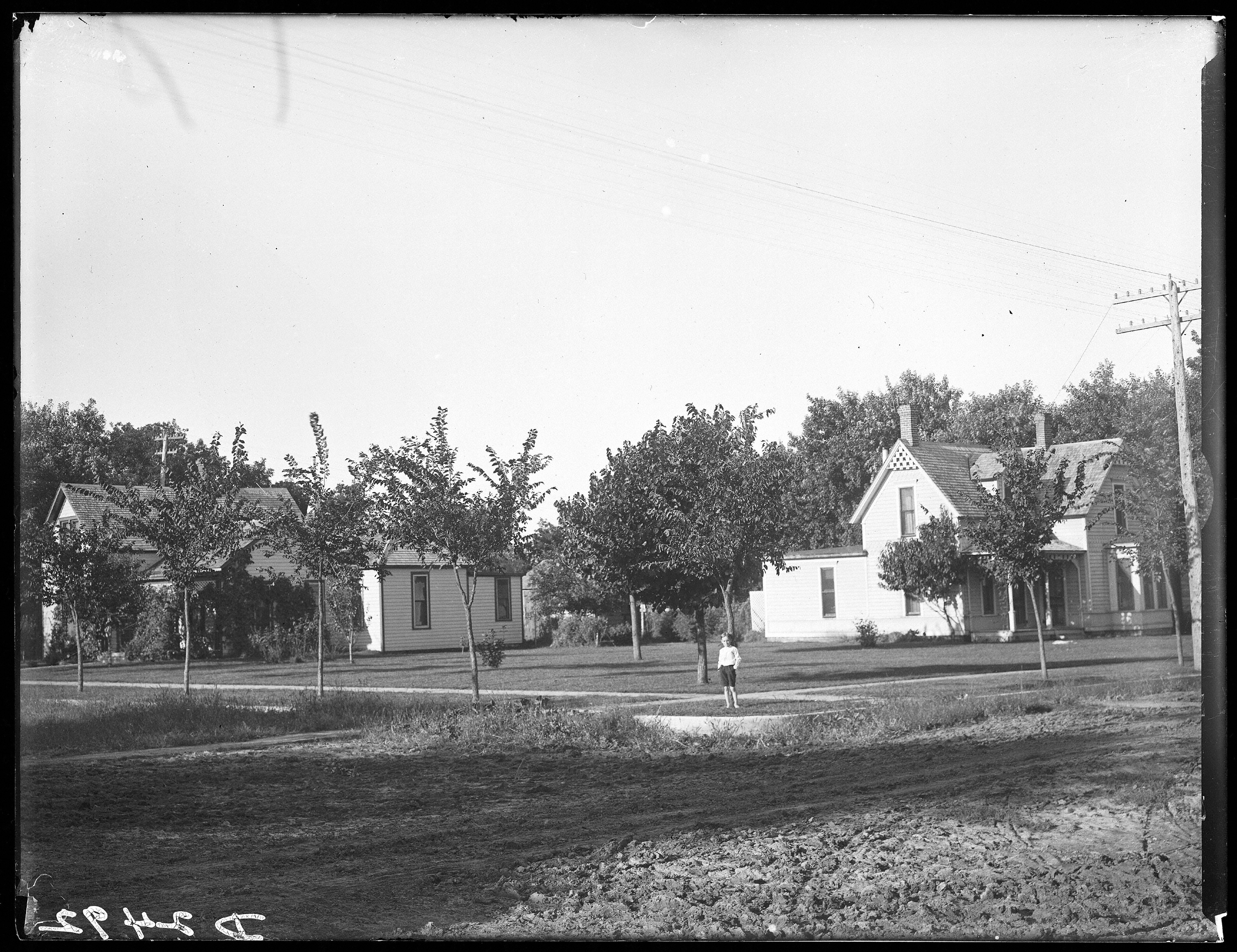

Streets of Kearney, Nebraska showing houses and one person, c. 1907
Before Kearney was named Kearney, it was called Dobytown and it was located 2 miles (3.2 km) southeast of the present-day Kearney. Later the city was moved and renamed after the nearby Fort Kearny (with an extra "e" added, but pronounced the same), a United States Army outpost along the Oregon Trail in the middle 19th century. The fort was named after Col. and later General Stephen W. Kearny. The "e" was added by mistake sometime afterwards by postmen who consistently misspelled the town name. Eventually it just stuck. The current location of the city is on the North side of the Platte River and steadily grew as a result of the influence of the railroad.
Recent growth in the city has been dramatic. The city is expanding quickly to the North, East, and West. The biggest employers in the city are the Good Samaritan Hospital and the University of Nebraska at Kearney. Other major employers include The Buckle Corporate Headquarters, Eaton Corporation, Baldwin Filters, Marshall Engines Inc, and West Company Pharmaceuticals.
Kearney Tornadoes[]
On May 29, 2008 Kearney was hit by 3 tornades. At about 5:30pm tornadoes started to hit Kearney and lasted about 15 minutes. The majority of the damage was to the Northern part of the town. There were also reports of damage on several homes and farms in the rural parts of Buffalo County.
Government[]
The council-manager form is used in Kearney. The City Council makes legislative and policy-making decisions. There are five members elected city-wide to serve four year terms which are staggered. The council manager form of government was adopted in 1950.
The council appoints a City Manager to implement policies, prepare a budget, appoints department heads, and recommends areas that the council needs to attend. There are five members elected city-wide serving staggered four year terms. One member of the City Council is chosen by the council to be Mayor. Stanley Clouse is the Mayor.[16][17]
Gov. Dave Heineman has announced that Kearney is one of two cities that has been selected to participate in a new initiative designed to develop a new technology/data center park in Nebraska.
University[]
University of Nebraska at Kearney (UNK) is located in the city. The campus is a 235-acre (0.951 km2) residential campus with more than 37 buildings. It was founded in 1905 as Nebraska State Normal School at Kearney and became Nebraska State Teachers College in 1921. Between 1963 and 1991 the school was known as Kearney State College. The college's name was changed to University of Nebraska at Kearney in 1991 when it joined the University of Nebraska system.
Outdoor Areas[]
- Apollo Park
- Buffalo Ridge Golf Course
- Centennial Park
- Collins Park
- Cottonmill Lake Recreation Area
- Dryden Park
- Harmon Park
- Harvey Park
- Kearney Country Club
- Meadowlark Hills Golf Course
- Memorial Field
- Pioneer Park
- Nina Hammer Park
- Ted Baldwin Field
- West Lincoln Way
- E.K. & Mary Yanney Heritage Park
- Fort Kearny State Historical Park and Recreation Area
Media[]
- Kearney Hub
- KHGI-TV
Education[]
- Kearney Public Schools operates 3 preschools, 12 elementary schools, 2 middle schools, and Kearney High School[18]
- Zion Lutheran School
- Faith Christian School of Kearney
- Kearney West High School, at the Youth Rehabilitation and Treatment Center[19]
- Kearney Catholic High School
- University of Nebraska at Kearney
- University of Nebraska Medical Center College of Nursing, Kearney Division
References[]
- ^ a b "American FactFinder". United States Census Bureau. http://factfinder.census.gov. Retrieved 2008-01-31.
- ^ "US Board on Geographic Names". United States Geological Survey. 2007-10-25. http://geonames.usgs.gov. Retrieved 2008-01-31.
- ^ "Nebraska Pronunciation Guide". Associated Press. http://www.ap.org/nebraska/pronunciation.htm. Retrieved 2010-01-28.
- ^ "Find a County". National Association of Counties. http://www.naco.org/Counties/Pages/FindACounty.aspx. Retrieved 2011-06-07.
- ^ http://www.kearneyhub.com/news/local/article_ec655b06-4e62-11e0-9533-001cc4c03286.html
- ^ "US Gazetteer files: 2010, 2000, and 1990". United States Census Bureau. 2011-02-12. http://www.census.gov/geo/www/gazetteer/gazette.html. Retrieved 2011-04-23.
- ^ Kearney Visitors Bureau
- ^ Buffalo County Economic Development
- ^ http://www.visitkearney.org/HISTORICAL
- ^ http://abcnews.go.com/Politics/story?id=122382&page=1#.Tx5CNoHuYdQ
- ^ http://www.roadsideamerica.com/story/9790
- ^ http://www.visitkearney.org/Article/MUSEUM-OF-NEBRASKA-ART-lprnMONArprn
- ^ http://blog.kearneypublic.org/merryman/
- ^ http://www.kearneyevents.com/AboutUs/OurFacility/tabid/125/Default.aspx
- ^ http://www.visitkearney.org/BAR-or-NIGHTLIFE
- ^ http://www.cityofkearney.org/documents/Administration/Kearney%20Connection%20December%202008.PDF The Kearney Connection. Retrieved 2009-08-13.
- ^ City of Kearney: Form of Government. Retrieved 2009-08-13.
- ^ "District Snapshot". Kearney Public Schools. Retrieved 2009-11-05.
- ^ "About YRTC—Kearney". Nebraska Department of Health & Human Services. http://www.hhs.state.ne.us/jus/YRTC/AboutYRTCK.htm. Retrieved 2009-11-06.
External links[]
- City of Kearney, Nebraska
- Kearney Hub Local Newspaper
- Kearney Public Library
- Buffalo County Economic Development Council
- Adventure Racing in Kearney
| ||||||||||||||||||||
| ||||||||||||||||||||
| This page uses content from the English language Wikipedia. The original content was at Kearney, Nebraska. The list of authors can be seen in the page history. As with this Familypedia wiki, the content of Wikipedia is available under the Creative Commons License. |