| ||||||||||||||
| Karaikal district காரைக்கால் Karaikal |
|
|---|---|
| — town — | |
| Nickname(s): Karaikal | |

Karaikal district |
|
| Coordinates: Coordinates: | |
| Country | |
| State | Puducherry |
| District | Karaikal |
| Population (2012) | |
| • Total | 170,791 |
| Languages | |
| • Official | Tamil |
| Time zone | IST (UTC+5:30) |
| PIN | 609 601 |
| Telephone code | 91 (0)4368 |
| Vehicle registration | PY-02 |
Karaikal district (Tamil: காரைக்கால் மாவட்டம்) (also Karikal or Karaikkal) is one of the four regions of the Union Territory of Puducherry in India. It is planned to be a separate territory of India.
Karaikal town (about 16 km north of Nagappattinam and 12 km south of Tarangambadi) is the regional headquarters. Karaikal region is made up of the Communes of Karaikal, Kottucherry, Nedungadu, Tirunallar, Neravy and Tirumalarajanpattinam.
Etymology[]
Several explanations are offered for the word Karaikal. The Imperial Gazetteer gives it the meaning 'fish pass'. According to Julien Vinson the town is said to have known as Karaigiri in Sanskrit. However, the name Karaikal is no doubt a combination of two words 'Karai' and 'Kal'. Both the words ‘Karai and 'Kal' have several meanings, of which the more acceptable ones are 'lime mix' and 'canal' respectively. Hence it has been suggested that the name may mean a canal built of lime mix.[1]
History[]
- Early History
This Karaikal area formed an integral part of the Pallava kingdom in the eighth century(C 731-796). Poet Sekkizhar (992-1042) describes the town as "vanga malik kadar karaikal", the 'Karaikal of many vessels on the coast' in his Peria puranam. In that the poet relates the life story of one Punithavathiar who abandoned the pleasures of material life and devoted herself entirely to a life of prayer and penance to signify her devotion to Lord Siva. He called her 'Karaikal Ammayar', conveniently after the town which must have been famous already.
- Medieval History
In 1738, Dumas, a shrewd calculative prudent man and a lover of peace and above all one who was anxious to extend the French territory in India by smooth means, negotiated with Sahuji of Thanjavur for possession of Karaikal, the fortress of Karakalcheri and 5 village for 40000 chakras. On 14.2.1739 the French took possession of Karaikal town, the fort of Karakalcheri and 8 dependent villages. The King of Thanjavur raised the price for the town of Karaikal and the fort of Karakalcheri to 50000 chakras.
He also demanded a loan of 150000 chakras without interest repayable in 3 years against the hypothecation of Mayavaram lands and an annual rent of 4000 pagodas for 5 villages. The French agreed to all the terms except for the payment of 150000 chakras which was reduced to 10000 chakras while the annual rental was reduce to two or three thousand chakras. The villages so received were Kilaiyur, Melaiyur, Puduthurai, Kovilpathu and Tirumalairayanpattinam. Subsequently 2 villages were ceded to the French. Pratap Singh who succeeded the throne renewed demand for a loan of 100000 chakra and on receipt of the first instalment of 4000 chakras he assigned 8 more villages to the French viz., Codague (Kondagai), Vanjiyur, Arimullimangalam, Niravi, Dharmapuram, Uzhiapathu, Mattakudi (probably Mathalangudi) and Polagam. Then on 12-2-1740 he sold for 60000 chakras these villages which he had assigned only the previous year for 40000 chakras.
The same year he pledged Thirunallar Mahanam for 55350 chakras and also pledged 33 villages for 60000 chakras. By a treaty signed on 12.1.1750 Pratap Singh ceded to the French 81 villages around Karaikal and cancelled the annual rent of 2000 pagodas payable for the villages. This was all the territory the French possessed around Thanjavur when they surrendered to the British in 1761. The territory then passed twice to the British control before it was finally handed over to the French in 1816/1817 under the Treaty of Paris, 1814.


1920s map of Karaikal
- Modern History
The formation of Karaikal national congress on 13.6.1947 and Students Congress on 31.1.1947 symbolised the first concrete expression of popular desire in Karaikal for freedom from French rule. The French ruled this district till 31 October 1954 on which date the French flag flying atop the government house at Karaikal was lowered with due military honors before a large gathering of officials and non-officials. Thus the de facto transfer of power took place on 1 November 1954 followed by de jure transfer on 16 August 1962.
Geography[]

Location of Karaikal
Karaikal district occupies an area of 160 square kilometres (62 sq mi).[2]
- Location
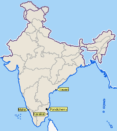
Karaikal is a small coastal enclave of territory which was formerly part of French India. Together with the other former French enclaves of Pondicherry, Yanam, and Mahé, Karaikal forms the Union Territory of Puducherry. Karaikal is bounded on the North and South by Nagapattinam district of Tamil Nadu state, on the west by Tiruvarur district (also belonging to Tamil Nadu), and on the East by the Bay of Bengal. The enclave is located 132 km south of the city of Pondicherry, and is known for its rich cultural heritage.
- 2004 Tsunami
On the 26th of December 2004, Karaikal faced its worst tragedy in recent memory. Tsunami waves hit this coastal town and more than 500 people, mostly fishermen and their families, were washed away by the killer waves.
- Rivers
The main branches of Kaveri below Grand Anicut are the Kodamurutti, Arasalar, Virasolanar and the Vikramanar. Although Arasalar and its branches spread through Karaikal, the waters of Kodamurutti and Virasolanar also meet the irrigation needs of the region
- Topography
Forming part of the fertile Cauveri delta the region is completely covered by the distributaries of Cauveri. Covered completely by a thick mantle of alluvium of variable thickness, the lie of the region is flat having a gentle slope towards the Bay of Bengal in the east. It is limited on the north by the Nandalar and on the south-east by the Vettar. The group of rocks known as Cuddalore formations is met with in the area contiguous to Karaikal region in Nagappattinam District.
Climate[]
Karaikal is situated on the east coast of India, near latitude 11 N in the deltaic region of the Cauveri, experiences tropical maritime type of climate with small daily range of temperature and moderate rainfall. Karaikal has an annual average rainfall of about 126 cm. 68 percent of which occurs during October to December. The amount of rainfall during the south-west monsoon period is small, being less than 20 per cent of the annual. November is the rainiest month, accounting for about a third of the annual total. The range of variation of annual rainfall is wide.
December and January are the coolest months with the maximum at about 28 C and the minimum at about 23C. Minimum temperature as low as 16C may sometimes be recorded. The diurnal ranges of temperature are generally small throughout the year, being highest (about 10C) in May and June, and the least (about 5C) during November to February.
fauna
Among the littoral species tolerating a certain amount of salinity in the soil and in the water, the following five are the most common and remarkable ones : Excoecaria agallocha L (Tam. Tillai), Clerodendrum inerme Gaertn. (Tam. Sangankuppi), Acanthus ilicifolius L. (Tam. Kaludai Mulli), Solanum trilobatum L (Tam. Tudulai), Pandanus tectorius Sol. (Tam. Talai). The trees grown in the area is Palmyra palm, Babul tree, Samutirappalai, Pongam oil tree, Wild date palm.
Demographics[]
According to the 2011 census Karaikal district has a population of 200,314,[3] roughly equal to the nation of Samoa.[4] This gives it a ranking of 589th in India (out of a total of 640).[3] The district has a population density of 1,252 inhabitants per square kilometre (3,240 /sq mi) .[3] Its population growth rate over the decade 2001-2011 was 17.29%.[3] Karaikal has a sex ratio of 1048 females for every 1000 males,[3] and a literacy rate of 87.83%.[3]
Tamil is the principal language spoken and Tamils are the predominant linguistic group in the district. Considerable amount of Sri Lankan Tamils are found in the pockets of Karaikal.
Hindus formed the majority of the population at 75.41% of the population followed by Christians at 10.70%, Muslims at 6.46% and others at 0.12%.[5]
Places of interest[]
Its calm beaches are the prime tourist attraction of Karaikal. Several tourist destinations that lie in neighbouring Tamil Nadu are within easy distance of Karaikal. These include the world famous temple of
- Sri Saneeswara bagavan Temple at Thirunallar(5 km from Karaikal).
- Karaikal Port.
- Karaikal Beach
- Karaikal Ammayar Temple.
- Karaikal Ammaiyar Theppa kulam
- The church of Our Lady of Angels built in 1891.
- Aayiram Kaliamman temple at T.R. Pattinam.
- Bhadrakaliamman Temple at Ambagarattur
- Special Places Near Karaikal
- The famous Abirami amman temple at Thirukadaiyur, 16 km north of Karaikal.
- Singaravelavar temple at Sikkal, 24 km from karaikal.
- The Christian Basilica of Our Lady of Good Health at Velankanni(TN): Famous Christian Pilgrim Shrine, 26 km from Karaikal.
- Nagore Andavar Dargah (TN): Muslim Pilgrim Centre, located 10 km south of Karaikal.
- Danish Fort (TN), Tanquebar. Around 12 km north to Karaikal.
- Tranquebar. The place where first printing press in the world were started by Bartholomew Ziegenbalg, in 1706.
Ten kilometres to the North of Karikal is the former Dutch colony of Tranquebar (Tharangambadi).
Transportation[]
- Air
Nearest Domestic Airport is in Trichy (Trichirapalli). Indian Airlines connects Trichy with Chennai, Sharjah, Kuwait and Colombo. Sri Lankan Airlines Service connects Tiruchirapalli with Colombo and proposed service with Jaffna. Karaikal Airport is being constructed and will be completed by 2014. It will be the first airport in the country to be built entirely with private capital.[6]
- Train
Railway Station Karaikal [7] and railway station at Nagore (15 km from Karaikal).
- Road
Public Transport Many town buses are in operation in this district. They connect tourist places like Tirunallar, Nagore, Nagapattinam, Velankanni, Mayiladuthurai and Thiruvarur in Tamil Nadu State. Many private and public buses with registration of Puducherry union territory and Tamil Nadu state are plying in this region. Long distance buses operated by Tamil Nadu government from Nagapattinam to Chennai via Pondicherry, pass through this place. Government owned bus services and Pondicherry Tourism Development Corporation (PTDC) also runs long distance bus services between Karaikal and Pondicherry
- Port
Karaikal Port Private Limited (KPPL), a private port developed by the Chennai based MARG Limited, became operational in April 2009. The port is located on the Eastern coast of India at keezhavanjore village in Karaikal District of Puducherry, around 300 km along the coast south of Chennai Port and around 360 km along the coast north of Tuticorin Port. The shoreline of the port is between 10o 50’56’’ N and 10o 49’44’’ N.[8]
Loading and unloading of goods are usually carried on with the help of boats whenever water level is high in the river. The goods are brought to the warehouses without difficulty. There are storage facilities in the warehouses situated not far from Arasalar and Vanjiar. However, in view of existence of a port in Nagapattinam, this minor port does not have much importance.
Festivals[]
- Sani Peyarchi Festival
Karaikal is known all over the country for its unique and the only temple devoted to the Lord Saneeswara (Lord Saturn) at Thirunallar. Those who are troubled by vicisitudes in life and wish bright future do spare their time to pay obiesance to the Lord Saturn. The Sani Peyarchi festival is the "Kumb Mela of Pondicherry" attracting lakhs of devotees.
- Mangani Festivals
Although situated within Karaikal municipality, Karaikal Ammayar temple which holds the annual 'Mangani" festival which is a well attended 'Mela', as also Kandoori festival celebrated by Karaikal Darga and the Feast of Our Lady of Lourdes celebrated by Our Lady of Lourdes Church.
- Masi Magam
This annual festival takes place on the full moon day of the Tamil month of Masi (Between February and March). Deities from as many temples in and around Karaikal are brought in ceremonial processions to the seashore for a symbolic immersion ceremony. Thousands of people go to the seashore to have a dip in the sea which is said to wash away one's sins. The most important deity, which takes part in the festival, is Sowriraja Perumal of Thirukannapuram village in Tamil Nadu area. The saying goes that Sowriraja Perumal married a fishermen community woman and hence the moment the deity enters Tirumalairayan-pattinam village of Tirumalairayanpattinam commune for the festival, the fishermen take charge of the deity and charges are replaced after the festival is completed i.e. after the holy bath. This festival is held with all pomp and glory although it cannot be compared to the degree of celebration in Pondicherry.
- Fire-Walking Festivals
Three or four times in a year, local temples conclude their annual festivals with hundreds of men, women and children walking on fire for fulfilment of their vows.
- Kandoori Festival
Kandoori, a popular Muslim festival, is held at Mastan Syed Dawood Dargah in Karaikal. It is celebrated in honor of Syed Dawood, a Sufi saint who came to India in search of his spiritual guide, Halareth Syed Ahamed Kalkhel Diwan Oliulla, and spent his last years in Karaikal.Kandoori Festival is held annually and is marked by processions, music and dance.
Educational institutions[]
Turndowns[]
Unmaintained open drainage system around the town causing foul stink and source for mosquitoes breeding. Solid wastes scattered around roads which makes municipality's existence a big question.
See also[]
- French colonial empire
- French East India Company
- French India
References[]
- ^ http://www.karaikal.com/generalinformation.htm
- ^ Srivastava, Dayawanti et al. (ed.) (2010). "States and Union Territories: Pondicherry: Government". India 2010: A Reference Annual (54th ed.). New Delhi, India: Additional Director General, Publications Division, Ministry of Information and Broadcasting (India), Government of India. pp. 1222. ISBN 978-81-230-1617-7.
- ^ a b c d e f "District Census 2011". Census2011.co.in. 2011. http://www.census2011.co.in/district.php. Retrieved 2011-09-30.
- ^ US Directorate of Intelligence. "Country Comparison:Population". https://www.cia.gov/library/publications/the-world-factbook/rankorder/2119rank.html. Retrieved 2011-10-01. "Samoa 193,161"
- ^ http://www.karaikal.nic.in/Administration/People/MnPeople.htm
- ^ "Coimbatore firm to build India's first private airport in Karaikal". Times of India. 13 March 2012. http://articles.timesofindia.indiatimes.com/2012-03-13/coimbatore/31159347_1_greenfield-airports-private-airport-karaikal. Retrieved 3 July 2012.
- ^ "Nagore-Karaikal BG line inspection by September". The Hindu (Chennai, India). 8 July 2011. http://www.thehindu.com/todays-paper/article2209764.ece?css=print.
- ^ http://www.karaikalport.com/

|
Nagapattinam district, Tamil Nadu (Northern) |
| ||
| Thiruvarur district, Tamil Nadu | Bay of Bengal | |||
 Karaikal district | ||||
| Nagapattinam district, Tamil Nadu (Southern) |
| |||||||||||||||||||||||||||||||||||||||||||||||||||||||||||||||||||||||||||||||||||||||||||||||||||||||||||
| |||||||||||||||||||||||||||||
Template:Proposed states and territories of India
| This page uses content from the English language Wikipedia. The original content was at Karaikal district. The list of authors can be seen in the page history. As with this Familypedia wiki, the content of Wikipedia is available under the Creative Commons License. |