| Main | Births etc |
|---|
| Ilminster | |
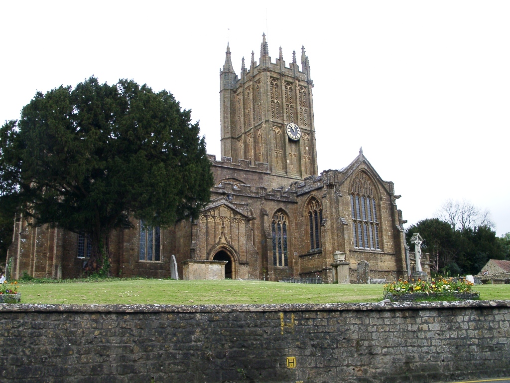 Ilminster's Minster Church |
|
| |
| Population | 5,808 (2011)[1] |
|---|---|
| OS grid reference | |
| District | South Somerset |
| Shire county | Somerset |
| Region | South West |
| Country | England |
| Sovereign state | United Kingdom |
| Post town | ILMINSTER |
| Postcode district | TA19 9 |
| Dialling code | 01460 |
| Police | Avon and Somerset |
| Fire | Devon and Somerset |
| Ambulance | South Western |
| EU Parliament | South West England |
| UK Parliament | Yeovil |
| List of places: UK • England • Somerset | |
Ilminster is a town and civil parish in the countryside of south west Somerset, England, with a population of 5,808.[1] Bypassed in 1988, the town now lies just east of the junction of the A303 (London to Exeter) and the A358 (Taunton to Chard and Axminster). The parish includes the village of Peasmarsh and the hamlet of Sea.
History[]
Ilminster is mentioned in documents dating from 725 and in a Charter granted to the Abbey of Muchelney (10 miles (16 km) to the north) by King Ethelred in 995. Ilminster is also mentioned in the Domesday Book (1086) as Ileminstre meaning 'The church on the River Isle' from the Old English ysle and mynster. By this period Ilminster was a flourishing community and was granted the right to hold a weekly market, which it still does.
Ilminster was part of the hundred of Abdick and Bulstone.[2][3]
In 1645 during the English Civil War Ilminster was the scene of a skirmish between parliamentary troops under Edward Massie and Royalist forces under Lord Goring who fought for control of the bridges prior to the Battle of Langport.[4]
The town contains the buildings of a sixteenth-century grammar school, the Ilminster Meeting House, which acts as the town's art gallery and concert hall. There is also a Gospel Hall.
Governance[]
The parish council has responsibility for local issues, including setting an annual precept (local rate) to cover the council’s operating costs and producing annual accounts for public scrutiny. The parish council evaluates local planning applications and works with the local police, district council officers, and neighbourhood watch groups on matters of crime, security, and traffic. The parish council's role also includes initiating projects for the maintenance and repair of parish facilities, as well as consulting with the district council on the maintenance, repair, and improvement of highways, drainage, footpaths, public transport, and street cleaning. Conservation matters (including trees and listed buildings) and environmental issues are also the responsibility of the council.
The town falls within the Non-metropolitan district of South Somerset, which was formed on 1 April 1974 under the Local Government Act 1972, having previously been part of Chard Rural District[5] and Ilminster Urban District.[6] The district council is responsible for local planning and building control, local roads, council housing, environmental health, markets and fairs, refuse collection and recycling, cemeteries and crematoria, leisure services, parks, and tourism.
Somerset County Council is responsible for running the largest and most expensive local services such as education, social services, libraries, main roads, public transport, policing and fire services, trading standards, waste disposal and strategic planning.
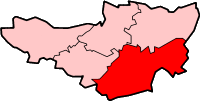
There is an electoral ward of the same name. The ward focuses on Ilminster but also includes Whitelackington. The total population of the ward taken at the 2011 census was 6,017.[7]
It is also part of the Yeovil county constituency represented in the House of Commons of the Parliament of the United Kingdom. It elects one Member of Parliament (MP) by the first past the post system of election, and part of the South West England constituency of the European Parliament which elects six MEPs using the d'Hondt method of party-list proportional representation.
Geography[]
Ilminster is close to the River Isle and the A303 road.
Climate[]
Along with the rest of South West England, Ilminster has a temperate climate which is generally wetter and milder than the rest of the country.[8] The annual mean temperature is approximately 10 °C (50.0 °F). Seasonal temperature variation is less extreme than most of the United Kingdom because of the adjacent sea temperatures. The summer months of July and August are the warmest with mean daily maxima of approximately 21 °C (69.8 °F). In winter mean minimum temperatures of 1 °C (33.8 °F) or 2 °C (35.6 °F) are common.[8] In the summer the Azores high pressure affects the south-west of England, however convective cloud sometimes forms inland, reducing the number of hours of sunshine. Annual sunshine rates are slightly less than the regional average of 1,600 hours.[8] In December 1998 there were 20 days without sun recorded at Yeovilton. Most the rainfall in the south-west is caused by Atlantic depressions or by convection. Most of the rainfall in autumn and winter is caused by the Atlantic depressions, which is when they are most active. In summer, a large proportion of the rainfall is caused by sun heating the ground leading to convection and to showers and thunderstorms. Average rainfall is around 700 mm (28 in). About 8–15 days of snowfall is typical. November to March have the highest mean wind speeds, and June to August have the lightest winds. The predominant wind direction is from the south-west.[8]
Church[]
Ilminster takes its name from the River Isle and its large church of St Mary, which is known as The Minster. The Hamstone building dates from the 15th century, but was refurbished in 1825 by William Burgess and the chancel restored in 1883. Further restoration took place in 1887-89 and 1902. Among the principal features are the Wadham tombs; those of Sir William Wadham and his mother, dated 1452 and Nicholas and Dorothy Wadham 1609 and 1618.
The tower rises two storeys above the nave. It has three bays, with a stair turret to the north-west corner. The bays are articulated by slender buttresses with crocketed finials above the castellated parapet. Each bay on both stages contains a tall two-light mullioned-and-transomed window with tracery. The lights to the top are filled with pierced stonework; those to the base are solid. The stair turret has string courses coinciding with those on the tower, and a spirelet with a weathervane. It contains a bell dating from 1732 made by Thomas Bilbie and another from 1790 made by William Biblie of the Bilbie family.[9] The church has been designated by English Heritage as a Grade I listed building.[10]
Shopping[]


Bicycle messenger of Royal mail in Ilminster
The town has a selection of shops including a traditional Edwardian-style clothing and soft furnishings store called Dyers. A Tesco store opened in November 2007.
In November the town celebrates the lighting of the Christmas lights with a Victorian evening. This is normally accompanied by local shops serving rum and cakes.
Transport[]
Ilminster used to have a station on the Chard Branch Line but this closed in 1962. There were also some sidings, to allow trains going in opposite directions to pass each other.
Twinnings[]
Ilminster is twinned with Riec-sur-Belon in France.[11]
Notable people[]
See also Category:People from Ilminster
- John Baker born in Ilminster before emigrating to Australia and becoming the Premier of South Australia.
- Charles Moore, the geologist, was born in Ilminster.
References[]
- ^ a b "Statistics for Wards, LSOAs and Parishes — SUMMARY Profiles" (Excel). Somerset Intelligence. http://www.somersetintelligence.org.uk/files/Somerset%20Census%20Key%20Statistics%20-%20Summary%20Profiles.xls. Retrieved 4 January 2014.
- ^ "Abdick and Bulstone Hundred Through Time". A Vision of Britain Through Time. http://www.visionofbritain.org.uk/relationships.jsp?u_id=10133830. Retrieved 9 September 2011.
- ^ "Abdick and Bulstone in South Somerset". A Vision Britain Through Time. http://www.visionofbritain.org.uk/place/place_page.jsp?p_id=21175. Retrieved 9 September 2011.
- ^ Barratt, John (2005). The civil war in the south west. Bernsley: Pen & Sword Military. pp. 116–118. ISBN 1-84415-146-8.
- ^ "Chard RD". A vision of Britain Through Time. University of Portsmouth. http://www.visionofbritain.org.uk/unit/10001535. Retrieved 4 January 2014.
- ^ "Ilminster UD". A vision of Britain Through Time. University of Portsmouth. http://www.visionofbritain.org.uk/unit/10135291. Retrieved 8 January 2014.
- ^ "Ward population 2011.Revised 4 March 2015". http://www.ukcensusdata.com/ilminster-e05006836#sthash.ylCvymET.dpbs.
- ^ a b c d "South West England: climate". Met Office. http://www.metoffice.gov.uk/climate/uk/sw/. Retrieved 14 March 2010.
- ^ Moore, James; Rice, Roy; Hucker, Ernest (1995). Bilbie and the Chew Valley clock makers. The authors. ISBN 0-9526702-0-8.
- ^ "Parish Church of St Mary". Images of England. http://www.imagesofengland.org.uk/details/default.aspx?id=383479. Retrieved 6 October 2007.
- ^ "French visitors bag twinning gift". thisissomerset.co.uk. 8 June 2009. http://www.thisisthewestcountry.co.uk/news/somerset_news/4416444.French_visitors_bag_twinning_gift/. Retrieved 22 February 2010.
External links[]
- Ilminster at the Open Directory Project
- The Somerset Urban Archaeological Survey: Ilminster, by Clare Gathercole
- Ilminster's Community Website
- Visit Ilminster
| |||||||
| ||||||||||||||||||||
| This page uses content from the English language Wikipedia. The original content was at Ilminster. The list of authors can be seen in the page history. As with this Familypedia wiki, the content of Wikipedia is available under the Creative Commons License. |