| ||||||||||||||
| Hyde County, North Carolina | ||
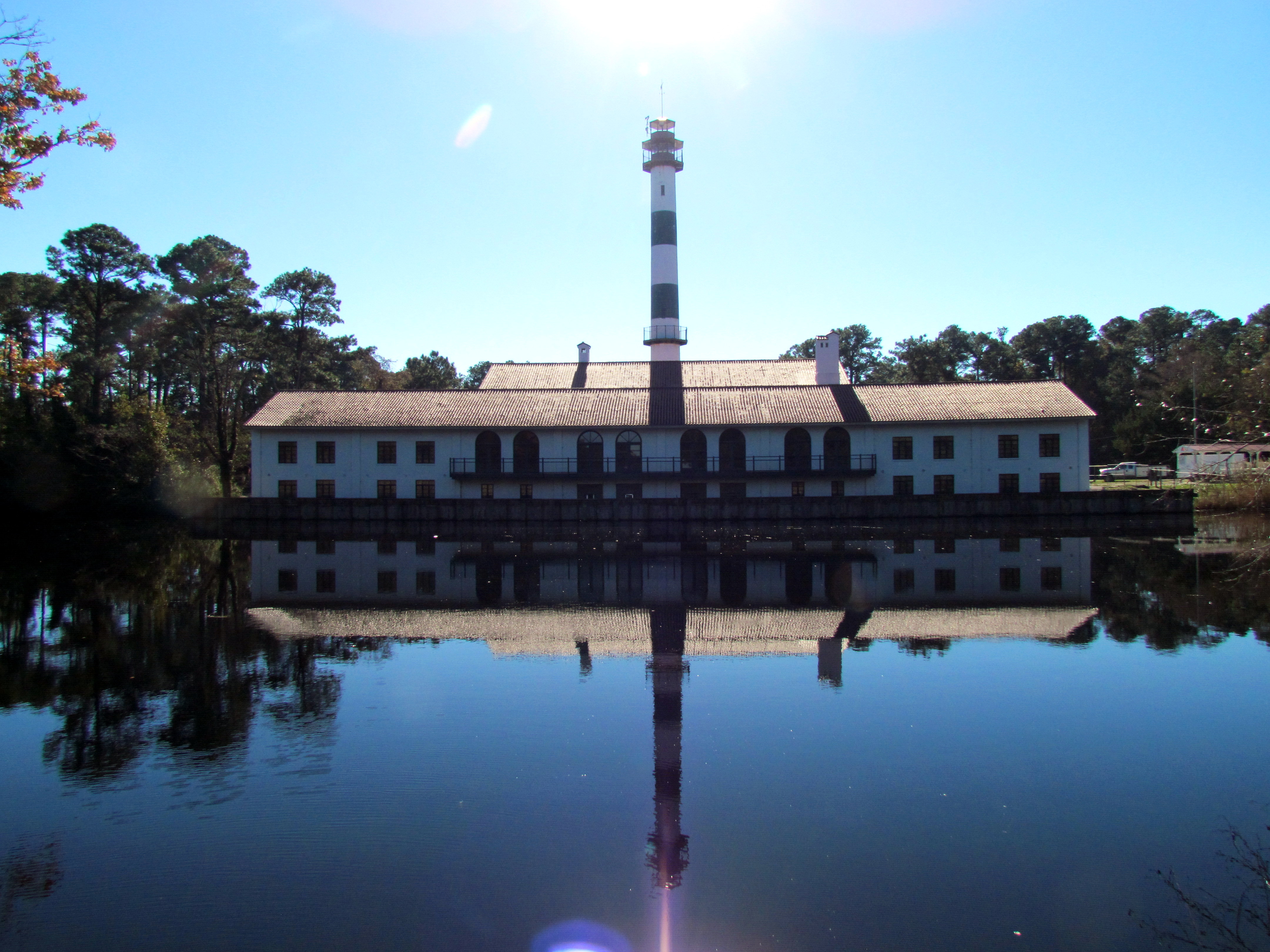 Lake Mattamuskeet Pump Station at the Mattamuskeet National Wildlife Refuge near Swan Quarter.
| ||
| ||
 Location in the state of North Carolina | ||
 North Carolina's location in the U.S. | ||
| Founded | 1739 | |
|---|---|---|
| Named for | Edward Hyde | |
| Seat | Swan Quarter | |
| Largest community | Ocracoke | |
| Area - Total - Land - Water |
1,424 sq mi (3,688 km²) 613 sq mi (1,588 km²) 811 sq mi (2,100 km²), 57% | |
| Population - (2020) - Density |
4,589 7.4/sq mi (3/km²) | |
| Congressional district | 3rd | |
| Time zone | Eastern: UTC-5/-4 | |
| Website | www.hydecountync.gov | |
Hyde County is a county located in the U.S. state of North Carolina. As of the 2020 Census, the population was 4,589,[1] making it the second-least populous county in North Carolina.[2] Its county seat is Swan Quarter.[3] The county was created in 1705 as Wickham Precinct. It was renamed Hyde Precinct in 1712 and gained county status in 1739.[4][5]
History[]
The county was formed December 3, 1705, as Wickham Precinct, one of three precincts within Bath County. The name "Wickham" was derived from the manor of "Temple Wycombe" in Buckinghamshire, England, the family home of John Archdale, Governor of North and South Carolina from 1695 to 1696. In 1712 it was renamed Hyde Precinct, for Edward Hyde,[6] Governor of North Carolina from 1711 to 1712. In 1739 Bath County was abolished, and Hyde Precinct became Hyde County.
Various boundary changes have since taken place. In 1745 Lake Mattamuskeet and its adjoining territory were transferred from Currituck County to Hyde County. In 1819 the portion of Hyde County west of the Pungo River was annexed by Beaufort County. Four years later, the area of Currituck County south of New Inlet was transferred to Hyde County. This is now included Hatteras Island. In 1845 Ocracoke Island was transferred from Carteret County to Hyde County. In 1870 Hyde County was reduced to its present dimensions, when its northeastern part was combined with parts of Currituck County and Tyrrell County to form Dare County. Since its creation, the boundaries of Hyde County have changed more than those of any other county in North Carolina.
Geography[]
According to the U.S. Census Bureau, the county has a total area of 1,424 square miles (3,690 km2), of which 613 square miles (1,590 km2) is land and 811 square miles (2,100 km2) (57%) is water.[7] It is the second-largest county in North Carolina by total area. Hyde County's in-land is part of the Inner Banks. Ocracoke Island is part of the Outer Banks.
Adjacent counties[]
- Tyrrell County - north
- Dare County - northeast
- Carteret County - southwest
- Pamlico County - south
- Beaufort County - west
- Washington County - northwest
National protected areas[]
- Alligator River National Wildlife Refuge (part)
- Cape Hatteras National Seashore (part)
- Mattamuskeet National Wildlife Refuge
- Pocosin Lakes National Wildlife Refuge (part)
- Swanquarter National Wildlife Refuge
State and locale protected areas[]
- Dare Game Land (part)
- Emily and Richardson Preyer Buckridge Reserve (part)
- Gull Rock Game Land
- Hatteras Inlet Crab Spawning Sanctuary (part)
- New Lake Game Land (part)
Major water-bodies[]
- Alligator Lake
- Alligator River
- Intracoastal Waterway
- Lake Mattamuskeet
- Pamlico River
- Pamlico Sound
- Pungo Lake
- Pungo River
- Atlantic Ocean
Major highways[]
 US 264
- NC 12
- NC 45
- NC 94
- NC 99
Other major infrastructure[]
- Cedar Island-Ocracoke Ferry
- Hatteras-Ocracoke Ferry
- Swan Quarter-Ocracoke Ferry
Hyde County is one of the most rural counties in North Carolina, owing this to its low population, absence of four-lane highways, and even the absence of stoplights in the county.
Demographics[]
| Historical populations | |||
|---|---|---|---|
| Census | Pop. | %± | |
| 1790 | 4,204 | ||
| 1800 | 4,829 | 14.9% | |
| 1810 | 6,029 | 24.8% | |
| 1820 | 4,967 | −17.6% | |
| 1830 | 6,184 | 24.5% | |
| 1840 | 6,458 | 4.4% | |
| 1850 | 7,636 | 18.2% | |
| 1860 | 7,732 | 1.3% | |
| 1870 | 6,445 | −16.6% | |
| 1880 | 7,765 | 20.5% | |
| 1890 | 8,903 | 14.7% | |
| 1900 | 9,278 | 4.2% | |
| 1910 | 8,840 | −4.7% | |
| 1920 | 8,386 | −5.1% | |
| 1930 | 8,550 | 2.0% | |
| 1940 | 7,860 | −8.1% | |
| 1950 | 6,479 | −17.6% | |
| 1960 | 5,765 | −11.0% | |
| 1970 | 5,571 | −3.4% | |
| 1980 | 5,873 | 5.4% | |
| 1990 | 5,411 | −7.9% | |
| 2000 | 5,826 | 7.7% | |
| 2010 | 5,810 | −0.3% | |
| Est. 2021 | 4,508 | [8] | −22.6% |
| U.S. Decennial Census[9] 1790-1960[10] 1900-1990[11] 1990-2000[12] 2010-2020[13] | |||
2020 census[]
| Race | Number | Percentage |
|---|---|---|
| White (non-Hispanic) | 2,928 | 63.8% |
| Black or African American (non-Hispanic) | 1,152 | 25.1% |
| Native American | 7 | 0.15% |
| Asian | 7 | 0.15% |
| Pacific Islander | 2 | 0.04% |
| Other/Mixed | 146 | 3.18% |
| Hispanic or Latino | 347 | 7.56% |
As of the 2020 United States census, there were 4,589 people, 1,947 households, and 1,378 families residing in the county.
2000 census[]
As of the census[15] of 2000, there were 5,826 people, 2,185 households, and 1,433 families residing in the county. The population density was 10 people per square mile (4/km2). There were 3,302 housing units at an average density of 5 per square mile (2/km2). The racial makeup of the county was 62.65% White, 35.07% Black or African American, 0.31% Native American, 0.36% Asian, 0.84% from other races, and 0.77% from two or more races. 2.25% of the population were Hispanic or Latino of any race.
There were 2,185 households, out of which 26.40% had children under the age of 18 living with them, 48.70% were married couples living together, 13.10% had a female householder with no husband present, and 34.40% were non-families. 30.60% of all households were made up of individuals, and 13.90% had someone living alone who was 65 years of age or older. The average household size was 2.36 and the average family size was 2.94.
In the county, the population was spread out, with 20.40% under the age of 18, 7.90% from 18 to 24, 30.70% from 25 to 44, 24.60% from 45 to 64, and 16.40% who were 65 years of age or older. The median age was 40 years. For every 100 females there were 112.20 males. For every 100 females age 18 and over, there were 115.60 males.
The median income for a household in the county was $28,444, and the median income for a family was $35,558. Males had a median income of $25,216 versus $20,482 for females. The per capita income for the county was $13,164. About 10.30% of families and 15.40% of the population were below the poverty line, including 19.50% of those under age 18 and 23.00% of those age 65 or over.
Law and government[]
Hyde County is a member of the Albemarle Commission regional council of governments.
Hyde County is served by six volunteer fire departments: Engelhard, Fairfield, Ocracoke, Scranton, Ponzer, and Swan Quarter.
Politics[]
Hyde County is located within North Carolina's 3rd congressional district. In the 2008 Presidential election, the county was narrowly divided, much like the rest of the state of North Carolina, with Barack Obama winning 1,241 votes, John McCain winning 1,212 votes, and other candidates winning 16 votes.[16]
| Year | Republican | Democratic | Third party | |||
|---|---|---|---|---|---|---|
| No. | % | No. | % | No. | % | |
| 2020 | 1,418 | 56.90% | 1,046 | 41.97% | 28 | 1.12% |
| 2016 | 1,288 | 55.90% | 965 | 41.88% | 51 | 2.21% |
| 2012 | 1,193 | 50.06% | 1,163 | 48.80% | 27 | 1.13% |
| 2008 | 1,212 | 49.09% | 1,241 | 50.26% | 16 | 0.65% |
| 2004 | 1,235 | 53.86% | 1,048 | 45.70% | 10 | 0.44% |
| 2000 | 1,132 | 50.60% | 1,088 | 48.64% | 17 | 0.76% |
| 1996 | 782 | 38.30% | 1,109 | 54.31% | 151 | 7.39% |
| 1992 | 740 | 32.34% | 1,206 | 52.71% | 342 | 14.95% |
| 1988 | 940 | 41.52% | 1,316 | 58.13% | 8 | 0.35% |
| 1984 | 1,195 | 54.27% | 1,004 | 45.59% | 3 | 0.14% |
| 1980 | 807 | 38.95% | 1,221 | 58.93% | 44 | 2.12% |
| 1976 | 623 | 36.28% | 1,084 | 63.13% | 10 | 0.58% |
| 1972 | 1,112 | 71.97% | 403 | 26.08% | 30 | 1.94% |
| 1968 | 401 | 20.02% | 769 | 38.39% | 833 | 41.59% |
| 1964 | 514 | 31.32% | 1,127 | 68.68% | 0 | 0.00% |
| 1960 | 481 | 29.55% | 1,147 | 70.45% | 0 | 0.00% |
| 1956 | 491 | 32.32% | 1,028 | 67.68% | 0 | 0.00% |
| 1952 | 406 | 30.64% | 919 | 69.36% | 0 | 0.00% |
| 1948 | 214 | 20.34% | 800 | 76.05% | 38 | 3.61% |
| 1944 | 323 | 25.90% | 924 | 74.10% | 0 | 0.00% |
| 1940 | 309 | 20.45% | 1,202 | 79.55% | 0 | 0.00% |
| 1936 | 302 | 20.70% | 1,157 | 79.30% | 0 | 0.00% |
| 1932 | 147 | 12.24% | 1,050 | 87.43% | 4 | 0.33% |
| 1928 | 682 | 53.62% | 590 | 46.38% | 0 | 0.00% |
| 1924 | 305 | 31.31% | 653 | 67.04% | 16 | 1.64% |
| 1920 | 530 | 31.85% | 1,134 | 68.15% | 0 | 0.00% |
| 1916 | 277 | 24.64% | 840 | 74.73% | 7 | 0.62% |
| 1912 | 76 | 7.51% | 636 | 62.85% | 300 | 29.64% |
| 1908 | 223 | 25.20% | 662 | 74.80% | 0 | 0.00% |
| 1904 | 318 | 34.12% | 614 | 65.88% | 0 | 0.00% |
| 1900 | 798 | 47.87% | 867 | 52.01% | 2 | 0.12% |
| 1896 | 847 | 45.34% | 1,019 | 54.55% | 2 | 0.11% |
| 1892 | 430 | 26.27% | 858 | 52.41% | 349 | 21.32% |
| 1888 | 771 | 47.59% | 843 | 52.04% | 6 | 0.37% |
| 1884 | 671 | 43.23% | 881 | 56.77% | 0 | 0.00% |
| 1880 | 609 | 42.65% | 819 | 57.35% | 0 | 0.00% |
Earl Pugh is chairman of the Hyde County Commissioners.
Education[]
Hyde County is home to the smallest public school system in North Carolina. The Hyde County Schools comprises two schools.
- Mattamuskeet School, K-12 serves the mainland
- Ocracoke School, K-12 serves Ocracoke Island
The only private school in Hyde County is a small Mennonite school located in the northwest section of the county. This school serves the county's Mennonite population.
Media[]
Hyde County is home to two full power radio stations, WKHC 97.1 FM and WCMS-FM 94.5. These stations are licensed to Hatteras, NC but maintain transmitter facilities outside of Engelhard.
Ocracoke Island is home to WOVV 90.1 FM, a low power non-commercial station.
WHYC 88.5 FM is located on the campus of Mattamuskeet School in Swan Quarter. WHYC is one of only two high school operated stations in North Carolina.
Communities[]


Map of Hyde County, North Carolina With Municipal and Township Labels
Hyde County has no incorporated municipalities.
Census-designated places[]
- Engelhard
- Fairfield
- Ocracoke
- Swan Quarter (county seat)
Unincorporated communities[]
- Germantown
- Last Chance
- Nebraska
- Scranton
- Ponzer
Townships[]
- Currituck
- Fairfield
- Lake Landing
- Ocracoke (largest community)
- Swan Quarter
A sixth township, Mattamuskeet, is now "unorganized territory" occupied by the federally controlled Mattamuskeet National Wildlife Refuge.
See also[]
- National Register of Historic Places listings in Hyde County, North Carolina
- North Carolina Ferry System
- Blackbeard was killed after a battle on his ship the Queen Anne's Revenge near Ocracoke.
- National Park Service
References[]
- ^ "U.S. Census Bureau QuickFacts: Hyde County, North Carolina" (in en). https://www.census.gov/quickfacts/fact/table/hydecountynorthcarolina/PST045221.
- ^ "North Carolina Population by County" (in en). http://www.indexmundi.com/facts/united-states/quick-facts/north-carolina/population#chart.
- ^ "Find a County". National Association of Counties. http://www.naco.org/Counties/Pages/FindACounty.aspx.
- ^ "North Carolina: Individual County Chronologies". North Carolina Atlas of Historical County Boundaries. The Newberry Library. 2009. http://publications.newberry.org/ahcbp/documents/NC_Individual_County_Chronologies.htm.
- ^ "Hyde County". State Library of North Carolina. January 1, 2006. http://ncpedia.org/geography/hyde.
- ^ Gannett, Henry (1905). The Origin of Certain Place Names in the United States. Govt. Print. Off.. pp. 164. https://archive.org/details/bub_gb_9V1IAAAAMAAJ.
- ^ "2010 Census Gazetteer Files". United States Census Bureau. August 22, 2012. https://www.census.gov/geo/maps-data/data/docs/gazetteer/counties_list_37.txt.
- ^ "U.S. Census Bureau QuickFacts: Hyde County, North Carolina.". www.census.gov.. https://www.census.gov/quickfacts/fact/table/hydecountynorthcarolina/PST045221.
- ^ "U.S. Decennial Census". United States Census Bureau. https://www.census.gov/programs-surveys/decennial-census.html.
- ^ "Historical Census Browser". University of Virginia Library. http://mapserver.lib.virginia.edu.
- ^ Forstall, Richard L., ed (March 27, 1995). "Population of Counties by Decennial Census: 1900 to 1990". United States Census Bureau. https://www.census.gov/population/cencounts/nc190090.txt.
- ^ "Census 2000 PHC-T-4. Ranking Tables for Counties: 1990 and 2000". United States Census Bureau. April 2, 2001. https://www.census.gov/population/www/cen2000/briefs/phc-t4/tables/tab02.pdf.
- ^ "State & County QuickFacts". United States Census Bureau. http://quickfacts.census.gov/qfd/states/37/37095.html.
- ^ "Explore Census Data". https://data.census.gov/cedsci/table?g=0500000US37095&tid=DECENNIALPL2020.P2.
- ^ "U.S. Census website". United States Census Bureau. https://www.census.gov.
- ^ "Presidential General Election Results - Hyde County, NC." Atlas of U.S. Presidential Elections. Retrieved 2010-04-10.
- ^ Leip, David. "Dave Leip's Atlas of U.S. Presidential Elections". http://uselectionatlas.org/RESULTS.

|
Washington County | Tyrrell County | Dare County |
|
| Beaufort County | Dare County | |||
 Hyde County, North Carolina | ||||
| Carteret County | Pamlico Sound | Pamlico Sound |
| ||||||||||||||

| ||||||||||||||||||||||
|
| This page uses content from the English language Wikipedia. The original content was at Hyde County, North Carolina. The list of authors can be seen in the page history. As with this Familypedia wiki, the content of Wikipedia is available under the Creative Commons License. |