| Main | Births etc |
|---|
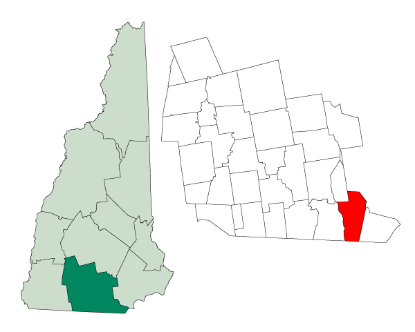
| Hudson, New Hampshire | |||
|---|---|---|---|
| — Town — | |||
|
|||
 |
|||
| Coordinates: Coordinates: | |||
| Country | United States | ||
| State | New Hampshire | ||
| County | Hillsborough | ||
| Incorporated | 1673 | ||
| Annexed | 1731 | ||
| Incorporated | 1746 (renamed in 1830) | ||
| Government | |||
| • Board of Selectmen | Rick Maddox, Chair Nancy Brucker Roger E. Coutu Ben Nadeau Thaddeus Luszey |
||
| Area | |||
| • Total | 29.12 sq mi (75.3 km2) | ||
| • Land | 28.3 sq mi (73.2 km2) | ||
| • Water | 0.8 sq mi (2.1 km2) | ||
| Elevation | 148 ft (45 m) | ||
| Population (2010) | |||
| • Total | 24,467 | ||
| • Density | 840/sq mi (320/km2) | ||
| Time zone | EST (UTC-5) | ||
| • Summer (DST) | EDT (UTC-4) | ||
| ZIP code | 03051 | ||
| Area code(s) | 603 | ||
| FIPS code | 33-37940 | ||
| GNIS feature ID | 0873631 | ||
| Website | hudsonnh.gov | ||
Hudson is a town in Hillsborough County, New Hampshire, United States. The population was 24,467 at the 2010 census.[1]
The primary settlement in town, where 7,336 people resided at the 2010 census,[1] is defined as the Hudson census-designated place (CDP) and is located at the junctions of New Hampshire routes 102, 111 and 3A, directly across the Merrimack River from the city of Nashua.
History[]
Hudson began as part of the Dunstable Land Grant that encompassed the current city of Nashua, New Hampshire, and the towns of Dunstable and Pepperell, Massachusetts, as well as parts of other nearby towns on both sides of the border. In 1732, all of Dunstable east of the Merrimack River became the town of Nottingham, Massachusetts. Nine years later, the northern boundary of Massachusetts was finally officially established, and the New Hampshire portion of Nottingham became Nottingham West, to avoid confusion with Nottingham, New Hampshire to the northeast.[2]
In 1830, after the better part of a century, the name was changed to "Hudson" to avoid confusion with the older town of Nottingham. The name apparently comes from an early belief that the Merrimack River had once been thought to be a tributary of the Hudson River, or that the area had once been explored by Henry Hudson; both proved to be entirely apocryphal stories, but the name of the town remains today.
A prominent family in Hudson history was the Alfred and Virginia Hills family, who owned a large tract of land north of Hudson Village. Dr. Hills' ancestors were original settlers of Hudson.[3] The Hills House on Derry Road (now listed on the National Register of Historic Places) is their original family's vacation home and current location of the Town Historical Society. The grounds host the annual "Old Home Days" fair every year as well as "Harvest Fest" and the "Bronco Belly Bustin' Chili Fiesta", an Alvirne High School Friends of Music fundraiser. Hills Memorial Library (also listed on the National Register) is one of the oldest public lending libraries in the state, and occupies a stone and mortar building on Library Street. Alvirne High School and the Alvirne Chapel, located on family land across Derry Road from the Hills House, were donated to the town. (Alvirne is a contraction of Alfred and Virginia). A strange rumor that The Hills' only son had died during a football game circled for many years, but Dr. and Mrs. Hills only had two daughter who did not survive infancy, so this was a made up story. Out of respect, Alvirne High went many decades without a football team, despite being one of the largest high schools in the state. It was assumed that such a stipulation had been put as a condition of the high school's charter. When it was learned that no such condition had ever been recorded, financial pressures encouraged the formation of a football team. In fall of 1994, Alvirne High School fielded its first JV football team, with varsity play beginning in 1996. Alvirne High is home to one of the largest agricultural-vocational programs in the area, the Wilbur H. Palmer Agricultural and Vocational School. This school features several student-run businesses including a bank, restaurant, store, day care, dairy farm, and forestry program.
Geography[]
According to the United States Census Bureau, the town has a total area of 29.1 square miles (75 km2), of which 28.3 sq mi (73 km2) is land and 0.8 sq mi (2.1 km2) is water, comprising 2.82% of the town. The town center, or census-designated place (CDP), has a total area of 3.2 sq mi (8.3 km2), of which 3.1 sq mi (8.0 km2) is land and 0.2 sq mi (0.52 km2) (4.95%) is water.
The highest point in Hudson is Bush Hill, at 515 feet (157 m) above sea level, near the town's eastern border. Hudson lies fully within the Merrimack River watershed.[4]
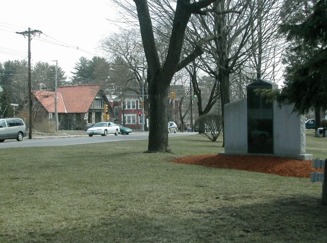
Hudson Town Common with Hills Memorial Library in background
The Town of Hudson had two historic town centers, though modern development and suburban sprawl have obscured the difference. Hudson Village, roughly equivalent to the Hudson census-designated place, is located on the Merrimack River near the junctions of Routes 3A, 111, and 102, and is home to most of the original schools, libraries, and town government. The Town Hall, the Hills Memorial Library, and the Kimball Webster School (which today houses the superintendent's office) are all located in Hudson Village. The Town Common at the intersection of Derry, Ferry, and Library streets is a park that displays large toy soldiers and other decorations at Christmas time.
Hudson Center, historically Hudson's other town center, is located at the 5-way intersection of Central Street (Route 111), Greeley Street, Kimball Hill Road, and Windham Road. The two most important landmarks of Hudson Center have been lost to history. Benson's Wild Animal Farm, a zoo & amusement park, was closed in the late 1980s due to mounting financial losses. At one time there was a railway that passed through the Center, taking passengers all the way from the Boston area to Benson's. A rail depot stand remained on nearby Greeley Street through the 1970s. The acreage of Benson's Wild Animal Farm was purchased by the Town of Hudson and is now a park for passive recreation. The other landmark, Thompson's Market, closed in 2002 when Mr. Thompson decided to sell his store and retire to Florida. The structure still remains, but it was remodeled and reopened as a 7-Eleven convenience store. The original Thompson's Market is nearby also, a small building on Kimball Hill Road now home to a popular sandwich shop. Greeley Field, a popular park located in Hudson Center, contains a playground, little league baseball diamond, and basketball courts, where pick-up games still occur frequently. A Revolutionary War era cemetery and an old school house (now housing) on Kimball Hill Road are located nearby.
Neighboring towns and cities[]

|
Merrimack | Litchfield, Londonderry | Windham |
|
| Nashua | Pelham | |||
 Hudson | ||||
| Tyngsborough, Massachusetts |
Demographics[]
As of the census[5] of 2000, there were 22,928 people, 8,034 households, and 6,258 families residing in the town. The population density was 811.2 people per square mile (313.1/km²). There were 8,165 housing units at an average density of 288.9 per square mile (111.5/km²). The racial makeup of the town was 96.35% White, 0.84% Black or African American, 0.15% Native American, 1.11% Asian, 0.06% Pacific Islander, 0.55% from other races, and 0.95% from two or more races. Hispanic or Latino of any race were 1.55% of the population.
There were 8,034 households out of which 41.0% had children under the age of 18 living with them, 64.8% were married couples living together, 9.0% had a female householder with no husband present, and 22.1% were non-families. 16.3% of all households were made up of individuals and 4.0% had someone living alone who was 65 years of age or older. The average household size was 2.83 and the average family size was 3.17.
In the town the population was spread out with 28.2% under the age of 18, 6.3% from 18 to 24, 35.3% from 25 to 44, 22.3% from 45 to 64, and 7.9% who were 65 years of age or older. The median age was 35 years. For every 100 females there were 97.9 males. For every 100 females age 18 and over, there were 95.6 males.
The median income for a household in the town was $64,169, and the median income for a family was $71,313. Males had a median income of $46,198 versus $31,315 for females. The per capita income for the town was $25,696. About 1.2% of families and 2.3% of the population were below the poverty line, including 1.9% of those under age 18 and 4.2% of those age 65 or over.
In 2006, the U.S. Census bureau released a new estimate for the town population, at 24,729, making it the 10th largest city or town in New Hampshire.[2]
Town center[]
As of the census[5] of 2000, there were 7,814 people, 3,063 households, and 2,107 families residing in the Hudson census-designated place (CDP). The population density was 2,549.5 people per square mile (985.9/km²). There were 3,125 housing units at an average density of 1,019.6 per square mile (394.3/km²). The racial makeup of the CDP was 95.74% White, 1.23% Black or African American, 0.26% Native American, 1.11% Asian, 0.82% from other races, and 0.84% from two or more races. Hispanic or Latino of any race were 2.32% of the population.
There were 3,063 households out of which 33.3% had children under the age of 18 living with them, 52.4% were married couples living together, 11.2% had a female householder with no husband present, and 31.2% were non-families. 24.2% of all households were made up of individuals and 6.9% had someone living alone who was 65 years of age or older. The average household size was 2.55 and the average family size was 3.02.
In the CDP the population was spread out with 24.6% under the age of 18, 7.6% from 18 to 24, 35.8% from 25 to 44, 21.8% from 45 to 64, and 10.3% who were 65 years of age or older. The median age was 35 years. For every 100 females there were 97.8 males. For every 100 females age 18 and over, there were 95.4 males.
The median income for a household in the CDP was $49,753, and the median income for a family was $58,836. Males had a median income of $37,839 versus $27,696 for females. The per capita income for the CDP was $22,324. About 1.2% of families and 3.8% of the population were below the poverty line, including 1.8% of those under age 18 and 4.9% of those age 65 or over.
Education[]

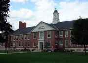
Alvirne High School
Hudson is the home of School Administrative Unit #81 of New Hampshire.
- High School (grades 9th-12th):
- Alvirne High School, which is also home to the Wilbur H. Palmer Vocational-Technical Center, a business-oriented vocational school.
- Middle school (grades 6th-8th):
- Hudson Memorial School
- Elementary schools (grades 1st-5th):
- Dr. H. O. Smith School
- Library Street School
- Hills-Garrison School
- Nottingham West Elementary School
- Public kindergarten was offered for the first time beginning with the 2009/2010 school year. Portable classrooms were added to Hills Garrison, Nottingham West and Library Street schools. Hudson had been one of the last school districts in the state that did not offer public kindergarten.
- Private: Presentation of Mary Academy ("PMA" locally) is a Pre-K-8 private coeducational Catholic school located on Lowell Road.
Economy[]
Hudson serves primarily as a "bedroom community" for the Greater Boston metropolitan area of which it is a part. In 2006, for example, there were an estimated 10,945 jobs in the public and private sector in Hudson, while the town's population was 24,729, with a civilian labor force of 14,818. The town's three largest employers are Benchmark Electronics, BAE Systems, and the Hudson School District.[2] Presstek is also headquartered about one mile south of Hudson.
Sites of interest[]
Two small recreational lakes exist within the town borders. Robinson (or Robinson's) Pond in the northern part of the town features a public access beach and boat ramp that can be accessed via Robinson Road. Otternic Pond (locally called "Tonic Pond"), located between Hudson Center and Hudson Village, has a public boat landing (Claveau Landing) that can be accessed off Highland Street. Both ponds are often used for fishing during the summer and skating and ice hockey during the winter. Musquash Pond (or Swamp), located in the southern part of the town, is a wild bird sanctuary and is utilized as a breeding ground by several threatened and endangered species of birds. In the early 1900s hunters would travel by horse from as far as Derry to camp and stalk game in the renowned swamp.
Hills Memorial Library, located in Hudson Village, is one of the oldest public lending libraries in the state, and is listed on the National Register of Historic Places.
Two public golf courses exist in Hudson, the Whip-Poor-Will Golf Club off Route 102 and the Green Meadow Golf Club on Steele Road (off Route 3A/Lowell Road).
A 1/4 mile paved racetrack, the Hudson Speedway, lies near the northern edge of town by the intersection of Old Derry Road and Robinson Road. It can be accessed off Route 102.
References[]
- ^ a b United States Census Bureau, American FactFinder, 2010 Census figures. Retrieved March 23, 2011.
- ^ a b c "Hudson, NH". Town Profile. Economic and Labor Market Information Bureau, New Hampshire Employment Security. 2007. http://www.nh.gov/nhes/elmi/htmlprofiles/hudson.html. Retrieved 2008-04-24.
- ^ For more information, see Kimball Webster's History of Hudson, NH, the 1977 update, or Images of America-Hudson, NH by Laurie Jasper.
- ^ Foster, Debra H.; Batorfalvy, Tatianna N.; and Medalie, Laura (1995). Water Use in New Hampshire: An Activities Guide for Teachers. U.S. Department of the Interior and U.S. Geological Survey. http://nh.water.usgs.gov/Publications/nh.intro.html.
- ^ a b "American FactFinder". United States Census Bureau. http://factfinder.census.gov. Retrieved 2008-01-31.
External links[]
- Town of Hudson official website
- New Hampshire Economic and Labor Market Information Bureau Profile
- Nashua Regional Planning Commission
| |||||||||||||||||

| |||||||||||||||||||||||
| This page uses content from the English language Wikipedia. The original content was at Hudson, New Hampshire. The list of authors can be seen in the page history. As with this Familypedia wiki, the content of Wikipedia is available under the Creative Commons License. |