| Main | Births etc |
|---|
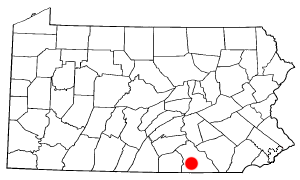
| Hanover, Pennsylvania | |||
|---|---|---|---|
| — Borough — | |||
 |
|||
|
|||
| Nickname(s): Black Rose Community, Snack Capital, Rogue's Roost | |||
| Motto: Fiat Justitia (Let Justice be Done) | |||
 |
|||
| Coordinates: Coordinates: | |||
| Country | United States | ||
| State | Pennsylvania | ||
| County | York | ||
| Founded Incorporated |
1730 1815 |
||
| Government | |||
| • Mayor | Ben Adams | ||
| Area | |||
| • Total | 3.7 sq mi (9.5 km2) | ||
| • Land | 3.7 sq mi (9.5 km2) | ||
| • Water | 0 sq mi (0 km2) | ||
| Population (2010) | |||
| • Total | 15,289 | ||
| • Density | 3,982/sq mi (1,537.5/km2) | ||
| Time zone | Eastern (UTC-5) | ||
| • Summer (DST) | Eastern (UTC-4) | ||
| Website | www.borough.hanover.pa.us | ||
Hanover is a borough in York County, Pennsylvania, 19 miles (31 km) southwest of York and 54 miles (87 km) north-northwest of Baltimore, Maryland. The town is situated in a productive agricultural region. The population was 15,289 at the 2010 census. The borough is served by a 717 area code and the Zip Codes of 17331-34. Hanover is named after the German city of Hannover.
Geography[]
Hanover is located at (39.807297, -76.984747).[1] Hanover is 5 miles (8.0 km) north of the Mason-Dixon line.
According to the United States Census Bureau, the borough has a total area of 3.7 square miles (9.6 km2), all land.
History[]
Hanover was settled in about 1730 and incorporated in 1815.
In 1727, John Digges, an Irish nobleman of Prince George's County, Maryland, obtained a grant of 10,000 acres (40 km2) of land where Hanover is now located from Charles Calvert, the fourth Lord Baltimore. The area was called Digges Choice, and in 1730, a group of Catholics started the settlement that became known as the Conewego Settlement. Settlers from both Maryland and Pennsylvania began moving into the area in the 1730s. At this time, the northern border of Maryland and the southern border of Pennsylvania did not agree with each other, and the area that is now Hanover was in the disputed area claimed by both states. This led to numerous disputes about property ownership from the 1730s until 1760. The dispute was settled when Maryland and Pennsylvania hired British experts Charles Mason and Jeremiah Dixon to survey what became known as the Mason–Dixon Line. This line was surveyed between 1763 and 1767, and put an end to decades of disputes over rights and ownership.[2]
In 1745, a Scotch-Irishman named Richard McAllister purchased the tract of land upon which the original town of Hanover was built. McAllister was a Presbyterian who had recently migrated from the Cumberland Valley. Hanover at that time was covered with a dense forest of hickory, walnut, and oak trees. McAllister erected a log house at what is now the corner of Baltimore and Middle streets, and opened a store and tavern. In 1763, McAllister divided his farm into lots and founded the town of Hanover. German settlers nicknamed the settlement "Hickory Town" after the thick groves of hickory trees that grew in the area. The name Hanover was suggested by Michael Tanner, who was one of the commissioners who laid out York County in 1749 and owned large tracts of land southeast of the town. Tanner's choice of the name came from the fact that he was a native of Hanover, Germany. The town's founders, who wanted to please the German settlers, agreed to the name. Hanover was also sometimes referred to as McAllister's Town in its early years.[3]
Thomas Jefferson spent the night of April 12, 1776 at the Sign of the Horse, an inn owned by Caspar Reinecker on Frederick Street. Records indicate that Jefferson paid "Rhenegher" 11 shillings, 6 pence for dinner and lodging. He was on his way from Monticello to Philadelphia to attend the first meeting of the Continental Congress, where on June 10 he would begin the draft the Declaration of Independence. At the time, Hanover was located at the crossing of two well-traveled roads, one from the port of Baltimore to points north and west and the other between Philadelphia and the Valley of Virginia. When Jefferson returned from Philadelphia to Monticello, he again dined and spent the night of September 5 at Reinecker's inn.[4]
Hanover's first newspaper, Die Pennsylvania Wochenschrift, was published in German in 1797. In 1805, the "Hanover Gazette" followed suit, also published in German.
At the start of the Revolutionary War, Hanover consisted of about 500 homes, most of which were built out of logs. After the war, the population increased steadily until the War of 1812. At the time of the advance of the British on Baltimore in 1814, Hanover and vicinity furnished two companies of infantry commanded by Captain Frederick Metzgar and John Bair. These two companies left Hanover on foot Sunday morning, August 28, 1814, and reached the city of Baltimore at 9 A.M., Tuesday. September 11, where they were marched to North Point, spending that night on their arms, and next day, the memorable 12 September 1814, they took part in the engagement with the British, who retreated soon after, and the Hanover Companies together with other companies from York County, returned home after two weeks' service, not being needed longer.[5]
After the War of 1812 the town experienced only minor growth until 1852, when construction of the Hanover Branch Railroad to Hanover Junction was completed. In 1858 the Gettysburg Railroad opened a railroad link westward to Gettysburg. The Hanover and York Railroad completed a rail line to York in 1876.
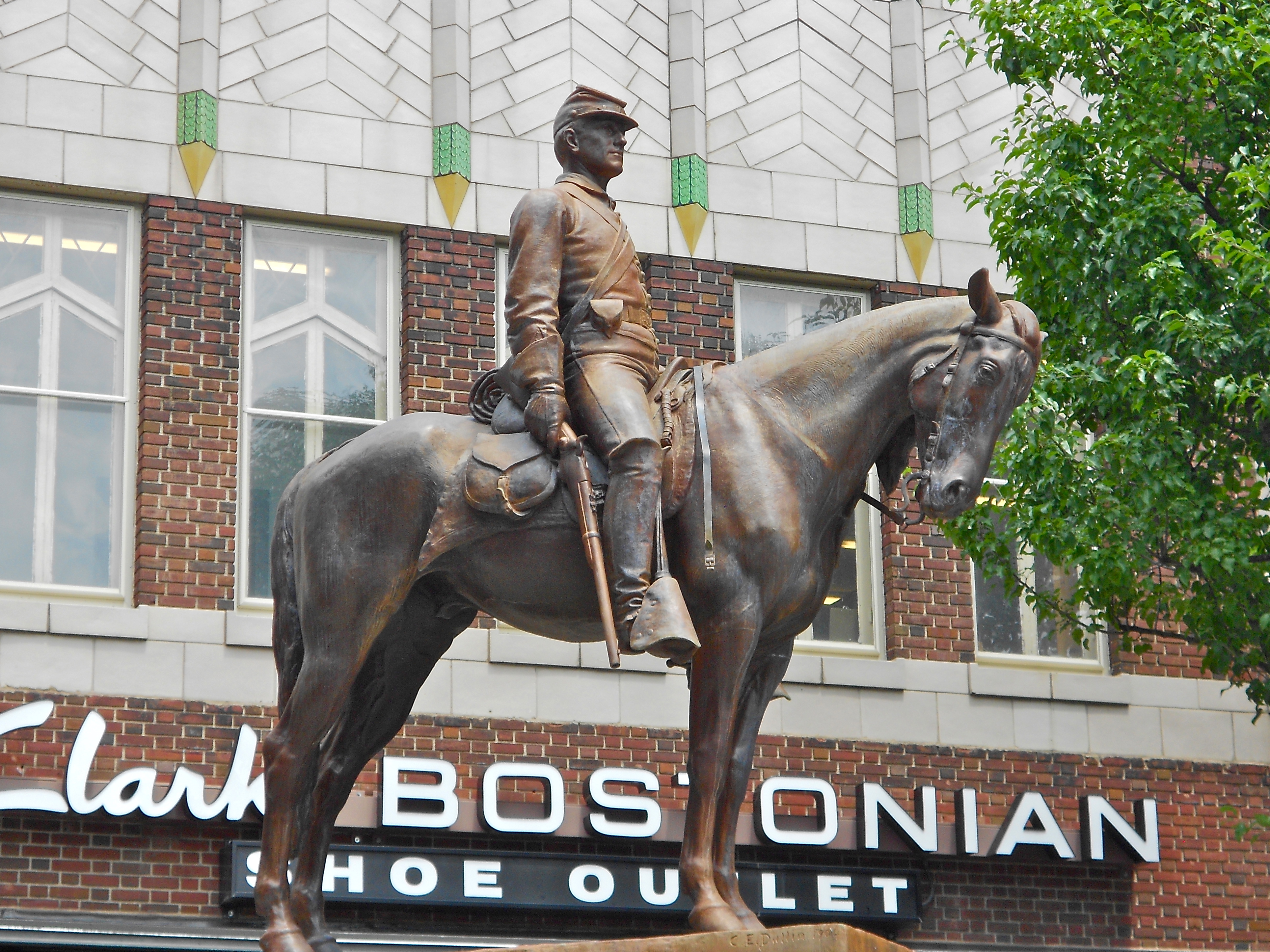
The sculpture Sentry, erected in Center Square in 1904, shows a Union cavalry soldier on sentry duty.
During the American Civil War, the Battle of Hanover was fought on June 30, 1863. Union cavalry under Judson Kilpatrick encountered Confederate cavalry under J.E.B. Stuart and a sharp fight ensued in the town and in farm fields to the south, particularly along Frederick Street. The inconclusive battle delayed the Confederate cavalry on their way to the Battle of Gettysburg. Three days before the battle, another detachment of Virginia cavalry had briefly occupied Hanover, collecting supplies and horses from local citizens.
Over the years, its industries have included the making of cigars, gloves, silks, flavine, water wheels, flour, shirts, shoes, machine-shop products, furniture, wire cloth, and ironstone grinders.
The town has lent its name to a brand of canned vegetables, and a mail-order gift company based there.
The Hanover Historic District, Eichelberger High School, George Nace (Neas) House, and US Post Office-Hanover are listed on the National Register of Historic Places.[6]
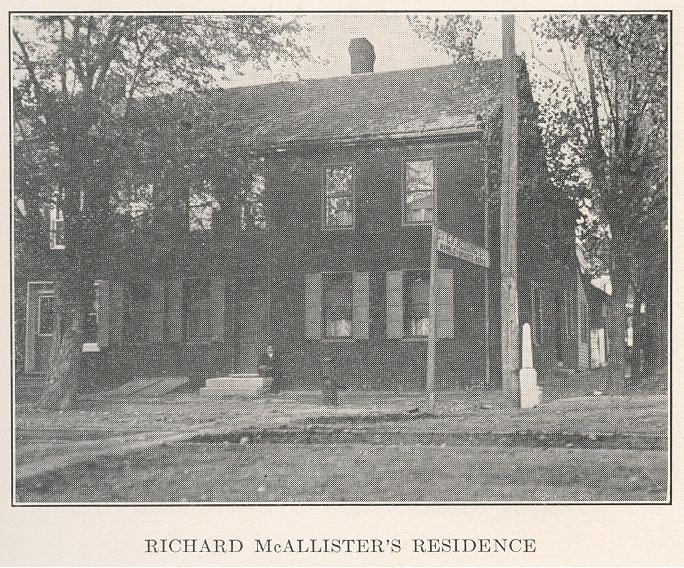  Richard McAllister's Residence |
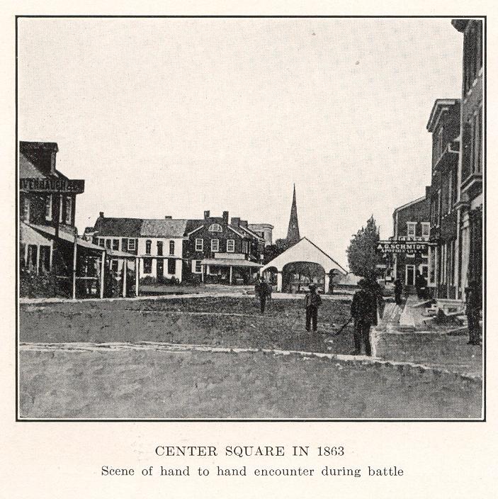  Center Square in 1863 |
  Center Square in 1873 |
  The first railroad station in Hanover |
Demographics[]
| Historical populations | |||
|---|---|---|---|
| Census | Pop. | %± | |
| 1820 | 946 | ||
| 1830 | 1,005 | 6.2% | |
| 1840 | 1,070 | 6.5% | |
| 1850 | 1,210 | 13.1% | |
| 1860 | 1,630 | 34.7% | |
| 1870 | 1,839 | 12.8% | |
| 1880 | 2,317 | 26.0% | |
| 1890 | 3,746 | 61.7% | |
| 1900 | 5,320 | 42.0% | |
| 1910 | 7,057 | 32.7% | |
| 1920 | 8,664 | 22.8% | |
| 1930 | 11,805 | 36.3% | |
| 1940 | 13,076 | 10.8% | |
| 1950 | 14,048 | 7.4% | |
| 1960 | 15,538 | 10.6% | |
| 1970 | 15,623 | 0.5% | |
| 1980 | 14,890 | −4.7% | |
| 1990 | 14,399 | −3.3% | |
| 2000 | 14,535 | 0.9% | |
| 2010 | 15,289 | 5.2% | |
| Est. 2012 | 15,349 | 5.6% | |
| [7][8][9] | |||
As of the census[8] of 2000, there were 14,535 people, 6,605 households, and 3,817 families residing in the borough. The population density was 3,981.7 inhabitants per square mile (1,537.5/km²). There were 6,982 housing units at an average density of 1,912.6 per square mile (738.6/km²). The racial makeup of the borough (as of 2010 census) was 91.86% White, 1.18% African American, 0.21% Native American, 1.02% Asian, 1.02% Pacific Islander, 0.74% from other races, and 1.64% from two or more races. Hispanic or Latino of any race were 7.33% of the population. The ancestries for Hanover include: German (42%), Irish (11%), United States (10%), English (8%), Italian (3%), and Dutch (2%).
There were 6,605 households out of which 23.4% had children under the age of 18 living with them, 44.6% were married couples living together, 9.4% had a female householder with no husband present, and 42.2% were non-families. 36.3% of all households were made up of individuals and 16.6% had someone living alone who was 65 years of age or older. The average household size was 2.16 and the average family size was 2.81.
In the borough the population was spread out with 20.1% under the age of 18, 8.0% from 18 to 24, 28.0% from 25 to 44, 22.6% from 45 to 64, and 21.2% who were 65 years of age or older. The median age was 40 years. For every 100 females there were 91.4 males. For every 100 females age 18 and over, there were 87.5 males.
The median income for a household in the borough was $35,536, and the median income for a family was $45,156. Males had a median income of $31,206 versus $21,512 for females. The per capita income for the borough was $20,516. About 4.5% of families and 7.7% of the population were below the poverty line, including 8.7% of those under age 18 and 6.4% of those age 65 or over.
The Greater Hanover area has a population of about 55,000 residents. The community is made up of several areas such as Hanover Borough, Penn Township, Heidelberg Township, Manheim Township, West Manheim Township, Conewago Township, Berwick Township, and Union Township. All of these areas have Hanover, PA listed as their address.
Hanover, Pennsylvania is known by many as the snack food capital of the United States. Hanover has been featured multiple times on the Food Network. It is home to Utz's Quality Foods and Snyder's of Hanover and in nearby areas there are others including Hanover Foods, Wolfgang Candy, Martin's Potato Chips, Hershey Foods, and Gibbles Potato Chips, among others. Most of these factories give free tours.
The Vulcan Materials Company owns a large limestone quarry located to the north of Hanover, with an office on Oxford Avenue.
Retail areas[]
Pretzel company Snyder's of Hanover is located in its namesake town.
UTZ Potato Chip factory was founded in Hanover and still produces its products there along with a UTZ outlet store.
A major retail area in the greater Hanover region is along Eisenhower Drive, known as "The Golden Mile." This four lane road stretches east to the intersection at Eisenhower Drive and Broadway (Route 194) and west to the intersection at Eisenhower Drive and Carlisle Street (Route 94). Some of the major retail businesses on "The Golden Mile" includes Walmart, Arbys, AC Moore, GameStop, TJ Maxx, La Cucina, M&T Bank (2 locations), Best Wok, The Home Depot, Kohl's, Staples, Texas Roadhouse, Ruby Tuesday, Perkins, Dunkin Donuts, Red Lobster, Lowe's, Giant, R.C. Hanover Movies 16, McDonalds, Chilis, Wendy's, Shultz's Delicatessen and Sonic America's Drive In.
The other major retail area in Hanover is the newly completed Gateway Hanover complex, which runs parallel to "The Golden Mile." This new shopping center was completed in 2011, and is anchored by Target, Hobby Lobby, Ross, PetSmart, Rue 21. Pad users include Olive Garden, Long Horn, Five Guys Burgers, Subway, Starbucks, Fulton Bank, Buffalo Wild Wings and some other local small businesses.
Another major shopping center in Hanover is the North Hanover Mall.
Education[]
The Hanover area is served fully by two school districts, partially by third, and has one private high school. The Hanover Public School District serves Hanover Borough and has five schools:
- Clearview Elementary School
- Hanover Street Elementary School
- Washington Elementary School
- Hanover Middle School
- Hanover High School
Students may also attend one of the Commonwealth's multiple cyber charter schools at no additional cost to the family or student. The local school district pays the Pennsylvania Department of Education set tuition fee to the cyber charter school that the student chooses to attend. Alternatively, the Commonwealth of Pennsylvania permits parents to home school their children or they may attend a private school.[10]
The South Western School District serves the area around Hanover Borough, which includes Penn Township, Manheim Township and West Manheim Township. South Western School District operates six schools:
- Baresville Elementary School
- Manheim Elementary School
- Park Hills Elementary School
- West Manheim Elementary School
- Emory H. Markle Intermediate School (middle school)
- South Western High School
Conewago Township is served by Conewago Township Elementary School, which is part of the Conewago Valley School District in adjacent Adams County.
The private high school is Delone Catholic High School is in adjacent McSherrystown, Pennsylvania.
Despite the Hanover area's size, there are no colleges. However, the Empire Beauty School has a campus in Hanover, and the Practical Nursing Program has classrooms at Hanover High School. HACC and York College also offer classes at Hanover and South Western high schools. Pennsylvania State University's York Campus also offers select classes in the Hanover area.
Places of interest[]


Hanover Theater, built 1928
Some local places of interest in the Hanover area include:
- [1] - So's Taekwondo School. High quality Martial Art and fitness facility. Est 1976.
- Neas House - Local history museum of the Hanover Area Historical Society
- Hanover Shoe Company – A large shoe factory from 1910, now converted into apartments.
- Hanover Farmer's Market – since 1815
- Hanover Amish Markets - 50,000 sq. ft. local market
- Lincoln Speedway
- Timeline Arcade – Classic Arcade Downtown Hanover, Pa
- Hanover Theater – built 1928
- Eichelberger Performing Arts Center
- Guthrie Memorial Library, Hanover's Public Library
- Utz potato chip factory
- Codorus State Park has a large artificial lake, pontoon boat rentals, motor boat rentals, canoe rentals, row boat rentals, paddle boats, disc golf courses, and one of the largest pools in the state of Pennsylvania
- North Hanover Mall
- Snyder's of Hanover
- Link's Music, established in 1981, has the largest showroom of PA, lighting, drums, guitars, guitar and bass amplifiers, and DJ equipment in York, Adams, and Carroll Counties.
- Sheppard Mansion
- Emeco Factory – Manufactures the Emeco 1006
- TWR Tim Wagaman Racing. 2006
Transportation[]
The Hanover area is served by Pennsylvania Routes 94, 194, 116, and 216. Route 94 (Carlisle Street/Pike and Baltimore Street/Pike) intersects with Route 194 at the square and extends north to Carlisle, PA and south to Baltimore, MD. Route 194 (Broadway/Abbottstown Pike and Frederick Street/Hanover Pike) intersects with Route 94 and Route 116 at the square and extends north to Dillsburg, PA and south to Frederick, MD. Route 116 (York Street/Road and High Street/Hanover Road) overlaps Route 194 and runs through the square for three blocks. It extends west to McSherrystown, PA and east to Spring Grove, PA. Route 216 (Blooming Grove Road) branches southwest off of Route 116 and runs through Codorus State Park.
Hanover is served by 4 routes of the Rabbit Transit bus system. Route #16 connects Downtown Hanover to Downtown York. An unnumbered route transports employees from York to Hanover. Route #21 connects Downtown Hanover with North Hanover and the Homewood Retirement Village. Route #22 connects Downtown Hanover with North Hanover and South Hanover.
Special interest groups[]
- Azul Nox Encampment, Ordo Templi Orientis
- Boy Scout Troop 103
- Boy Scout Troop 110
- Amici d'Italia Italian Club of Hanover PA (meeting monthly at Virgilio's Ristorante-Pizzeria), 1154 W Elm Ave,Hanover - 717-630-9600
- Pennsylvania Southern Guard (McAllister's Rangers) Citizen Militia
Music groups[]
- Lyric Band of Hanover – 120-member concert band-founded in 1932
- Hanover Symphony Orchestra – started in 1995
- Lancers Drum and Bugle Corps – 100+-member alumni drum & bugle corps founded in 1920
- The Pixies Three – Teenage girl-group trio from 1963-1965 ("Birthday Party", "442 Glenwood Avenue")
- Hip-Hop artist/group "7even 1ne 7even" (717) includes Dut,Big Ric
Movies[]
The bowling scene in the movie Girl, Interrupted was filmed in the basement of the Sheppard Mansion. The mansion and its twin, Myers Mansion, across town both still have bowling alleys in their basements.[11]
References[]
- Prowell, George R. (1907). History of York County, Pennsylvania. I. Chicago: J.H. Beers. http://archive.org/details/historyofyorkcou00prow.
- ^ "US Gazetteer files: 2010, 2000, and 1990". United States Census Bureau. 2011-02-12. http://www.census.gov/geo/www/gazetteer/gazette.html. Retrieved 2011-04-23.
- ^ "Drawing the Line: How Mason and Dixon Surveyed the Most Famous Border in America" By Edwin Danson, Published by John Wiley and Sons, 2001
- ^ "Hanover Centennial of Incorporation of the Borough of Hanover Pennsylvania" issued by The Hanover Centennial Committee, Published by E.L. Koller 1915
- ^ "Monticello Research Report", J.R. McGrew, May 1991.
- ^ History of York County Pennsylvania (Volume II). Chicago: J. H. Beers. 1907. p. Baltimore defenders. http://www.ebooksread.com/authors-eng/john-gibson/history-of-york-county-pennsylvania-from-the-earliest-time-to-the-present-sbi/page-121-history-of-york-county-pennsylvania-from-the-earliest-time-to-the-present-sbi.shtml. Retrieved May 7, 2013.Contributor: York College of Pennsylvania, Schmidt Library Collection: yorkcollegeofpennsylvania
- ^ "National Register Information System". National Register of Historic Places. National Park Service. 2010-07-09. http://nrhp.focus.nps.gov/natreg/docs/All_Data.html.
- ^ http://www2.census.gov/prod2/decennial/documents/03815512v1ch09.pdf
- ^ a b "American FactFinder". United States Census Bureau. http://factfinder2.census.gov. Retrieved 2008-01-31.
- ^ "Annual Estimates of the Resident Population". U.S. Census Bureau. http://www.census.gov/popest/data/cities/totals/2012/SUB-EST2012-3.html. Retrieved 22 November 2013.
- ^ Pennsylvania Department of Education, Charter Schools, 2013
- ^ http://www.hanoverareahistoricalsociety.org/mansion.htm
External links[]
| |||||||||||||||||||||||

| This page uses content from the English language Wikipedia. The original content was at Hanover, Pennsylvania. The list of authors can be seen in the page history. As with this Familypedia wiki, the content of Wikipedia is available under the Creative Commons License. |