| ||||||||||||||
| Guntur district గుంటూరు జిల్లా |
|
|---|---|
| — District — | |
 |
|
| Coordinates: Coordinates: | |
| Country | |
| State | Andhra Pradesh |
| Population | |
| • Total | 48,89,230(2,011 census) |
| Languages | |
| • Official | Telugu |
| Time zone | IST (UTC+5:30) |
Guntur district is an administrative district in the Coastal Andhra region of the Indian state of Andhra Pradesh. The administrative seat of the district is located at Guntur, the largest city of the district in terms of area and population.[1] It has a coastline of approximately 100 km and is situated on the right bank of Krishna River, that separates it from Krishna district and extends till it empties into the Bay of Bengal. It is bounded on the south by Prakasam district and on the west by the state of Telangana.[2] It has an area of 11,391 km2 (4,398 sq mi) and is the 2nd most populous district in the state a population of 4,889,230 as per 2011 census of India.[3]
Etymology[]
There are several opinions on the meaning and origin of the word Guntur. The word owes its origin to words like gundu (a rock), gunta (a pond) and kunta (1/3 of an acre). We know that in Sanskrit Guntur is called Garthapuri (Guntlapuri).[4]
History[]
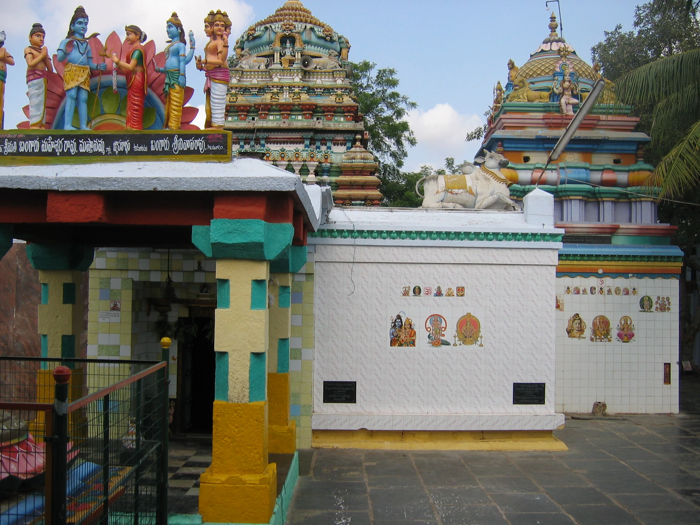
An old temple at Garthapuri (Guntur)
The original Sanskrit name (ancient Vedic culture/tradition) for Guntur was Garthapuri. The 'Agasthyeswara Sivalayam' in the old city of Guntur is an ancient temple for Siva.
It has inscriptions on two stones in 'Naga Lipi' (ancient script). It is said that Agastya built the temple in the last Treta-Yuga around the Swayambhu Linga and hence the name. The 'Nagas' were said to have ruled the region. The place of Sitanagaram and the Guthikonda Caves can be traced (through Vedic Puranas) back to the last Treta-Yuga and Dwapara-Yuga (Traditional Time scale: 1.7 to 0.5 million years ago).
Guntur District is home to the second oldest evidence of humans in India, in the form of Palaeolithic (old stone age) implements. Ancient history can be traced from the time of Sala kings who ruled during the 5th century BCE. The earliest reference to Guntur, a variant of Guntur, comes from the Idern plates of Ammaraja I (922–929 CE), the Vengi Chalukyan King. Guntur also appears in another two inscriptions dated 1147 and 1158 CE.
Since the beginning of Buddhist time, Guntur stood in the forefront in matters of culture, education and civilization. Gautama Buddha preached at Dharanikota/Dhanyakatakam near Guntur and conducted Kalachakra ceremony, which takes its antiquity to 500 BCE.[5] Taranatha, a Buddhist monk writes: "On the full moon of the month Caitra in the year following his enlightenment, at the great stupa of Dhanyakataka, the Buddha emanated the mandala of "The Glorious Lunar Mansions" (Kalachakra).[6] Buddhists established universities in ancient times at Dhanyakataka and Amaravathi. Scores of Buddist stupas were excavated in the villages of Guntur district. Acharya Nagarjuna, an influential Buddhist philosopher taught at Nagarjunakonda and is said to have discovered Mica in 200 BCE. Chinese traveller and Buddhist monk Hiuen Tsang (Xuanzang) visited Amaravati in 640 C.E., stayed for sometime and studied 'Abhidhammapitakam'. He observed that there were many Viharas and some of them were deserted, which points out that Hinduism was gaining ground at that time. Xuanzang wrote a glorious account of the place, Viharas and monasteries that existed.[7]
Guntur was successively ruled by famous dynasties such as the Satavahanas, Andhra Ikshvakus, Pallavas, Ananda Gotrikas, Vishnukundina, Kota Vamsa, Chalukyas, Cholas, Kakatiyas, Vijayanagara and Qutb Shahis during ancient and medieval times. The famous battle of Palnadu which is enshrined in legend and literature as Palnati Yuddham was fought in Guntur district in 1180 CE.
Guntur became part of the Mughal empire in 1687 CE when the emperor Aurangzeb conquered the Qutb Shahi sultanate of Golconda, of which Guntur was then a part. In 1724 CE, Asaf Jah, viceroy of the empire's southern provinces, declared his independence as the Nizam of Hyderabad. The coastal districts of Hyderabad, known as the Northern Circars, were occupied by the French in 1750. Raja Vasireddy Venkatadri Nayudu (1783–1816) shifted his capital from Chintapalli in Krishna district to Amaravati across the river Krishna. He ruled with munificence and built many temples in Guntur region. Guntur was brought under the control of the British East India Company by 1788, and became a district of Madras Presidency.
Post Independence[]
The Guntur region played a significant role in the struggle for independence and the formation of Andhra Pradesh. The northern, Telugu- speaking districts of Madras state, including Guntur, advocated to become a separate state after independence. The new state of Andhra Pradesh was created in 1953 from the eleven northern districts of Madras. In 1970, part of Guntur district was split off to become part of the Prakasam district.[8]
The district suffers from Naxalite insurgency and is a part of the Red Corridor.[9]
Geography[]
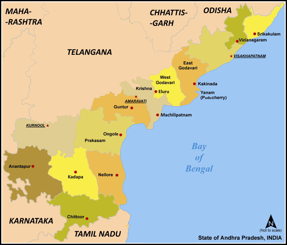

Districts of Andhra Pradesh
Guntur district occupies an area of approximately 11,391 square kilometres (4,398 sq mi),[10] comparatively equivalent to Indonesia's Bangka Island.[11] The Krishna River forms the northeastern and eastern boundary of the district, separating Guntur District from Krishna District. The district is bounded on the southeast by the Bay of Bengal, on the south by Prakasam District, on the west by Mahbubnagar District, and on the northwest by Nalgonda District.
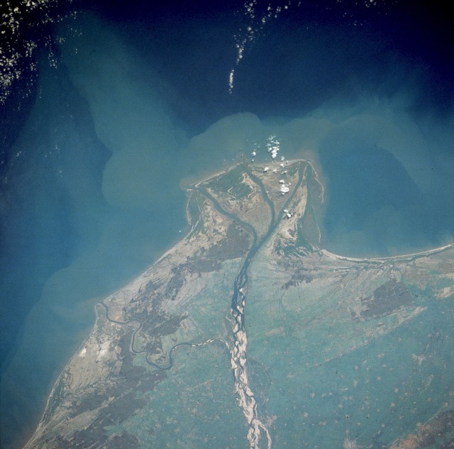

Guntur Coast by NASA
Guntur Coast is located on the south east coast of India (also known as the Coromandel Coast) (quotes from NASA site). River Krishna merges into Bay of Bengal at the coastal area of Guntur district. The braided stream channels, broad floodplain, and extensive sandbars suggest that this part of the Krishna River flows through relatively flat terrain and carries substantial amounts of sediment, especially during the monsoon season. Surya Lanka near Bapatla Bobbara Lanka in Repalle are tourist beaches in Guntur coastline.
Economy[]
Paddy, tobacco, cotton and chillies are the main agricultural products cultivated in the district.
Household indicators[]
In 2007–2008 the International Institute for Population Sciences interviewed 1230 households in 36 villages across the district.[12] They found that 90.8% had access to electricity, 93.2% had drinking water, 52.2% toilet facilities, and 46% lived in a pucca (permanent) home.[12] 30.3% of girls wed before the legal age of 18[13] and 74% of interviewees carried a BPL card.[12]
Divisions[]
It is divided into three revenue divisions (Guntur, Tenali and Narasaraopet) with 58 mandals.
Mandals[]
Guntur district is divided into 58 mandals for ease of administration and taking the government closer to the people.
- Achampeta
- Amaravathi
- Amruthaluru
- Bapatla
- Bellamkonda
- Bhattiprolu
- Bollapalle
- Chebrole
- Cherukupalle
- Chilakaluripet
- Dachepalli
- Duggirala
- Durgi
- Edlapadu
- Guntur
- Gurazala
- Ipuru
- Kakumanu
- Karempudi
- Karlapalem
- Kollipara
- Kolluru
- Krosuru
- Machavaram
- Macherla
- Mangalagiri
- Medikonduru
- Muppalla
- Nadendla
- Nagaram
- Nekarikallu
- Narasaraopet
- Nizampatnam
- Nuzendla
- Pedakakani
- Pedakurapadu
- pedanandipadu
- Phirangipuram
- Piduguralla
- Pittalavanipalem
- Ponnur
- Prathipadu
- Rajupalem
- Rentachintala
- Repalle
- Rompicherla
- Sattenapalli
- Ashiq Nagar
- Savalyapuram
- Tadikonda
- Tenali
- Tadepalli
- Thulluru(PEDAPARIMI)
- Tsunduru
- Vatticherukuru
- Veldurthy
- Vemuru
- Vinukonda
Demographics[]
According to the 2011 census Guntur district has a population of 4,889,230,[14] roughly equal to the Central African Republic[15] or the US state of Alabama.[16] This gives it a ranking of 22nd in India (out of a total of 640).[14] The district has a population density of 429 inhabitants per square kilometre (1,110 /sq mi) .[14] Its population growth rate over the decade 2001–2011 was 9.5%.[14] Guntur has a sex ratio of 1003 females for every 1000 males,[14] and a literacy rate of 67.99%.[14]
Guntur district covers an area of 11,391 km² and has a population of 4889230 of which 2441128 males and 2448102 females as of 2011.[17]
Languages[]
Telugu is the main language spoken in this district. The Second official language is Urdu.[18]
Educational Institutions[]
Guntur has also many educational institutions such as Hindu college, TJPS College,MBTS Polytechnic, Katuri Medical College,Jagarlamudi KuppuSwamy Chowdary College, Guntur Medical College, Vignan University, RVR & JC College of Engineering, NRI Medical College, Acharya Nagarjuna University, Hindu College, Andhra Christian College, and Bhashyam Group of Institutions.
Guntur has two of only seven deemed universities in Andhra Pradesh, namely Vignan University and K L University.
Culture[]
Places of historical importance in Guntur District are Amaravathi, Bapatla, Ponnur, Bhattiprolu, Vinukonda, Kotappakonda, Undavalli caves, Gurazala, Macherla, Kondavid fort, Tenali and the archeological museum in Guntur.
Temples[]
Number of temples were constructed in Krishna valley during the reign of Vasireddy Venkatadri Nayudu. Tall towers (Gaali Gopuram) of these temples in many villages and towns of Guntur district stand testimony to his devotion and munificence.
Kotappakonda
Kulothunga Chola's inscription dated 1172 A.D. reveals the history of this temple.[19]
See also[]
- Guntur City
- Guntur Coast
- Guntur Tourism
- Timeline of Guntur
- List of Buddhist topics
References[]
- ^ Cite error: Invalid
<ref>tag; no text was provided for refs nameddistrict_info - ^ "District Profile". National Informatics Centre. http://guntur.nic.in/dist-profile.html. Retrieved 27 April 2015.
- ^ "Guntur district". AP state portal. http://www.ap.gov.in/about-ap/districts/guntur/. Retrieved 18 January 2016.
- ^ About Guntur- Zilla Parishad Guntur. Zpguntur.ap.nic.in. Retrieved on 2011-12-29.
- ^ Buddha's Preaching of the Kalachakra Tantra at the Stupa of Dhanyakataka, H. Hoffman, in: German Scholars on India, Vol. I, 1973, pp. 136–140, Varanasi
- ^ Taranatha; The history of the Kālacakra tradition in Sambhala and India
- ^ In the footsteps of Xuanzang
- ^ Law, Gwillim (25 September 2011). "Districts of India". Statoids. http://www.statoids.com/yin.html. Retrieved 11 October 2011.
- ^ "83 districts under the Security Related Expenditure Scheme". IntelliBriefs. 11 December 2009. http://intellibriefs.blogspot.com/2009/12/naxal-menace-83-districts-under.html. Retrieved 17 September 2011.
- ^ Srivastava, Dayawanti et al. (ed.) (2010). "States and Union Territories: Andhra Pradesh: Government". India 2010: A Reference Annual (54th ed.). New Delhi, India: Additional Director General, Publications Division, Ministry of Information and Broadcasting (India), Government of India. pp. 1111–1112. ISBN 978-81-230-1617-7.
- ^ "Island Directory Tables: Islands by Land Area". United Nations Environment Program. 18 February 1998. http://islands.unep.ch/Tiarea.htm. Retrieved 11 October 2011. "Bangka 11,413"
- ^ a b c "District Level Household and Facility Survey (DLHS-3), 2007–08: India. Andhra Prades" (PDF). International Institute for Population Sciences and Ministry of Health and Family Welfare. 2010. http://www.rchiips.org/pdf/rch3/report/AP.pdf. Retrieved 2011-10-03.
- ^ "How Do I? : Obtain Marriage Certificate". National Portal Content Management Team, National Informatics Centre. 2005. http://india.gov.in/howdo/howdoi.php?service=3. Retrieved 2011-10-03. "To be eligible for marriage, the minimum age limit is 21 for males and 18 for females."
- ^ a b c d e f "District Census 2011". Census2011.co.in. 2011. http://www.census2011.co.in/district.php. Retrieved 2011-09-30.
- ^ US Directorate of Intelligence. "Country Comparison:Population". https://www.cia.gov/library/publications/the-world-factbook/rankorder/2119rank.html. Retrieved 2011-10-01. "Central African Republic 4,950,027"
- ^ "2010 Resident Population Data". U. S. Census Bureau. http://2010.census.gov/2010census/data/apportionment-pop-text.php. Retrieved 2011-09-30. "Alabama 4,779,736"
- ^ Provisional Population Totals. Census of India 2011. Andhra Pradesh. censusindia.gov.in
- ^ A. R. Fatihi (4 April 2003). "Urdu in Andhra Pradesh". In M. S. Thirumala. Language in India. 3. http://www.languageinindia.com/april2003/urduinap.html.
- ^ Kotappakonda.com
External links[]

|
Nalgonda district, Telangana | Nalgonda district, Telangana Krishna district |
Krishna district |
|
| Mahbubnagar district, Telangana | Krishna district | |||
 Guntur district | ||||
| Prakasam district | Prakasam district | Bay of Bengal |
| |||||||||||||||||
| ||||||||||||||||||||||||||
| This page uses content from the English language Wikipedia. The original content was at Guntur district. The list of authors can be seen in the page history. As with this Familypedia wiki, the content of Wikipedia is available under the Creative Commons License. |